Mori Atlas logo
Nature reserveDolina Postomii Nature Reserve

Tracing the protected riparian terrain and oak-hornbeam forest boundaries in western Poland

Dolina Postomii Nature Reserve: A Protected Mosaic of Forest and River Valley Landscapes

Dolina Postomii Nature Reserve represents a critical protected landscape within Lubusz Voivodeship, safeguarding the complex transition between steep forested terraces and the Postomia River floodplain. This protected area serves as an essential ecological corridor, featuring well-preserved oak-hornbeam stands and diverse alder-ash woodland. The site illustrates the natural topography of the Warta river basin, offering a clear map of forest, meadow, and wetland communities that remain rare in the surrounding agricultural lowlands.

nature reserveforest reserveriver valleyfloodplainwetlandmeadow

Dolina Postomii Nature Reserve

Nature reserve

Park overview

Structured park overview, official facts, and landscape profile for Dolina Postomii Nature Reserve

Dolina Postomii Nature Reserve park facts, protected area profile, and essential visitor context

Review the core facts for Dolina Postomii Nature Reserve, including designation, size, terrain, visitor scale, habitats, and operating context in one park-focused overview.

About Dolina Postomii Nature Reserve

Dolina Postomii Nature Reserve is a compact but ecologically rich protected area in western Poland, situated in the Lubuskie Voivodeship within the Ujście Warty Landscape Park. The reserve was created to safeguard the natural values of the edge of the Postomia River valley between Lemierzyce and Słońsk, a section of valley that simultaneously marks the southern edge of the broad Warta pradoliny, the ancient glacial corridor of the Warta River. Its location inside a major protected landscape links this small reserve to a much larger system of habitat conservation along Poland's border with Germany.

Ecologically, the reserve is defined by a sharp contrast in habitats over a very short distance. The valley floor is covered by sedge and meadow communities, fringed by a narrow strip of alder-ash floodplain woodland associated with the Postomia River. Above this wetter zone, on the higher terraces and along the steep valley edges, lie well-preserved fragments of oak-hornbeam forest (grąd) together with acidophilous oak woodland. This compressed layering of habitats is unusual in the intensively used lowlands of western Poland and gives the reserve its conservation importance.

The area is managed through active protection, a deliberate choice that reflects the presence of multiple threatened habitat types and species. The forested core of the reserve contains more than 80 monumental trees, which serve not only as landmarks of mature woodland but also as habitat for rare fungi, saproxylic insects, and other invertebrates. The reserve lies entirely on land belonging to the State Treasury and managed by the State Forests enterprise, specifically the Ośno Lubuskie Forest District.

An educational nature trail runs through the reserve, including a designated viewpoint, allowing visitors to experience the contrast between the flat valley floor and the forested higher ground that defines the protected landscape. Although modest in size, Dolina Postomii is an important local stronghold for habitat types listed under Annex I of the EU Habitats Directive and supports breeding populations of many rare and declining species.

Quick facts and research context for Dolina Postomii Nature Reserve

Dolina Postomii Nature Reserve is a forest reserve established by regulation of the Lubuskie Voivodeship governor on 6 January 2005. The reserve lies in Lubuskie Voivodeship, powiat sulęciński, gmina Słońsk, and is fully nested within the boundaries of the Ujście Warty Landscape Park. It covers roughly 68.66 hectares of state-owned forest land administered by the State Forests enterprise, specifically the Ośno Lubuskie Forest District.

The reserve protects the southern edge and floor of the Postomia River valley between the villages of Lemierzyce and Słońsk, a section of the valley that also forms the edge of the much broader Warta pradoliny. Habitats of European Union interest under the EU Habitats Directive are present on the site, and reserve management is active.

Protection and recognition

Documented terrestrial protection scope and conservation designation facts

Dolina Postomii Nature Reserve Protection Status and Recognition Data

Dolina Postomii Nature Reserve maintains a documented terrestrial protection scope without supplementary international recognition sources. Official records outline the baseline conservation designation and management framework governing the natural area.

Protection details

Protection scope
Terrestrial
Transboundary protection
No
Park context

Deeper park guide and search-rich context for Dolina Postomii Nature Reserve

Dolina Postomii Nature Reserve history, landscape, wildlife, and travel context

Explore Dolina Postomii Nature Reserve through its history, landscape character, ecosystems, wildlife, conservation priorities, cultural context, and seasonal travel timing in a structured park guide built for atlas discovery and search intent.

Why Dolina Postomii Nature Reserve stands out

Dolina Postomii Nature Reserve is best known for its very well-developed fragments of oak-hornbeam forest (grąd) and acidophilous oak forest on the steep terraces of the Postomia valley, as well as for the narrow but ecologically important band of alder-ash floodplain forest lining the river. The reserve is also notable as a refuge for rare and declining breeding birds and for a remarkable diversity of longhorn beetles, with around 32 species recorded, including several that are threatened in western Poland. The site is further valued as part of the larger conservation network centered on the Warta river confluence area, where river valley, floodplain, and forest edge habitats meet the broader wetland system protected by the surrounding landscape park.
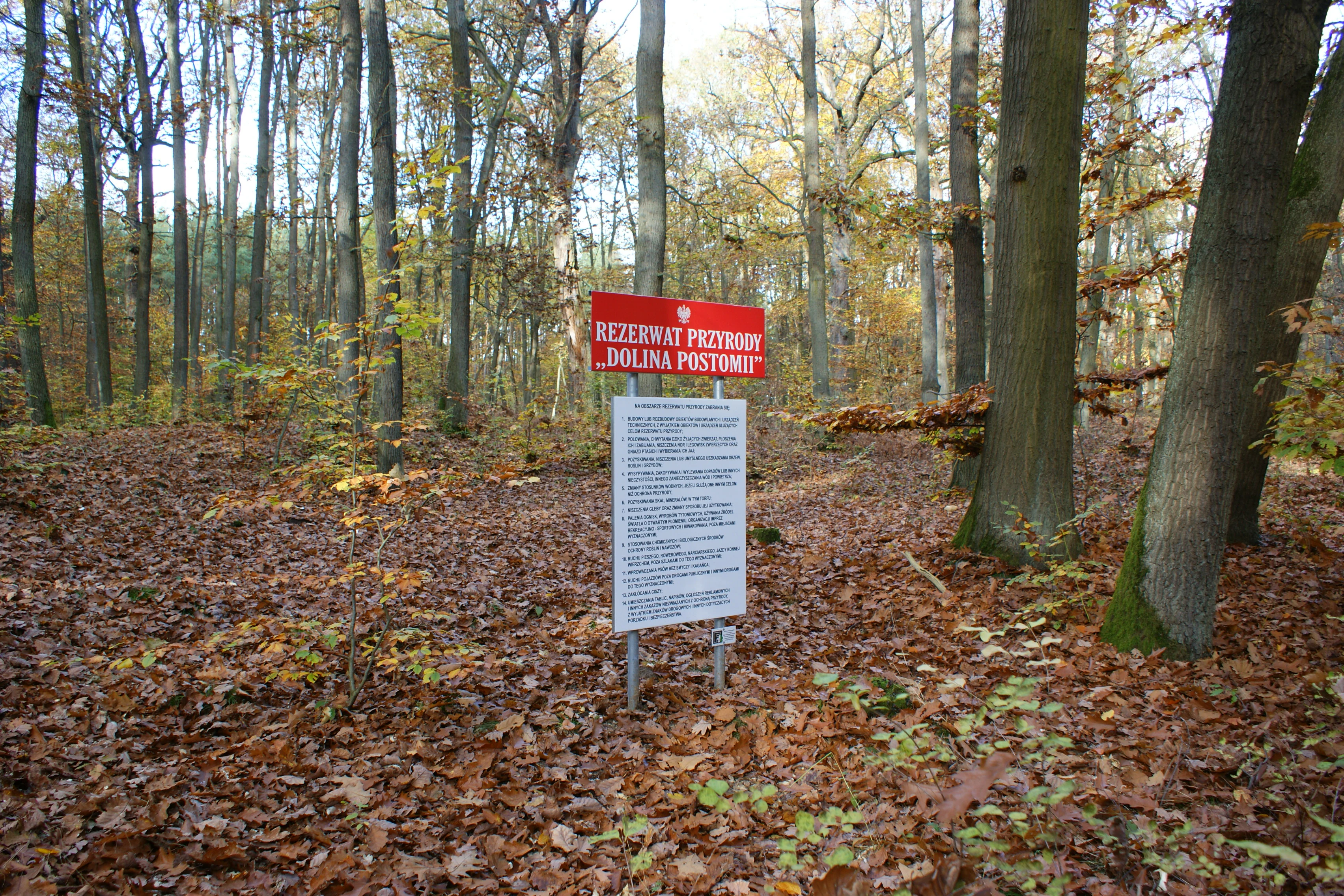
A red and white information sign stands in the middle of a forest floor covered with autumn leaves, marking the Dolina Postomii Nature Reserve.
Information sign at the boundary of Dolina Postomii Nature Reserve.

Dolina Postomii Nature Reserve history and protected-area timeline

Dolina Postomii Nature Reserve was established by Regulation No. 1 of the Wojewoda (voivodeship governor) of Lubuskie on 6 January 2005, issued under the Nature Protection Act of 16 April 2004. Its creation was driven by the recognition that the natural values of the Postomia valley edge between Lemierzyce and Słońsk required formal protection, both for their intrinsic ecological value and because the area falls within the broader Ujście Warty Landscape Park, where conservation of the Warta river system is a regional priority.

Since its establishment the reserve has been managed under active protection status, reflecting the degraded or altered character of some habitats and the need for ongoing intervention to maintain its forests, meadows, and dependent species. The reserve lands are held by the State Treasury and are administered by the Polish State Forests through the Ośno Lubuskie Forest District, which remains the principal management authority for the area.

Dolina Postomii Nature Reserve landscape and geographic character

The landscape of Dolina Postomii is defined by its position along the southern edge of the broad Warta pradoliny and along the small Postomia valley itself. The reserve combines a flat valley floor with steep valley edges and higher terraces, producing a sharply layered topography within a relatively small area. The Postomia River has incised a distinct corridor into the surrounding lowlands, so the slopes above the floodplain rise noticeably above the meadows and wetlands of the valley bottom.

From the upper terraces, visitors can look down onto the mosaic of sedge beds, wet meadows, and alder-ash floodplain woodland along the river, while immediately behind them lie the more closed oak-hornbeam and acidophilous oak forests that dominate the higher ground. Scattered monumental trees rise above the canopy, and a designated viewpoint within the reserve allows observation of this transition between open valley and forested slope. The wider setting is one of the western Polish lowlands, agriculture-dominated, with the Warta river system further shaping the regional landform.

Dolina Postomii Nature Reserve ecosystems, habitats, and plant life

The reserve protects a compressed sequence of habitat types that mirror the topography from river to terrace. In the valley bottom, sedge and reed communities (szuwar) blend into wet meadows, while directly along the Postomia River there is a narrow band of alder-ash floodplain forest, a habitat type strongly tied to the hydrology of the valley and particularly sensitive to changes in water regime.

On the higher terraces and on the steep valley edges, two contrasting forest types dominate. Well-developed oak-hornbeam forest (grąd), one of the most characteristic broadleaf forest types of the Polish lowlands, is preserved here in fragments considered among the better examples in the local region. Alongside it, acidophilous oak woodland (dąbrowa acydofilna) occupies drier, more nutrient-poor sites, increasing the overall habitat diversity. This mosaic supports habitat types listed in Annex I of the EU Habitats Directive, which is a formal recognition of the site's importance at the European scale.

The site also contains over 80 monumental trees, which are not only visual landmarks but also ecological structures that support specialized communities of fungi, invertebrates, and nesting sites for certain birds. The woodland is therefore deliberately managed to maintain these old trees as long-term habitat features.

Dolina Postomii Nature Reserve wildlife and species highlights

Dolina Postomii supports a notably diverse fauna for a reserve of its size, with particular significance for two groups: birds and longhorn beetles. The breeding avifauna of the reserve includes around 50 species, several of which are classified as rare, declining, or threatened in Poland, particularly species associated with mature broadleaf forest, transitional woodland edges, and river corridor habitats.

Equally remarkable is the beetle fauna, especially the longhorn beetles (Cerambycidae), with 32 species recorded in the reserve. Several of these are considered rare or threatened in western Poland and across the country. The concentration of monumental trees, as well as the diversity of forest types and habitats in close proximity, is the key driver of this beetle richness, since longhorn beetles depend strongly on decaying and old-growth wood structures.

Together, the bird community and beetle assemblage give the reserve an importance for invertebrate and bird conservation that extends well beyond its modest area, and they are a central justification for the reserve's active protection status.

Dolina Postomii Nature Reserve conservation status and protection priorities

Dolina Postomii Nature Reserve was established specifically to protect the natural values of the southern edge and valley floor of the Postomia River between Lemierzyce and Słońsk. Its conservation purpose is the preservation of both natural forest ecosystems and the non-forest ecosystems of the valley itself, in recognition that the long-term value of the site depends on maintaining the full gradient from river to forest edge rather than just the woodland areas.

The reserve is also significant because of its position inside the Ujście Warty Landscape Park, which is one of the most important wetland conservation areas along the Polish German border. By protecting the valley edge and floor of the Postomia, Dolina Postomii complements the wider landscape park, contributing to a more continuous network of habitats along the Warta river system.

Several habitats present in the reserve are listed in Annex I of the EU Habitats Directive, which underscores its European-level importance. Active protection measures are used to maintain particularly valuable features, including more than 80 monumental trees which serve as habitat for rare fungi, insects, and other invertebrates and which are treated as objects of special care.

Top sights and standout views in Dolina Postomii Nature Reserve

A compact forest reserve protecting both the edge and valley floor of the Postomia River, with excellent examples of oak-hornbeam forest and acidophilous oak woodland on the higher terraces and a narrow but ecologically rich alder-ash floodplain strip along the river. The reserve is one of the better-preserved grąd sites in the local region and is part of the larger conservation network of the Ujście Warty Landscape Park.

It hosts over 50 breeding bird species and around 32 longhorn beetle species, including several that are rare or threatened in western Poland, supported by more than 80 monumental trees and a diverse set of habitats of European interest. An educational nature trail with a viewpoint allows visitors to experience the dramatic transition from the wet valley floor to the forested slopes.

Best time to visit Dolina Postomii Nature Reserve

Spring and early summer are particularly rewarding for visiting Dolina Postomii, when the floodplain meadows and forest floor of the valley bottom come alive with wildflowers such as wood anemone, common snowdrop, lily of the valley, and pheasant's eye, and when the breeding bird activity in the valley and forest edges is at its peak. Late spring and early summer also tend to be the most comfortable period for exploring the educational nature trail and viewpoint.

Autumn offers quieter conditions for those focused on landscape and woodland character, with the contrast between the open valley and the forests above being especially clear. Winter visits are possible but are more suitable for observing the overall topography and old trees rather than the seasonal richness of flora and breeding fauna.


Monthly climate preview

Long-term representative temperature and precipitation averages across twelve months

Dolina Postomii Nature Reserve Climate Normals and Monthly Weather Patterns

Representative coordinate measurements reveal annual temperature swings alongside consistent monthly precipitation rates across the protected landscape. Examining the full twelve-month profile provides deeper analytical context for long-term climate normals.
Annual mean9 °C
-1 °C20 °C
Jan-1°
Feb
Mar
Apr
May14°
Jun18°
Jul20°
Aug20°
Sep15°
Oct
Nov
Dec
Warmest month
July

20 °C

Coolest month
January

-1.3 °C

Wettest month
July

2.5 mm/day

Driest month
April

1.1 mm/day

Park location guide

Geography guide, regional context, and park location map for Dolina Postomii Nature Reserve

Dolina Postomii Nature Reserve park geography, regions, and map view in Poland

Understand where Dolina Postomii Nature Reserve sits in Poland through a broader geographic reading of the surrounding landscape, nearby location context, and its mapped position within the national park landscape.

How Dolina Postomii Nature Reserve fits into Poland

Poland, officially the Republic of Poland, is a Central European country spanning from the Baltic Sea in the north to the Carpathian Mountains in the south. It borders Germany, Czech Republic, Slovakia, Ukraine, Belarus, Lithuania, and Kaliningrad Oblast. The country has a temperate climate, diverse landscapes, and is known for its rich history, cultural heritage, and strong economic position within the EU.

Wider geography shaping Dolina Postomii Nature Reserve in Poland

Poland occupies 312,696 km2 in Central Europe, extending from the Baltic Sea coast in the north to the Sudetes and Carpathian Mountains in the south. It borders Germany to the west, Czech Republic and Slovakia to the south, Ukraine and Belarus to the east, and Lithuania and Kaliningrad Oblast to the northeast. The landscape includes lowland plains, uplands, and mountain ranges.

Map view of Dolina Postomii Nature Reserve

Use this park location map to pinpoint Dolina Postomii Nature Reserve in Poland, understand its exact geographic position, and read its mapped placement within the surrounding landscape more clearly.

Pigeon | © OpenStreetMap contributors

Location context for Dolina Postomii Nature Reserve

Lubusz Voivodeship

Visual reference collection showcasing river valley terrain, floodplain forests, and steep wooded terraces

Dolina Postomii Nature Reserve Photos, Scenery, and Protected Landscape Views

Examine detailed field photography capturing the distinct topography, wetland mosaics, and mature forest habitats of Dolina Postomii Nature Reserve. Visual records illustrate the ecological transition from wet valley floors to elevated oak woodlands across the protected river corridor.

A red and white information sign stands in the middle of a forest floor covered with autumn leaves, marking the Dolina Postomii Nature Reserve.

A multi-level wooden observation tower stands at the edge of a forest, next to a small wooden picnic structure and interpretive signage.

Park atlas

Compare regional river valleys, wetland reserves, and lowland forest corridors.

Parks Near Dolina Postomii Nature Reserve and Surrounding Protected Landscapes

Browse protected areas near Dolina Postomii Nature Reserve to evaluate similar floodplain habitats and lowland forest reserves across the region. Regional park comparison reveals connected conservation networks and adjacent river valley ecosystems.
Protected landscapePoland
Mapped location lies within the park boundary#1 closest

Northwest

Park Krajobrazowy Ujście Warty: Protected Landscape and River Valley Atlas

Mapping wetland ecosystems and floodplain geography in western Poland

Park Krajobrazowy Ujście Warty preserves a significant lowland river valley landscape characterized by vast open pastures, marshes, and rare riparian oak forests. Located primarily within the Lubuskie region, this protected area offers a clear view into the floodplain processes of the Warta river basin, providing a distinct geographic context for wetland conservation and waterbird habitat mapping in Poland.

Area
194.96 km²
Established
1996
Relief
Lowland
Climate
Temperate
National parkLubusz Voivodeship
About 5.2 km away#2 closest

West

Park Narodowy „Ujście Warty” National Park: Regional Geography and Wetland Landscapes

A major protected riparian and floodplain zone in western Poland

Located in the Lubusz Voivodeship, Park Narodowy „Ujście Warty” features an extensive network of wetlands, marshes, and meadows at the Warta and Oder confluence. This atlas entry provides essential geographic context for the park's lowland terrain and riverine ecosystems, which are defined by constant shifts in water levels and seasonal flooding patterns that sustain dense bird populations.

Area
80.74 km²
Established
2001
Visitors
52K annual
Relief
Lowland
Watercolor illustration showing a river winding through rolling green hills with sparse vegetation
National parkLubusz Voivodeship
About 5.2 km away#3 closest

West

Warta Mouth National Park: A National Park Protecting Vital European Wetlands

Explore mapped protected areas and bird habitats in Lubusz Voivodeship.

Warta Mouth National Park, located in Poland's Lubusz Voivodeship, is a significant protected landscape safeguarding the ecologically rich confluence of the Warta and Oder rivers. As the nation's most recently established national park, it provides critical habitat for a vast array of migratory and breeding bird species within its extensive marshlands and floodplains. This park offers a unique opportunity for atlas-driven exploration of Central European wetland geography and the mapped boundaries of a vital conservation area.

Area
80.38 km²
Established
2001
IUCN
II
Visitors
52K annual
Protected areaLubusz Voivodeship
About 11 km away#4 closest

West

Ujście Warty Protected Area: Geography and Landscape Atlas of the Warta River Valley

Natura 2000 wetland and floodplain mapping in Lubusz Voivodeship

Examine the physical geography of Ujście Warty, a major lowland protected area in western Poland. This landscape features a unique layering of river arms, alluvial forests, and dry grasslands, serving as a vital ecological corridor within the broader Oder basin. Use this mapped overview to study the terrain features and structural connectivity of these significant floodplain habitats.

Area
332.15 km²
Water
Water-dominated
Watercolor illustration showing a winding river through a soft, green wetland landscape with distant rolling hills and scattered trees.
Protected areaLubusz Voivodeship
About 12 km away#5 closest

North

Ostoja Witnicko-Dębniańska: Mapped Protected Area and Regional Geography

An extensive mosaic of lowland forest and wetland habitats in Poland

The Ostoja Witnicko-Dębniańska sanctuary serves as a critical protected landscape, defined by its blend of managed forest stands, transitional peatlands, and dystrophic lakes. Positioned along the Warta river valley, this area provides a rich geographic context for understanding the wetland ecosystems of the Lubusz Voivodeship and the surrounding western Polish lowlands.

Area
469.93 km²
Established
2007
Scope
Terrestrial
Water
Major water bodies
Nature reserveLubusz Voivodeship
About 20 km away#6 closest

Northeast

Rezerwat przyrody Dębowa Góra: Protected Oak and Beech Woodland Geography in Lubusz Voivodeship

Analysis of a near-natural deciduous forest reserve in western Poland.

Rezerwat przyrody Dębowa Góra is a protected fragment of mature deciduous woodland located in Gorzów County. Its landscape preserves essential oak-lime-hornbeam forest stands, providing a glimpse into the natural lowland ecology of the Lubusz Voivodeship through structured active conservation and forest management.

Area
0.113 km²
Established
1995
Relief
Lowland
Climate
Temperate
Watercolor painting showing a winding river through a wetland with trees and hills in the background.
Nature reserveLubusz Voivodeship
About 23 km away#7 closest

Southwest

Mokradła Sułowskie Nature Reserve: Mapping Wetland Protected Areas in Lubusz Voivodeship

A comprehensive geographic atlas of Polish peatland and forest marsh habitats

The Mokradła Sułowskie nature reserve protects a vital cluster of eutrophic lakes and waterlogged mires in western Poland. This atlas entry provides a detailed look at its unique landscape, where divided northern and southern sections showcase diverse stages of marshland succession and regional biodiversity within the broader Lubusz Voivodeship.

Area
0.451 km²
Established
1990
Water
Water-dominated
Nature reserveLubusz Voivodeship
About 25 km away#8 closest

Southeast

Rezerwat przyrody Dolina Ilanki II: Protected Peatland and River Valley Geography

A vital nature reserve within the Ilanka River corridor

Rezerwat przyrody Dolina Ilanki II represents a key ecological site in the Lubusz Voivodeship. Focused on the conservation of spring-fed mires and alder swamp forests, the reserve forms a critical part of the larger Ilanka valley habitat network. Discover the terrain characteristics and mapped extent of this protected lowland wetland.

Area
0.113 km²
Established
2017
Relief
Lowland
Scope
Terrestrial

Common questions about visiting, size, designation, and location context for Dolina Postomii Nature Reserve

Dolina Postomii Nature Reserve FAQs for park facts, access, geography, and protected area context

Find quick answers about Dolina Postomii Nature Reserve, including protected-area facts, park geography, trail and visitor context, and how the park fits into its surrounding country and regional landscape.
MoriAtlas Explorer

Continue Your Protected Areas Search Across the Global Atlas

Deepen your exploration by continuing the structured search for national parks and protected areas worldwide. Utilize the comprehensive filtering capabilities to compare different conservation landscapes and refine your understanding of global park geography. Discover more about the distribution and characteristics of protected natural areas.

Global natural geography