

Mori Atlas logo
Protected landscapeDolní Poohří Nature Park

Mapping the floodplain ecosystems, meandering river channels, and cultural heritage of the Litoměřice District

Dolní Poohří Nature Park: A Protected Landscape Along the Lower Ohře River Corridor

(Přírodní park Dolní Poohří)

Dolní Poohří Nature Park preserves a seventeen kilometer corridor of the lower Ohře River within the Litoměřice District, safeguarding one of the few remaining softwood floodplain forest systems in the region. This protected landscape is defined by its free flowing river meanders, oxbow wetlands, and diverse riparian habitats that contrast with the surrounding agricultural tablelands. The area incorporates smaller nature reserves and cultural heritage sites including historic chateaus and monastic architecture, forming a integrated natural and cultural tapestry.

nature parklowland riverfloodplain forestmeandersriparian woodlandriparian habitat

Dolní Poohří Nature Park

Protected landscape

Park overview

Structured park overview, official facts, and landscape profile for Dolní Poohří Nature Park

Dolní Poohří Nature Park park facts, protected area profile, and essential visitor context

Review the core facts for Dolní Poohří Nature Park, including designation, size, terrain, visitor scale, habitats, and operating context in one park-focused overview.

About Dolní Poohří Nature Park

Dolní Poohří Nature Park is a regional protected area organized around the lower course of the Ohře River in the Litoměřice District of northern Bohemia. Designated in 2001, it follows the river's natural corridor in a thin arc roughly seventeen kilometers long and only one to three kilometers wide, encompassing about forty square kilometers of floodplain and adjacent terrain. Despite its modest breadth, the park occupies an important position in the regional geography because the lower Ohře is one of the few Central European rivers that still retains genuinely unconstrained meanders in an otherwise heavily modified agricultural lowland.

The defining landscape element is the river itself. The Ohře flows through the park as a freely meandering system, forming side arms, gravel islands, and abandoned channels, including the Malá Ohře side branch and the St. Kliment island. Surrounding the main channel, a network of silted-up dead arms recharges from floods and high groundwater, creating wetland habitats with restricted higher plant vegetation but high value for aquatic and amphibious life. These hydrological features are central to the park's identity: the park exists, in essence, to keep the lower Ohře functioning as a living river rather than allowing its backwaters and floodplain fringes to be drained or converted.

Geologically and geomorphologically, the park belongs to the broader Dolnooharská tabule region, with most of its territory in the Terezínská kotlina basin and smaller portions in the Hazmburská tabule and Řipská tabule plateaus. The result is a landscape that is dominated by flat alluvial surfaces but also interrupted by tableland edges, ravines, and occasional elevated terraces. This combination of low floodplain and adjoining uplands gives the park its characteristic cross-section: a green, meandering river corridor set between cultivated plateau surfaces and small historic towns.

Ecologically, the park's most important resource is its surviving floodplain forest. Although intensive land use has long since reduced such forests across much of Central Europe, the lower Ohře still preserves relict patches of softwood floodplain woodland that support dozens of threatened and protected species. To strengthen this ecological backbone, the park incorporates a network of smaller, strictly protected sites: the natural monument Evaňská rokle, a ravine-like valley, and three nature reserves, Loužek, Myslivna, and Pístecký les, each protecting a discrete fragment of the original woodland and riparian habitat.

The cultural layer of the park is closely tied to its geography. The most significant settlements are Libochovice, Budyně nad Ohří, and the market town Brozany nad Ohří, all perched on slightly higher ground above the floodplain. Their chateaus, castles, the Premonstratensian convent at Doksany, the hillfort at Levousy, and the ruined castle of Šebín together form a ring of heritage sites that frame the natural corridor. As a result, Dolní Poohří is best understood as an integrated cultural-natural landscape, where the meandering river, the relict floodplain forests, and the historic towns above the plain form a single coherent experience.

Quick facts and research context for Dolní Poohří Nature Park

Dolní Poohří Nature Park lies in the Litoměřice District of northern Bohemia, in the Czech Republic, and was designated in 2001 by the former district authority at Litoměřice. It covers close to forty square kilometers along the lower Ohře River, stretching between roughly Křesín and Bohušovice nad Ohří in a thin arc of about seventeen kilometers in length and only one to three kilometers in width. The park falls within the Dolnooharská tabule geomorphological region, specifically its Terezínská kotlina, Hazmburská tabule, and Řipská tabule subunits, with the Ohře as the overriding hydrological axis. Several smaller protected sites are nested inside the park, including the natural monument Evaňská rokle and the nature reserves Loužek, Myslivna, and Pístecký les, all of them focused on preserving fragments of the original floodplain landscape that once characterized the wider river corridor.

Protection and recognition

Explore documented terrestrial protection data and management scope for Dolní Poohří Nature Park.

Dolní Poohří Nature Park Protection Status and Conservation Recognition

Examine the verified terrestrial protection status and management scope recorded for Dolní Poohří Nature Park. Review official conservation data and designation details without external assumptions.

Protection details

Protection scope
Terrestrial
Transboundary protection
No
Park context

Deeper park guide and search-rich context for Dolní Poohří Nature Park

Dolní Poohří Nature Park history, landscape, wildlife, and travel context

Explore Dolní Poohří Nature Park through its history, landscape character, ecosystems, wildlife, conservation priorities, cultural context, and seasonal travel timing in a structured park guide built for atlas discovery and search intent.

Why Dolní Poohří Nature Park stands out

Dolní Poohří is known chiefly for the free, unconstrained meanders of the lower Ohře River and for the surviving fragments of floodplain forest that cling to its banks and abandoned arms. These relict patches of softwood floodplain woodland, together with the oxbows, side channels, and silty backwaters that still flood periodically, are the defining ecological features of the park. The protection status of these habitats is what the park was established to safeguard, and they remain its most distinctive visible and ecological signature in the intensively farmed Bohemian lowland landscape.
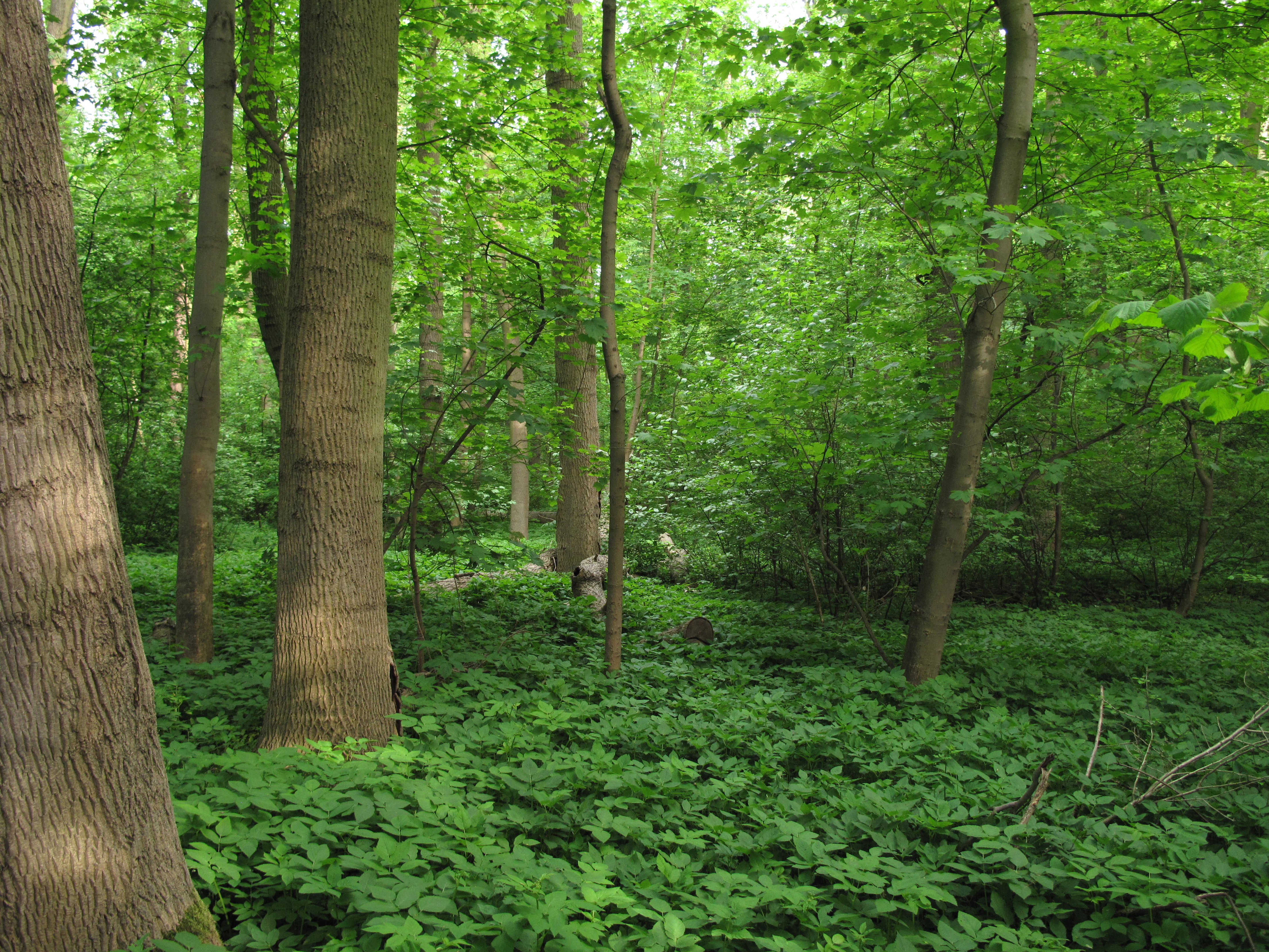
Louzek Nature Reserve flora
Flora within the Louzek Nature Reserve, Litomerice District, Czech Republic.

Dolní Poohří Nature Park history and protected-area timeline

Dolní Poohří Nature Park was formally designated in 2001 by the district authority at Litoměřice, making it a relatively recent regional conservation designation in the Czech Republic. Its establishment reflected growing recognition that the lower Ohře, despite long agricultural pressure on its floodplain, still retained exceptionally valuable assets: free meanders, side arms, and fragments of the original softwood floodplain forest that had largely vanished from the wider Bohemian lowland.

The park's design deliberately built on a pre-existing network of smaller, strictly protected reserves. Sites such as the nature reserves Loužek, Myslivna, and Pístecký les, together with the natural monument Evaňská rokle, were already recognized for their ecological importance before 2001. By enveloping them within a single broader designation, the park created a protective framework that links these fragmented hotspots into a continuous corridor along the river, strengthening both their legal protection and their ecological coherence.

Since its designation, the park's management philosophy has emphasized preserving the river's natural dynamics rather than converting the floodplain to other uses. Maintaining unconstrained meandering, periodic flooding of backwaters, and the continuity of floodplain woodland has been treated as a core conservation objective. In this sense, the post-2001 history of Dolní Poohří is the story of a regional authority attempting to defend a working lowland river system within a heavily cultivated landscape, while gradually integrating its natural and cultural heritage into a single protected landscape framework.

Dolní Poohří Nature Park landscape and geographic character

The landscape of Dolní Poohří is shaped almost entirely by the lower Ohře River. From Křesín in the southwest to Bohušovice nad Ohří in the northeast, the river traces a long, irregular arc across the Bohemian plain, and the park follows that arc for roughly seventeen kilometers. The protected area itself is unusually narrow, only one to three kilometers wide, because its boundaries are drawn tightly around the river's corridor rather than enclosing a broad tract of countryside.

The dominant terrain type is flat alluvial floodplain, broken by the constant curving of the river channel. The Ohře meanders freely here, creating visible features such as the Malá Ohře side arm, the St. Kliment island, and elongated gravel and sand banks. Around the active channel, a network of silted-up dead arms and oxbows lies slightly lower in the floodplain; these depressions fill with water during floods or when groundwater rises, but their muddy bottoms generally prevent tall vegetation from establishing, giving them a distinctive open, marshy character. This rhythm of active channel, damp backwaters, and shallow terraces is the most recognizable physical pattern of the park.

Above the floodplain, the landscape rises onto the broader Dolnooharská tabule, a flat to gently rolling tableland that contributes the Hazmburská tabule and Řipská tabule to the park's northern and southern edges. These transitions occasionally form steeper edges or ravines where smaller streams have cut into the plateau, and one such feature is protected as the Evaňská rokle natural monument. The result is a landscape in which the eye is repeatedly drawn down to the river and its green corridor, framed by flatter cultivated surfaces and crowned by the towers and roofs of small historic towns such as Libochovice, Budyně nad Ohří, and Brozany nad Ohří.

Dolní Poohří Nature Park ecosystems, habitats, and plant life

Ecologically, Dolní Poohří is defined by the surviving fragments of the floodplain forest that once blanketed much of the lower Ohře. Although large-scale clearance and conversion to farmland have reduced similar habitats throughout Central Europe, the park still preserves patches of softwood floodplain woodland along the active river channel and on older, slightly elevated terraces. These relict woodlands are the most important natural asset of the area and the core reason for the park's designation.

Around the woodland, the park includes a range of associated habitats tied to the river's hydrology. Active meanders, gravel bars, and side arms provide open riverine and gravel-bed habitats, while silted-up dead arms and floodplain depressions create damp, marshy environments. These backwaters tend to be species-poor in higher plants because their muddy, frequently disturbed bottoms discourage stable vegetation, but they are rich in specialized aquatic and semi-aquatic communities, and they are precisely the kind of transitional wetland that floodplain forests depend on.

Groundwater plays a central role in shaping these habitats. Because the water table in the floodplain rises and falls with the river, the boundaries between forest, scrub, meadow, and open water shift over time, creating a mosaic of conditions rather than a single uniform habitat. This hydrological dynamism, rather than any single habitat type, is the real ecological backbone of Dolní Poohří. The floodplain's mosaic supports dozens of threatened and protected organisms across plants, invertebrates, fish, and birdlife, and it is this combination of relict woodland, river dynamics, and seasonal flooding that defines the park's ecological identity.

Dolní Poohří Nature Park wildlife and species highlights

The wildlife of Dolní Poohří reflects the diversity of habitats packed into its narrow river corridor. The active river channel and its gravel banks provide habitat for riverine fish species and the invertebrates they depend on, while the surrounding floodplain forest offers shelter for woodland birds, small mammals, and a wide range of insects associated with old-growth hardwood and softwood trees. Where the river spreads into side arms and abandoned channels, calmer water conditions favor amphibians and aquatic invertebrates, and the seasonal flooding of these backwaters creates temporary wetlands attractive to wading birds and other waterfowl.

The park's official designation specifically highlights the presence of dozens of threatened and protected species across multiple groups of organisms, even though it does not list them in detail in public sources. This breadth of protected fauna and flora is one of the park's defining ecological qualities and reflects the value of its mosaic of floodplain woodland, marshy dead arms, and unconstrained river sections. Smaller strictly protected reserves within the park, such as Loužek, Myslivna, Pístecký les, and the natural monument Evaňská rokle, concentrate much of the most sensitive wildlife interest, particularly in their older forest stands and ravine microhabitats.

The cultural-natural character of the park also affects wildlife viewing. Because towns and farmland border the floodplain closely, the transition between inhabited countryside and protected river habitat is short, and woodland and wetland species remain accessible from the surrounding settlements. For visitors interested in birdlife, the mix of mature floodplain forest, open water, and damp meadows makes the park a productive area for observing species characteristic of lowland Bohemian rivers.

Dolní Poohří Nature Park conservation status and protection priorities

Dolní Poohří was established to address a specific conservation gap: although most lowland rivers in Bohemia have been straightened, regulated, or pushed against artificial levees, the lower Ohře still preserves free meanders, side channels, and patches of original floodplain forest. By giving formal regional protection to approximately forty square kilometers of this corridor in 2001, the park aimed to lock in those values before further land-use change could erode them.

A key feature of the conservation strategy is the layered protection system. Within the broader regional designation of the nature park, four smaller protected sites operate under stricter national regimes: the natural monument Evaňská rokle and the nature reserves Loužek, Myslivna, and Pístecký les. This arrangement means that the most ecologically sensitive fragments, including old-growth forest patches and a notable ravine, are shielded by the strongest legal protections, while the surrounding floodplain corridor benefits from coordinated landscape-level planning. The result is a more robust conservation framework than a single designation alone could provide.

The park's importance can also be understood in regional ecological terms. Its floodplain forest fragments, dead arms, and unconstrained meanders represent a habitat complex that has largely disappeared from much of Central Europe, making the park a reference point for the conservation of lowland river landscapes in the Czech Republic. Maintaining the river's natural hydrology, including periodic flooding of backwaters and groundwater-driven wetland formation, is treated as central to this goal. In this way, Dolní Poohří functions less as an isolated reserve and more as a key node in efforts to keep a representative stretch of the Bohemian lowland river ecosystem intact.

Dolní Poohří Nature Park cultural meaning and human context

The cultural landscape around the Ohře River predates the nature park by many centuries and remains an integral part of how the park is experienced. The corridor between Křesín and Bohušovice nad Ohří is anchored by three historic towns: Libochovice, Budyně nad Ohří, and the market town Brozany nad Ohří, each perched slightly above the floodplain on ground that was safer from flooding but close enough to the river to prosper from it.

Libochovice is best known for its chateau, one of the most prominent Renaissance-Baroque residences in the region, while Budyně nad Ohří is dominated by a royal hunting castle of medieval origin that reflects the importance of the surrounding landscape for Bohemian nobility. Brozany nad Ohří adds a smaller Renaissance manor to this ring of residences. Above these secular sites, the Premonstratensian convent at Doksany provides a long-standing religious and cultural anchor, and the hillfort at Levousy and the ruined castle of Šebín add a deeper prehistoric and medieval layer.

This dense cultural ring is unusually tightly integrated with the protected river corridor. Most heritage sites lie within or immediately above the park's boundaries, so visitors moving along the river pass repeatedly between floodplain forest, agricultural land, and inhabited townscape. The park thus functions as a connective tissue linking ecological conservation with a long history of human settlement shaped by the same river that defines its natural character.

Top sights and standout views in Dolní Poohří Nature Park

The strongest features of Dolní Poohří Nature Park converge around its river corridor. The free meanders of the lower Ohře, with their side arms, gravel islands, and oxbow backwaters, form the most distinctive visual and hydrological signature of the park. Around these meanders, relict fragments of softwood floodplain forest provide one of the better-preserved examples of this habitat type in the Czech lowlands, supporting dozens of threatened and protected species.

Within the park, four smaller protected sites focus attention on the most ecologically valuable fragments: the Evaňská rokle natural monument, a steep-sided ravine, and the nature reserves Loužek, Myslivna, and Pístecký les, each anchoring a distinct patch of the original woodland landscape. The historic towns above the floodplain, including Libochovice with its chateau, Budyně nad Ohří with its castle, the Doksany convent, and the Levousy hillfort, complete the park's identity as a combined natural and cultural corridor.

Best time to visit Dolní Poohří Nature Park

The lower Ohře valley experiences a temperate Central European climate, with warmer, drier conditions from late spring through early autumn and colder, often foggier conditions in winter. Late spring and early summer tend to be especially favorable for experiencing the park, when the floodplain forest reaches its fullest leaf cover, the river carries moderate flows, and the meadows and backwaters hold their richest mix of flowers, insects, and birdlife.

Early autumn is also rewarding: the floodplain forest turns color, water levels in the river tend to be lower and more stable, and cooler temperatures make longer walks along the red-marked trail from Doksany through Budyně nad Ohří to Libochovice more comfortable. Winter visits are quieter and reveal the underlying structure of the meanders and dead arms when leaves are absent, but shorter daylight hours and cold weather limit the scope for extended exploration. Across all seasons, the park's relatively narrow geography means that conditions along the whole seventeen-kilometer corridor can change quickly with local weather, especially after heavy rain, when the river may flood some of the backwaters that define the landscape.

Monthly climate preview

Long-term representative monthly temperature and precipitation data patterns

Dolní Poohří Nature Park Climate Normals and Annual Temperature Rhythms

Representative coordinate measurements record monthly mean temperatures ranging from sub-zero winter lows to warm summer maximums alongside varying daily precipitation rates. Examining the full twelve-month profile provides complete historical averages across the entire protected landscape.
Annual mean9 °C
-2 °C20 °C
Jan-2°
Feb-1°
Mar
Apr
May14°
Jun18°
Jul20°
Aug19°
Sep14°
Oct
Nov
Dec-1°
Warmest month
July

19.8 °C

Coolest month
January

-2.3 °C

Wettest month
July

2.4 mm/day

Driest month
February

1 mm/day

Park location guide

Geography guide, regional context, and park location map for Dolní Poohří Nature Park

Dolní Poohří Nature Park park geography, regions, and map view in Czechia

Understand where Dolní Poohří Nature Park sits in Czechia through a broader geographic reading of the surrounding landscape, nearby location context, and its mapped position within the national park landscape.

How Dolní Poohří Nature Park fits into Czechia

Czech Republic is a landlocked Central European country with a population of approximately 10.9 million people. The nation was established as an independent state on January 1, 1993, following the dissolution of Czechoslovakia. Its capital and largest city is Prague, with other major urban centers including Brno, Ostrava, Plzeň, and Liberec.

Wider geography shaping Dolní Poohří Nature Park in Czechia

The Czech Republic is a landlocked country in Central Europe. It is bordered by Germany to the west, Austria to the south, Poland to the northeast, and Slovakia to the southeast. The landscape is predominantly hilly, with the territory covering 78,871 square kilometers.

Map view of Dolní Poohří Nature Park

Use this park location map to pinpoint Dolní Poohří Nature Park in Czechia, understand its exact geographic position, and read its mapped placement within the surrounding landscape more clearly.

Pigeon | © OpenStreetMap contributors

Location context for Dolní Poohří Nature Park

Litoměřice District

Explore floodplain forests, meandering river channels, and protected riparian habitats.

Dolní Poohří Nature Park Photos and Scenery: Visualizing the Protected River Landscape

Visual records illustrate the free meanders of the lower Ohře River and the relict fragments of softwood floodplain forest that define the protected area. Photographic documentation reveals the flat alluvial terrain and marshy oxbow wetlands that shelter threatened species across the Bohemian lowland landscape.

Louzek Nature Reserve flora

Pistecky les Nature Monument

Park atlas

Compare regional river corridors, floodplain forests, and nearby protected natural areas in the Bohemian basin.

Exploring Other Parks Near Dolní Poohří Nature Park and Surrounding Protected Landscapes

Visitors comparing Dolní Poohří Nature Park can browse adjacent protected areas, lowland river corridors, and neighboring forest reserves across the region. Extending the geographic review provides deeper context on Central European lowland ecosystems and regional conservation networks.
Natural monumentLitoměřice District
About 3.9 km away#1 closest

Southeast

Vrbka Natural Monument: Exploring Protected Limestone Habitats and Bohemian Lowland Geography

A rare botanical reserve in the Litoměřice District of the Czech Republic

Vrbka Natural Monument protects a significant 15.5-hectare expanse of warm limestone slopes and dry meadows. This geographic landmark serves as an essential repository for rare orchid species and diverse insect populations, functioning as a representative habitat patch within the intensively cultivated landscapes of the surrounding region.

Area
0.155 km²
Established
2013
IUCN
IV
Relief
Upland
Natural monumentÚstecký kraj
About 4.3 km away#2 closest

Southeast

Na Dlouhé stráni Natural Monument: Regional Protected Area and Botanical Landscape

A conservation-focused look at the Mšenský potok valley slope

Na Dlouhé stráni is a designated natural monument in the Czech Republic, renowned for its concentration of thermophilous grassland flora. This protected area, located near Mšené-lázně, preserves a specific slope habitat that supports declining plant species. The site offers an important look at regional conservation efforts and the mapping of small-scale protected habitats within the diverse Ústecký kraj geography.

Area
0.126 km²
Established
2012
IUCN
IV
Relief
Lowland
Nature reserveUstecky Region
About 6.5 km away#3 closest

West

Vrch Hazmburk Nature Reserve: Geographic Atlas and Protected Landscape Overview

Volcanic terrain and steppe ecosystems in the Ustecky Region

Vrch Hazmburk stands as a notable example of Neovolcanic geology, characterized by steep basalt slopes, frost-shattered cliffs, and a rich mosaic of dry grassland habitats. Located in the Ustecky Region, this protected site preserves a critical transition zone for thermophilic plants and rare invertebrates, offering a clear view of how geological movement and long-term land stability define the Bohemian lowland landscape.

Area
0.604 km²
Established
2011
IUCN
IV
Relief
Mountain
Natural monumentÚstecký kraj
About 10 km away#4 closest

Southwest

V hlubokém Natural Monument: Protected Calcareous Landscapes and Terrain in Ústecký kraj

A study of rare sesleria grasslands and opuka slope geography

V hlubokém serves as a significant protected site in the Czech Republic, encompassing twenty hectares of hillside defined by soft calcareous opuka rock. This natural monument is recognized for its rare sesleria grasslands and thermophilic plant assemblages that contrast with the surrounding woodland. The protected area forms a critical link in the broader geography of the Débeř valley, offering a clear example of localized botanical diversity supported by unique alkaline substrate conditions.

Area
0.202 km²
Established
1947
IUCN
III
Relief
Upland
Natural monumentÚstecký kraj
About 13 km away#5 closest

North

Radobýl Natural Monument: Basalt Formations and Volcanic Geography in Ústecký kraj

A protected volcanic landmark with steppe ecosystems and ridge views.

Radobýl stands as a distinctive volcanic remnant in the Ústecký kraj, featuring profound columnar basalt jointing and frost-weathered cliffs. This protected natural monument shelters rare dry grassland habitats and rocky terrain, while offering expansive views across the Litoměřice basin and the surrounding Bohemian landscape.

Area
0.063 km²
Established
1966
IUCN
IV
Relief
Mountain
Natural monumentStředočeský kraj
About 20 km away#6 closest

South

Slánská hora Natural Monument: Volcanic Geography and Protected Hilltop Terrain in Central Bohemia

Detailed geological mapping of a Tertiary volcanic outlier and historic monument

Slánská hora functions as a significant geological landmark where basaltic vent remnants meet centuries of human history. This natural monument offers a window into the volcanic processes of the region through exposed columnar basalt and rock fissures. The site serves as a vital protected area, balancing remnants of warm-loving steppe vegetation and deciduous forest with the legacy of former quarries and ancient archaeological strata atop the Slaný ridge.

Area
0.022 km²
Established
1998
IUCN
III
Relief
Mountain
Natural monumentStředočeský kraj
About 20 km away#7 closest

Southeast

Veltrusy Natural Monument: Protected Woodland and Historic Park Geography in Středočeský kraj

English-style designed landscapes and floodplain ecological habitats.

Veltrusy Natural Monument is a protected area located on the right bank of the Vltava River, defined by its horseshoe-shaped layout and mosaic of oak-beech woodlands. The site represents a rare intersection of cultural heritage and nature conservation, preserving veteran trees that support significant invertebrate populations. Its geography consists of gently undulating floodplain terrain shaped by the Mlýnský potok, historic avenues, and managed meadows.

Area
2.555 km²
Established
2013
IUCN
III
Relief
Lowland
Natural monumentStředočeský kraj
About 20 km away#8 closest

Southwest

Smradovna Natural Monument: Geography and Protected Habitats in Central Bohemia

A protected stream valley system within the Stredocesky kraj region.

Smradovna preserves a unique concentration of lowland habitats, including calcareous beech forests and rare alkaline fens. This protected natural monument, located near Bilichov, is defined by its characteristic travertine springs and continuous stream-corridor ecosystem. Gain insight into the regional geography and botanical significance of this tightly knit protected landscape through our structured mapping and data.

Area
1.556 km²
Established
2014
IUCN
IV
Relief
Upland

Common questions about visiting, size, designation, and location context for Dolní Poohří Nature Park

Dolní Poohří Nature Park FAQs for park facts, access, geography, and protected area context

Find quick answers about Dolní Poohří Nature Park, including protected-area facts, park geography, trail and visitor context, and how the park fits into its surrounding country and regional landscape.
MoriAtlas Explorer

Continue Your Protected Areas Search Across the Global Atlas

Deepen your exploration by continuing the structured search for national parks and protected areas worldwide. Utilize the comprehensive filtering capabilities to compare different conservation landscapes and refine your understanding of global park geography. Discover more about the distribution and characteristics of protected natural areas.

Global natural geography