

Mori Atlas logo
Nature reserveDubringer Moor

Mapped boundaries and natural terrain of the largest surviving moorland complex in Upper Lusatia

Dubringer Moor: A Significant Nature Reserve within the Saxony Regional Geography and Atlas

(Naturschutzgebiet Dubringer Moor)

Dubringer Moor stands as an extensive nature reserve in northern Saxony, Germany, representing the largest intact through-flow moorland complex of the Upper Lusatia region. This protected landscape encompasses a complex mosaic of wet forests, species-rich grasslands, fish ponds, and various mire habitats that provide a critical refuge for wetland-dependent species. The geographic setting features a shallow glacial basin defined by terminal moraine ridges, creating a distinct hydrological system that sustains these fragile peatland ecosystems within the European Natura 2000 network.

moorlandpeatlandfenbogwet meadowsfish ponds
A flat-design, stylized digital illustration depicting a river flowing through a forested valley toward a central waterfall against a backdrop of mountains under a sunlit sky.

Dubringer Moor

Nature reserve

Park overview

Structured park overview, official facts, and landscape profile for Dubringer Moor

Dubringer Moor park facts, protected area profile, and essential visitor context

Review the core facts for Dubringer Moor, including designation, size, terrain, visitor scale, habitats, and operating context in one park-focused overview.

About Dubringer Moor

Dubringer Moor is a substantial inland nature reserve in the Bautzen district of Saxony, situated roughly between the towns of Hoyerswerda and Wittichenau. Its boundaries are defined by the rural roads and trails around the villages of Dubring, Bröthen/Michalken and Bernsdorf, by the forested ridge of the Gerichtsberg in the west, and by the old, uncanalised course of the Schwarze Elster river in the east. Within this frame lies a richly patterned wetland landscape shaped by ice-age geology, monastic land management and centuries of fish-pond culture.

The reserve's geographic identity is closely tied to the end moraines left by the Elster glaciation. Three terminal moraine ridges form a horseshoe around the site, trapping water inside and allowing peat to develop over roughly 10,000 years into a deposit up to six metres thick. This origin gives the moor its characteristic through-flow structure: water from surrounding higher ground flows gradually through the basin toward the Schwarze Elster, creating the saturated conditions that define intermediate bogs, fens and the open heath-mire within the reserve.

Land use within and around the reserve reflects a long and layered human history. Much of the area, including the ponds, has belonged since 1248 to Kloster St. Marienstern in Panschwitz-Kuckau, and the principal western forest is still known as the St. Mariensterner Klosterforst. The southern part of the moor also holds the remains of a prehistoric refuge castle, the Versunkenes Schloss, attributed to the Billendorfer culture. In the twentieth century, parts of the peat and underlying lignite were exploited to supply local brickworks, especially after the Second World War, and later plans for large-scale open-cast lignite mining were abandoned following German reunification.

Today Dubringer Moor is a unified conservation landscape combining protected forest, traditional fish ponds, open cotton-grass meadows and orchid meadows, with active management by NABU and local farmers under conservation contracts. Its integration into the European Natura 2000 framework, parallel designation as a Saxon nature reserve and recognition as a Special Protection Area for birds underline its role as a reference site for lowland mire and pond conservation in eastern Germany.

Quick facts and research context for Dubringer Moor

Dubringer Moor is a nature reserve (Naturschutzgebiet, official code D78) located in northern Saxony across the municipalities of Bernsdorf, Hoyerswerda and Wittichenau. It was officially designated on 7 March 1995 and covers an area of about 17.11 square kilometres (approx. 1,711 hectares), making it one of the largest nature reserves in Saxony.

The protected area sits within the Oberlausitz region along the original course of the Schwarze Elster, between elevations of about 118 and 150 metres above sea level. It is classified as an IUCN Category IV Habitat/Species Management Area and forms part of the EU Natura 2000 network through both a Habitats Directive site (DE-4550-301) and a Special Protection Area for birds (DE-4550-451).

Protection and recognition

Documented terrestrial protection scope, management framework, and Natura 2000 recognition sources

Dubringer Moor Protection Status and International Recognition Data

Terrestrial protection status, management scope, and official Natura 2000 recognition sources provide structured context for Dubringer Moor. Documented designation records outline the regulatory framework and international recognition parameters associated with the protected area.
Park context

Deeper park guide and search-rich context for Dubringer Moor

Dubringer Moor history, landscape, wildlife, and travel context

Explore Dubringer Moor through its history, landscape character, ecosystems, wildlife, conservation priorities, cultural context, and seasonal travel timing in a structured park guide built for atlas discovery and search intent.

Why Dubringer Moor stands out

Dubringer Moor is best known as the largest surviving moor complex of Upper Lusatia, with a six-metre-thick peat layer that has accumulated since the end of the Elster glaciation. The reserve is particularly valued for its through-flow mire structure, which combines intermediate bog, fen and a regenerated open heath-mire, and for its cotton-grass meadows and orchid-rich wet grasslands. It is equally renowned for its importance as a breeding area for rare and threatened wetland birds recorded on the Saxon Red List, including species such as common crane, white-tailed eagle, black kite, hen harrier, northern lapwing, common snipe, bittern and hobby. The combination of old fish-pond culture, open water, mire and forest creates a rare continuity of habitat that supports herons, otters, amphibians and the recolonising wolf.
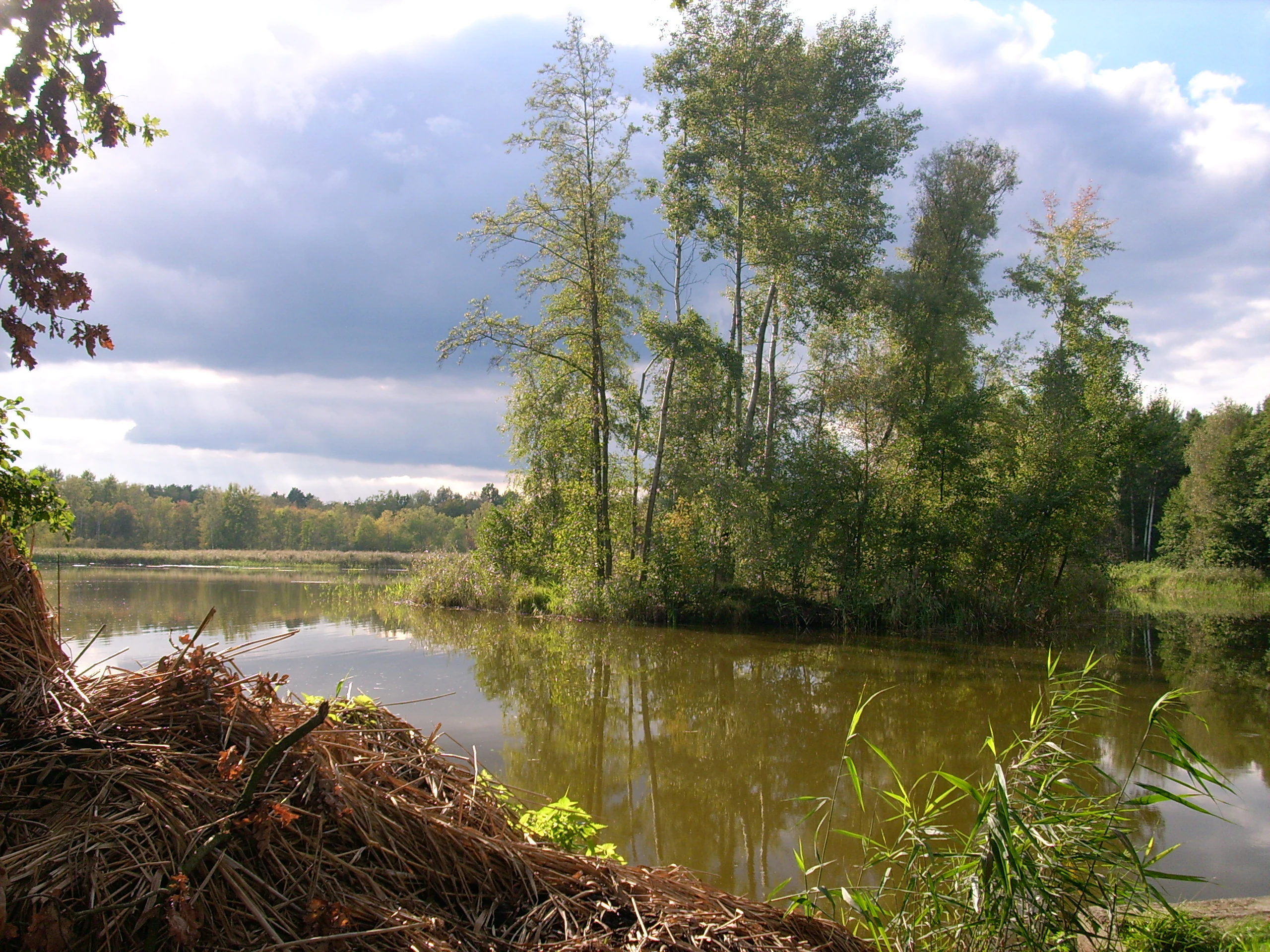
A calm, reflective pond with a small, tree-covered island in the center, surrounded by forest and wetland vegetation under a cloudy sky.
Wusteteich pond situated within the wetlands of Dubringer Moor.

Dubringer Moor history and protected-area timeline

The natural framework of the moor was laid down during the Elster glaciation, when three end moraines formed a horseshoe around the basin and allowed peat to accumulate over about ten thousand years into a layer up to six metres thick. The resulting through-flow moor, fens and open heath-mire represent the largest such complex still preserved in the Upper Lusatia region.

Human history in the area is unusually deep for a lowland wetland. The southern part of the moor contains the earthworks known as the Versunkenes Schloss, a refuge castle of the prehistoric Billendorfer culture, while the ponds and much of the surrounding land have belonged to Kloster St. Marienstern in Panschwitz-Kuckau since the monastery was founded in 1248. The western forested core of the reserve is still referred to as the St. Mariensterner Klosterforst in recognition of this long monastic stewardship.

During the twentieth century the peat body and the lignite deposits beneath it were exploited in several phases, including intensive industrial extraction after the Second World War when local briquette factories had been dismantled as reparations and alternative fuel sources were required. Open-cast lignite mining across broader stretches of the Lusatian landscape also threatened the hydrology of the moor through falling groundwater levels. Proposals to extract the brown coal beneath the reserve itself, which had been planned from around 2010, were abandoned after German reunification.

The site was formally protected as the Naturschutzgebiet Dubringer Moor on 7 March 1995 under the official code D78. It was later incorporated into the European Natura 2000 network: a Habitats Directive site (FFH-Gebiet, DE-4550-301) has existed almost coincident with the nature reserve since 2011, and the area is also designated as a Special Protection Area (Europäisches Vogelschutzgebiet) for wild birds under the code DE-4550-451, covering the reserve plus additional adjoining open land to the east.

Dubringer Moor landscape and geographic character

The reserve occupies a shallow glacial basin framed by three terminal moraine ridges of the Elster glaciation, whose horseshoe shape opens to the north. This bowl-shaped setting funnels fine sediments and slow-moving surface water, producing the saturated ground conditions that sustain the moor and the surrounding wetlands.

Topographically the area is remarkably flat, with elevations ranging from roughly 118 to 150 metres above sea level and an average of about 122 metres. The western edge rises to between 130 and 134 metres near the Gerichtsberg ridge, while the southern boundary lies near 127 metres; from there the surface drains gently eastward toward the natural, uncanalised course of the Schwarze Elster at around 120 metres, creating the gradient that defines the through-flow character of the whole system.

Within this frame the landscape alternates between dense coniferous and mixed forest of the St. Mariensterner Klosterforst, open wet meadows dominated by cotton-grass, and a network of fish ponds and small standing waters such as the Wusteteich and the Mittelteich. Just west of the reserve runs a regional watershed, the Zeißholzer Hochfläche, which separates the Schwarze Elster drainage from that of the Spree. The climate is transitional, with an annual mean temperature of about 8.6 degrees Celsius and around 635 millimetres of precipitation, shaped by frequent alternations between maritime and continental influences.
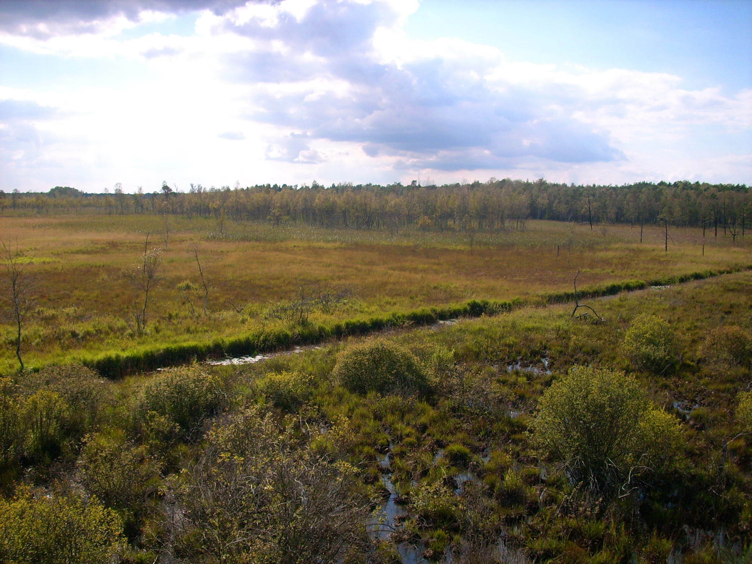
An elevated, wide-angle view of the Dubringer Moor peatland landscape showing patches of shrubs, grasses, and small drainage channels beneath a cloudy sky.
A wide view of the marshy wetlands within Dubringer Moor.

Dubringer Moor ecosystems, habitats, and plant life

Ecologically, Dubringer Moor is a through-flow moor (Durchströmungsmoor) system built from a mosaic of intermediate bog, fen and an open, regenerated heath-mire. The basin acts as a natural sponge: water arriving from the surrounding moraines percolates slowly through the peat body toward the Schwarze Elster, continually recharging the saturated zones that maintain the bog vegetation. This structure makes the site the largest intact moor complex remaining in the Upper Lusatia.

The vegetation of the open areas is dominated by extensive cotton-grass meadows (Wollgraswiesen), which in places cover non-managed stretches of roughly 300 hectares and create the striking white-flecked appearance visible from the observation tower near Teichhaus Neudorf. In the wetter margins and on traditional grasslands, orchid-rich meadows have been maintained through cooperative care contracts with local farmers, supported by the Saxon nature conservation authorities, to preserve species such as spotted orchid, broad-leaved helleborine and related bog flora.

Around the open wetland, the closed forests of the Klosterforst and the pond fringes add coniferous woodland, alder carr and reed-fringed shorelines to the habitat mix. The result is a coherent and functionally connected gradient from open water through mire and wet meadow to dry forest, providing ecological continuity that is unusually well preserved for a lowland Central European landscape.

Dubringer Moor wildlife and species highlights

The reserve's combination of open water, mire and forest gives it an outstanding significance for birds, and it is a key Saxony breeding site for species on the regional Red List. Nesting threatened species documented at the site include hobby, common snipe, common kingfisher, grey-headed woodpecker, woodlark, northern lapwing, little crake, common crane, northern shoveler, red-backed shrike, great grey shrike, bittern, marsh harrier, red and black kite, Savi's warbler, black woodpecker, white-tailed eagle, barred warbler, spotted crake, wryneck, honey buzzard and European nightjar. Although the local grey heron colony near the Energiefabrik Knappenrode feeds intensively in the moor, the birds themselves do not breed there.

Fish continue to be a working part of the landscape. The ponds are still used mainly for carp farming, and several former fish ponds have been left unmanaged to develop into amphibian-rich wetland habitats. These water bodies host alpine, smooth and great crested newts, and the amphibian-rich ponds in turn support a healthy otter population. The reserve also sustains raccoon, American mink and, increasingly, grey wolf, which have recolonised the wider forest landscape. Reptiles typical of heathland conditions, including lizards, slow-worm and adder, complete the wetland and mire fauna.

Dubringer Moor conservation status and protection priorities

Dubringer Moor is protected at multiple administrative levels and has its conservation importance formally recognised by both national and European instruments of nature protection. It was designated as a Saxon nature reserve (Naturschutzgebiet, code D78) on 7 March 1995, and is classified as an IUCN Category IV Habitat/Species Management Area, with management aimed at preserving specific habitats and species rather than excluding all human activity.

At the European level, the site is integrated into the Natura 2000 network as a Habitats Directive site (FFH-Gebiet, DE-4550-301) since 2011 and as a Special Protection Area for wild birds (Europäisches Vogelschutzgebiet, DE-4550-451), which together with the nature reserve gives the moor a coordinated legal protection across habitat and species policy of the European Union. These designations reflect the area's particular value for threatened breeding birds and for peatland habitats that have become rare across Central Europe.

The hydrology of the reserve is the central conservation concern. Because a moor can only survive if its water catchment is preserved, the protected area is tightly linked to the management of regional land use, including the surrounding former open-cast lignite mines, which continue to affect groundwater levels. Active management carried out by NABU and contracted local farmers, including the maintenance of orchid meadows and the protection of cotton-grass swards, helps to keep the open mire habitat from being lost to scrub or to drying-out linked to past peat extraction.

Dubringer Moor cultural meaning and human context

The cultural story of Dubringer Moor is built on monastic stewardship and prehistoric settlement. The ponds and the western forest have belonged to Kloster St. Marienstern in Panschwitz-Kuckau since 1248, and the principal forest block inside the reserve is still known as the St. Mariensterner Klosterforst in memory of that long monastic landholding, which helped to preserve the area as a working cultural landscape.

Deeper layers of cultural memory lie in the earthworks of the Versunkenes Schloss, a refuge castle of the prehistoric Billendorfer culture preserved in the southern section of the moor. The site reflects a long-running pattern of human adaptation to wet, lowland terrain, ranging from prehistoric defensive use to medieval economic use of fish ponds and forests.

Modern cultural engagement with the moor centres on nature-based recreation and environmental education. The area is crossed by themed cycle routes including the Froschradweg and the Krabat-rundweg, and an observation tower inaugurated on 2 July 2009 by the Saxon Minister-President offers views across the cotton-grass meadows. Regular guided walks by the local NABU chapter connect visitors with the moor as both working countryside and protected natural heritage.

Top sights and standout views in Dubringer Moor

Three qualities especially define Dubringer Moor. First, it is the largest surviving moorland complex of the Upper Lusatia, with a peat layer up to six metres deep and a through-flow hydrology that links fen, intermediate bog and a regenerated open heath-mire. Second, the integration of centuries-old fish-pond culture with wet forest and open mire creates a habitat mosaic that supports threatened wetland birds such as common crane, white-tailed eagle and bittern, alongside amphibians, otters and the recolonising wolf. Third, the reserve's parallel designations as a Saxon nature reserve, an EU Habitats Directive site and a Special Protection Area for birds place it firmly within the European Natura 2000 conservation network.

Best time to visit Dubringer Moor

Dubringer Moor is at its most photogenic in late spring and high summer, when the cotton-grass meadows turn white with fruiting heads across roughly 300 hectares of non-managed open mire, and when the orchid-rich wet grasslands reached through cooperative management with local farmers are in bloom. Summer is also the season of regular guided NABU walks through the reserve and the best time to use the observation tower between Teichhaus Neudorf and the Michalken district of Hoyerswerda.

Wildlife viewing peaks in the warmer months as well, when breeding wetland birds, amphibians in the unmanaged ponds and dragonflies over the standing waters are most active. The transitional climate of the region, shaped by both maritime and continental influences, tends to give relatively mild springs and warm summers, although weather in any single visit can vary, so flexible timing is usually preferable to fixed plans.

Monthly climate preview

Long-term representative records tracking monthly temperature and precipitation variation across Saxony

Dubringer Moor Climate Normals: Annual Temperature and Precipitation Rhythms

Historical data collected from a representative coordinate demonstrates wide annual temperature swings alongside steady monthly precipitation patterns. Reviewing comprehensive monthly climate normals reveals deeper insight into long-term environmental conditions across the protected terrain.
Annual mean9 °C
-1 °C20 °C
Jan-1°
Feb
Mar
Apr
May14°
Jun18°
Jul20°
Aug20°
Sep15°
Oct
Nov
Dec
Warmest month
July

20.4 °C

Coolest month
January

-1.1 °C

Wettest month
July

2.7 mm/day

Driest month
April

1.2 mm/day

Park location guide

Geography guide, regional context, and park location map for Dubringer Moor

Dubringer Moor park geography, regions, and map view in Germany

Understand where Dubringer Moor sits in Germany through a broader geographic reading of the surrounding landscape, nearby location context, and its mapped position within the national park landscape.

How Dubringer Moor fits into Germany

Germany is a federal republic in Western and Central Europe with a population of over 83 million across sixteen constituent states. It is Europe's largest economy by nominal GDP and a major global exporter and importer. The capital is Berlin, and the country borders Denmark, Poland, Czech Republic, Austria, Switzerland, France, Luxembourg, Belgium, and the Netherlands.

Wider geography shaping Dubringer Moor in Germany

Germany is located in Western and Central Europe, spanning 357,022 km². It borders Denmark to the north, Poland and the Czech Republic to the east, Austria and Switzerland to the south, and France, Luxembourg, Belgium, and the Netherlands to the west. The country has coastlines on the Baltic Sea and North Sea to the north, with the Alps located in the southern region.

Map view of Dubringer Moor

Use this park location map to pinpoint Dubringer Moor in Germany, understand its exact geographic position, and read its mapped placement within the surrounding landscape more clearly.

Pigeon | © OpenStreetMap contributors

Location context for Dubringer Moor

Saxony
Recorded earthquake history

Explore the Historical Earthquake Records for Dubringer Moor

Access a structured collection of recorded seismic events associated by proximity to the Dubringer Moor nature reserve. Use these historical records to trace regional activity patterns alongside event magnitudes and distances, presented through the MoriAtlas geographic database for clarity.

Dubringer Moor Earthquake History

Catalogued events

5 events

Strongest magnitude

Magnitude 3.7

Most recent event

Aug 4, 1998

This history includes earthquakes recorded inside the park or within 50 km of its borders

Explore protected area photography documenting glacial basin terrain, wet forests, and fragile peatland ecosystems.

Dubringer Moor Photos and Landscape Scenery: Visualising Upper Lusatia Mire Habitats

Visual records capture the distinctive character of Dubringer Moor through detailed imagery of cotton-grass meadows, open fens, and interconnected fish ponds. Photographic documentation reveals the underlying terrain and diverse wetland habitats that define this protected nature reserve in Saxony.

A calm, reflective pond with a small, tree-covered island in the center, surrounded by forest and wetland vegetation under a cloudy sky.

A wide view of a green, open peatland meadow seen from under the wooden roof of an observation deck, with white cotton grass visible in the foreground.

An elevated, wide-angle view of the Dubringer Moor peatland landscape showing patches of shrubs, grasses, and small drainage channels beneath a cloudy sky.

Park atlas

Compare nearby protected areas and connected regional wetland habitats

Exploring Parks Near Dubringer Moor and Surrounding Protected Landscapes

Visitors exploring Dubringer Moor can continue discovering other protected areas across the surrounding region. Comparing adjacent wetland habitats and glacial landscapes provides a broader geographic perspective on regional conservation.
Nature reserveBrandenburg
About 14 km away#1 closest

Northwest

Sorno-Rosendorfer-Buchten Nature Reserve: Geographic Overview and Protected Landscape Maps

Lusatian lake district protected area and post-mining restoration terrain.

This nature reserve in Brandenburg provides a deep look at the ecological evolution of post-industrial land. The area features a mix of flooded mining pits, sheltered bays, and nutrient-poor sandy soils that support pioneering plant communities and remnant forest patches. Explore the mapped boundaries and the specific geographic context of this unique German protected landscape.

Area
10.9 km²
Established
2014
IUCN
IV
Nature reserveBautzen
22 km away#2 closest

Southeast

Spreeniederung Malschwitz Nature Reserve and Riverine Floodplain Geography

Protected riparian landscapes in the Bautzen district

Spreeniederung Malschwitz represents a significant protected floodplain along the Spree river. This nature reserve provides crucial habitats through its complex network of traditional fishponds, oxbow lakes, and old-growth forests, serving as a key staging site for migratory waterfowl within the Upper Lusatian landscape.

Area
18.57 km²
Established
2002
Nature reserveSachsen
25 km away#3 closest

Northeast

Altes Schleifer Teichgelände: Geographic Context of the Sachsen Nature Reserve

Wetland habitats and protected heathland in Upper Lusatia

Altes Schleifer Teichgelände represents a key protected area where the Struga stream feeds a network of historic ponds and damp meadows. Situated at the edge of the Trebendorf plateau, this nature reserve offers a study in landscape restoration, balancing diverse birch mire forests with orchid-rich grasslands in the heart of the Muskauer Heide.

Area
0.676 km²
Established
1981
IUCN
IV
Relief
Lowland
Protected areaSaxony
26 km away#4 closest

Northeast

Trebendorfer Tiergarten: Protected Woodland and Natura 2000 Habitat in Saxony

Mapped forest terrain in the Landkreis Görlitz

Trebendorfer Tiergarten encompasses approximately 201 hectares of inland forest, reflecting the habitat conservation priorities of the European Union. Located in eastern Saxony, the reserve features clearly defined boundaries shaped by historic infrastructure and forestry, offering a precise case study of protected land within the wider Lusatian heath and pond landscape.

Area
2.01 km²
Established
1961
Relief
Lowland
Climate
Temperate
Nature reserveBrandenburg
27 km away#5 closest

North

Koselmühlenfließ Nature Reserve: A Protected Stream Valley in the Brandenburg Region

Geographic overview of the Lusatian land ridge brook habitat

Koselmühlenfließ protects a largely natural lowland stream and its floodplain corridor set amidst the undulating landscapes of the Lusatian land ridge. This nature reserve in the Spree-Neisse district represents a focused contribution to the Brandenburg conservation network, highlighting the value of small-scale brook environments in northeast Germany.

Area
1.12 km²
Established
2006
IUCN
IV
Relief
Lowland
Nature reserveBrandenburg
32 km away#6 closest

West

Welkteich Nature Reserve: Brandenburg Industrial Legacy and Protected Habitat Mapping

Mapping a unique mosaic of post-mining terrain and historic pond systems

Located in the district of Oberspreewald-Lausitz, Welkteich represents a distinct example of how industrial-era mining scars and artificial ridges can evolve into protected nature reserves. The site serves as a vital ecological corridor, featuring a dense interspersion of aquatic basins, forest patches, and dry ground that provides a sanctuary for diverse species within the broader Brandenburg landscape.

Area
1.13 km²
Established
1981
IUCN
IV
Relief
Lowland
Nature reserveBrandenburg
32 km away#7 closest

North

Teichlandschaft Buchwäldchen-Muckwar: Protected Pond Landscape and Forest Mosaic in Brandenburg

Exploring the historic hydrology and forest restoration of Lusatia.

This nature reserve in Brandenburg features a centuries-old system of fishponds connected by ditches, creating a rare Lusatian aquatic landscape. The protected area consists of a mosaic of wet meadows, alder swamps, and evolving forest stands that are undergoing active conversion to native broadleaf species. Discover the geography, mapped pond chains, and ecological character of this vital protected site within the Oberspreewald-Lausitz district.

Area
0.953 km²
Established
1997
IUCN
IV
Relief
Lowland
A pale, soft watercolor painting depicting a small arched bridge crossing a gentle stream within a rolling green valley.
Protected landscapeSaxony
About 32 km away#8 closest

Southwest

Seifersdorfer Tal Protected Landscape and Cultural Heritage in Saxony

A historic garden monument and river valley ecosystem

The Seifersdorfer Tal is a protected landscape defining the Große Röder valley. Beyond its cultural status as one of Germany's earliest English-style landscape gardens, the area serves as a vital riverine corridor and nature reserve. The terrain offers a unique blend of rocky outcrops, wooded slopes, and meadows linked by historic footpaths and 18th-century allegorical monuments.

Area
2.88 km²
Established
1960
Relief
Upland
Climate
Temperate

Common questions about visiting, size, designation, and location context for Dubringer Moor

Dubringer Moor FAQs for park facts, access, geography, and protected area context

Find quick answers about Dubringer Moor, including protected-area facts, park geography, trail and visitor context, and how the park fits into its surrounding country and regional landscape.
MoriAtlas Explorer

Continue Your Protected Areas Search Across the Global Atlas

Deepen your exploration by continuing the structured search for national parks and protected areas worldwide. Utilize the comprehensive filtering capabilities to compare different conservation landscapes and refine your understanding of global park geography. Discover more about the distribution and characteristics of protected natural areas.

Global natural geography