
Mori Atlas logo
Nature reserveDüllhamm

Examining the ecological diversity and transitional terrain of this Bremerhaven refuge.

Düllhamm Nature Reserve in Bremen: A Compact Mosaic of Protected Lowland Landscapes

(Naturschutzgebiet Düllhamm)

Düllhamm stands as a significant nature reserve within Bremerhaven, preserving a rare, compact mosaic of habitats in an urbanized region. The site captures a distinct transition between dry oak-birch woodland and saturated moor-like heath, reed beds, and wet grassland. This protected area serves as an essential microcosm of lowland northwest German geography, offering clear insights into the interplay of forest and marshland ecosystems within the Bremen state boundaries.

nature reservewet woodlandoak-birch forestwet grasslandmoor heathreed beds
A minimalist flat illustration showing a landscape with a river flowing from a waterfall between high cliffs; pine trees and grassy plains frame the water, set under a sunlit sky.

Düllhamm

Nature reserve

Park overview

Structured park overview, official facts, and landscape profile for Düllhamm

Düllhamm park facts, protected area profile, and essential visitor context

Review the core facts for Düllhamm, including designation, size, terrain, visitor scale, habitats, and operating context in one park-focused overview.

About Düllhamm

Düllhamm is a small but ecologically rich nature reserve in the Surheide district of Bremerhaven, in the German state of Bremen. Although it covers only 4.3 hectares, the reserve is notable for condensing a wide range of lowland habitats into a very compact footprint. Designated on 13 July 1984 and administered by the city of Bremerhaven, it forms one of the protected natural area cores within the larger Surheide-Süd/Ahnthammsmoor landscape protection area, which surrounds it on the land side. To the south, the reserve borders the Bremerhaven–Buxtehude railway line, marking a clear boundary between the protected habitat and the surrounding transport infrastructure.

The western half of the reserve is dominated by oak-birch woodland (Eichen-Birkenwald) with a well-developed understory of herbaceous plants and shrubs. This woodland provides the drier, structurally more complex habitat of the site, with a layered vegetation structure that supports woodland species adapted to sandy, acidic soils typical of the region. Within the wooded area, smaller pockets of swampy ground, reed beds, and willow scrub create microhabitats that increase the reserve's ecological complexity.

The eastern side of Düllhamm shifts toward open, wet, and increasingly boggy terrain. Here, moist to wet grassland merges into moor-like heath, dotted with characteristic grasses such as blue moor-grass and purple moor-grass. Tall-herb communities and reed beds, including stands of common reed, add further structural diversity and underline the transitional nature of the landscape. Together, these habitats create a small but representative sample of the wetland-influenced lowland ecosystems that once defined much of the Bremen area and that have become increasingly fragmented under urban and industrial pressure.

Quick facts and research context for Düllhamm

Düllhamm is a designated nature reserve (Naturschutzgebiet) in southern Bremerhaven, located in the Surheide district of the Free Hanseatic City of Bremen. The reserve covers approximately 4.3 hectares and is registered under number 2 in Bremerhaven's nature protection register. It has been protected since 13 July 1984, with the city of Bremerhaven acting as the responsible nature protection authority.

It lies within the larger landscape protection area (Landschaftsschutzgebiet) of Surheide-Süd/Ahnthammsmoor and is bordered to the south by the Bremerhaven–Buxtehude railway line. Ecologically, the reserve combines oak-birch woodland on its western side with wet grassland and boggy heath on its eastern side, along with embedded small swamps, reed beds, and willow thickets. It is one of several small protected sites that together represent the surviving natural landscape character of the Bremen region.

Protection and recognition

Examine the official terrestrial protection scope and recorded designation data for Düllhamm.

Düllhamm Protection Status and Documented Protected Area Record

Terrestrial protection records for Düllhamm outline the core management scope and administrative designation details. Reference data catalogs official conservation boundaries and associated protection frameworks without relying on external assumptions.

Protection details

Protection scope
Terrestrial
Transboundary protection
No
WDPA ID
162817
Park context

Deeper park guide and search-rich context for Düllhamm

Düllhamm history, landscape, wildlife, and travel context

Explore Düllhamm through its history, landscape character, ecosystems, wildlife, conservation priorities, cultural context, and seasonal travel timing in a structured park guide built for atlas discovery and search intent.

Why Düllhamm stands out

Düllhamm is best known for being a remarkably compact nature reserve that packs a diverse mosaic of habitats into a very small area within an otherwise heavily developed urban and industrial region. The site is defined by its juxtaposition of dry oak-birch forest with wet and boggy habitats, including species-rich reed beds and moor-like heath patches. The reserve is also valued as part of the wider Surheide-Süd/Ahnthammsmoor landscape protection area, where it serves as a core refuge for native lowland vegetation types that have largely disappeared from surrounding Bremerhaven. Its conservation significance lies in protecting a transitional landscape where forest, marsh, wet meadow, and heath come together in close proximity.
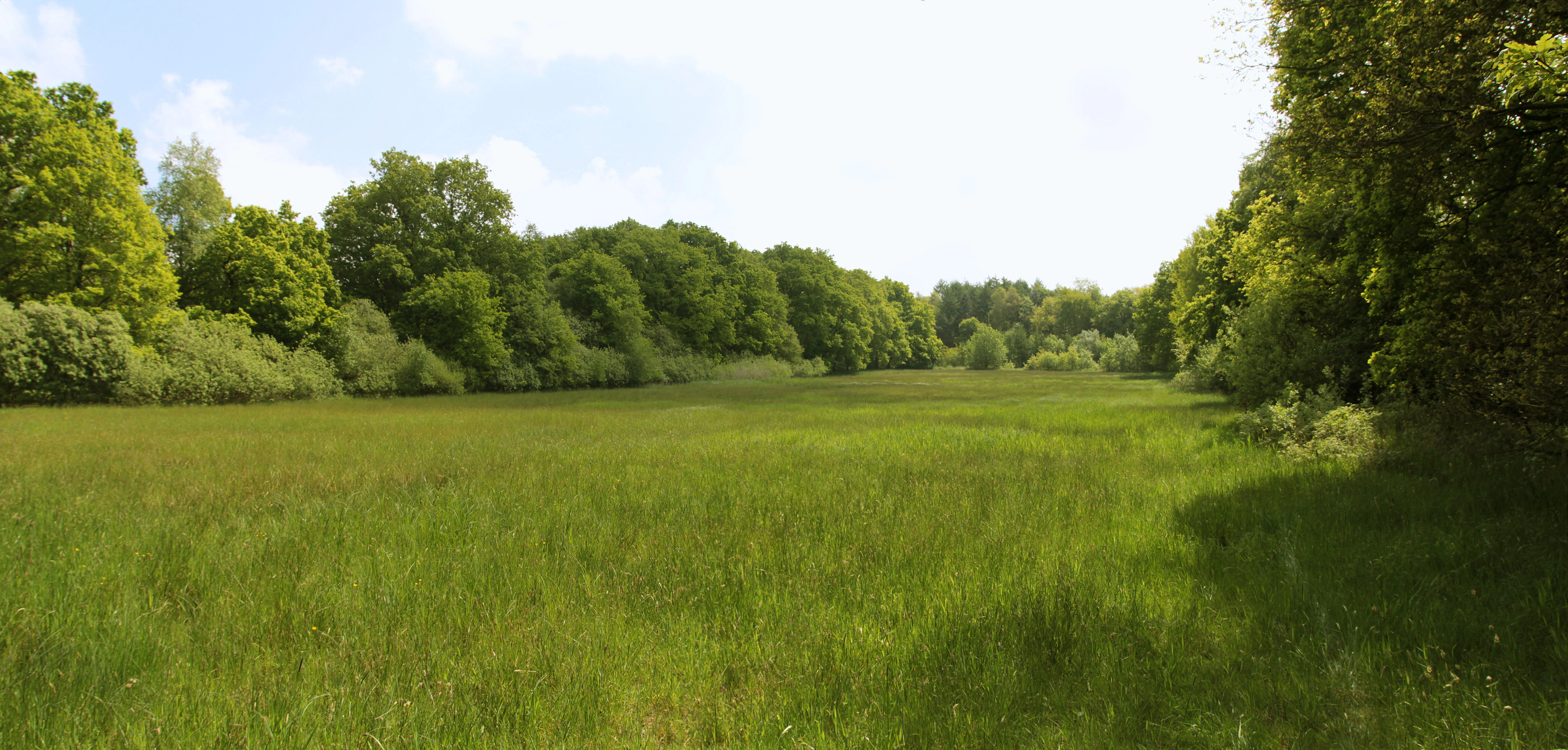
A wide, horizontal view of a lush green meadow surrounded by dense trees under a bright sky.
A view of the open grasslands and surrounding forest in the Düllhamm nature reserve.

Düllhamm history and protected-area timeline

Düllhamm was formally designated as a nature reserve (Naturschutzgebiet) on 13 July 1984, with the city of Bremerhaven taking on the role of responsible nature protection authority. The site was entered into Bremerhaven's nature protection register as number 2, formalizing its protected status among the small set of natural areas preserved within the city.

Its establishment coincided with the broader designation, also in July 1984, of the surrounding Surheide-Süd/Ahnthammsmoor landscape protection area, which provides a larger buffer of protected countryside around the reserve. This dual-level protection reflects the standard German approach of combining strict nature reserves with broader landscape protection zones to safeguard both core habitats and their wider ecological context.

The reserve's relatively late formal protection reflects the broader late-twentieth-century recognition of small, fragmented habitats within and around German cities. Düllhamm represents one in a series of small protected areas across Bremen and Bremerhaven that were formally identified as worthy of conservation status during this period, preserving pockets of natural landscape that might otherwise have been absorbed by urban expansion.

Düllhamm landscape and geographic character

The landscape of Düllhamm is shaped by the contrast between dry forest land and open wet or boggy terrain, squeezed into a compact area of just a few hectares. On its western side, the reserve is defined by oak-birch woodland growing on what are likely sandy, relatively well-drained soils. The trees form a closed canopy, beneath which a varied layer of shrubs and ground vegetation thrives, giving the woodland a structurally rich character for its size.

To the east, the terrain becomes noticeably lower and wetter. Damp to permanently saturated grassland grades into moor-like heath, where typical bog-indicator grasses such as blue moor-grass and purple moor-grass take over. Reed beds and tall-herb stands punctuate this open side, and small pockets of swamp and willow scrub break up the edges between the woodland and the wet meadow zone. This gradient from drier forest to boggy meadow is one of the defining landscape features of the reserve.

Topographically, the site is essentially flat, consistent with the lowland coastal setting of Bremerhaven near the North Sea. Its southern boundary is marked by the embankment of the Bremerhaven–Buxtehude railway line, while its other edges grade into the broader Surheide-Süd/Ahnthammsmoor landscape protection area. Although small, Düllhamm captures an unusually complete microcosm of the region's characteristic lowland terrain within a single protected footprint.
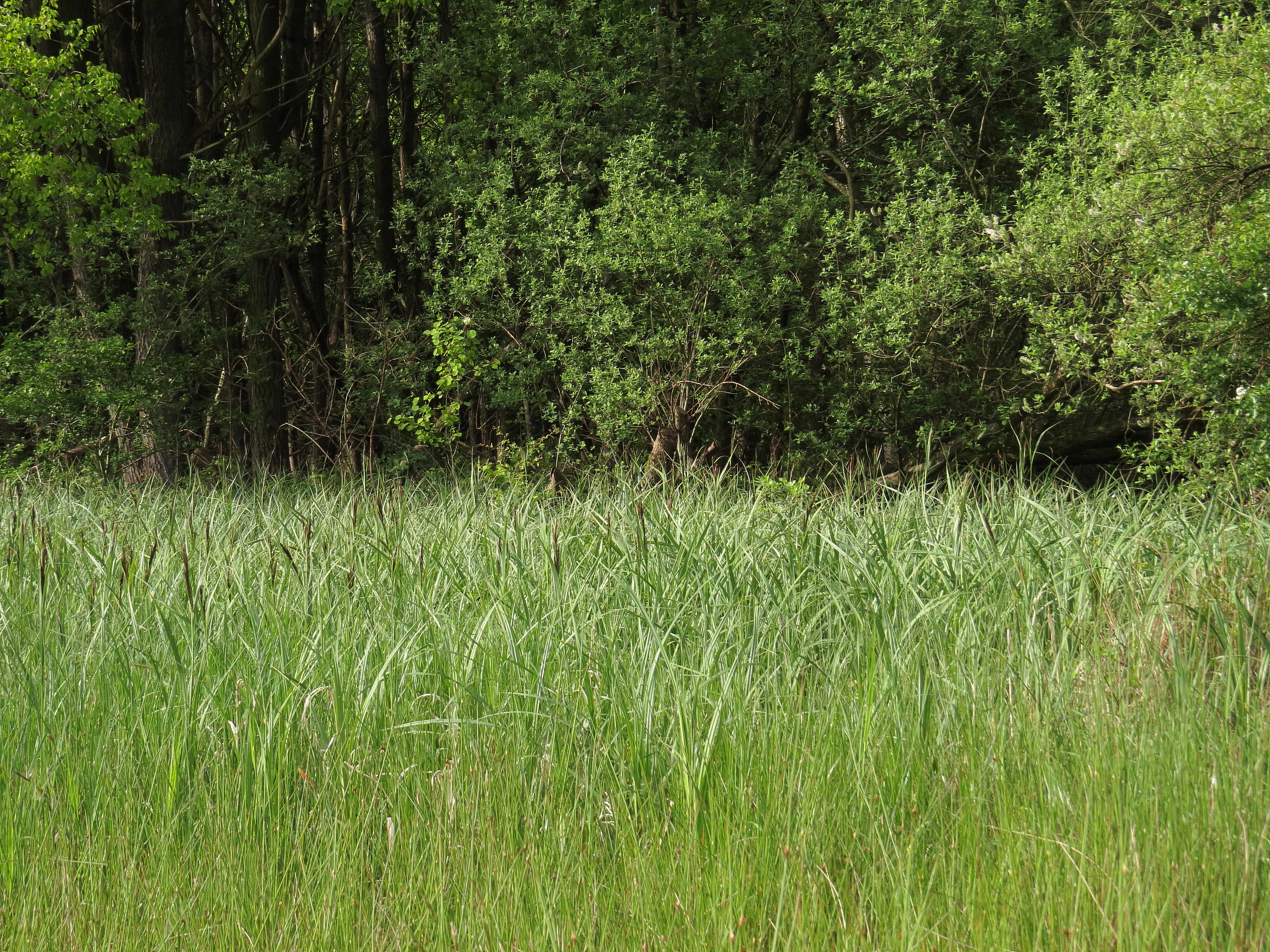
A wide, green sedge meadow in the foreground leading to a dense wall of trees and shrubs in the background.
A dense sedge meadow bordering a lush woodland in the Düllhamm nature reserve.

Düllhamm ecosystems, habitats, and plant life

Ecologically, Düllhamm is defined by the small-scale alternation of woodland, wet meadow, moor-like heath, reed beds, and swampy pockets. The oak-birch forest on the western side represents a typical northwest German lowland woodland community, with a well-developed herb and shrub layer beneath the canopy that supports shade-tolerant woodland flora and the invertebrates associated with it.

The wetter eastern half of the reserve belongs to an entirely different ecological system. Here, species-rich moist grassland dominated by blue moor-grass and purple moor-grass transitions into moor-like heath patches, while reed beds and tall-herb fringes add further structural and botanical diversity. Small swamps, reed stands, and willow thickets embedded within and along the forest edge act as transitional habitats that link the woodland and open-ground systems.

The interplay between these habitats is central to the nature of the reserve. Within just a few hectares, Düllhamm supports a hydrological gradient from relatively dry forest soils to permanently saturated boggy ground. This variety allows plants and animals adapted to very different conditions to coexist within the same protected site, making the reserve a disproportionately rich ecological asset in an otherwise heavily used coastal urban environment.
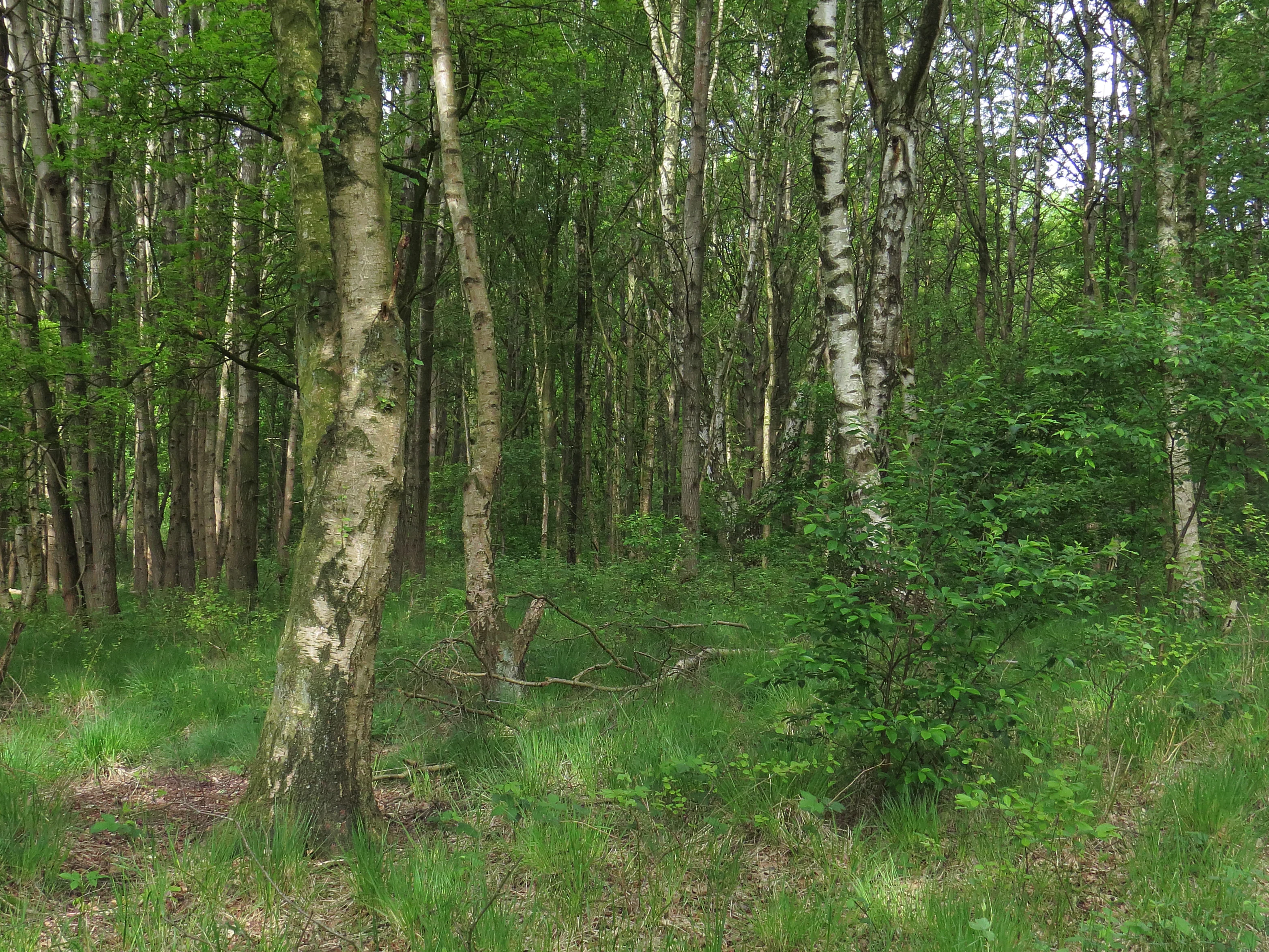
A dense patch of birch and oak trees in a forest setting with a grassy understory.
A characteristic birch and oak forest area within the Düllhamm nature reserve.

Düllhamm wildlife and species highlights

The wildlife value of Düllhamm is closely linked to its habitat diversity rather than to any single dominant species. The combination of oak-birch woodland, wet meadow, reed beds, and boggy heath provides a range of niches for woodland birds, wetland birds, amphibians, and invertebrates typical of northwest German lowland habitats.

The reed beds and wet grassland are particularly relevant for birds and insects associated with damp grassy environments, while the oak-birch woodland offers nesting and foraging habitat for typical lowland woodland bird species. The mosaic of dry and wet conditions also supports amphibians that depend on both terrestrial cover and standing or slow-moving water for parts of their life cycle. Invertebrate communities benefit from the structurally rich herb layer in the forest, the flowering plants of the tall-herb fringes, and the specialized flora of the boggy meadow.

While the reserve is too small to support populations of larger mammals, it functions as a refuge and stepping stone for smaller species within an intensively used urban and industrial landscape. Its protected status helps maintain habitat continuity within the surrounding Surheide-Süd/Ahnthammsmoor landscape protection area, supporting wildlife movement and ecological resilience at a regional scale.
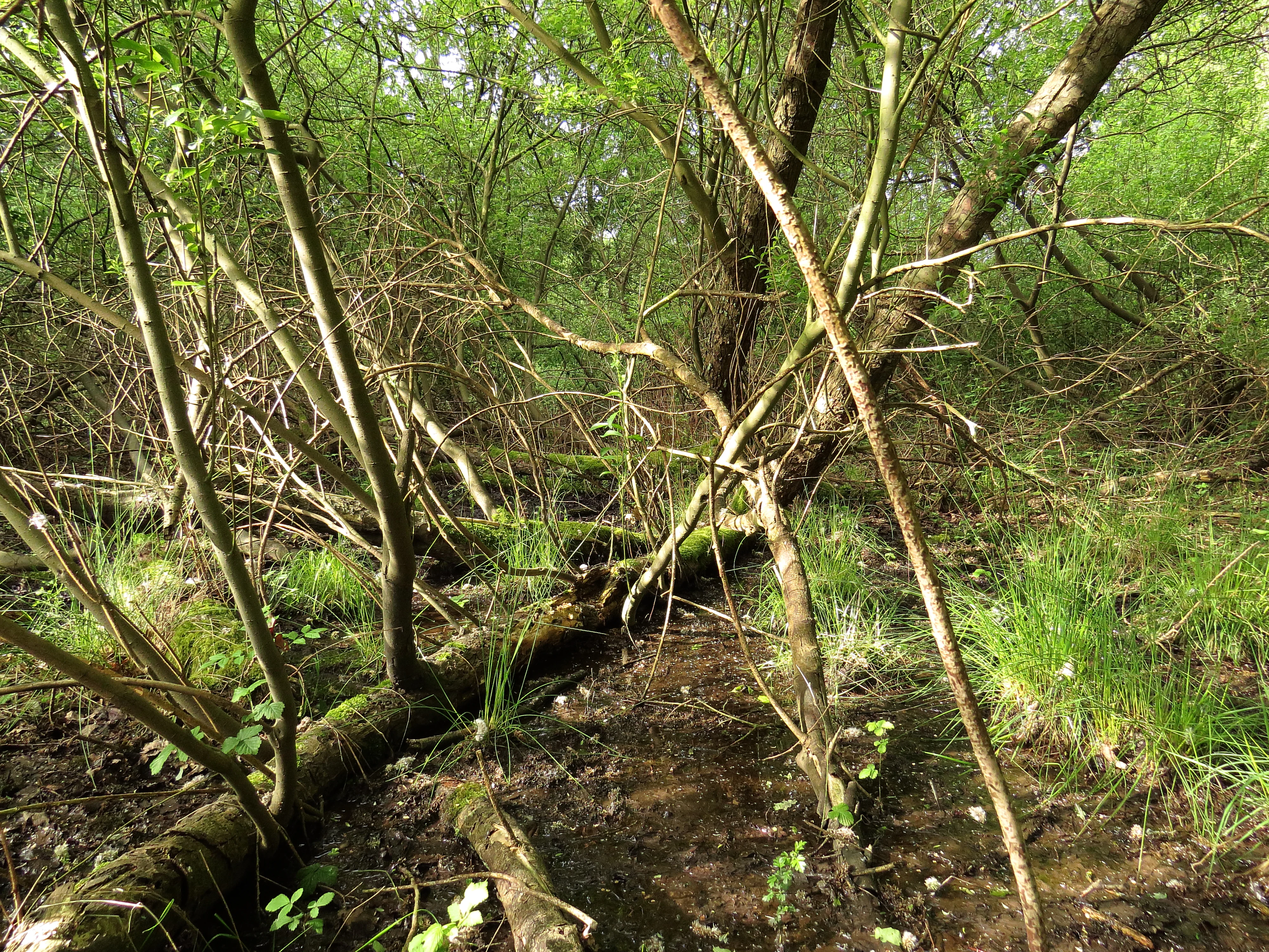
Dense forest undergrowth in the Düllhamm nature reserve with mossy fallen logs, patches of green grass, and wet muddy ground.
A dense, waterlogged section of the Düllhamm nature reserve showing damp soil and fallen timber.

Düllhamm conservation status and protection priorities

Düllhamm's conservation significance lies in safeguarding a small but ecologically diverse set of habitats that are otherwise vanishing from the Bremen region. As a formally designated Naturschutzgebiet, it enjoys the highest level of habitat protection available under German nature conservation law, with restrictions on land use, vegetation management, and disturbance aimed at maintaining the site's natural character.

The reserve plays an outsized role relative to its size by protecting a transition zone between dry forest and wet grassland, including boggy heath habitats with characteristic indicator grasses. These transitional habitats are particularly vulnerable to changes in land use, drainage, or nutrient input, and their preservation depends directly on the reserve's protected status. By maintaining both the forested and open wetland systems within a single small area, Düllhamm contributes to regional biodiversity conservation in a setting where large undisturbed landscapes are no longer available.

Its inclusion within the broader Surheide-Süd/Ahnthammsmoor landscape protection area extends its conservation value beyond the strict reserve boundary, embedding it within a larger matrix of protected countryside. This hierarchical approach, with strict core protection at Düllhamm and broader landscape protection around it, helps maintain ecological functions such as species movement and hydrological balance across the wider area.

Düllhamm cultural meaning and human context

Düllhamm reflects the broader regional history of land use in the marshes, heaths, and lowland forests around the lower Weser area. The mix of remaining woodland, wet grassland, and boggy heath is characteristic of traditional northwest German rural landscapes that were once common but have been increasingly altered by urban growth, drainage, and agriculture.

The reserve sits in the Surheide district of Bremerhaven, a part of the city where traces of older rural and natural landscapes have endured alongside expanding residential, industrial, and transport infrastructure. The contrast with the adjacent Bremerhaven–Buxtehude railway line and surrounding settlement areas highlights how the reserve preserves a piece of regional natural heritage within a heavily modified urban setting.

While there is no specific documented indigenous or folk-cultural association unique to Düllhamm, the broader landscape type it represents has long shaped local identity in the region. Preserved patches like Düllhamm serve as living references to the natural environment that once dominated the area around Bremerhaven before large-scale urbanization and harbor development transformed the coastal zone.

Top sights and standout views in Düllhamm

Düllhamm's standout qualities are its compact size combined with unusually high habitat diversity, including oak-birch woodland, wet grassland, boggy heath, reed beds, and small swampy pockets. It is one of only a handful of formally designated nature reserves within Bremerhaven and is tightly embedded in the larger Surheide-Süd/Ahnthammsmoor landscape protection area. The reserve provides an unexpectedly complete miniature of the wetland-influenced lowland ecosystems characteristic of the Bremen region.

A further highlight is the site's role as a protected refuge for transitional habitats that bridge dry woodland and permanently wet boggy ground, a pattern that has become rare in the surrounding urban and industrial landscape. The protected mosaic of grasses, reeds, and woodland understory creates habitat conditions that support a wide range of native flora and fauna within just a few hectares.

Best time to visit Düllhamm

As a small, low-lying nature reserve in the temperate coastal climate of northern Germany, Düllhamm is accessible for quiet exploration throughout much of the year, with conditions varying mainly with the seasons rather than with major weather extremes. Spring and early summer typically bring the most active growth in the reed beds and tall-herb fringes, when moor-grass meadows and woodland understory plants are most visibly in flower, and when wetland birds and amphibians are most active around the wetter eastern side of the reserve.

Late summer and early autumn offer a different character, with mature reed stands, golden grasses, and the moor-like heath patches taking on warmer tones, while the oak-birch woodland still provides shaded cover. Winter visits reveal the underlying landscape structure more clearly, when leaf-off trees expose the forest layout, and the contrast between dry woodland and boggy ground is easier to observe, although the wetter areas may be more difficult to walk through.

Overall, the reserve rewards visitors who are interested in subtle seasonal changes in a small but ecologically rich site, rather than dramatic seasonal phenomena. Its compact size and protected status mean that visits are typically short and observational rather than activity-oriented, and conditions vary more with weather and season than with any formal schedule.

Monthly climate preview

Long-term representative point measurements for Düllhamm weather by month

Düllhamm Climate Normals and Annual Temperature Rhythm

Representative coordinates record measured monthly temperature swings and precipitation levels across the Düllhamm landscape based on historical climatology data. Reviewing the complete twelve-month normals provides deeper analytical context on long-term thermal and moisture patterns.
Annual mean9 °C
1 °C18 °C
Jan
Feb
Mar
Apr
May12°
Jun16°
Jul18°
Aug18°
Sep14°
Oct10°
Nov
Dec
Warmest month
July

17.9 °C

Coolest month
January

1.2 °C

Wettest month
July

2.6 mm/day

Driest month
April

1.4 mm/day

Park location guide

Geography guide, regional context, and park location map for Düllhamm

Düllhamm park geography, regions, and map view in Germany

Understand where Düllhamm sits in Germany through a broader geographic reading of the surrounding landscape, nearby location context, and its mapped position within the national park landscape.

How Düllhamm fits into Germany

Germany is a federal republic in Western and Central Europe with a population of over 83 million across sixteen constituent states. It is Europe's largest economy by nominal GDP and a major global exporter and importer. The capital is Berlin, and the country borders Denmark, Poland, Czech Republic, Austria, Switzerland, France, Luxembourg, Belgium, and the Netherlands.

Wider geography shaping Düllhamm in Germany

Germany is located in Western and Central Europe, spanning 357,022 km². It borders Denmark to the north, Poland and the Czech Republic to the east, Austria and Switzerland to the south, and France, Luxembourg, Belgium, and the Netherlands to the west. The country has coastlines on the Baltic Sea and North Sea to the north, with the Alps located in the southern region.

Map view of Düllhamm

Use this park location map to pinpoint Düllhamm in Germany, understand its exact geographic position, and read its mapped placement within the surrounding landscape more clearly.

Pigeon | © OpenStreetMap contributors

Location context for Düllhamm

Bremen

Visual exploration of habitats, terrain, and regional woodland views

Düllhamm Photos, Scenery, and Protected Landscape Imagery

Visual documentation of Düllhamm reveals the intricate mosaic of dry oak woodland, wet grassland, and boggy heath within a compact protected area. Examining these protected terrain views and habitat transitions helps visitors understand the unique ecological character of the lowland reserve.

A wide, horizontal view of a lush green meadow surrounded by dense trees under a bright sky.

A small pool of water surrounded by deciduous trees and tall grass in a boggy forest setting.

A wide, green sedge meadow in the foreground leading to a dense wall of trees and shrubs in the background.

A dense patch of birch and oak trees in a forest setting with a grassy understory.

Dense forest undergrowth in the Düllhamm nature reserve with mossy fallen logs, patches of green grass, and wet muddy ground.

Park atlas

Discover adjacent lowland reserves and connected natural landscapes across the surrounding region

Explore Protected Areas and Parks Near Düllhamm for Regional Comparison

Browsing parks near Düllhamm reveals how small urban nature reserves connect to broader lowland protection networks. Comparing adjacent woodland and wetland habitats offers valuable perspective on regional conservation landscapes.
A soft, light-toned watercolor painting of a wetland landscape featuring green fields, a small path, a line of trees, and a distant low hill.
Nature reserveBremen
About 4.5 km away#1 closest

West

Luneplate Nature Reserve: A Detailed Geographic Atlas of Bremen's Coastal Wetland Landscapes

Protected estuarine habitats and tidal geography in the Weser river basin

Luneplate Nature Reserve offers a rich study of coastal wetland geography. Spanning the interface between the Weser river and the North Sea, the reserve features extensive mudflats, saltmarshes, and reedbeds. This protected landscape serves as an essential migratory hub, providing habitat for diverse waterbird populations within the maritime environment of Bremerhaven.

Area
14.38 km²
Established
2015
IUCN
IV
Watercolor painting showing coastal wetlands with mudflats, salt marshes, and distant hills under a soft light
National parkLower Saxony
About 6.1 km away#2 closest

West

Lower Saxon Wadden Sea National Park: Protected Coastal Landscape & Geography Atlas

Explore mapped boundaries, intertidal zones, and Lower Saxony's natural terrain.

Delve into the Lower Saxon Wadden Sea National Park, a significant national park situated in Lower Saxony, Germany. This page serves as your atlas entry point for understanding its protected landscape, characterized by vast mudflats, salt marshes, and a crucial role as a migratory bird corridor. Discover the geographic context of this UNESCO World Heritage site and its unique intertidal ecosystem through structured map data and detailed landscape information.

Area
345.8 km²
Established
1986
IUCN
II
Relief
Lowland
Nature reserveLandkreis Cuxhaven
About 13 km away#3 closest

South

Teichfledermausgewässer Nature Reserve: Mapped Geography of the Lower Weser Lowland Waters

Protected riverine habitats and lowland water mosaic in Germany

Teichfledermausgewässer functions as a vital nature reserve within the Landkreis Cuxhaven region. This protected landscape encompasses a rich mosaic of oxbow stretches, lowland rivers, and former clay extraction pits that support rare wildlife. Through its integrated water bodies, the reserve forms a continuous conservation corridor that preserves the ecological integrity of the Lower Weser estuary and its unique floodplain ecosystems.

Area
6.33 km²
Established
2018
Nature reserveLower Saxony
About 17 km away#4 closest

Southeast

Wollingster See und Randmoore: A Detailed Map and Geography of This Lower Saxony Nature Reserve

Examining the intersection of glacial lake basins and bog restoration efforts

Wollingster See und Randmoore protects a critical intersection of aquatic and terrestrial ecosystems within Lower Saxony. Learn about the reserve's formation as a potential pingo or glacial pothole, its distinct water quality, and the ongoing efforts to restore its surrounding raised-bog and moor-heath landscape through traditional grazing and rewetting.

Area
1.17 km²
Established
1932
IUCN
IV
Relief
Lowland
Nature reserveLower Saxony
About 17 km away#5 closest

Southwest

Strohauser Vorländer und Plate Nature Reserve: Geography and Protected Area Atlas

Tidal wetlands and freshwater habitats in Lower Saxony

The Strohauser Vorländer und Plate nature reserve protects a expansive tidal floodplain characterized by its river island geography, slow-moving side arms, and seasonal inundation patterns. As a focal point for meadow-bird monitoring, this site offers a clear view into the ecological dynamics of the Lower Weser river landscape, showcasing a rare combination of summer-dike-protected meadows and open freshwater tidal flats.

Area
11.52 km²
Established
2007
IUCN
IV
Nature reserveLower Saxony
About 19 km away#6 closest

East

Windbrackenholz Nature Reserve: A Detailed Look at Lower Saxony Woodland Geography

Protected oak-beech habitat in the Cuxhaven district.

Windbrackenholz represents a key example of long-standing forest conservation in the Lower Saxony lowlands. This nature reserve provides a critical window into the structure of Geest woodland habitats, characterized by its mature oak and beech trees and its integration into the wider regional forest mosaic. Delve into the protected boundaries and landscape context of this significant northwestern German site.

Area
0.34 km²
Established
1985
IUCN
IV
Nature reserveLower Saxony
About 20 km away#7 closest

South

Südliches Hagener Königsmoor Nature Reserve: A Protected Peatland in Lower Saxony

Ecological mosaic of bog woodland and historical peat cuttings

Südliches Hagener Königsmoor is a protected nature reserve in Hagen im Bremischen, Lower Saxony. The terrain features a distinct mosaic of raised bog vegetation, drainage channels, and water-filled peat cuttings that anchor a rare remnant of the original lowland moor landscape against modern agricultural surroundings.

Area
0.85 km²
Established
1981
IUCN
IV
Protected landscapeNiedersachsen
About 23 km away#8 closest

Southwest

Dornebbe, Braker Sieltief und Colmarer Tief: Mapped Protected Landscape in Niedersachsen

Geographic atlas of tidal lowland waterways and coastal habitats

Dornebbe, Braker Sieltief und Colmarer Tief comprises a chain of slow-flowing streams and bank habitats essential to the coastal marshland geography of Niedersachsen. The area provides a structured look at multi-layered habitat protection, featuring dense reedbeds and aquatic corridors vital for regional biodiversity in the German tidal zone.

Area
0.33 km²
Established
2018

Common questions about visiting, size, designation, and location context for Düllhamm

Düllhamm FAQs for park facts, access, geography, and protected area context

Find quick answers about Düllhamm, including protected-area facts, park geography, trail and visitor context, and how the park fits into its surrounding country and regional landscape.
MoriAtlas Explorer

Continue Your Protected Areas Search Across the Global Atlas

Deepen your exploration by continuing the structured search for national parks and protected areas worldwide. Utilize the comprehensive filtering capabilities to compare different conservation landscapes and refine your understanding of global park geography. Discover more about the distribution and characteristics of protected natural areas.

Global natural geography