

Mori Atlas logo
State or regional parkDune Za Keyih Provincial Park and Protected Area

Geographic landscape analysis of the Gataga River watershed and Rocky Mountain Trench corridor

Dune Za Keyih Provincial Park and Protected Area: Mapping the Intact Northern Wilderness

Dune Za Keyih Provincial Park and Protected Area represents a premier example of wilderness conservation in northern British Columbia, Canada. Centered on the expansive Gataga River watershed within the Rocky Mountain Trench, this protected land preserves an unlogged ecological complex of immense geographic importance. The terrain features a dramatic sequence of valley systems, mountain slopes, and ridgelines that remain largely undisturbed, offering a vital study in remote northern topography and watershed integrity.

wilderness areaRocky Mountain Trenchwatershed conservationintact forest landscapeMuskwa-Kechika Management AreaKaska Dena cultural landscape

Dune Za Keyih Provincial Park and Protected Area

State or regional park

Park overview

Structured park overview, official facts, and landscape profile for Dune Za Keyih Provincial Park and Protected Area

Dune Za Keyih Provincial Park and Protected Area park facts, protected area profile, and essential visitor context

Review the core facts for Dune Za Keyih Provincial Park and Protected Area, including designation, size, terrain, visitor scale, habitats, and operating context in one park-focused overview.

About Dune Za Keyih Provincial Park and Protected Area

Dune Za Keyih Provincial Park and Protected Area is a vast wilderness reserve in northeastern British Columbia, occupying a central position within the Rocky Mountain Trench. The park revolves around the Gataga River and the surrounding watershed, which remains entirely unlogged, making it the largest unlogged watershed of its kind in British Columbia. This unbroken condition of the land is the foundation of the park's identity as a nature reserve, distinguishing it from many other large protected areas that still bear a history of industrial land use.

The park sits within the broader Muskwa-Kechika Management Area, a regionally significant framework that balances conservation with multiple land uses across a huge swath of northern British Columbia. Within this network, Dune Za Keyih functions as a strictly protected core, buffered by neighboring parks: Denetiah Provincial Park lies to the west across the Kechika River, and Kwadacha Wilderness Provincial Park lies to the east. Together, these reserves form a continuous corridor of protected wilderness running through the northern Rockies.

Geographically, the park is shaped by the long, linear valley of the Rocky Mountain Trench, framed by mountain ranges on either side. Its isolation is extreme. There are no roads into the park, and the surrounding terrain is rugged and difficult to traverse. Humans remain a distant presence, and the plant and animal communities of the park are essentially free from the pollution, habitat fragmentation, and disturbance that affect more accessible landscapes. This combination of size, intactness, and remoteness is what makes Dune Za Keyih stand out as a Canadian protected area, offering a rare example of a large northern watershed left in a near-natural state.

The cultural dimension of the park is reflected in its name. Originally established as Frog-Gataga Provincial Park in 2001, it later took on the name Dune Za Keyih, a Kaska Dena translation of Frog-Gataga. This naming connects the park to the indigenous peoples of the region and signals a recognition of the longstanding relationship between Kaska Dena communities and this landscape.

Quick facts and research context for Dune Za Keyih Provincial Park and Protected Area

Dune Za Keyih Provincial Park and Protected Area lies in the Stikine Region of northeastern British Columbia and is centered in the Rocky Mountain Trench along the Gataga River. It was established in 2001 under the name Frog-Gataga, with the current Kaska Dena name adopted later. The park covers roughly 346,833 hectares and is classified by the IUCN as a Category Ib wilderness area, emphasizing its undeveloped, large-scale natural character.

It forms part of the Muskwa-Kechika Management Area and sits between Denetiah Provincial Park to the west and Kwadacha Wilderness Provincial Park to the east. The park contains the largest unlogged portion of any watershed in British Columbia and is governed by BC Parks. Its extreme remoteness means there is essentially no road access, and visitors typically reach the area by floatplane, helicopter, or occasionally jet boat.

Protection and recognition

Documented terrestrial protection scope and international recognition data

Dune Za Keyih Provincial Park and Protected Area Protection Status

Terrestrial protection status records detail the administrative framework established for Dune Za Keyih Provincial Park and Protected Area. Official recognition sources outline management scope and international designation parameters for this protected landscape.

Protection details

Protection scope
Terrestrial
Transboundary protection
No
Park context

Deeper park guide and search-rich context for Dune Za Keyih Provincial Park and Protected Area

Dune Za Keyih Provincial Park and Protected Area history, landscape, wildlife, and travel context

Explore Dune Za Keyih Provincial Park and Protected Area through its history, landscape character, ecosystems, wildlife, conservation priorities, cultural context, and seasonal travel timing in a structured park guide built for atlas discovery and search intent.

Why Dune Za Keyih Provincial Park and Protected Area stands out

Dune Za Keyih is best known for protecting the largest intact, unlogged watershed in British Columbia. This watershed-level integrity, rather than any single landmark or species, defines its ecological importance and gives the park a character of deep, continuous wilderness. The park is also recognized for its position within the Muskwa-Kechika Management Area, linking it to a broader network of protected lands in the northern Rockies. Combined with its classification as an IUCN Category Ib wilderness area, this places Dune Za Keyih among the most strictly protected undeveloped landscapes in the province.

Dune Za Keyih Provincial Park and Protected Area history and protected-area timeline

Dune Za Keyih Provincial Park and Protected Area was established on April 5, 2001, originally under the name Frog-Gataga Provincial Park. This establishment occurred as part of broader conservation initiatives in northeastern British Columbia aimed at protecting large, intact landscapes from industrial development, particularly logging and resource extraction. The park was created within the framework of the Muskwa-Kechika Management Area, a regional land-use arrangement designed to conserve wilderness values across a vast portion of northern British Columbia.

Following its establishment, the park's name was changed to Dune Za Keyih, drawn from the Kaska Dena language and serving as a translation of the original Frog-Gataga designation. The renaming reflects an effort to acknowledge the indigenous cultural heritage of the region and the historical presence of Kaska Dena peoples in the Gataga River area. Aside from this change in name, the park's protected status and wilderness character have remained consistent, and it continues to be managed by BC Parks as a Category Ib wilderness area under international IUCN guidelines.

Dune Za Keyih Provincial Park and Protected Area landscape and geographic character

The landscape of Dune Za Keyih is defined by the Rocky Mountain Trench, one of the most extensive and distinctive geological features of western North America. Within the park, the trench forms a long, broad valley through which the Gataga River flows, flanked by the rugged mountain ranges that give the northern Rockies their dramatic character. The terrain combines valley-bottom river systems with steep, rising mountainous country on either side.

The Gataga River and its tributaries shape the hydrology of the park, supporting an extensive, unfragmented watershed. The surrounding mountains create varied exposures and elevations, contributing to a mosaic of slopes, benches, drainage lines, and ridgelines across the protected area. Despite the relatively low level of human activity, the landscape retains its wild physical character, with vegetation, waterways, and landforms reflecting natural processes rather than management interventions.

Because the park has remained unlogged, the watershed retains a continuous cover of natural vegetation from valley bottom to higher slopes. Aerial views of the park reveal long ribbons of forest along the river corridors framed by uninhabited, lightly vegetated mountain terrain. The overall impression is of a vast, remote northern landscape where physical geography has been left largely undisturbed.

Dune Za Keyih Provincial Park and Protected Area ecosystems, habitats, and plant life

The ecological character of Dune Za Keyih is shaped primarily by the intactness of its Gataga River watershed. Because the watershed has never been logged, the plant communities associated with it have developed without the fragmentation or compositional changes that typically follow forestry activity. This continuity supports stable habitat conditions, including intact riparian vegetation along rivers and streams, and unbroken forest cover extending across the broader valley landscape.

The park's ecological condition is further reinforced by the absence of significant pollution sources. Because the area lies far from settlements, roads, and industrial sites, the air, water, and soils remain relatively undisturbed. Together, these factors create the conditions for a functioning northern Rocky Mountain ecosystem in which vegetation patterns and ecological processes remain closely tied to natural cycles of disturbance and recovery.

The combination of watershed-scale habitat integrity, large area, and remoteness gives Dune Za Keyih a more ecologically complete character than many comparable protected landscapes in British Columbia. The park does not protect just a set of species or habitats in isolation, but rather an entire watershed system functioning as a whole.

Dune Za Keyih Provincial Park and Protected Area wildlife and species highlights

Wildlife in Dune Za Keyih benefits from the same conditions that define the park at large: an intact watershed, a large protected area, and minimal human disturbance. Because the park is far from the impacts of human activity, animals here are able to live and hunt across the landscape without the fragmentation, noise, or direct conflict that often accompany development in similar northern environments.

The unbroken nature of the vegetation and the clean condition of the rivers and streams support a complete wildlife community, with predators and prey, aquatic species, and terrestrial mammals all able to use the landscape in relatively natural ways. The park's role within the larger Muskwa-Kechika Management Area also reinforces its wildlife value, as animals are not confined to the park boundary but can move across a much wider network of low-impact terrain.

This means that Dune Za Keyih functions less as a site of rare or unusual species and more as a refuge for the full set of wildlife expected in a northern Rockies watershed, maintained in a state close to its pre-industrial condition.

Dune Za Keyih Provincial Park and Protected Area conservation status and protection priorities

The conservation significance of Dune Za Keyih rests on a simple but powerful premise: a large watershed left untouched by logging in a province where industrial forestry has shaped most other landscapes. As the largest unlogged watershed in British Columbia, the park represents a reference point for what undisturbed northern watershed conditions look like.

Within the Muskwa-Kechika Management Area, Dune Za Keyih serves as one of the strictly protected cores, anchored on either side by Denetiah Provincial Park and Kwadacha Wilderness Provincial Park. This spatial arrangement creates a substantial protected corridor through the northern Rockies, where conservation values rather than resource extraction define land use. The IUCN Category Ib wilderness designation assigned to the park formalizes this purpose, emphasizing the protection of large-scale, unmodified natural environments.

By maintaining an entire watershed in an intact state, the park contributes to long-term regional conservation goals: preserving habitat connectivity, safeguarding clean water systems, protecting biodiversity at the landscape scale, and providing a benchmark for ecological monitoring in the surrounding region.

Dune Za Keyih Provincial Park and Protected Area cultural meaning and human context

The cultural context of Dune Za Keyih is closely tied to the Kaska Dena people, the indigenous inhabitants of the region in which the park lies. The original name of the park, Frog-Gataga, was translated into the Kaska Dena language as Dune Za Keyih, embedding the indigenous heritage of the area directly into the park's identity.

This renamed reflects a broader recognition of the longstanding relationship between Kaska Dena communities and the Gataga River watershed and surrounding mountains. Although the park is remote and largely undeveloped, the act of renaming ensures that the cultural landscape of the region is acknowledged alongside its ecological value. The park thus stands as both a natural and a cultural inheritance, shaped by the histories and languages of the people who have lived with this land for generations.

Top sights and standout views in Dune Za Keyih Provincial Park and Protected Area

The defining highlight of Dune Za Keyih is its status as the largest unlogged watershed in British Columbia, supported by a deeply remote setting in the Rocky Mountain Trench. Combined with its IUCN wilderness classification and its position between neighboring protected areas, the park offers an exceptionally complete example of an undisturbed northern watershed.

Its location within the Muskwa-Kechika Management Area and its Kaska Dena name add further layers to its significance, linking ecological integrity with regional land-use planning and indigenous cultural recognition. Together, these qualities make Dune Za Keyih a standout wilderness reserve in Canada's protected-area system.

Best time to visit Dune Za Keyih Provincial Park and Protected Area

Given the extreme remoteness of Dune Za Keyih and its lack of road access, the timing of any visit is shaped primarily by weather, daylight, and the operational windows for floatplane, helicopter, or jet-boat access into the northern Rockies. Summer and early autumn generally offer the most stable conditions for accessing remote valleys and rivers, with longer daylight hours supporting extended travel on the land. Winter brings deep snow, extreme cold, and very limited access.

Because the park is essentially undeveloped for tourism, there are no seasonal visitor services in the way one would find at more accessible parks. Any visit effectively functions as a wilderness expedition, and timing decisions should focus on safe weather windows and the seasonal behavior of the wildlife and landscapes one hopes to experience.
Monthly climate preview

Long term temperature and precipitation patterns across representative elevations

Dune Za Keyih Provincial Park and Protected Area Climate Normals

Representative coordinates record severe sub-zero winter lows alongside moderate summer warmth and distinct monthly precipitation shifts. Detailed monthly data profiles reveal the complete long-term climate trajectory captured at high elevation.
Annual mean-5 °C
-17 °C9 °C
Jan-17°
Feb-15°
Mar-12°
Apr-6°
May
Jun
Jul
Aug
Sep
Oct-5°
Nov-14°
Dec-16°
Warmest month
July

9.3 °C

Coolest month
January

-16.8 °C

Wettest month
June

3.9 mm/day

Driest month
February

1.3 mm/day

Park location guide

Geography guide, regional context, and park location map for Dune Za Keyih Provincial Park and Protected Area

Dune Za Keyih Provincial Park and Protected Area park geography, regions, and map view in Canada

Understand where Dune Za Keyih Provincial Park and Protected Area sits in Canada through a broader geographic reading of the surrounding landscape, nearby location context, and its mapped position within the national park landscape.

How Dune Za Keyih Provincial Park and Protected Area fits into Canada

Canada is a federal parliamentary constitutional monarchy spanning North America from the Atlantic to the Pacific and Arctic Oceans. With a population of over 41 million, it is officially bilingual in English and French at the federal level. The country gained independence from the United Kingdom through a gradual process culminating in 1982.

Wider geography shaping Dune Za Keyih Provincial Park and Protected Area in Canada

Canada occupies the northern portion of North America, sharing its longest international border with the United States. The country extends from the Atlantic Ocean to the Pacific Ocean and northward into the Arctic Ocean, giving it the longest coastline of any nation.

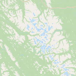
Map view of Dune Za Keyih Provincial Park and Protected Area

Use this park location map to pinpoint Dune Za Keyih Provincial Park and Protected Area in Canada, understand its exact geographic position, and read its mapped placement within the surrounding landscape more clearly.

Pigeon | © OpenStreetMap contributors

Location context for Dune Za Keyih Provincial Park and Protected Area

British ColumbiaStikine Region
Park atlas

Discover connected protected landscapes across the northern Rockies and Rocky Mountain Trench.

Parks Near Dune Za Keyih Provincial Park and Protected Area for Regional Wilderness Comparison

Browse adjacent protected areas and neighboring provincial parks that share the rugged terrain of northern British Columbia. Comparing these remote wilderness zones reveals the broader scale of regional watershed conservation and intact mountain ecosystems.
State or regional parkBritish Columbia
About 45 km away#1 closest

West

Denetiah Provincial Park and Protected Area: Regional Geography and Wilderness Mapping

An undisturbed boreal reserve in the Stikine Region

Discover the geographic structure of Denetiah Provincial Park and Protected Area, a vast roadless landscape in northern British Columbia. This park protects pristine boreal forests, elongated glacial lake basins, and critical river headwaters that serve as a benchmark for northern conservation within the Muskwa-Kechika Management Area.

Area
1,053.49 km²
Established
1999
IUCN
II
Relief
Upland
State or regional parkBritish Columbia
About 77 km away#2 closest

Southeast

Kwadacha Wilderness Provincial Park: Geographic Boundaries and Regional Protected Area Context

Untouched mountain wilderness in northern British Columbia

Kwadacha Wilderness Provincial Park provides a rare, roadless mountain experience within the northeastern interior of British Columbia. Characterized by high-relief alpine ridges, dense boreal forests, and challenging river systems, the park represents an essential wilderness corridor that remains free from human infrastructure and standard road access, prioritizing ecological integrity over recreation.

Area
1,302.79 km²
Established
1973
IUCN
Ib
Relief
Mountain
State or regional parkBritish Columbia
About 88 km away#3 closest

Northwest

Horneline Creek Provincial Park: Protected Canyon Landscapes and Rocky Mountain Trench Geography

Remote glacial-terrace wilderness in northern British Columbia

Located deep in the Rocky Mountain Trench, Horneline Creek Provincial Park is defined by its deep-cut canyon and ancient glacial terraces. This protected area offers an intimate view of sub-boreal terrain where mineral-stained walls and aspen-dotted grasslands create a concentrated, ecologically significant landscape within a remote corner of northern British Columbia.

Area
2.98 km²
Established
1999
IUCN
II
Relief
Upland
State or regional parkBritish Columbia
About 95 km away#4 closest

South

Finlay-Russel Provincial Park and Protected Area: Mapping Northern British Columbia Wilderness

A remote river corridor in the Muskwa-Kechika Management Area.

Located in northern British Columbia, Finlay-Russel Provincial Park and Protected Area preserves an essential 85-kilometre river corridor along the Finlay River. This expansive wilderness territory serves as an integral part of the Muskwa-Kechika Management Area, showcasing deep boreal forest landscapes and rugged river valley terrain far from established road networks.

Area
1,092.05 km²
Established
2001
IUCN
II
Access
Remote access
A pale, minimalist watercolor painting of a river landscape with distant rolling hills, marshy grasses, and light tree clusters under a bright sky.
State or regional parkBritish Columbia
About 115 km away#5 closest

North

Liard River Hot Springs Provincial Park: Boreal Geothermal Mapping and Regional Geography

Protected northern wilderness, thermal water systems, and muskeg wetland terrain

Liard River Hot Springs Provincial Park serves as a protected geographic nexus where thermal water discharge creates a unique biological oasis. The park landscape combines expansive boreal forest with sensitive muskeg wetlands, centered around a natural hot spring system that supports orchid populations and regular wildlife sightings. This atlas entry provides essential context on the physical boundaries and ecological features that define this significant regional park in northern British Columbia.

Area
10.82 km²
Established
1957
IUCN
III
Relief
Lowland
State or regional parkBritish Columbia
About 157 km away#6 closest

Southeast

Redfern-Keily Provincial Park: A Deep Dive into Muskwa Ranges Protected Geography

Remote Glacial Landscapes and Northern Wilderness Terrain

Redfern-Keily Provincial Park encompasses a significant stretch of remote wilderness in the Muskwa Ranges of northeastern British Columbia. Anchored by the eight-kilometer Redfern Lake and surrounding glaciers like the Ithaca and Achaean, the area serves as a primary example of intact boreal and subalpine geography. The terrain offers a rugged look at high-elevation ecosystems and glacial history within the Muskwa-Kechika Management Area.

Area
807.12 km²
Established
1999
IUCN
II
Relief
Mountain
State or regional parkBritish Columbia
About 158 km away#7 closest

Southeast

Prophet River Hot Springs Provincial Park: Protected Landscape and Geothermal Geography

Remote backcountry wilderness in northeastern British Columbia

Prophet River Hot Springs Provincial Park is a specialized protected area known for its unique tufa mounds and geothermal features. Set against the mountainous backdrop of the Muskwa Ranges, this backcountry destination offers a compelling study of boreal and subalpine geography, accessible only by hiking or horseback through undisturbed wilderness corridors.

Area
1.84 km²
Established
1999
IUCN
II
Relief
Mountain
Nature reserveBritish Columbia
About 176 km away#8 closest

Southwest

Gladys Lake Ecological Reserve: Remote Wilderness and Alpine Geography in British Columbia

Scientific reference area on the Spatsizi Plateau

Explore the expansive geography of Gladys Lake Ecological Reserve, a major protected area located in the remote interior of British Columbia. This reserve provides a strictly preserved natural landscape defined by high-elevation ridges, subalpine transitions, and the pristine wilderness of the Eaglenest Range, serving as a benchmark for ecological research in Canada.

Area
440.98 km²
Established
1975
IUCN
Ia
Relief
Mountain

Common questions about visiting, size, designation, and location context for Dune Za Keyih Provincial Park and Protected Area

Dune Za Keyih Provincial Park and Protected Area FAQs for park facts, access, geography, and protected area context

Find quick answers about Dune Za Keyih Provincial Park and Protected Area, including protected-area facts, park geography, trail and visitor context, and how the park fits into its surrounding country and regional landscape.
MoriAtlas Explorer

Continue Your Protected Areas Search Across the Global Atlas

Deepen your exploration by continuing the structured search for national parks and protected areas worldwide. Utilize the comprehensive filtering capabilities to compare different conservation landscapes and refine your understanding of global park geography. Discover more about the distribution and characteristics of protected natural areas.

Global natural geography