Mori Atlas logo
Nature reserveDunger See

A structured atlas overview of the post-industrial wetland habitat and regional bird protection network.

Dunger See Nature Reserve: Exploring the Wetland Landscapes and Protected Boundaries in Bremen, Germany

(Naturschutzgebiet Dunger See)

Dunger See represents a significant nature reserve located within the Werderland district of Bremen, Germany. This former gravel pit has been transformed into a dense, ecologically structured wetland featuring islands, shallow water zones, and reedy margins that serve as a crucial site for migrating waterfowl and breeding bird species. The reserve functions as an essential component of the regional bird protection network within the North German lowlands.

wetlandlake reserveurban nature reservebird sanctuarywaterbird habitatformer gravel pit

Dunger See

Nature reserve

Park overview

Structured park overview, official facts, and landscape profile for Dunger See Nature Reserve

Dunger See Nature Reserve park facts, protected area profile, and essential visitor context

Review the core facts for Dunger See Nature Reserve, including designation, size, terrain, visitor scale, habitats, and operating context in one park-focused overview.

About Dunger See Nature Reserve

Dunger See lies in the northwestern part of Bremen, in the Burglesum district, on the edge of the Werderland, a historically agricultural lowland between the Weser and Lesum rivers. Although Bremen is a compact city-state, the Werderland retains a distinctly rural character of meadows, ditches (Fleete), small woodlands, and dispersed farmsteads, and within that setting Dunger See functions as both a landscape feature and a key ecological node.

The lake itself is of relatively recent origin. Between 1977 and 1979, sand was excavated on the site for a planned cemetery along the Lesum; the cemetery was never completed, and the excavated pit filled with groundwater to become the present lake, which now sits adjacent to a golf course that occupies the unbuilt cemetery grounds. Importantly, the lake was not an accidental byproduct but a planned conservation feature: its design incorporated islands, shallow littoral zones, and a richly indented shoreline to maximize habitat value.

A roughly 33-hectare reserve surrounds the lake, registered as Bremen nature reserve No. 10 and protected since 1990. It is fully embedded in the larger Werderland Special Protection Area under the European Union Birds Directive, and neighbors the Werderland nature reserve to the southwest and the Lesum lowland landscape protection area to the east. This layered protection, from municipal to European, reflects the lake's recognized value for waterbird populations in the North German Plain.

The reserve is enclosed by a wooded screen, intentionally planted to reduce disturbance from surrounding farmland and paths, lending the lake a sense of seclusion unusual for a site within a major German city. Reeds and disturbed wetland vegetation border the eastern shore, while ditches, a field track, and a Fleet bound the reserve on its other sides.

Quick facts and research context for Dunger See Nature Reserve

Dunger See is a groundwater-fed lake of approximately 16.7 hectares in surface area, reaching a maximum depth of 12 meters. It sits within the Werderland, a low-lying rural district of northwest Bremen bordering the Lesum River.

The lake and adjoining land have been protected as a Naturschutzgebiet (nature reserve) since 18 July 1990 and are entirely encompassed by the EU Birds Directive Special Protection Area known as Werderland. Although the lake originated from industrial sand extraction, it was conceived as a conservation site from the outset and now functions primarily as a refuge for breeding, resting, and wintering waterbirds.

Protection and recognition

Analysis of terrestrial protected area boundaries and recognition records

Dunger See Protection Status and Documented Conservation Scope

Dunger See maintains a documented terrestrial protection scope defining its conservation boundaries. Records outline the established administrative framework and official recognition status governing the landscape.

Protection details

Protection scope
Terrestrial
Transboundary protection
No
Park context

Deeper park guide and search-rich context for Dunger See Nature Reserve

Dunger See Nature Reserve history, landscape, wildlife, and travel context

Explore Dunger See Nature Reserve through its history, landscape character, ecosystems, wildlife, conservation priorities, cultural context, and seasonal travel timing in a structured park guide built for atlas discovery and search intent.

Why Dunger See Nature Reserve stands out

Dunger See is best known as a successful example of a post-industrial waterbody turned into a functioning nature reserve. Its combination of artificial island groups, shallow zones, reedy margins, and surrounding afforestation creates a richly structured wetland habitat inside an urban federal state. The lake is particularly recognized for its ornithological importance: it hosts breeding great crested grebes, mute swans, and kingfishers, while cormorants and great egrets use the northern shore trees as a communal roost. In winter, the open water and sheltered bays attract large numbers of ducks and geese, cementing the lake's role within Bremen's wider bird protection network.
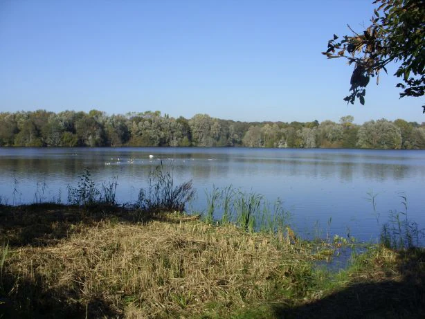
A wide view across the calm waters of Dunger See, with a dense forested shoreline in the distance and tall grasses in the foreground.
A view of the Dunger See nature reserve from the south shore observation area.

Dunger See Nature Reserve history and protected-area timeline

The history of Dunger See is unusually short and unusually pointed: it is the history of a landscape deliberately engineered for nature conservation out of an industrial scar.

The lake was created between 1977 and 1979 through sand extraction on behalf of a planned cemetery, the 'Friedhof an der Lesum', which was never completed. Today the area intended for the cemetery hosts a golf course, while the resulting pit became a lake. From its conception, the extraction plan incorporated measures to make the future waterbody ecologically valuable, including the preservation of islands and the shaping of shallow, structured margins.

On 18 July 1990, the lake and surrounding land were formally designated as a Naturschutzgebiet, listed as protection area No. 10 in Bremen's nature register. The designation was followed by integration into the EU Birds Directive Special Protection Area 'Werderland', formally recognizing the lake's importance for breeding and migratory bird populations and tying its management to broader European conservation objectives.

Dunger See Nature Reserve landscape and geographic character

Although compact, Dunger See displays a strikingly varied lakescape for its size. The shoreline is heavily indented with bays and inlets, and several small islands break the water surface, all features deliberately shaped during the original sand extraction. Shallow margins grade outward into reedbeds and wet scrub, especially along the eastern flank, where a Feuchtbrache, a damp fallow area, abuts the water.

The reserve is encircled by a dense ring of trees and shrubs, planted as a visual screen to suppress disturbance from surrounding farmland and paths. A drainage ditch bounds the area to the north and west, a Fleet (a typical Bremen lowland drainage canal) to the east, and a field track to the south. Two observation points, north and south of the lake, allow views across the water, with the southern stand offering the broader panorama.

The broader setting is the flat, polder-like Werderland, a traditional agricultural landscape whose straight ditches, damp meadows, and isolated farm buildings contrast with the more intimate, structurally diverse character of the lake reserve itself.

Dunger See Nature Reserve ecosystems, habitats, and plant life

The lake and its immediate surroundings form a richly structured wetland complex within an otherwise intensively used lowland agricultural matrix. The combination of open water, islands, shallow margins, reed fringes, and damp fallow gives the reserve a layered ecological profile unusual in such a small area.

Wetland vegetation dominates the margins, particularly along the eastern shore, where reeds and damp unused land transition gradually into the water. The planted woodland screen encircling the reserve adds a terrestrial element, providing nesting cover, perching sites, and roosting structures, while also buffering the wetland core from external disturbance.

Nutrient levels in the lake are eutrophic, a condition typical of lowland waters in this region and one that, combined with the shallow zones, supports the high productivity of invertebrates and aquatic plants on which the lake's birdlife depends. The hydrological regime is characterized by groundwater input rather than surface inflows, contributing to relatively stable water levels.

Dunger See Nature Reserve wildlife and species highlights

Dunger See's wildlife value is overwhelmingly ornithological. The lake is a breeding habitat for several waterfowl species, and the surrounding reedbeds, wooded margins, and island shelters support a varied bird community throughout the year.

Among characteristic breeding species are great crested grebes (Haubentaucher) and mute swans, while ducks of various species are regular residents. The kingfisher (Eisvogel), a species of high conservation interest in Germany, is resident along the lake margins. Cormorants and great egrets (Silberreiher) use the tall trees along the northern shore as a communal night roost, adding a notable seasonal dimension to the lake's birdlife.

In the colder months, Dunger See becomes a stopover and wintering area for large numbers of ducks and geese, taking advantage of the open water and sheltered bays. This seasonal congregation is the principal reason for the lake's inclusion in the wider Werderland Special Protection Area under the EU Birds Directive.

Dunger See Nature Reserve conservation status and protection priorities

Dunger See's conservation significance operates at multiple administrative layers. At the municipal level, it is registered as Naturschutzgebiet No. 10 in the Bremen nature register; at the European level, it is fully encompassed by the Special Protection Area 'Werderland' under the EU Birds Directive, joining a network of sites aimed at protecting migratory and breeding bird populations.

The reserve's design embodies a deliberate conservation philosophy. Existing as a former extraction site, it has been actively reshaped to deliver ecological functions: islands and shallow zones for nesting and feeding waterbirds, wooded buffers to reduce human disturbance, and a peripheral network of ditches and Fleete that connect the lake hydrologically and ecologically to the surrounding Werderland.

Adjacent protected areas, including the Werderland nature reserve and the Lesumniederung landscape protection area, extend the conservation context beyond the lake's borders. Together, Dunger See and its neighbors form a contiguous lowland wetland mosaic of considerable importance for waterbird conservation in the Bremen region and the broader North German Plain.

Dunger See Nature Reserve cultural meaning and human context

The name Dunger See preserves the memory of two historical estates, the Große Dunge and Kleine Dunge, that stood east and southeast of the present lake. Their survival in the lake's name gives the otherwise modern reserve a thin but tangible layer of older rural heritage, situating the site within a long continuum of lowland agricultural land use.

The Werderland itself has a strong regional identity as a traditional farming and meadow landscape, defined by its network of drainage ditches and Fleete and by its dispersed farmsteads. Within Bremen's collective imagination, the Werderland functions as a kind of rural counterweight to the dense urban core of the city-state, and Dunger See, embedded in that landscape, contributes to that sense of accessible countryside within city limits.

Top sights and standout views in Dunger See Nature Reserve

Dunger See stands out as a compact but ecologically dense wetland: a former gravel pit reclaimed for nature, deliberately shaped with islands and shallow bays and buffered by planted woodland.

Its integration into the EU Werderland Special Protection Area ties the small Bremen lake into a continental bird conservation network, giving it significance far beyond its modest size. For visitors, the southern observation point offers an accessible viewpoint over most of the lake, while the north observation stand and connecting field paths allow quieter approaches. The combination of accessible infrastructure and undisturbed habitat pools makes Dunger See a notable example of urban-adjacent bird protection in northwestern Germany.

Best time to visit Dunger See Nature Reserve

Dunger See's character shifts distinctly between seasons. Spring and summer are the best periods to experience the lake as a breeding bird site, with great crested grebes, swans, ducks, and kingfishers active around the islands and reeded margins, and the wooded surroundings in fresh leaf.

Late autumn and winter transform the lake into a refuge and gathering point for migratory and wintering waterfowl, including large flocks of ducks and geese, with cormorants and great egrets using the northern tree line as a roost. The bare vegetation in colder months also makes waterbirds easier to observe from the southern and northern viewpoints. For those interested in waterbird wintering dynamics, the cold half-year offers the strongest ornithological experience; for habitat and breeding atmosphere, the warmer months are preferable.


Monthly climate preview

Long-term temperature ranges and precipitation trends across representative coordinates

Dunger See Climate Normals and Average Temperature Patterns

Dunger See exhibits measured annual temperature variations alongside steady monthly precipitation patterns based on historical data. Detailed weather by month breakdowns and complete climate normals provide deeper insight into long-term environmental conditions.
Annual mean9 °C
1 °C18 °C
Jan
Feb
Mar
Apr
May13°
Jun16°
Jul18°
Aug18°
Sep14°
Oct10°
Nov
Dec
Warmest month
July

18 °C

Coolest month
January

1 °C

Wettest month
July

2.5 mm/day

Driest month
April

1.4 mm/day

Park location guide

Geography guide, regional context, and park location map for Dunger See Nature Reserve

Dunger See Nature Reserve park geography, regions, and map view in Germany

Understand where Dunger See Nature Reserve sits in Germany through a broader geographic reading of the surrounding landscape, nearby location context, and its mapped position within the national park landscape.

How Dunger See Nature Reserve fits into Germany

Germany is a federal republic in Western and Central Europe with a population of over 83 million across sixteen constituent states. It is Europe's largest economy by nominal GDP and a major global exporter and importer. The capital is Berlin, and the country borders Denmark, Poland, Czech Republic, Austria, Switzerland, France, Luxembourg, Belgium, and the Netherlands.

Wider geography shaping Dunger See Nature Reserve in Germany

Germany is located in Western and Central Europe, spanning 357,022 km². It borders Denmark to the north, Poland and the Czech Republic to the east, Austria and Switzerland to the south, and France, Luxembourg, Belgium, and the Netherlands to the west. The country has coastlines on the Baltic Sea and North Sea to the north, with the Alps located in the southern region.

Map view of Dunger See Nature Reserve

Use this park location map to pinpoint Dunger See Nature Reserve in Germany, understand its exact geographic position, and read its mapped placement within the surrounding landscape more clearly.

Pigeon | © OpenStreetMap contributors

Location context for Dunger See Nature Reserve

Bremen

Explore the lakescape, artificial islands, and bird habitats defining this Bremen sanctuary.

Dunger See Photos and Landscape Scenery: Visualizing the Protected Wetland Reserve

Visual documentation captures the indented shorelines, reedy margins, and wooded buffer zones characterizing the protected wetland environment of Dunger See. Examining field photography reveals how a post-industrial gravel pit functions as a vital urban-adjacent sanctuary for migratory waterfowl and resident bird species.

A wide view across the calm waters of Dunger See, with a dense forested shoreline in the distance and tall grasses in the foreground.

Park atlas

Compare nearby lowland reserves and connected wetland habitats

Other Parks Near Dunger See and Protected Areas Across the Surrounding Region

Visitors exploring Dunger See can examine other protected areas and wetland reserves located throughout the surrounding North German lowlands. Comparing adjacent habitat networks provides broader geographic context for regional bird protection and lowland landscape conservation.
Nature reserveBremen
About 2.9 km away#1 closest

Northeast

Ruschdahlmoor Nature Reserve: Deep Peatlands and Protected Wetland Geography in Bremen

Geological subsidence sinkhole and urban protected landscape

Ruschdahlmoor stands as a unique nature reserve in Bremen, Germany, distinguished by a peat-forming wetland developed inside a sinkhole over the Lesum salt dome. This protected area supports tall herb meadows, reed-fringed ponds, and rare peat-depth records, offering a dense, ecologically rich landscape context that remains a vital part of the city's natural geography.

Area
0.048 km²
Established
1991
IUCN
IV
Relief
Lowland
A horizontal watercolor painting showing a tranquil lake scene with green trees, low-lying hills in the distance, and grassy banks against a white background.
Nature reserveBremen
About 3.2 km away#2 closest

East

Grambker Feldmarksee Nature Reserve: Mapping the Protected Landscapes of Bremen

A vital wetland sanctuary shaped by regional infrastructure and natural restoration

Grambker Feldmarksee offers a focused look at how post-industrial quarry sites evolve into ecologically dense nature reserves. This groundwater-fed lake in Bremen acts as a green island, showcasing mature woodland fringes and specialized wetland habitats that are integral to the local bird protection network.

Area
0.226 km²
Established
2009
Relief
Lowland
Climate
Temperate
Nature reserveBremen
About 4.4 km away#3 closest

East

Untere Wümme Nature Reserve: Riverine Biodiversity and Protected Tidal Landscapes in Bremen

Protected floodplain geography and tidal river habitats.

This nature reserve protects the meandering lower course of the Wümme river, showcasing one of northern Germany's few freshwater tidal systems. Spanning reedbeds, willow forests, and open mudflats, the reserve forms a vital corridor for migratory fish and waterfowl, reflecting a complex mosaic of protected riverine ecosystems and historic meadow landscapes.

Area
1.485 km²
Established
1991
Relief
Lowland
Climate
Temperate
Nature reserveBremen
About 5.3 km away#4 closest

Northwest

Hammersbecker Wiesen: Protected Nature Reserve and Meadow Landscape in Bremen

Ecological mosaic of wet meadows and stream valley terrain

Hammersbecker Wiesen encompasses 25.8 hectares of ecologically significant wet grassland and hedgerow habitats in Bremen. This nature reserve provides an essential refuge for diverse plant species and local amphibians within an urban-adjacent setting, illustrating the preserved character of traditional northern German meadow systems.

Area
0.258 km²
Established
1986
A watercolor painting showing a soft, panoramic view of a flat wetland area with green trees, a solitary tree in the middle, and industrial silos faintly visible in the background.
Nature reserveBremen
About 7.7 km away#5 closest

Southeast

Hochwasserschutzpolder zwischen Senator-Apelt-Straße und Neustädter Hafen: Bremen Protected Lands

A vital wetland reserve integrating flood management and avian biodiversity in the port district.

Located within the port district of Bremen, the Hochwasserschutzpolder zwischen Senator-Apelt-Straße und Neustädter Hafen is a notable protected area that balances essential flood-control infrastructure with rich ecological functions. The reserve sustains a variety of wetland bird populations across its reed-lined waters and alluvial woodlands, providing a critical haven for wildlife amidst the surrounding industrial and urban development of the Lower Weser region.

Area
0.847 km²
Established
2014
IUCN
IV
A horizontal watercolor painting depicting a soft-focus landscape with a pond in the foreground, pink and green heath vegetation, and distant tree lines under a pale sky.
Nature reserveBremen
About 9.8 km away#6 closest

Northwest

Eispohl, Sandwehen und Heideweiher: Protected Landscape and Geest Geography

Nature reserve featuring historic dunes and heath pond networks

This nature reserve in Bremen protects a remnant of the Rekumer Geest, featuring a complex of inland dunes, wet heath, and small heath ponds. Through its combination of extensively grazed grasslands and mixed forests, the area serves as a vital habitat corridor, maintaining the traditional Geest landscape patterns that once dominated the region between Bremen and the lower Weser.

Area
0.036 km²
Established
1988
Relief
Lowland
Climate
Temperate
Nature reserveBremen
About 10 km away#7 closest

South

Ochtumniederung bei Brokhuchting: Wetland Nature Reserve and Floodplain Geography

A core conservation area within the Bremen Niedervieland

This protected area stands as a primary example of large-scale river floodplain restoration in the Bremen region. The landscape includes a dense network of canals, reedbeds, and seasonal flood zones that provide critical shelter for waterfowl and waders. Through careful environmental management, this site integrates natural riverine terrain with the surrounding industrial and urban framework of northwestern Germany, offering a distinct study of managed wetland ecosystems.

Area
3.75 km²
Established
1998
Relief
Lowland
Climate
Temperate
Nature reserveLower Saxony
About 11 km away#8 closest

Southwest

Stenumer Holz Nature Reserve: Protected Ancient Woodland Geography in Lower Saxony

A detailed map-based overview of ancient oak and beech forest ecosystems

Stenumer Holz functions as a critical nature reserve within the Oldenburg district, preserving an ancient broadleaf forest mosaic that stretches across 96 hectares of sandy-geest terrain. The area is defined by its diverse structural composition, including moist oak-hornbeam stands, drier Luzula beech ridges, and narrow alluvial corridors that support specialized woodland flora and old-growth ecological features.

Area
0.96 km²
Established
2018
Relief
Lowland
Climate
Temperate

Common questions about visiting, size, designation, and location context for Dunger See Nature Reserve

Dunger See Nature Reserve FAQs for park facts, access, geography, and protected area context

Find quick answers about Dunger See Nature Reserve, including protected-area facts, park geography, trail and visitor context, and how the park fits into its surrounding country and regional landscape.
MoriAtlas Explorer

Continue Your Protected Areas Search Across the Global Atlas

Deepen your exploration by continuing the structured search for national parks and protected areas worldwide. Utilize the comprehensive filtering capabilities to compare different conservation landscapes and refine your understanding of global park geography. Discover more about the distribution and characteristics of protected natural areas.

Global natural geography