Mori Atlas logo
Wildlife reserveDybsø Fjord

A shallow fjord ecosystem on the southwestern coast of Zealand defined by sandbanks and wetlands

Dybsø Fjord Wildlife Reserve: Mapped Protected Landscapes and Coastal Geography in Denmark

Dybsø Fjord serves as a significant protected wildlife reserve within the coastal basin of southwestern Zealand. This shallow, sheltered body of water creates a distinctive mosaic of submerged sandbanks, low-lying islands, and reed beds that function as a critical feeding ground for migratory waterfowl. The area represents a complex geography shaped by both natural processes and historical land reclamation, providing deep insight into the landscape evolution of southern Denmark.

fjordshallow lagoonwetlandbird sanctuarymigratory birdswaterfowl habitat

Dybsø Fjord

Wildlife reserve

Park overview

Structured park overview, official facts, and landscape profile for Dybsø Fjord

Dybsø Fjord park facts, protected area profile, and essential visitor context

Review the core facts for Dybsø Fjord, including designation, size, terrain, visitor scale, habitats, and operating context in one park-focused overview.

About Dybsø Fjord

Dybsø Fjord sits within a quiet stretch of the southwestern Zealand coastline, forming a calm, shallow basin tucked between the larger coastal influences of Karrebæk Fjord to the north and Smålandsfarvandet to the south. Although it covers approximately 17 square kilometers, the fjord is remarkably shallow, with an average depth of only about one meter. This shallow profile, combined with the buffering presence of Dybsø island and the southern end of Enø, creates a sheltered environment where fine sediments settle and broad sandbanks emerge, shaping both the scenery and the ecology of the area.

The fjord is part of the wider double coastline phenomenon of southern Zealand, where mainland peninsulas, low islands, and sheltered embayments create a mosaic of land and water. To the west, Dybsø Fjord opens toward Karrebæksminde Bugt and the Smålandsfarvandet; to the north, a narrow waterway known as Krageholm Strøm connects it with Karrebæk Fjord. The eastern end of the fjord reaches up to Kyllebæk Huse, while the southern shore is defined by the Svinø peninsula. Around this watery frame lies a mix of agricultural land, traditional estates, small islands, and nature areas that together give the region its tranquil, distinctly Danish character.

Ecologically, Dybsø Fjord is regarded as one of Denmark's cleanest fjords. The clarity and quality of its water, along with the productivity of its sandbanks, support rich populations of fish, invertebrates, and shorebirds. The shallow feeding grounds attract substantial flocks of waterfowl and waders throughout much of the year, giving the fjord importance as both a Danish and an international bird area. The combination of shore habitats, islands, reed-fringed margins, and adjacent farmland reinforces this biodiversity, especially during migration seasons when the area becomes a waypoint for species moving along broader European flyways.

Beyond its natural value, Dybsø Fjord is also a landscape with deep cultural and historical resonance. The northern part of the fjord contains Nylandsmose, the site of Denmark's first known large-scale land reclamation project, carried out in the late seventeenth century under the initiative of Knud Thott, the then owner of the Gavnø estate. That legacy of land management continues to shape the shoreline today, while the area's protection status, layered across decades of Danish nature conservation, reflects a long-standing recognition of the fjord's environmental quality and scenic character.

Quick facts and research context for Dybsø Fjord

Dybsø Fjord is a shallow, roughly 17 square kilometer inlet on the southwestern coast of Zealand, Denmark, lying between Næstved and Vordingborg in the broader Smålandsfarvandet region. It separates from adjacent waters through the low island of Dybsø and the southern end of Enø, contributing to the characteristic double coastline of southern Zealand. The fjord's average depth is only about one meter, supporting extensive sandbanks that define both its ecology and its scenic character.

Protection and recognition

Examine the documented conservation scope and administrative designations

Dybsø Fjord Protection Status and International Recognition Details

Dybsø Fjord holds a mixed protection scope outlining the documented conservation framework and governance parameters. Administrative records provide essential baseline metrics for analyzing regional protected area management.

Protection details

Protection scope
Mixed
Park context

Deeper park guide and search-rich context for Dybsø Fjord

Dybsø Fjord history, landscape, wildlife, and travel context

Explore Dybsø Fjord through its history, landscape character, ecosystems, wildlife, conservation priorities, cultural context, and seasonal travel timing in a structured park guide built for atlas discovery and search intent.

Why Dybsø Fjord stands out

Dybsø Fjord is best known as one of Denmark's cleanest fjords and as an internationally significant staging and feeding ground for large flocks of ducks and wading birds. The combination of exceptionally shallow water, broad sandbanks, and high water quality makes it a key node within European wetland and bird protection networks, including Ramsar, Natura 2000, and international bird sanctuary designations.

Dybsø Fjord history and protected-area timeline

Dybsø Fjord's history is closely tied to the long interaction between the Gavnø estate and the surrounding landscape. In the late 1600s, the owner of Gavnø, the privy councillor Knud Thott, undertook one of Denmark's first documented land reclamation projects at Nylandsmose in the northern part of the fjord, enclosing an inlet and converting it into dry land. This early attempt at coastal land management set a precedent for later drainage and agricultural use in the region.

Formal nature protection followed much later, gathering pace during the twentieth century as Denmark developed its modern framework of conserved natural areas. Enø Overdrev was protected in 1953, the island of Dybsø in 1978, and the fjord itself along with its immediate surroundings in 1988. These designations built upon the area's longstanding recognition for its clean water and rich birdlife.

The present wildlife reserve at the northern end of the fjord has its roots in 1940, when the original Gavnø Vildtreservat was established. In 1997, the reserve was expanded to include a large part of the northern section of Dybsø Fjord. The reserve's regulations limit hunting and restrict human access to parts of Enø Overdrev and the northeastern section of Dybsø during the spring and early summer months, ensuring undisturbed conditions for breeding and staging birds.

Dybsø Fjord landscape and geographic character

Dybsø Fjord occupies a low-lying coastal basin on the southwestern edge of Zealand, shaped by glacial and postglacial processes typical of southern Scandinavia. The fjord itself is broad, around five kilometers across, and almost uniformly shallow, around one meter on average. This shallow profile encourages the deposition of fine sediments and the formation of submerged sandbanks, visible as pale areas when the water level drops.

To the west, the fjord is shielded from the more open waters of Karrebæksminde Bugt and Smålandsfarvandet by the low island of Dybsø and by the southern end of Enø. Together these landforms create a quiet, semi-enclosed sea where wave action is muted and sediment-rich conditions dominate. The northern boundary of the fjord connects to Karrebæk Fjord via the narrow Krageholm Strøm, a passage that influences circulation within the basin. To the north, the Vejlø peninsula, with the Vejløgård estate, rises gently above the waterline; to the south, the Svinø peninsula provides another soft land border, while the eastern end of the fjord tapers toward the small locality of Kyllebæk Huse.

The result is a mosaic of still water, low islands, fringing reed beds, sandy and muddy banks, and surrounding agricultural land that together create the characteristic double-coastline scenery of southwestern Zealand. The understated topography, the muted colors of reeds and pasture, and the reflective surfaces of the shallow water give the area a calm, open quality that is typical of Denmark's quieter coastal landscapes.

Dybsø Fjord ecosystems, habitats, and plant life

The natural character of Dybsø Fjord is defined by the unusual combination of very shallow water, sheltered hydrology, and high water quality. As one of Denmark's cleanest fjords, it supports a productive intertidal and subtidal environment where invertebrates, small fish, and aquatic plants thrive. Broad underwater sandbanks act as a foundation for this productivity, offering feeding grounds for both resident and migratory species.

Around the edges of the fjord, reed beds, saltmarsh patches, sandy shores, and small islands create a varied transition between aquatic and terrestrial habitats. Enø Overdrev and the surrounding dry grasslands contribute open, herb-rich habitats, while the islands themselves provide relatively undisturbed ground favored by breeding and roosting birds. Together with adjacent agricultural fields, the area forms a mosaic in which different habitat types complement each other, supporting a greater diversity of species than any single environment could sustain.

These qualities have earned the fjord recognition in several international frameworks. It is included in European Natura 2000 planning, designated as a Ramsar wetland site, listed as a Habitats Directive site, and recognized as an international bird protection area. The combination of formal designations underscores the ecological importance of Dybsø Fjord within the broader Baltic and North Sea wetland complex.

Dybsø Fjord wildlife and species highlights

Dybsø Fjord is primarily known for its birdlife. The shallow sandbanks and clean water make the fjord a staging and feeding ground of international importance, drawing large flocks of ducks and wading birds throughout much of the year. During migration and winter months in particular, the area can host substantial concentrations of waterfowl, while breeding colonies and roosting sites are found on the surrounding islands and undisturbed shoreline sections.

The fjord's protected status reflects this ornithological significance. The northern section lies within the extended Gavnø Vildtreservat, where seasonal restrictions on access, especially between April and mid-July, are designed to give breeding and resting birds respite from disturbance. These regulations also limit hunting pressure in sensitive zones, reinforcing the area's role as a refuge within a heavily used European flyway.

Beyond birds, the productive shallow waters support a range of fish and invertebrates that form the base of the food web, sustaining the larger bird populations and contributing to the area's overall biodiversity. The mosaic of reed beds, grassland, marsh, and open water also supports smaller mammals, reptiles, and amphibians typical of southern Zealand's coastal habitats, although the fjord is best characterized, both in protection policy and public awareness, by its waterbird communities.

Dybsø Fjord conservation status and protection priorities

Dybsø Fjord's conservation significance is reflected in its layered protection status, which combines national, European, and international frameworks. At the European level, the fjord is part of the Natura 2000 network, and is both a Ramsar wetland site, an EU Habitats Directive site, and an internationally recognized bird protection area. These designations acknowledge the fjord's role within broader European efforts to conserve migratory waterbirds and coastal wetland habitats of high biodiversity value.

Domestically, protection has grown incrementally over several decades. Enø Overdrev was protected in 1953, the island of Dybsø in 1978, and the fjord and its surroundings in 1988, creating a coordinated set of conservation areas covering both land and water. The northern section of the fjord also falls within the extended Gavnø Vildtreservat, originally established in 1940 and expanded in 1997, which imposes restrictions on hunting and limits public access to sensitive parts of Enø Overdrev and northeastern Dybsø during the spring and early summer breeding season.

Underlying these formal protections is the fjord's status as one of Denmark's cleanest water bodies. The combination of water quality, shallow feeding areas, and surrounding habitat diversity means the area delivers important ecosystem services, from supporting migratory bird populations to maintaining characteristic coastal scenery, while also providing a buffer against the pressures affecting more open Danish waters.

Dybsø Fjord cultural meaning and human context

The cultural landscape around Dybsø Fjord reflects centuries of interaction between coastal water bodies and large landholdings in southern Zealand. The Gavnø estate has long shaped the region's identity, both through its role in early land reclamation, exemplified by the Nylandsmose project of the late seventeenth century, and through the creation of the Gavnø Vildtreservat, one of the older wildlife reserves in Denmark. Together, these layers give the area a sense of working countryside where conservation, agriculture, and historical estate management coexist.

Small villages and hamlets along the fjord's edge, including Kyllebæk Huse and the settlements on Enø and Svinø, contribute to the quiet rural atmosphere of the area. The combination of reclaimed land, protected shorelines, and traditional farming has produced a cultural geography in which the long human relationship with the fjord is visible in the landscape itself, from embanked former bays to patterns of fields, paths, and scattered farmsteads.

Top sights and standout views in Dybsø Fjord

Dybsø Fjord stands out for the unusual combination of being among Denmark's cleanest fjords while also being one of its most important bird areas. Its shallow sandbanks, fringed by protected islands and reed beds, give it real value as an international feeding ground for waterfowl and waders, and the layered protection regime, spanning Ramsar, Natura 2000, Habitats Directive, and wildlife reserve designations, reflects both its ecological and its cultural importance.

Equally notable is the fjord's quiet, traditional scenery: a low landscape of small islands, mild peninsulas, fields, and grazing land that has been shaped by prolonged interaction between Danish estates and the sea. The presence of Nylandsmose, the site of one of Denmark's earliest known land reclamation projects, gives the area an additional historical depth that complements its natural conservation profile.

Best time to visit Dybsø Fjord

The character of Dybsø Fjord changes with the seasons in ways that reflect its importance as a bird area. Late winter and early spring bring large flocks of waterfowl and waders exploiting the shallow sandbanks, while spring and early summer are critical breeding months, during which parts of the reserve are closed to public access to minimize disturbance. Late summer and autumn often offer a calmer atmosphere, with generally mild weather, increasing visibility of resident species, and the reflective quality of the shallow water at its most pronounced. Visitors interested in birdlife may find the colder months especially rewarding, though the area's appeal lies as much in its quiet rural scenery as in any single season.
Monthly climate preview

Long term temperature averages and monthly precipitation records for Denmark

Dybsø Fjord Climate Normals and Measured Annual Weather Patterns

Representative coordinate measurements document annual temperature variations and monthly precipitation totals across the protected area. Reviewing the complete twelve month climate profile clarifies long term weather normals at a sample elevation of ten meters.
Annual mean9 °C
1 °C18 °C
Jan
Feb
Mar
Apr
May11°
Jun15°
Jul18°
Aug18°
Sep15°
Oct10°
Nov
Dec
Warmest month
August

18 °C

Coolest month
February

1.2 °C

Wettest month
August

2.3 mm/day

Driest month
April

1.2 mm/day

Park location guide

Geography guide, regional context, and park location map for Dybsø Fjord

Dybsø Fjord park geography, regions, and map view in Denmark

Understand where Dybsø Fjord sits in Denmark through a broader geographic reading of the surrounding landscape, nearby location context, and its mapped position within the national park landscape.

How Dybsø Fjord fits into Denmark

Denmark is a constitutional monarchy and Nordic country in Northern Europe. It is the southernmost of the Scandinavian countries, bordering Germany to the south, Norway to the north, and Sweden to the southwest. The country consists of the Jutland peninsula and an archipelago of islands, with Copenhagen as its capital and largest city. Denmark has a population of over 6 million and is characterized by flat, arable land, sandy coasts, and a temperate climate.

Wider geography shaping Dybsø Fjord in Denmark

Denmark occupies the Jutland peninsula and roughly 406 islands in Northern Europe. It is situated between the North Sea to the west and the Baltic Sea to the east. The country borders Germany to the south and is connected to Sweden via the Øresund Bridge. Denmark is predominantly flat terrain with low elevation, the highest point being Møllehøj at 170.86 meters.

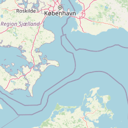
Map view of Dybsø Fjord

Use this park location map to pinpoint Dybsø Fjord in Denmark, understand its exact geographic position, and read its mapped placement within the surrounding landscape more clearly.

Pigeon | © OpenStreetMap contributors
Park atlas

Compare nearby coastal reserves and wetland habitats in the surrounding region.

Parks Near Dybsø Fjord and Protected Landscapes Across Southern Zealand

Browsing other protected areas near Dybsø Fjord reveals the broader ecological patterns of coastal Zealand. Evaluating adjacent wetland reserves and shallow marine basins provides valuable context for regional conservation geography.
A horizontal watercolor painting showing a soft green shoreline in the foreground and rolling hills across the water in the distance.
Nature reserveNaestved Municipality
About 1.6 km away#1 closest

West

Dybsø Nature Reserve: Protected Coastal Landscape in Naestved Municipality

Geographic atlas of a protected Danish barrier island

Dybsø is a distinct barrier island situated off the coast of Zealand. Its protected landscape consists of open grasslands, coastal reed beds, and freshwater ponds that shelter the shallow waters of the fjord system. As a designated nature reserve, the area represents a critical wildlife refuge, maintained through traditional grazing to preserve its unique maritime terrain and geological history.

Area
1.34 km²
Established
1978
Relief
Lowland
Climate
Temperate
Nature reserveDenmark
About 30 km away#2 closest

West

Stigsnæs-Borreby-Basnæs Nor Nature Reserve: Mapped Geography and Coastal Landscape Context

Protected wetlands and migration corridors in southern Denmark

Stigsnæs-Borreby-Basnæs Nor encompasses a complex interplay of manor-influenced farmland, reed-fringed shallows, and essential marshlands. This nature reserve functions as a critical funnel for migratory raptors and waterfowl on the southwestern edge of the Zealand coast. The area integrates deep cultural history with internationally recognized habitats, offering a clear window into the coastal terrain and wetland structure of the region.

Area
12.15 km²
Established
1978
Relief
Lowland
Scope
Mixed
Nature reserveFaxe Municipality
About 32 km away#3 closest

Northeast

Bagholt Mose: Protected Peatland Mosaic and Fen Geography in Faxe Municipality, Denmark

A high-value Natura 2000 protected wetland and bog habitat.

Bagholt Mose is a significant nature reserve situated within the Munkeskov forest of southern Zealand. The landscape features a distinct combination of historical peat cuttings and raised bog remnants, which together form a rare mosaic of nutrient-poor and calcareous fen communities that support an exceptional diversity of lowland bog flora.

Area
0.17 km²
Established
1985
Relief
Lowland
Scope
Terrestrial
A soft watercolor painting depicting a calm lake surrounded by lush green trees and soft, rolling hills in the background.
Protected landscapeLolland
About 45 km away#4 closest

South

Naturpark Maribosøerne Protected Landscape and Glacial Geography in Denmark

Glacial lake ecosystems on the island of Lolland

The landscape of Naturpark Maribosøerne centers on four interconnected glacial lakes, characterized by twisting shorelines and shallow, nutrient-rich water. This protected area on Lolland blends ancient ice age terrain with historic manor estates, extensive wetlands, and managed forest zones. Its formal status as a Natura 2000 habitat and bird protection zone highlights the ecological importance of this unique southern Danish environment.

Area
11.4 km²
Established
1957
Water
Major water bodies
Nature reserveSolrød Kommune
About 52 km away#5 closest

Northeast

Staunings Ø Nature Reserve: Exploring the Coastal Geomorphology of Solrød Kommune

A mapped barrier spit and wetland habitat on the eastern Zealand shoreline.

Staunings Ø functions as a textbook example of a coastal sand bar accretion in the shallow waters of Køge Bugt. This nature reserve protects a vital sequence of dunes, lagoons, and reedbeds that provide a clear view of coastal succession. Located near the urban edge of Solrød Kommune, it serves as a key site for understanding the interaction between natural coastal landforms and maritime environments in eastern Denmark.

Area
0.6 km²
Established
1999
Relief
Lowland
Climate
Temperate
A soft watercolor illustration showing a hazy green landscape with rolling hills, a line of trees, and a calm body of water in the foreground.
Nature reserveKalundborg Municipality
About 58 km away#6 closest

Northwest

Flasken Nature Reserve: Mapped Protected Landscapes in Kalundborg Municipality

Coastal river mouths and brackish lagoon ecology

Flasken stands as a significant protected nature reserve in western Denmark, defined by the confluence of the Halleby Å river and the Storebælt. This mapped landscape provides essential context for understanding the long-term coastal geomorphology of the Reersø tombolo and the wider wetland ecosystems of the Åmosen basin.

Established
1979
Relief
Lowland
Climate
Temperate
Access
Access unknown
A watercolor painting of a rolling coastal landscape with green fields, sparse trees, a winding water channel, and soft pink and yellow sky.
Nature reserveLolland
About 61 km away#7 closest

South

Saksfjed-Hyllekrog Nature Reserve: Coastal Geography and Protected Landscapes of Southern Lolland

Mapped protected wetlands, coastal spits, and polder terrain in southern Denmark.

The Saksfjed-Hyllekrog nature reserve protects a mosaic of woodland, coastal meadows, and shorelines on the southern coast of Lolland. This geographic record details the reserve's polder embankments, the Hyllekrog coastal spit, and the interaction between reclaimed land and open marine waters, highlighting its importance as a Ramsar and Natura 2000 site.

Area
2.174 km²
Established
1995
Relief
Lowland
Climate
Temperate
Nature reserveKalundborg Municipality
About 69 km away#8 closest

Northwest

Saltbæk Vig Nature Reserve: Geography and Protected Wetland Landscapes in Kalundborg Municipality

A brackish lagoon basin shaped by historic land reclamation efforts.

Saltbæk Vig is a major coastal water body on the northwestern edge of Zealand, Denmark, defined by shallow waters and low-lying wetland terrain. This nature reserve serves as an important regional landmark, where historic drainage embankments now form unique boundaries that define the lagoon's ecological character and protected status.

Area
26 km²
Established
1992
Relief
Lowland
Climate
Temperate

Common questions about visiting, size, designation, and location context for Dybsø Fjord

Dybsø Fjord FAQs for park facts, access, geography, and protected area context

Find quick answers about Dybsø Fjord, including protected-area facts, park geography, trail and visitor context, and how the park fits into its surrounding country and regional landscape.
MoriAtlas Explorer

Continue Your Protected Areas Search Across the Global Atlas

Deepen your exploration by continuing the structured search for national parks and protected areas worldwide. Utilize the comprehensive filtering capabilities to compare different conservation landscapes and refine your understanding of global park geography. Discover more about the distribution and characteristics of protected natural areas.

Global natural geography