Mori Atlas logo
Wildlife reserveEagles Nest Wilderness

Discover the mapped boundaries and high-elevation terrain of this expansive Colorado wildlife reserve

Eagles Nest Wilderness: Mapping the Protected Alpine Landscapes of the Colorado Gore Range

Spanning the rugged spine of the southern Gore Range in Colorado, Eagles Nest Wilderness serves as a protected sanctuary of high-alpine peaks, glacially carved cirque lakes, and deep subalpine valleys. This wildlife reserve encompasses a complex network of forested ridges and tundra basins, preserving both natural mountain ecosystems and a layered record of nineteenth-century mining history across its vast, protected acreage.

alpine wildernessGore RangeRocky Mountainshigh-elevation hikingglacial lakeswhite river national forest

Eagles Nest Wilderness

Wildlife reserve

Park overview

Structured park overview, official facts, and landscape profile for Eagles Nest Wilderness

Eagles Nest Wilderness park facts, protected area profile, and essential visitor context

Review the core facts for Eagles Nest Wilderness, including designation, size, terrain, visitor scale, habitats, and operating context in one park-focused overview.

About Eagles Nest Wilderness

Eagles Nest Wilderness occupies a substantial portion of the southern Gore Range, a long, narrow Rocky Mountain spine that runs roughly north to south through Eagle and Summit Counties in central Colorado. The wilderness sits within the broader White River National Forest, one of the most heavily visited national forests in the United States, yet the protected area itself remains a quiet, roadless expanse of high country. Surrounding communities such as Vail, Copper Mountain, Frisco, Silverthorne, and Heeney serve as gateway towns, providing trailhead access into the alpine interior.

The defining physical character of Eagles Nest is its elevation. The wilderness rises well above timberline in many areas, with sharp ridgelines, broad U-shaped valleys shaped by past glaciation, and clusters of cirque lakes tucked beneath snowfields and rock faces. Peaks such as Mount Powell and Eagles Nest anchor the skyline, while lower elevations support dense conifer forest, riparian creek corridors, and meadow systems. This vertical range produces distinct ecological zones stacked atop one another, from montane forest near the valley bottoms to alpine tundra and bare rock near the summits.

Trails lace the wilderness in a network that totals roughly 180 miles. Routes such as the Gore Range Trail, Upper Piney Lake Trail, Booth Creek Trail, Pitkin Creek Trail, and Rock Creek Trail connect the main trailheads with remote lakes and basins. Visitors come for day hikes to glacially carved lakes as well as multi-day backpacking routes that traverse long stretches of the range. Despite its proximity to popular resort towns, the wilderness retains a strong sense of solitude.

Beyond its natural character, Eagles Nest Wilderness preserves traces of the area's human history. The Gore Range takes its name from Sir George Gore, whose nineteenth-century hunting expedition, guided by the trapper Jim Bridger, passed through these mountains. The same landscape later drew miners seeking gold and silver, leaving behind diggings, tailings, and small ruin sites such as the former Boss Mine along Rock Creek Trail. Together, the wilderness offers a layered landscape of alpine scenery, ecological diversity, and visible echoes of Colorado's mining past.

Quick facts and research context for Eagles Nest Wilderness

Eagles Nest Wilderness spans the southern Gore Range in central Colorado, covering about 135,000 acres across Eagle and Summit Counties. It is part of the White River National Forest and is managed by the U.S. Forest Service under an IUCN Category Ib wilderness designation.

The wilderness was officially designated in the late 1970s and includes nearly 180 miles of trails. Its two highest points are Mount Powell, at 13,586 feet, and the peak called Eagles Nest, at 13,419 feet. The area sits near several well-known Colorado mountain communities, including Vail and Silverthorne, making it a notable high-country preserve in the broader Rocky Mountain system.

Protection and recognition

Documented terrestrial conservation scope and official designation records

Eagles Nest Wilderness Protection Status and International Recognition

Eagles Nest Wilderness maintains a documented terrestrial protection scope without imported international recognition sources. Official conservation records outline the baseline management framework and administrative status for this protected landscape.

Protection details

Protection scope
Terrestrial
Transboundary protection
No
Park context

Deeper park guide and search-rich context for Eagles Nest Wilderness

Eagles Nest Wilderness history, landscape, wildlife, and travel context

Explore Eagles Nest Wilderness through its history, landscape character, ecosystems, wildlife, conservation priorities, cultural context, and seasonal travel timing in a structured park guide built for atlas discovery and search intent.

Why Eagles Nest Wilderness stands out

Eagles Nest Wilderness is known for the dramatic high-alpine scenery of the southern Gore Range, with steep peaks, expansive vistas, and clusters of glacial cirque lakes. Hikers are drawn to destinations such as the Upper Piney Lake, Mirror Lake, Booth Creek, and Pitkin Creek areas, each framed by the range's granite ridges and clear subalpine forest. The wilderness is also recognized for its network of long-distance trails that connect remote basins and passes, making it a favored destination for serious backpackers exploring Colorado's Rockies. Layered into this natural scenery is the area's mining heritage, evidenced by scattered mine tailings and ruins that add a historical dimension to the wilderness experience.
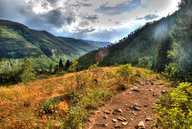
A dirt hiking trail leads through golden meadows and green mountain slopes under a cloudy sky.
A rugged hiking trail winds through the alpine meadows of the Eagles Nest Wilderness in Colorado.

Eagles Nest Wilderness history and protected-area timeline

The Eagles Nest Wilderness takes its name from one of the range's most prominent peaks and was formally designated in the late 1970s as part of the U.S. Wilderness system. Its establishment was the culmination of broader efforts during that era to protect representative stretches of Colorado's high country from road-building, logging, and expanding development. Today the wilderness is managed within the White River National Forest under the principles of the U.S. Wilderness preservation system, which emphasizes minimal human impact and the retention of wild character.

The mountains that the wilderness protects have a long human history that predates their protected status. The Gore Range was named for Sir George Gore, an Irish nobleman whose 1854 hunting expedition was guided by Jim Bridger, one of the most famous mountain men of the nineteenth century. Bridger had documented the Great Salt Lake in 1824 and played a role in shortening the Oregon Trail through Bridger Pass in 1850. Gore's expedition, which included more than thirty wagons and dozens of attendants, traveled from Fort Leavenworth through the central Colorado mountains and eventually into the Yellowstone region. The group left a heavy mark on the landscape, including extensive hunting of large game animals across thousands of miles of terrain.

Mining soon followed. Rumors of gold associated with the Ute people, who inhabited the region before Euro-American expansion, attracted prospectors to the Gore Range. A member of the Gore expedition is reported to have found gold near Piney Lake, north of present-day Vail, and other travelers, including members of the Bela M. Hughes party, recorded similar finds. By the latter half of the nineteenth century, the range was dotted with shallow prospect holes, diggings, and small workings such as the Boss Mine, whose ruins remain visible along the Rock Creek Trail. These mining features are now part of the cultural landscape preserved within the wilderness.

In more recent decades, conservation efforts have continued to shape the area. In 2010, a proposal known as the Hidden Gems initiative sought to add additional lands to wilderness protection, affecting areas such as Elliot Ridge, Tenmile, and Lower Piney in Summit and Eagle Counties. These efforts reflect ongoing debate about how best to preserve the highest and most sensitive portions of the central Rockies while accommodating recreation, wildlife habitat, and the popularity of surrounding mountain communities.

Eagles Nest Wilderness landscape and geographic character

Eagles Nest Wilderness follows the spine of the southern Gore Range, a long, rugged Rocky Mountain crest that drops steeply on either side into forested valleys. The terrain is dominated by high, glacially sculpted peaks, sharp ridgelines, and deep U-shaped valleys that descend toward the Blue River and Gore Creek drainages. Two of the most prominent summits are Mount Powell, at 13,586 feet, and Eagles Nest peak, at 13,419 feet, both of which tower above much of the surrounding terrain.

The lower valleys are cloaked in conifer forest, with creeks such as Booth Creek, Pitkin Creek, Rock Creek, and Gore Creek threading through meadows and willow flats. Above the trees, the mountains open into broad alpine basins and tundra slopes studded with rock. Glacial scouring has left behind numerous cirques, many of which now hold clear, cold lakes such as Upper Piney Lake, Mirror Lake, and the Eaglesmere Lakes. The combination of steep rock, deep lakes, and layered forest gives the wilderness its classic Rocky Mountain character.

Eagles Nest Wilderness ecosystems, habitats, and plant life

The ecological character of Eagles Nest Wilderness is shaped primarily by elevation and relief. The lower elevations support montane and subalpine coniferous forest dominated by spruce, fir, and pine, with occasional aspen stands in transitional zones. Mid-elevation slopes often include dense forest cover interspersed with meadows and willow thickets along creeks, providing important habitat for a range of wildlife.

Above tree line, the wilderness gives way to alpine tundra, bare rock, and persistent snowfields. These high-elevation environments are relatively fragile and recover slowly from disturbance. Cirque lakes and alpine meadows contribute to the hydrology of the surrounding valleys, feeding the creeks that descend into the White River basin. Together, these stacked ecological zones create an important gradient of habitat types within a relatively compact area.

Eagles Nest Wilderness wildlife and species highlights

The wilderness supports a typical complement of central Colorado high-country wildlife. Larger mammals such as mule deer and elk are present in forested and meadow habitats, while mountain habitats are home to bighorn sheep in appropriate terrain. Black bears inhabit the forested slopes, and smaller mammals such as marmots, pikas, and various squirrels occupy the rocky alpine zones and talus fields.

Birds include raptors such as golden eagles and other species adapted to cliffs and open ridgelines, as well as typical forest songbirds. Wet meadows and willow wetlands around creeks and lakes provide habitat for waterfowl and shorebirds during the warmer months. As in many Colorado wildernesses, wildlife observation depends largely on the season and elevation, with summer being the most active period for most species.

Eagles Nest Wilderness conservation status and protection priorities

Eagles Nest Wilderness is protected under the U.S. National Wilderness Preservation System, a designation that restricts road construction, motorized use, logging, mining, and most forms of development in order to preserve the area's wild character. Management by the U.S. Forest Service emphasizes minimal-impact recreation, with rules designed to protect fragile alpine soils, vegetation, and water resources.

The wilderness contributes to broader conservation goals for the Gore Range and the White River National Forest by maintaining large, ecologically intact stretches of high-elevation habitat that connect to surrounding protected and roadless areas. Its lakes, creeks, and snowpack also function as part of the regional watershed, supplying water to downstream communities. Past and ongoing proposals, such as the 2010 Hidden Gems initiative, reflect continued interest in expanding wilderness protection around the existing Eagles Nest boundaries.

Eagles Nest Wilderness cultural meaning and human context

The Gore Range and the Eagles Nest Wilderness carry a layered human history. Long before sustained Euro-American presence, the area was part of the broader territory of the Ute people, whose knowledge of the mountains and resources contributed to early reports of mineral deposits in the region. The area's name, and the broader cultural memory of the Gore Range, is tied to Sir George Gore's 1854 expedition and to mountain men like Jim Bridger, whose travels shaped nineteenth-century understanding of the American West.

Mining culture forms another important layer. Small-scale prospectors and later organized mining ventures left behind diggings, tailings, and ruins throughout the range, including the Boss Mine along Rock Creek Trail. These features are now part of the cultural landscape within the wilderness, offering visitors an opportunity to encounter the remnants of Colorado's mining past alongside its natural scenery.

Top sights and standout views in Eagles Nest Wilderness

Eagles Nest Wilderness's standout features include the long, rugged spine of the southern Gore Range, the dramatic cirque lakes such as Upper Piney Lake and Mirror Lake, and the extensive trail network that stitches together alpine basins and passes. Mount Powell and Eagles Nest peak provide the most recognizable high points, while the wilderness's proximity to Vail, Silverthorne, and other mountain resorts enhances its role as a premier Colorado hiking destination.

The mix of alpine scenery, glacial lakes, expansive forest, and visible mining history gives the wilderness a layered character that rewards both casual hikers and experienced backpackers.

Best time to visit Eagles Nest Wilderness

The most favorable window for visiting Eagles Nest Wilderness is summer, when snow has melted from most trails and the high country is accessible. Summer days at lower trailheads can be mild and pleasant, with overnight temperatures dropping sharply at higher elevations. Wildflowers typically bloom in mid to late summer in the alpine zones, and the cirque lakes are at their most accessible.

Outside of summer, conditions become considerably harsher. Winter and early spring bring deep snow, subfreezing temperatures, and avalanche risk in steep terrain, and many high trails become practical only for experienced mountaineers with appropriate gear. Late spring can be a transitional period, with lower trails opening while higher routes remain snowbound. In general, visitors who prefer quieter conditions and are prepared for cooler weather may find the shoulder seasons rewarding, while those seeking full alpine access tend to arrive in mid to late summer.

Monthly climate preview

Long-term monthly temperature and precipitation averages across representative high-elevation terrain

Eagles Nest Wilderness Climate Normals, Annual Temperature and Precipitation Rhythm

Eagles Nest Wilderness exhibits a measured annual temperature range from deep sub-zero winter minimums to mild summer highs alongside steady monthly precipitation rates. Exploring the complete twelve-month climate profile reveals detailed monthly averages across the representative coordinate.
Annual mean-1 °C
-12 °C13 °C
Jan-12°
Feb-12°
Mar-8°
Apr-3°
May
Jun
Jul13°
Aug11°
Sep
Oct
Nov-7°
Dec-12°
Warmest month
July

12.7 °C

Coolest month
January

-12.5 °C

Wettest month
April

2.2 mm/day

Driest month
June

1.1 mm/day

Park location guide

Geography guide, regional context, and park location map for Eagles Nest Wilderness

Eagles Nest Wilderness park geography, regions, and map view in United States of America

Understand where Eagles Nest Wilderness sits in United States of America through a broader geographic reading of the surrounding landscape, nearby location context, and its mapped position within the national park landscape.

How Eagles Nest Wilderness fits into United States of America

The United States of America is a federal presidential republic and one of the world's largest countries by area and population. It consists of 50 states across a vast territory spanning multiple time zones, with its capital in Washington, D.C. and largest city in New York City. The nation has a diverse economy, influential political system, and significant cultural and military presence globally.

Wider geography shaping Eagles Nest Wilderness in United States of America

The United States occupies a vast territory in North America, bordered by Canada to the north and Mexico to the south. The 48 contiguous states stretch from the Atlantic to the Pacific Ocean, while Alaska occupies the northwestern region and Hawaii is an archipelago in the Pacific. The country encompasses diverse terrain including the Rocky Mountains, Appalachian Mountains, Great Plains, and extensive river systems.

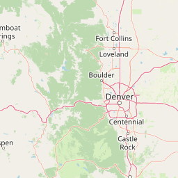
Map view of Eagles Nest Wilderness

Use this park location map to pinpoint Eagles Nest Wilderness in United States of America, understand its exact geographic position, and read its mapped placement within the surrounding landscape more clearly.

Pigeon | © OpenStreetMap contributors

Location context for Eagles Nest Wilderness

Colorado
Recorded earthquake history

Review Recorded Earthquake History for Eagles Nest Wilderness

Browse the comprehensive catalogue of seismic records associated with the Eagles Nest Wilderness terrain. MoriAtlas provides a clear, data-focused look at historical earthquake locations and magnitudes near the Gore Range, offering a reliable reference for understanding regional seismic history without predictive intent or hazard assessment.

Eagles Nest Wilderness Earthquake History

Catalogued events

2 events

Strongest magnitude

Magnitude 3.4

Most recent event

Aug 21, 2012

This history includes earthquakes recorded inside the park or within 50 km of its borders

Visual reference for the protected landscape, granite peaks, and glacial lakes

Eagles Nest Wilderness Photos and Scenery: Exploring Alpine Landscapes

Photographic records reveal the dramatic alpine terrain, glacial cirque lakes, and rugged granite ridges defining the southern Gore Range. Visual documentation helps researchers and visitors examine the high-elevation habitats and protected wilderness character more closely.

A dirt hiking trail leads through golden meadows and green mountain slopes under a cloudy sky.

Park atlas

Compare surrounding mountain landscapes and regional protected areas in the Rocky Mountains

Other Parks and Protected Areas Near Eagles Nest Wilderness

Browsing other protected areas near Eagles Nest Wilderness reveals the wider regional spread of alpine terrain and high elevation ecosystems. Comparing adjacent mountain parks helps map connected wilderness corridors across the surrounding Rocky Mountain ranges.
Wildlife reserveColorado
13 km away#1 closest

Southwest

Holy Cross Wilderness: Mapped Alpine Landscapes and Colorado Protected Areas

Glacial valleys and high-country geography in the Sawatch Range

Discover the geographic layout of the Holy Cross Wilderness, a vital protected area in central Colorado. This resource details the rugged Sawatch Range environment, from high alpine lake basins to the iconic northern couloirs of its namesake mountain, offering a clear view of the park boundaries and surrounding high-country terrain.

Area
496.94 km²
Established
1980
IUCN
Ib
Relief
Mountain
Watercolor painting of a serene mountain landscape featuring rolling hills, coniferous trees, and a lake in the foreground, rendered in light pastel tones.
Protected landscapeColorado
14 km away#2 closest

Southeast

San Isabel National Forest: Geographic Overview and Protected Mountain Landscape Atlas

Central Colorado alpine terrain and designated wilderness areas

Spanning eleven counties in central Colorado, San Isabel National Forest serves as a cornerstone of the Southern Rocky Mountains. The forest landscape is dominated by the Sawatch and Sangre de Cristo ranges, offering a unique atlas of alpine tundra, dense coniferous forests, and high-altitude peaks that define the character of the region. This protected area provides a vital habitat and a vast, rugged environment characterized by volcanic formations like the Spanish Peaks and glacial geological features.

Area
4,533.42 km²
Established
1902
Relief
Mountain
Climate
Alpine
A soft watercolor illustration depicting a simplified, layered landscape of rolling hills and distant mountains in shades of light green, pale yellow, and soft pink.
Protected areaColorado
14 km away#3 closest

Southeast

Pike National Forest: Protected Mountain Landscapes and Regional Geography in Central Colorado

Granite peaks, montane forests, and diverse alpine terrain

Spanning from the rolling foothills of the Front Range to the high alpine summits of the Rocky Mountains, Pike National Forest is a significant protected area defined by its unique Pikes Peak granite bedrock and deep river-carved canyons. This analysis provides a structured look at its expansive wilderness boundaries, drainage basins, and the vertical transitions that characterize this vital central Colorado highland.

Area
4,478.27 km²
Established
1892
Relief
Mountain
Climate
Alpine
A watercolor painting showing purple and white mountain peaks rising above green rolling hills and meadows in a wide panoramic format
Protected areaColorado
32 km away#4 closest

East

Mount Evans Wilderness: Alpine Landscapes and Protected Geography in Colorado

Glacial cirques and high-altitude wilderness ecosystems.

Mount Evans Wilderness offers a premier look at the Colorado Front Range, defined by its dramatic relief, sheer cliff lines, and extensive glacial history. This entry examines the wilderness as a protected zone that transitions from montane forests to tundra, providing a reference for high-elevation mountainous geography within the United States.

Area
301.09 km²
Established
1980
IUCN
Ib
Relief
Mountain
A horizontal watercolor painting showing layers of pale green and soft pink mountain ridges behind a foreground of simple green and purple evergreen tree shapes.
Wildlife reserveColorado
35 km away#5 closest

South

Mount Massive Wilderness: A Protected Alpine Landscape in the Colorado Sawatch Range

High-altitude wilderness geography and Continental Divide terrain.

Mount Massive Wilderness represents a critical protected landscape in the central Colorado Rockies, encompassing glacially carved valleys, alpine tundra, and the second-highest peak in the state. This wilderness area provides a window into the rugged vertical relief and subalpine ecosystems that define the high-altitude geography surrounding Leadville, anchored by the iconic Sawatch Range and Continental Divide.

Area
123.6 km²
Established
1980
IUCN
Ib
Relief
Mountain
Protected landscapeColorado
About 39 km away#6 closest

East

White River National Forest: Mapping the Protected Landscapes and High Country of Central Colorado

Regional geography, wilderness boundaries, and mountain terrain data

Spanning from the high alpine tundra of the Sawatch Range to the volcanic plateaus of the Flat Tops, White River National Forest represents a significant protected area in the American West. This detail presents the geographic footprint, forest landscape, and complex mountain terrain that define this vital Colorado territory.

Area
9,251 km²
Established
1902
Relief
Mountain
Climate
Alpine
A watercolor painting showing a panoramic view of mountain peaks in the background behind a forest landscape, set against a white background.
Wildlife reserveColorado
About 41 km away#7 closest

East

James Peak Wilderness: Geographic Profile and Protected Landscape Mapping

High elevation terrain in the Colorado Rockies

James Peak Wilderness provides a critical protected landscape featuring dramatic alpine summits, U-shaped glacial valleys, and subalpine meadows. Its geographic structure forms an essential ecological link along the Colorado Front Range, characterized by high-elevation peaks, dense coniferous forests, and diverse tundra ecosystems situated immediately east of the Continental Divide.

Area
68.86 km²
Established
2002
IUCN
Ib
A horizontal watercolor painting showing a range of purple and reddish-toned mountains in the distance, behind rolling green fields and a pale pinkish waterway in the foreground.
Protected landscapeColorado
43 km away#8 closest

Northeast

Roosevelt National Forest: Mapping Wilderness and Protected Landscapes in Northern Colorado

Regional geography, river corridors, and alpine mountain terrain

Roosevelt National Forest encompasses a significant protected landscape across Larimer, Boulder, Gilpin, and Jefferson counties. The forest features a complex terrain of deep canyons, forested plateaus, and protected wilderness areas that form a scenic buffer along the eastern side of the Continental Divide and Rocky Mountain National Park.

Area
3,293.33 km²
Established
1902
Relief
Mountain
Climate
Subpolar

Common questions about visiting, size, designation, and location context for Eagles Nest Wilderness

Eagles Nest Wilderness FAQs for park facts, access, geography, and protected area context

Find quick answers about Eagles Nest Wilderness, including protected-area facts, park geography, trail and visitor context, and how the park fits into its surrounding country and regional landscape.
MoriAtlas Explorer

Continue Your Protected Areas Search Across the Global Atlas

Deepen your exploration by continuing the structured search for national parks and protected areas worldwide. Utilize the comprehensive filtering capabilities to compare different conservation landscapes and refine your understanding of global park geography. Discover more about the distribution and characteristics of protected natural areas.

Global natural geography