

Mori Atlas logo
Nature reserveEechelbuer-Lock

A distinct sandstone plateau in the Noumer region balancing prehistoric human history with protected heathland habitats.

Eechelbuer-Lock: Mapping the Sandstone Plateau, Archaeological Heritage, and Protected Natural Landscapes

(Naturschutzgebitt Eechelbuer-Lock)

Eechelbuer-Lock represents a unique convergence of protected natural habitat and ancient cultural history situated on a prominent sandstone plateau. This nature reserve, located within the municipality of Noumer in central Luxembourg, features an open mosaic of juniper-dotted heathland and over 40 distinct sandstone boulders. The area is globally recognized for the mushroom-shaped Champignon rock formation, a geological testament to differential weathering, while archaeological records spanning from Mesolithic camps to Roman-era quarries confirm the site has served as a significant human focal point for over 10,000 years.

sandstone plateauarchaeological siteprehistoric sitenature reserveNatura 2000FFH area

Eechelbuer-Lock

Nature reserve

Park overview

Structured park overview, official facts, and landscape profile for Eechelbuer-Lock

Eechelbuer-Lock park facts, protected area profile, and essential visitor context

Review the core facts for Eechelbuer-Lock, including designation, size, terrain, visitor scale, habitats, and operating context in one park-focused overview.

About Eechelbuer-Lock

Eechelbuer-Lock is a compact, multi-layered protected landscape in central Luxembourg, situated northwest of the village of Eechelbuer in the commune of Nommern. The name "Lock" derives from an old term for a wet depression or body of water, reflecting that the plateau may once have had different hydrological conditions. Today the area is recognized simultaneously as a nature reserve (Naturschutzgebitt), a water protection zone (Waasserschutzgebitt), a Natura 2000 Fauna-Flora-Habitat area, and a classified national monument, making it one of the few Luxembourgish sites where natural and cultural heritage protections fully overlap.

The defining geographical feature is an open sandstone plateau roughly 350 meters above sea level, lying along the CR119 between Schrondweiler and Fiels. The plateau has a trapezoidal shape with sides of approximately 190, 120, 160, and 65 meters, and across it some 40 sandstone blocks of varying shape and size are scattered. To the east the open landscape transitions into forest, while to the west and southwest it overlooks the Alzette valley and the area around Helperknapp. In the northeast, only the edge of the Beaufort Plateau becomes visible on the horizon. Geologically, the Lock consists of Luxembourg Sandstone covered by a thin layer of diluvial deposits, a combination that creates both the distinctive boulder field and the dry, nutrient-poor soils that support heath and juniper vegetation.

The site's fame rests largely on the "Champignon", a mushroom-shaped rock whose lower sandstone layers are softer than the upper ones, allowing differential weathering to produce a clear pedestal cap beneath a heavier top. Across the area, archaeologists and visitors have also identified numerous other boulders carrying grinding grooves, hollows, quarry marks, cupules, and symbolic engravings. Together, the unusual geology, the visible traces of ancient stoneworking, the protected heath and juniper habitats, and the prehistoric occupation evidence combine to give Eechelbuer-Lock a depth unusual even for a region like the Mellerdall, which is already rich in sandstone heritage.

Quick facts and research context for Eechelbuer-Lock

Eechelbuer-Lock lies in the municipality of Nommern in central Luxembourg, between the villages of Schrondweiler and Fiels along the CR119 road. The area is officially recognized as a nature reserve, a water protection zone, and a Natura 2000 FFH (Fauna-Flora-Habitat) site, reinforcing its value for both biodiversity and water quality.

The site has been a classified monument of Luxembourg since 20 November 1972, reflecting its dual archaeological and natural significance. Its most famous geological feature is the "Champignon" mushroom rock, a unique sandstone formation whose softer lower strata have been eroded away over time. Around 40 sandstone boulders are distributed across the plateau, several of which carry prehistoric grinding grooves, tool marks, and symbolic engravings that document human activity going back to the Mesolithic period.

Protection and recognition

Review documented terrestrial protection scope and conservation frameworks for Eechelbuer-Lock.

Eechelbuer-Lock Protection Status and International Recognition Details

Eechelbuer-Lock maintains a defined terrestrial protection scope within its documented conservation framework. Official records compile available designation history and management context for thorough geographical analysis.

Protection details

Protection scope
Terrestrial
Transboundary protection
No
Park context

Deeper park guide and search-rich context for Eechelbuer-Lock

Eechelbuer-Lock history, landscape, wildlife, and travel context

Explore Eechelbuer-Lock through its history, landscape character, ecosystems, wildlife, conservation priorities, cultural context, and seasonal travel timing in a structured park guide built for atlas discovery and search intent.

Why Eechelbuer-Lock stands out

Eechelbuer-Lock is best known for the remarkable "Champignon" sandstone rock, a mushroom-shaped boulder created by differential erosion of Luxembourg sandstone. It is also widely recognized for its ancient rock engravings and prehistoric occupation sites dating back more than ten millennia. Beyond the singular rock, the plateau is notable for its trapezoidal open heathland dotted with sandstone boulders, juniper thickets, and clear traces of Mesolithic, Bronze Age, and Iron Age human activity. The convergence of geological oddity, archaeological richness, and protected semi-natural habitat defines the site's character and explains its dual designation as both nature reserve and classified monument.
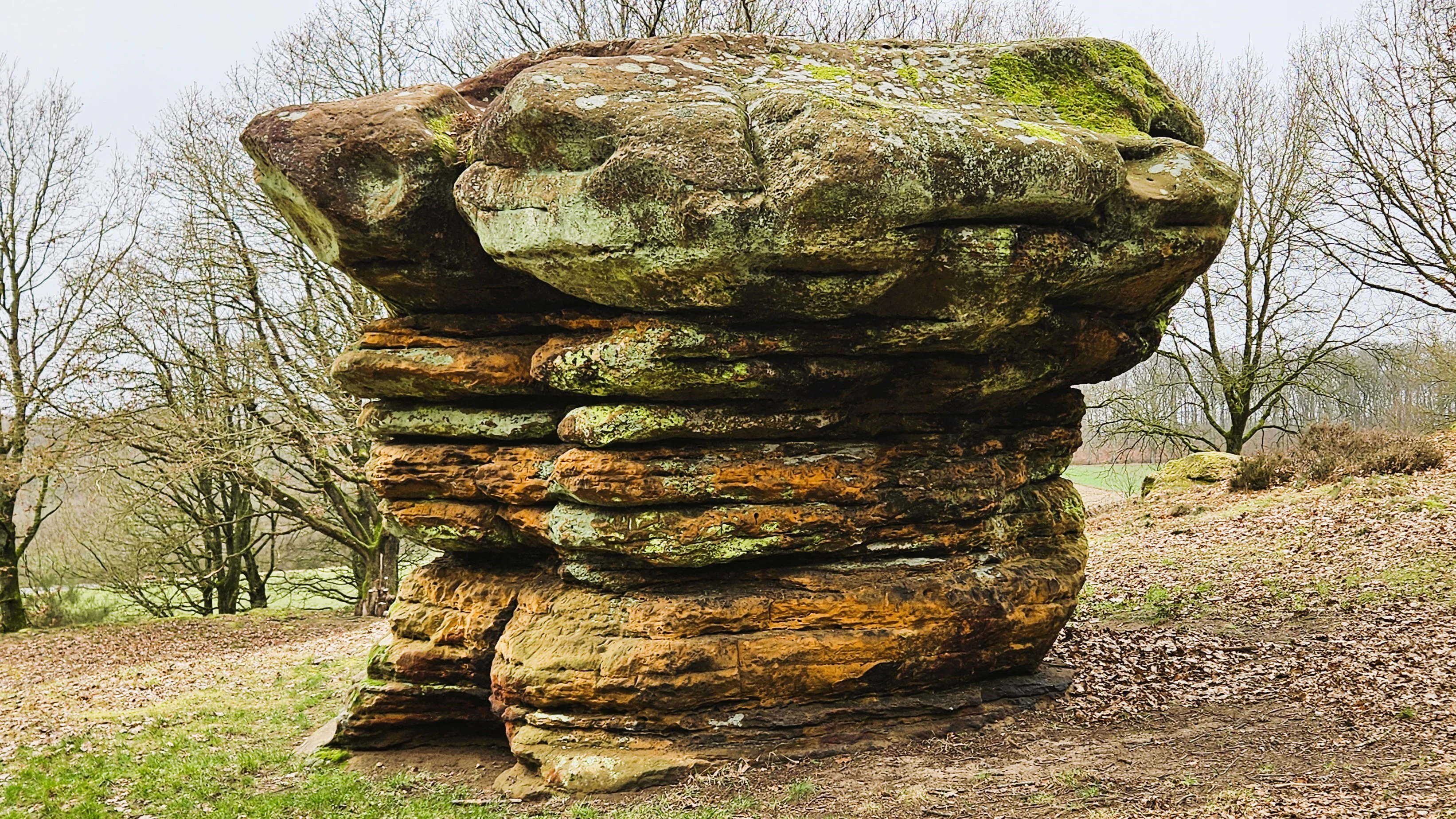
Eechelbuer-Lock Mushroom rock formation
A mushroom-shaped rock formation in the Eechelbuer-Lock nature reserve, which is also a special area of conservation, water protection zone, and archaeological site.

Eechelbuer-Lock history and protected-area timeline

The archaeological record at Eechelbuer-Lock stretches back more than 10,000 years, making the plateau one of the more continuously used prehistoric landscapes in central Luxembourg. Excavations carried out in August and September 2002 confirmed a layered sequence of human activity beginning in the Mesolithic and continuing through later prehistoric periods.

During the Middle Stone Age, between roughly 10,000 and 5,400 BCE, small flint points, scrapers, a polished quartzite tablet for grinding pigments and plant material, and flint lamellae suggest that hunter-gatherer groups used the site, possibly as a hunting camp. Toward the end of the Bronze Age (about 1250 to 750 BCE), many ceramic shards were recovered, indicating that the area belonged to the broader tradition of urnfield cremation burials that became common across the region. Visitors to the plateau can still see grinding grooves, wheel marks, scrape marks, quarry traces, cupules, and symbolic signs carved into the sandstone, showing that people have been working the stone here for at least three thousand years.

In the Iron Age the site fitted into the regional archaeological pattern of the Laufeld culture and later the Honsrück-Eifel culture, both of which are particularly known for their burial practices. Finds of ash urns and storage vessels ("dolia") indicate funerary activity at "Op de Leeën". From the Roman period onward the plateau was repurposed as a quarry, supplying sandstone for later building activity. The site's scientific documentation was significantly advanced by Ernest Schneider (1885 to 1954), whose studies of Luxembourg Sandstone engravings drew attention to Eechelbuer-Lock as an archaeological landmark. The area was formally listed as a classified monument on 20 November 1972.

Eechelbuer-Lock landscape and geographic character

Eechelbuer-Lock sits on a broad, gently elevated sandstone plateau that reaches roughly 350 meters above sea level, making it the highest point of an open ridge northwest of the village of Eechelbuer. Its trapezoidal outline has sides of approximately 190, 120, 160, and 65 meters, producing a clearly framed open space against the surrounding wooded slopes. About 40 sandstone boulders of various shapes and sizes are scattered across the surface, giving the plateau its distinctive, almost otherworldly texture.

The geological foundation is Luxembourg Sandstone capped by a thin layer of diluvial deposits. The sandstone varies in hardness across its layers, and this uneven resistance to weathering is exactly what created the famous mushroom-shaped "Champignon" rock, whose softer lower section eroded more quickly than the protective harder cap above. To the east the open plateau drops into forest, while to the west and southwest the landscape descends into the Alzette valley and the country around Helperknapp. To the northeast, beyond Miedernach, the Beaufort Plateau eventually closes the horizon.

The combination of open heath, lone sandstone blocks, juniper thickets, and long views toward the surrounding valleys gives the Lock a striking contrast between exposed rock and semi-enclosed forest. This physical stage, the dry sandy soil, the scattered boulders, and the long-distance vistas, is what makes the plateau visually remarkable and also explains why prehistoric people repeatedly chose it as a gathering, ritual, and resource site.
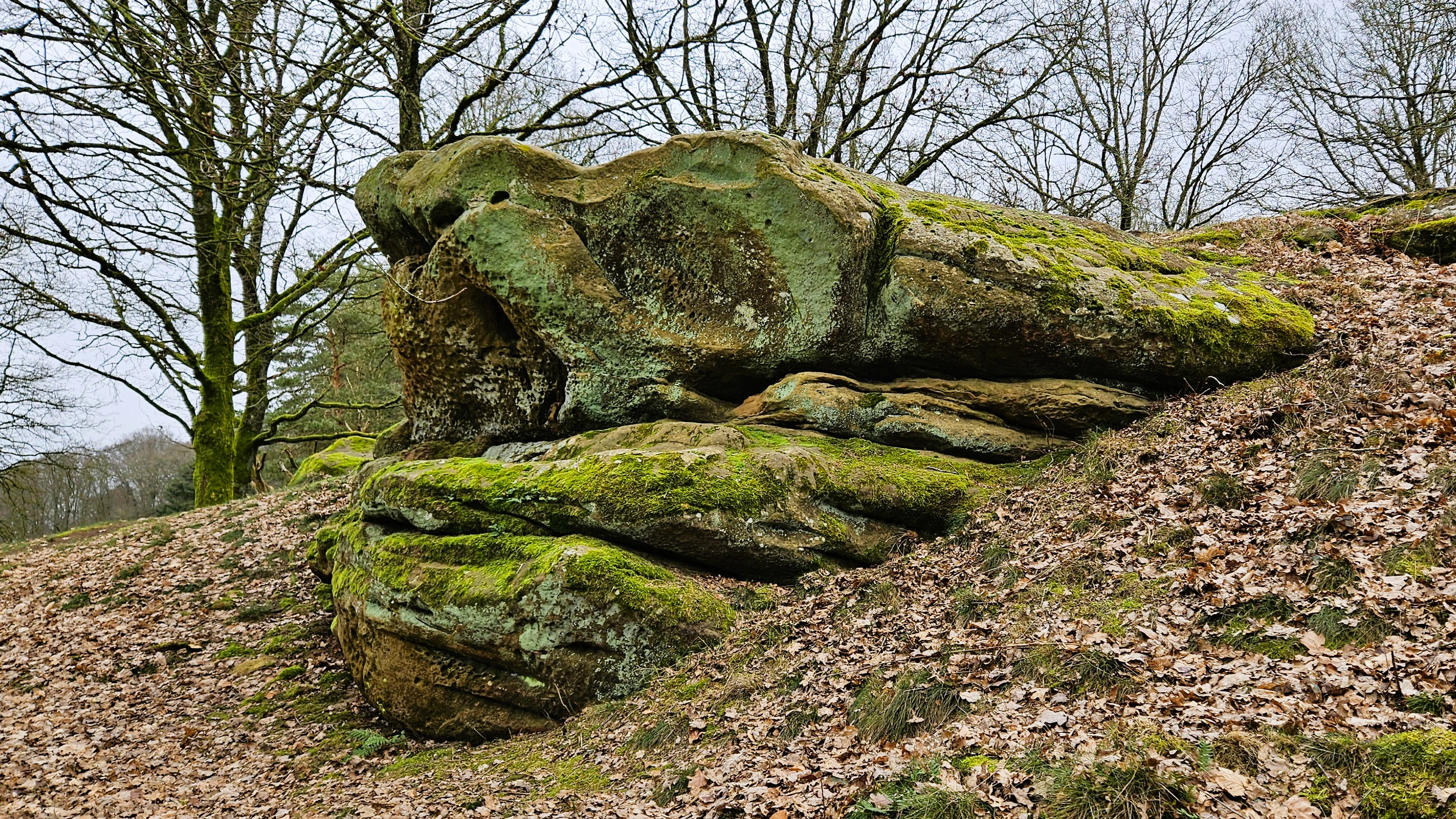
Eechelbuer-Lock Nature Reserve
A nature reserve, special area of conservation, water protection zone, and archaeological protection area in Nommern.

Eechelbuer-Lock ecosystems, habitats, and plant life

The natural character of Eechelbuer-Lock is defined by its dry, nutrient-poor sandstone soils, which support a mosaic of heathland, juniper scrub, and forest edge rather than closed woodland. Across the plateau, dense juniper hedges are particularly noticeable in the southern part, while the remaining surface is covered by heather or only sparsely vegetated, leaving the sandstone boulders prominently exposed.

This semi-open plant composition is typical of sandstone landscapes in the Mellerdall region and contributes directly to the biodiversity value that earned the site its formal designations. The area is officially a nature reserve (Naturschutzgebitt), a water protection zone (Waasserschutzgebitt), and a Fauna-Flora-Habitat site under the European Natura 2000 network. These protections recognize both the distinctive dry heath and juniper habitats and the importance of safeguarding groundwater and surface water quality in the surrounding catchment.

The interplay between exposed rock, juniper thickets, dry heath vegetation, and nearby forest creates a moderate microclimatic gradient across a relatively small surface. Such transitions between open and sheltered habitats are ecologically valuable in Luxembourg, hosting invertebrates, reptiles, and bird species adapted to warm, dry edges. The protection framework ensures that this combination of habitats remains intact despite the site's small overall extent.
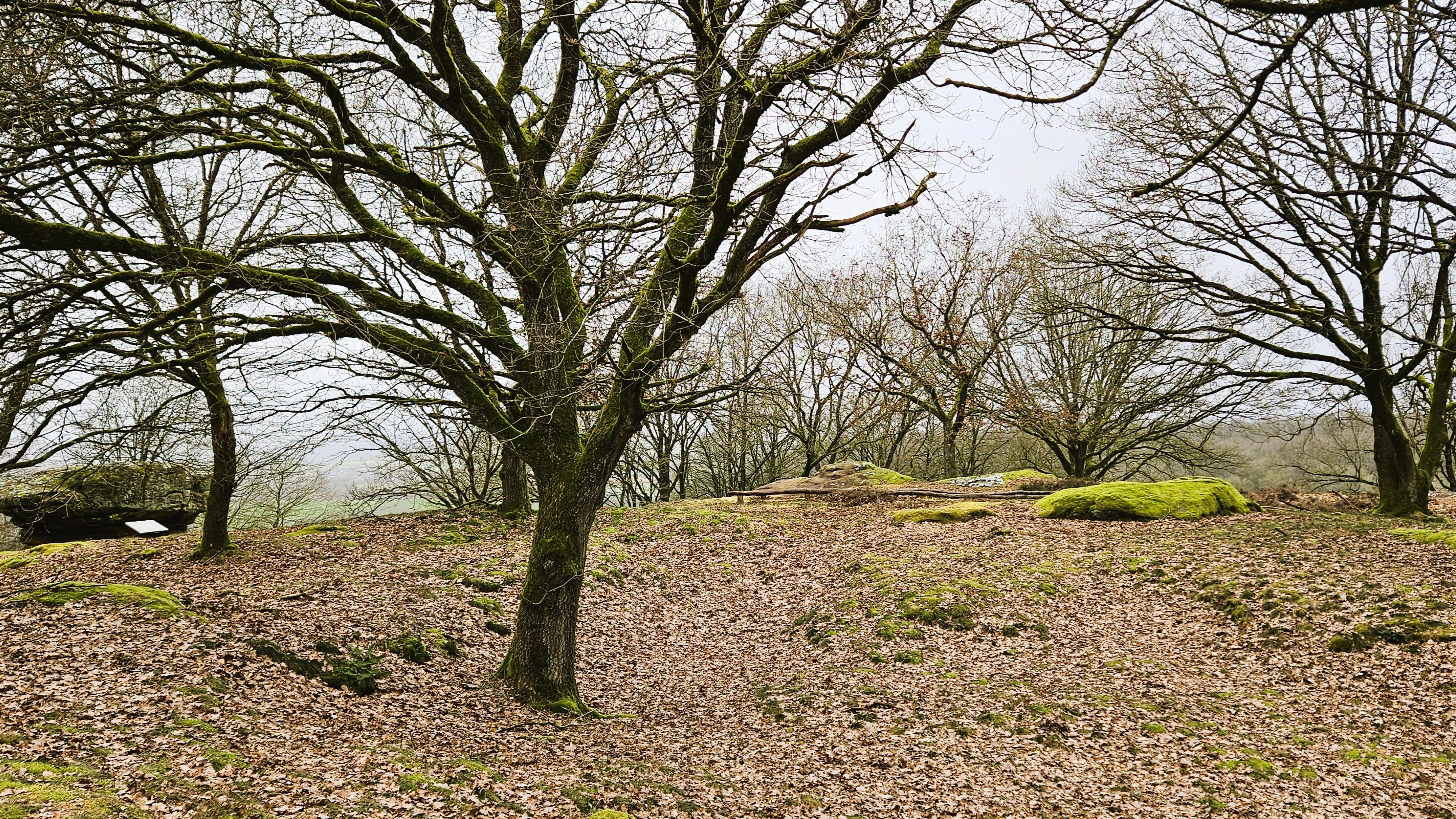
Eechelbuer-Lock landscape
Eechelbuer-Lock nature reserve, a special area of conservation with water and archaeological protection zones.

Eechelbuer-Lock wildlife and species highlights

While Eechelbuer-Lock is not primarily known as a wildlife destination, its mix of dry heath, juniper scrub, exposed sandstone, and adjacent forest edges provides habitat for species adapted to warm, open terrain in central Luxembourg. The semi-open character of the plateau, with patches of dense juniper interspersed with bare rock and short heath vegetation, is especially favorable for invertebrates typical of sandy and rocky environments, as well as for reptiles and ground-nesting birds that favor low, dry vegetation.

The placement of the Lock high above the surrounding Alzette valley and along ridges that connect to larger forested areas also makes the site a useful node in the wider ecological network of the Mellerdall Naturpark. Protected status as an FFH area in particular reflects the value of its dry, sandy habitats for fauna whose broader populations have declined across much of western Europe. For visitors, the wildlife experience at Eechelbuer-Lock is less about charismatic mammals and more about the quiet presence of heathland and juniper specialists whose survival depends on keeping this kind of small open landscape intact.
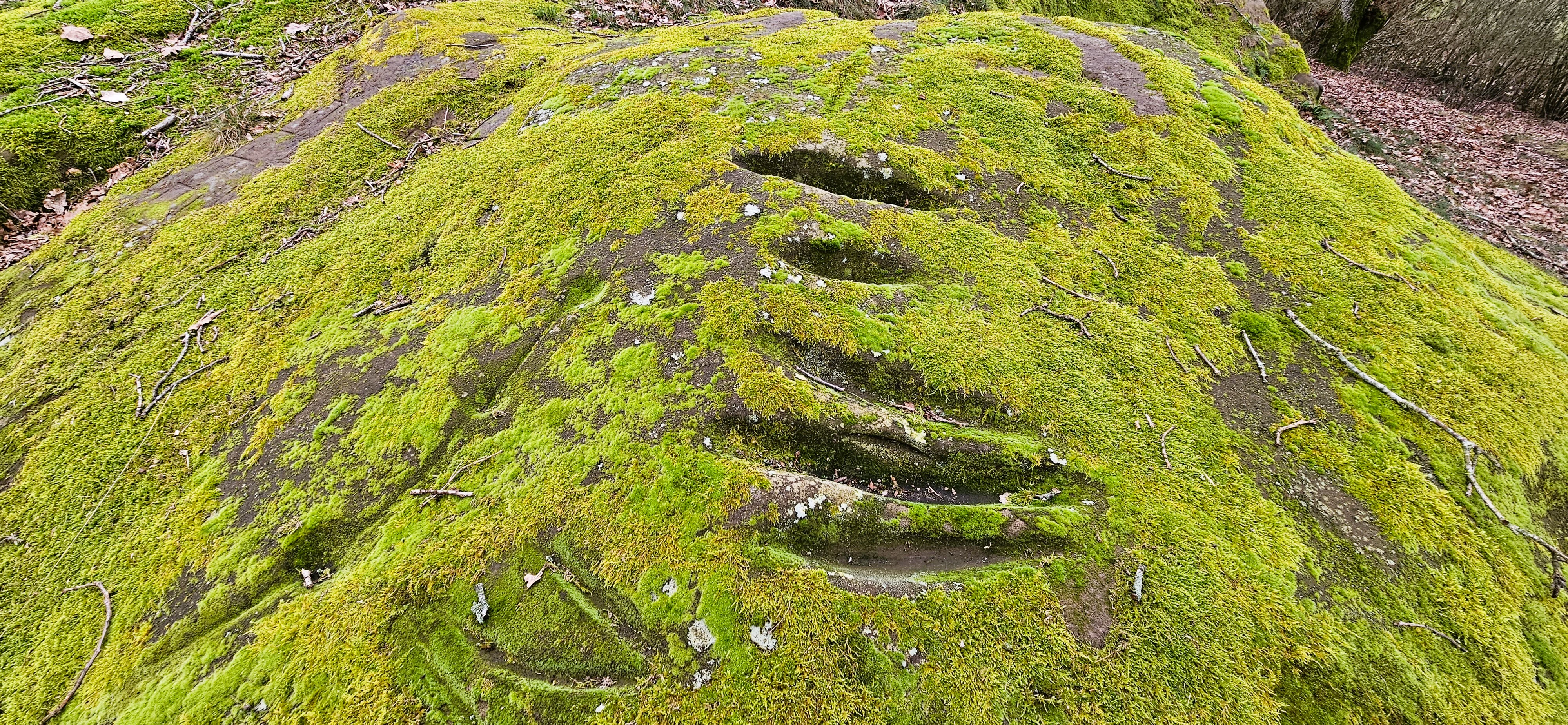
Eechelbuer-Lock nature reserve
A protected area in Nommern designated as a nature reserve, special area of conservation, water protection zone, and archaeological protection site.

Eechelbuer-Lock conservation status and protection priorities

Eechelbuer-Lock carries an unusually dense stack of conservation designations for its size. It is officially a Naturschutzgebitt (nature reserve), a Waasserschutzgebitt (water protection zone), a Fauna-Flora-Habitat area within the European Natura 2000 network, and a classified national monument. Together these protections address both biodiversity and hydrology, alongside the archaeological value of the plateau.

From a biodiversity perspective, the conservation focus is on maintaining the dry heath, juniper thickets, and open sandstone habitat mosaic that define the site. These habitats are characteristic of the Luxembourg Sandstone region but have become increasingly rare as open landscapes have either been abandoned to forest regrowth or converted to other uses. Protection as an FFH area places the Lock within the broader European effort to safeguard habitat types and species tied to dry, sandy, low-intensity environments.

The water protection designation reflects the importance of safeguarding infiltration and groundwater quality on the plateau, which feeds into the wider catchment feeding the Alzette valley and surrounding streams. Finally, the 1972 classification as a monument adds a cultural layer to the conservation regime, recognizing that rock engravings, ancient quarry traces, and the iconic Champignon rock are themselves part of why the area merits long-term protection.

Eechelbuer-Lock cultural meaning and human context

The cultural significance of Eechelbuer-Lock is inseparable from its natural setting. For at least ten millennia the plateau has provided a stage for human activity, including Mesolithic hunting camps, Bronze Age funerary practices associated with the urnfield tradition, Iron Age burial activity linked to the Laufeld and Honsrück-Eifel cultures, and later Roman-era quarrying. The continued physical traces of this long human presence; grinding grooves, cupules, quarry marks, and symbolic carvings on the sandstone; give the Lock a layered, almost palimpsest-like cultural landscape.

The naming of the site itself carries cultural history. "Lock" derives from an older Germanic and Celtic-rooted word for a pool or moist depression, and similar place names are widespread across Luxembourg's sandstone and marl regions, often marking places that once held water or retain some moisture today. The alternative name "Op de Leeën" continues that local folk tradition of geographic naming.

The site is also embedded in the broader cultural identity of the Mellerdall Naturpark, where sandstone landscapes, archaeological remains, and rural heritage have been developed into a coherent regional narrative around prehistoric settlement, stoneworking, and traditional land use. The systematic documentation of the engravings by Ernest Schneider in the early twentieth century helped establish Eechelbuer-Lock as a reference point in Luxembourg's archaeological scholarship.

Top sights and standout views in Eechelbuer-Lock

The single most distinctive feature of Eechelbuer-Lock is the mushroom-shaped "Champignon" sandstone boulder, a locally unique erosion formation whose exposed pedestal and heavy cap make it visually unmistakable. Around 40 additional sandstone blocks of varying sizes share the plateau with it, many carrying Mesolithic, Bronze Age, and Iron Age traces of human stoneworking.

A second highlight is the convergence of protections on one very compact site. Within a few hectares the Lock holds nature reserve, water protection, FFH, and monument status, allowing visitors to encounter an unusually rich combination of heathland, juniper scrub, prehistoric archaeology, and protected water resources in a single open landscape.

Finally, the long vistas over the Alzette valley toward Helperknapp, the framing forest edges, and the contrast between bare sandstone, juniper thickets, and dry heath vegetation give the plateau a strong visual identity that has remained broadly intact thanks to its long-standing legal protections.

Best time to visit Eechelbuer-Lock

Eechelbuer-Lock is a small, open sandstone plateau that is best appreciated in milder, drier weather when the heath vegetation is in active growth and the sandstone boulders are clearly visible. Spring and early summer tend to highlight the contrast between fresh juniper foliage, emerging heather, and bare rock, while late summer and early autumn often bring the most atmospheric conditions for viewing the characteristic mushroom-shaped Champignon rock and the wider plateau.

Because the site is a protected nature reserve and a classified monument, visitors should expect to walk around the perimeter and along designated paths rather than across the archaeological surface itself. Cool, low-wind days with good visibility are particularly rewarding because the open setting offers long views southwest over the Alzette valley and toward Helperknapp. In winter the heath and juniper take on a more austere character, and the sandstone shapes become even more prominent against the surrounding forest, although weather conditions can limit access and comfort.


Monthly climate preview

Long-term temperature and precipitation averages for Eechelbuer-Lock

Eechelbuer-Lock Climate Normals and Monthly Weather Patterns

Historical data compiled from NASA Power tracks the long-term temperature and precipitation rhythm across twelve recorded intervals at Eechelbuer-Lock. Analyzing these monthly baseline metrics provides a clearer picture of regional environmental trends before exploring the full climate profile.
Annual mean8 °C
0 °C18 °C
Jan
Feb
Mar
Apr
May12°
Jun15°
Jul18°
Aug17°
Sep13°
Oct
Nov
Dec
Warmest month
July

17.7 °C

Coolest month
January

-0.2 °C

Wettest month
December

2.9 mm/day

Driest month
April

1.7 mm/day

Park location guide

Geography guide, regional context, and park location map for Eechelbuer-Lock

Eechelbuer-Lock park geography, regions, and map view in Luxembourg

Understand where Eechelbuer-Lock sits in Luxembourg through a broader geographic reading of the surrounding landscape, nearby location context, and its mapped position within the national park landscape.

How Eechelbuer-Lock fits into Luxembourg

Luxembourg is a small landlocked nation in Western Europe and the world's only grand duchy. It borders Belgium, Germany, and France, with Luxembourg City as its capital and largest city. The country has one of the highest GDP per capita figures globally and hosts several EU institutions, notably the Court of Justice. Its population of nearly 700,000 is multinational, with Luxembourgish as the national language and French and German as administrative languages.

Wider geography shaping Eechelbuer-Lock in Luxembourg

Luxembourg is located in Western Europe, landlocked between Belgium to the west and north, Germany to the east, and France to the south. The terrain consists largely of forested uplands and plains in the Oesling region to the north, with the Gutland region in the south featuring more fertile land. The country covers 2,586 square kilometres, making it Europe's seventh-smallest nation.

Map view of Eechelbuer-Lock

Use this park location map to pinpoint Eechelbuer-Lock in Luxembourg, understand its exact geographic position, and read its mapped placement within the surrounding landscape more clearly.

Pigeon | © OpenStreetMap contributors

Location context for Eechelbuer-Lock

Noumer

Explore protected area scenery, geological formations, and unique habitat mosaics.

Eechelbuer-Lock Photos and Landscapes: Visualizing the Sandstone Plateau

Visual records illustrate the distinctive sandstone plateau, scattered boulders, and juniper heath vegetation defining Eechelbuer-Lock. Photographic documentation helps researchers examine terrain topography, erosion features, and protected habitats across the reserve.

Eechelbuer-Lock Mushroom rock formation

Eechelbuer-Lock nature reserve

Eechelbuer-Lock Nature Reserve

Eechelbuer-Lock landscape

Eechelbuer-Lock nature reserve

Park atlas

Compare nearby regional nature reserves, sandstone formations, and connected habitats

Explore Other Parks Near Eechelbuer-Lock and Surrounding Protected Landscapes

Browse protected areas adjacent to Eechelbuer-Lock to examine similar geological formations and regional terrain. Connecting across these neighboring reserves reveals broader patterns in central Luxembourg conservation geography.
Nature reserveLuxembourg
About 16 km away#1 closest

South

Cornelysmillen-Schucklai Nature Reserve: Geographic and Protected Area Overview

Wetland ecosystems on the Luxembourg plateau

Cornelysmillen-Schucklai serves as a key protected area of national interest, encompassing a mosaic of marshland, meadows, and deciduous woodland. This reserve acts as a vital corridor for moisture-dependent plant communities and threatened bird populations, defining the hydrological character of the plateau region with its intricate stream systems and restored pond basins.

Area
1.437 km²
Established
2023
Relief
Upland
Climate
Temperate
Nature reserveLuxembourg
About 16 km away#2 closest

South

Naturschutzgebitt Aarnescht Nature Reserve; Geographic Atlas and Protected Area Profile

Exploring calcareous dry grasslands and ecological mosaic habitats in Luxembourg

Discover the geographic composition of Naturschutzgebitt Aarnescht, a premier nature reserve in Luxembourg. This profile details the site's unique Keuper sediments, extensive orchid populations, and varied terrain, including traditional orchards and oak low-forests that form a vital protected landscape.

Area
0.752 km²
Established
1988
Relief
Upland
Climate
Temperate
Nature reserveLuxembourg
About 21 km away#3 closest

South

Naturschutzgebitt Birelergronn Nature Reserve: Luxembourg Protected Valley Geography

A sandstone valley landscape in central Luxembourg.

Naturschutzgebitt Birelergronn encompasses a 270 hectare nature reserve in Luxembourg, recognized for its complex hydrological features and historic milling valley structure. The area highlights the geological significance of the Luxembourg Sandstone, supporting diverse alluvial forests and the expansive Neimillen wetland complex which defines the regional ecosystem.

Area
2.717 km²
Established
1999
Relief
Upland
Climate
Temperate
Nature reserveLuxembourg
About 23 km away#4 closest

Southeast

Naturschutzgebitt Kelsbaach Nature Reserve: A Geographical Overview of Luxembourg Landscapes

Dolomite rock formations and protected dry grassland ecosystems

Naturschutzgebitt Kelsbaach preserves a distinctive environmental gradient across the Moselle valley hillsides in Luxembourg. From exposed dolomite cliffs and arid plateau grasslands to the shaded Kelsbaach stream gorge, the reserve illustrates the complex interplay of regional geology and microclimate. This protected area offers a precise look at local biodiversity habitats and the lasting impact of historical land use on the natural terrain.

Area
0.755 km²
Established
1998
Relief
Upland
Climate
Temperate
Nature reserveRheinland-Pfalz
About 26 km away#5 closest

Southeast

Langheck bei Nittel Nature Reserve: A Detailed Atlas of Protected Moselle Landscapes

Ecological geography and calcareous grassland habitat in Rheinland-Pfalz

Langheck bei Nittel is a significant nature reserve located in the Upper Moselle valley of Germany. The site protects a rare mosaic of calcareous dry grasslands, shrubbery, and forest edges that host a high concentration of orchid species. As a critical component of the regional biotope network, it offers insight into the conservation of warm-loving flora and the management of stony, nutrient-poor landscapes.

Area
0.42 km²
Established
1998
Nature reserveRheinland-Pfalz
About 27 km away#6 closest

Southeast

Perfeist bei Wasserliesch: Protected Grassland and Botanical Mapping in Rheinland-Pfalz

A regional sanctuary for rare orchids and calcareous meadow flora.

Perfeist bei Wasserliesch represents a significant protected area within the German Moselle landscape. Spanning 22 hectares of dry, sun-exposed calcareous soil on the Liescher Berg, the reserve offers a focused look at open grassland ecology. Its unique status as a botanical reference point highlights how small-scale protected land maintains rare plant species and fragile meadow habitats against the backdrop of the surrounding Moselle valley hill country.

Area
0.22 km²
Established
1986
Nature reserveLuxembourg
About 30 km away#7 closest

South

Beetebuerger Bësch: Nature Reserve and Protected Woodland Mapping in Luxembourg

A crucial reference site for forest ecology in southern Luxembourg

Beetebuerger Bësch stands as a designated nature reserve within the communes of Bettembourg, Leudelange, and Roeser. This protected forest landscape is managed to allow natural woodland development, providing researchers and visitors with a view of old growth dynamics, saproxylic invertebrate habitats, and restored riparian zones along the Koleschgriecht stream.

Area
2.373 km²
Established
2005
Relief
Lowland
Climate
Temperate
Protected landscapeProvince de Luxembourg
About 30 km away#8 closest

West

Parc naturel de la Vallée de l'Attert: Geography and Protected Landscape Analysis

Mapping the rural bocage and river corridors of southeastern Belgium

Understand the landscape composition of Parc naturel de la Vallée de l'Attert, a protected area bridging the Ardennes and Lorraine regions. This analysis covers the park's semi-bocage structure, alluvial river corridors, and the ecological transition defined by its unique regional geography.

Area
70.95 km²
Established
1994
Relief
Mixed relief
Climate
Temperate

Common questions about visiting, size, designation, and location context for Eechelbuer-Lock

Eechelbuer-Lock FAQs for park facts, access, geography, and protected area context

Find quick answers about Eechelbuer-Lock, including protected-area facts, park geography, trail and visitor context, and how the park fits into its surrounding country and regional landscape.
MoriAtlas Explorer

Continue Your Protected Areas Search Across the Global Atlas

Deepen your exploration by continuing the structured search for national parks and protected areas worldwide. Utilize the comprehensive filtering capabilities to compare different conservation landscapes and refine your understanding of global park geography. Discover more about the distribution and characteristics of protected natural areas.

Global natural geography
