

Mori Atlas logo
Marine protected areaEl Cachucho

Explore the complex deep sea geomorphology and protected offshore terrain of the Cantabrian Sea

El Cachucho Marine Protected Area: Mapping the Submarine Seamount Landscapes off Asturias

El Cachucho, also known as the Le Danois Bank, serves as a landmark marine protected area rising from the deep waters of the Bay of Biscay. This expansive submarine seamount stretches 57 kilometers off the Asturian coast, featuring deeply incised submarine canyons and diverse benthic habitats ranging from steep rocky outcrops to extensive sediment plains. Understanding this unique underwater geography provides essential insight into the offshore conservation landscapes defining the northern Iberian shelf.

marine protected areasubmarine seamountCantabrian SeaAsturiasdeep-sea habitatsubmarine canyons

El Cachucho

Marine protected area

Park overview

Structured park overview, official facts, and landscape profile for El Cachucho

El Cachucho park facts, protected area profile, and essential visitor context

Review the core facts for El Cachucho, including designation, size, terrain, visitor scale, habitats, and operating context in one park-focused overview.

About El Cachucho

El Cachucho is a prominent submarine seamount that defines part of the northern Spanish continental margin. Located in the Cantabrian Sea off Asturias, it sits within the broader context of one of the most geologically dynamic stretches of European Atlantic coastline. The Spanish northern shelf is unusually narrow, often only 20 to 40 kilometers wide, bordered by an abrupt continental slope marked by steep gradients of 10 to 12 percent. This narrow shelf gives way to a series of deeply cut submarine canyons, including the Avilés, Lastres, and Llanes canyons, which act as major sediment transfer pathways from the continent into deeper basins, especially during Quaternary glacial periods.

Onto this physically complex margin, the Le Danois Bank rises as an elongated east-west structure reaching from around 4,500 meters depth up to as little as 500 meters below sea level on its plateau. This vertical range, combined with varied substrate types, supports a wide variety of marine habitats. The area was investigated between 1934 and 1939 by French oceanographer Edouard Le Danois aboard the research vessel Président Théodore Tissier, who introduced the feature to the scientific community. Despite its biological richness and proximity to the Asturian coast, the bank remained poorly explored for decades.

The research group ECOMARG later identified the area as a priority for study, combining high productivity with exceptional biodiversity. This research directly informed the establishment of El Cachucho as a Site of Community Importance under the European Natura 2000 framework, a marine protected area dedicated to preserving deep-sea ecosystems in the southeastern Bay of Biscay. As Spain's first exclusively marine protected area, El Cachucho marked a shift from conservation frameworks that protected mainly coastal or partly marine territories, such as Doñana, the Cabrera Archipelago, and the Atlantic Islands of Galicia, toward a model that recognizes the ecological importance of offshore submarine landscapes.

Quick facts and research context for El Cachucho

El Cachucho, or the Le Danois Bank, is a submarine seamount in the Cantabrian Sea off Asturias. It was identified in the 1930s by French oceanographer Edouard Le Danois and is part of a narrow, steep Spanish continental margin bordered by canyons such as those of Avilés, Lastres, and Llanes. The bank itself extends approximately 57 km in length by 17 km in width, ascending from great depth to around 500 m at the shallowest parts of its plateau. Its designation marked Spain's first exclusively marine reserve, a Natura 2000 Site of Community Importance protecting deep-sea habitats and associated biodiversity.

Protection and recognition

Examine the documented marine protection scope and official designation records for El Cachucho.

El Cachucho Protection Status and Marine Protected Area Designation Records

Marine protection status records outline the regulatory scope and management framework established for El Cachucho. Structured conservation designations provide clear administrative context for this protected natural area.

Protection details

Protection scope
Marine
Transboundary protection
No
Park context

Deeper park guide and search-rich context for El Cachucho

El Cachucho history, landscape, wildlife, and travel context

Explore El Cachucho through its history, landscape character, ecosystems, wildlife, conservation priorities, cultural context, and seasonal travel timing in a structured park guide built for atlas discovery and search intent.

Why El Cachucho stands out

El Cachucho is best known for being Spain's first exclusively marine protected area, a designation that set a milestone for offshore conservation in the country. The seamount is celebrated for its complex geomorphology, including incised submarine canyons, rocky outcrops, sediment waves, and megaripples that shape distinct deep-sea habitats. Its biological richness, sustained by high primary productivity on the northern Iberian shelf, makes it a focal point for marine research and a recognized hotspot of deep-sea biodiversity in the southeastern Bay of Biscay.

El Cachucho history and protected-area timeline

The scientific history of El Cachucho began in the 1930s, when French oceanographer Edouard Le Danois conducted research cruises aboard the vessel Président Théodore Tissier between 1934 and 1939. His work revealed the existence of the bank that now bears his name, documenting its unusual character within the Cantabrian Sea.

For decades afterward, the feature remained largely unexplored, even though it lies within Spain's Exclusive Economic Zone only about 30 nautical miles from the coast of Asturias and sustains significant fishing activity. The ECOMARG research project, focused on the northern Iberian shelf, became a turning point by documenting the area's elevated biodiversity, geological complexity, and productivity. This growing understanding of the area's ecological value ultimately led to its designation as a Natura 2000 Site of Community Importance and Spain's first exclusively marine protected area, an institutional milestone in the broader development of Spanish marine conservation. The bank's geological origins are tied to compressive tectonic processes during the Paleogene, when imbricated thrust structures lifted the seafloor to form the present-day seamount.

El Cachucho landscape and geographic character

El Cachucho's landscape is entirely submarine, yet it reads like a mountain range hidden beneath the sea. The seamount rises out of the deep Bay of Biscay, climbing from roughly 4,500 meters depth toward shallower plateau areas of around 500 to 600 meters. The bank stretches about 57 kilometers in length and 17 kilometers in width along an elongated east-west axis, forming a distinctive escarpment within the Cantabrian Sea.

The surrounding continental margin amplifies the area's dramatic character. The northern Iberian shelf is unusually narrow, giving way to a steep continental slope incised by deeply carved submarine canyons. Notably, the Llanes and Lastres submarine canyons frame the central section of the studied platform, acting as the principal conduits that funnel sediment from the continent down into deep basins. The bank itself features four major geomorphological components: prominent rocky outcrops with strong relief, alternating hard lithologies, massive rocky outcrops, lower-relief rocky areas with thin sediment cover, and a range of sediment forms, including flat unconsolidated sedimentary floors, sediment waves, and sand ridges. Together, these varied substrates create a richly textured seafloor that contrasts sharply with the deeper, flatter abyssal areas nearby.

El Cachucho ecosystems, habitats, and plant life

El Cachucho hosts an unusually diverse set of marine ecosystems for an offshore environment. The combination of a narrow but productive continental shelf, steep slopes, incised canyons, and an elevated seamount creates a mosaic of habitats. Hard substrates, including prominent rocky outcrops and massive rocky areas, support communities adapted to strong currents, while lower-relief rocky zones with thin sediment cover offer different ecological niches. Together with megaripples, sand ridges, and unconsolidated sedimentary plains, the seamount supports a varied benthic environment.

The high primary productivity of the northern Iberian shelf feeds into the food web on and around the bank, sustaining a complex biological community. Le Danois Bank acts as both a refuge and a meeting point for species from deeper and shallower environments, contributing to its strong biodiversity signal. This productivity and habitat heterogeneity made the area a natural candidate for marine protection as part of the Natura 2000 ecological network.

El Cachucho wildlife and species highlights

El Cachucho is recognized for its rich fauna, including communities typical of both deep and intermediate waters of the southeastern Bay of Biscay. The seamount's elevated plateau and surrounding slopes host diverse benthic and demersal species groups, supported by the high biological productivity driven by the narrow but productive northern Iberian shelf. The bank has long been associated with commercial fisheries, including traditional Asturian fishing grounds referenced locally as the caladero El Cachuchu.

Research efforts by the ECOMARG project have documented the area's elevated biodiversity relative to surrounding seafloor, with species assemblages shaped by rocky outcrops, canyon walls, and sediment plains. These varied habitats create conditions where cold-water corals, deep-sea invertebrates, and demersal fish species can coexist across relatively small spatial scales.

El Cachucho conservation status and protection priorities

El Cachucho's designation as a Site of Community Importance under the European Natura 2000 framework established a new chapter in Spanish marine conservation, marking the first time Spain created a protected area focused exclusively on marine territory, rather than coastal or partially marine reserves like Doñana, Cabrera, or the Atlantic Islands of Galicia. This designation recognized the seamount's ecological importance, its role as a reservoir of biodiversity, and the need to safeguard deep-sea habitats from pressures including commercial fishing.

The conservation framework protects a complex set of benthic habitats, including rocky outcrops of varying relief, sediment-dominated areas, megaripple fields, and canyon geomorphologies. By safeguarding these features, El Cachucho contributes to the long-term preservation of biodiversity in the southeastern Bay of Biscay and provides a reference point for future offshore marine protection efforts in Spain and across Europe.

El Cachucho cultural meaning and human context

El Cachucho carries a strong regional identity among Asturian fishing communities, where it has long been known by the local name caladero El Cachuchu, referring to a productive fishing ground. The feature's formal scientific name, however, reflects the legacy of French oceanographer Edouard Le Danois, who introduced it to the broader scientific community through research cruises in the 1930s. This dual naming captures the area's identity as both a local working fishery and an internationally recognized deep-sea ecosystem of European conservation importance.

Top sights and standout views in El Cachucho

El Cachucho stands out as Spain's first exclusively marine protected area, an institutional milestone for offshore conservation in the country. Its elongated, east-west submarine seamount shape, combined with deeply incised canyons such as Lastres and Llanes, defines one of the most distinctive seafloor landscapes of the Cantabrian Sea margin. The protected area safeguards a varied suite of deep-sea habitats, from rocky outcrops with strong relief to megaripple fields and sediment plains, sustaining high biodiversity driven by the productivity of the northern Iberian shelf.

Best time to visit El Cachucho

El Cachucho is a fully submerged marine protected area located about 30 nautical miles off the Asturian coast, and is not a typical visitor destination. Seasonal conditions of the Cantabrian Sea influence the character of any offshore activity in the area, with calmer summer months generally offering more workable conditions for research cruises and marine excursions, while the rougher winter sea state reflects the energetic Atlantic weather patterns that shape this stretch of coastline year-round.
Monthly climate preview

Long-term representative coordinate records for temperature and precipitation patterns in Asturias

El Cachucho Climate Normals and Measured Annual Temperature Rhythm

El Cachucho exhibits a measured annual temperature range alongside distinct monthly precipitation variations across the representative coordinate. Reviewing the complete twelve-month climatology data provides deeper insight into long-term averages for this protected area.
Annual mean15 °C
12 °C20 °C
Jan12°
Feb12°
Mar12°
Apr13°
May15°
Jun17°
Jul19°
Aug20°
Sep19°
Oct17°
Nov15°
Dec13°
Warmest month
August

20.2 °C

Coolest month
February

11.6 °C

Wettest month
November

4.9 mm/day

Driest month
July

0.9 mm/day

Park location guide

Geography guide, regional context, and park location map for El Cachucho

El Cachucho park geography, regions, and map view in Spain

Understand where El Cachucho sits in Spain through a broader geographic reading of the surrounding landscape, nearby location context, and its mapped position within the national park landscape.

How El Cachucho fits into Spain

Spain, officially the Kingdom of Spain, is a unitary parliamentary constitutional monarchy located in Southern and Western Europe. The country occupies most of the Iberian Peninsula and includes territories in the Mediterranean and Atlantic. With a population of approximately 49.6 million and an area of 506,030 km², Spain is a major European economy and cultural force. Its capital is Madrid, and the country is known for its diverse landscapes ranging from mountainous regions to coastal areas.

Wider geography shaping El Cachucho in Spain

Spain occupies the Iberian Peninsula in Southern and Western Europe. Peninsular Spain is bordered to the north by France, Andorra, and the Bay of Biscay; to the east and south by the Mediterranean Sea and Gibraltar; and to the west by Portugal and the Atlantic Ocean. The territory includes the Canary Islands in the Atlantic Ocean, the Balearic Islands in the Mediterranean Sea, and the autonomous cities of Ceuta and Melilla in mainland Africa. Spain features diverse terrain including the Pyrenees in the northeast, the Sierra Nevada in the south, and the Meseta Central plateau.

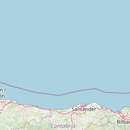
Map view of El Cachucho

Use this park location map to pinpoint El Cachucho in Spain, understand its exact geographic position, and read its mapped placement within the surrounding landscape more clearly.

Pigeon | © OpenStreetMap contributors

Location context for El Cachucho

Asturias
Recorded earthquake history

Examine the El Cachucho Earthquake History and Seismic Records

Gain insight into the seismic history of the El Cachucho marine protected area by reviewing this collection of recorded earthquake data. MoriAtlas presents these historical events to support geographic exploration of the Cantabrian Sea seafloor and its surrounding tectonic context.

El Cachucho Earthquake History

Catalogued events

3 events

Strongest magnitude

Magnitude 3.7

Most recent event

Apr 25, 1995

This history includes earthquakes recorded inside the park or within 50 km of its borders

Park atlas

Compare surrounding regional habitats and adjacent conservation zones

Explore Parks Near El Cachucho and Related Protected Marine Landscapes

Continue browsing other protected areas near El Cachucho to examine similar submarine geology and regional marine reserves. Discovering adjacent marine habitats provides broader geographical context for the Cantabrian Sea and northern Iberian shelf.
Watercolor illustration of a mountain landscape with green forests and a body of water.
National parkSpain
63 km away#1 closest

South

Picos de Europa National Park: Dramatic Limestone Peaks and Protected Landscape Atlas

Explore Spain's historic national park and UNESCO Biosphere Reserve.

Picos de Europa National Park offers an unparalleled exploration of dramatic limestone peaks, deep glacial valleys, and extensive Atlantic forests. As Spain's oldest national park and a UNESCO Biosphere Reserve, it presents a remarkable study in karst landscape evolution and biodiversity conservation. This protected area, spanning significant territory across northern Spain, provides a rich geographic context for understanding regional natural heritage and mapped natural features.

Area
671.27 km²
Established
1918
IUCN
II
Relief
Mountain
Biosphere reserveBasque Country
143 km away#2 closest

Southeast

Reserva de la biosfera de Urdaibai: Protected Coastal and Estuarine Geographic Atlas

Mapping wetlands, forests, and cliffs in the Basque Country

Explore the complex terrain of Reserva de la biosfera de Urdaibai, spanning the tidal Oka estuary to the peaks of Mount Oiz. This protected landscape is defined by its vast saltmarshes, Cantabrian oak forests, and dramatic coastal cliffs that anchor the natural geography of the Basque Country.

Area
224.52 km²
Established
1984
Relief
Mixed relief
Climate
Temperate
Biosphere reserveProvincia de León
148 km away#3 closest

Southwest

Reserva de la biosfera de los Ancares Leoneses: Protected Mountain Terrain and Atlas

Mapping the Sierra de Ancares river valleys in Provincia de León

Examine the geographic layout and protected boundaries of the Reserva de la biosfera de los Ancares Leoneses. This biosphere reserve serves as a critical mountain corridor, featuring complex river basins and diverse forest cover that highlight the region's environmental and cultural history across the Spanish highlands.

Area
567.86 km²
Established
2006
Relief
Mountain
Scope
Terrestrial
Biosphere reserveLugo
160 km away#4 closest

Southwest

Reserva de la Biosfera de Los Ancares Lucenses y Montes de Cervantes, Navia y Becerreá Protected Area Map

Mountainous terrain and river valley geography in Lugo, Spain

This protected area covers the dramatic Sierra de Ancares, featuring steep mountain slopes and deep river valleys that define the geography of Galicia. The reserve spans a significant vertical relief, providing essential habitats for brown bears and capercaillie while preserving traditional rural mountain land use systems and ancient forest ecosystems.

Area
536.64 km²
Established
2006
Relief
Mountain
Climate
Temperate
Biosphere reserveGalicia
167 km away#5 closest

Southwest

Reserva de la biosfera de las Tierras del Miño: Mapped Landscapes and Geographic Overview

Extensive riverine forests and wetland networks in northwestern Spain

Explore the expansive territory of Reserva de la biosfera de las Tierras del Miño, spanning a large portion of the Galician interior. This protected area features a mosaic of wetlands, riparian corridors, and mountainous terrain, offering a deep look into the ecological and cultural geography of the upper Miño river basin.

Area
3,636.69 km²
Established
2002
Relief
Lowland
Scope
Terrestrial
Protected landscapeCastilla y León
207 km away#6 closest

Southeast

Sabinares del Arlanza-La Yecla: A Detailed Protected Landscape and Map of Burgos

Ancient juniper woodlands and deep limestone ravines in Castilla y León.

This protected area centers on the remarkable juniper forests and the narrow, vertical walls of the La Yecla gorge. The landscape serves as an essential habitat for cliff-nesting raptors while bridging the terrain between the Sierra de la Demanda foothills and the Arlanza River basin. The map captures the geological diversity of these limestone structures and the expansive botanical value found within this significant Spanish natural entity.

Area
391.74 km²
Established
2020
IUCN
V
Relief
Upland
Biosphere reserveGalicia
218 km away#7 closest

West

Reserva de la biosfera de las Mariñas Coruñesas y Tierras del Mandeo: Regional Geography and Maps

A diverse protected area across Galicia, Spain

This biosphere reserve serves as a vital ecological refuge along the Cantabrian-Atlantic coast. The protected area features a unique mosaic of marine and terrestrial habitats, ranging from rocky coastal cliffs and sandy estuaries to dense Atlantic forest fragments and the mountainous interior of the Sierra de la Cova da Serpe.

Area
1,139.7 km²
Established
2013
Relief
Mixed relief
Climate
Temperate
Biosphere reserveLa Rioja
235 km away#8 closest

Southeast

Valles del Jubera, Leza, Cidacos y Alhama: Protected Landscapes in La Rioja, Spain

A biosphere reserve featuring limestone gorges and dinosaur fossil sites

Valles del Jubera, Leza, Cidacos y Alhama forms a distinct mid-mountain region in northern Spain where four river valleys have carved deep passages into the earth. The area serves as a vital protected landscape containing rich paleontological history, thermal springs, and traditional Mediterranean forests. This atlas entry details the natural boundaries and geographic character of one of Spain's significant biosphere reserves.

Area
1,196.69 km²
Established
2003

Common questions about visiting, size, designation, and location context for El Cachucho

El Cachucho FAQs for park facts, access, geography, and protected area context

Find quick answers about El Cachucho, including protected-area facts, park geography, trail and visitor context, and how the park fits into its surrounding country and regional landscape.
MoriAtlas Explorer

Continue Your Protected Areas Search Across the Global Atlas

Deepen your exploration by continuing the structured search for national parks and protected areas worldwide. Utilize the comprehensive filtering capabilities to compare different conservation landscapes and refine your understanding of global park geography. Discover more about the distribution and characteristics of protected natural areas.

Global natural geography