
Mori Atlas logo
Nature reserveElbinseln Pillnitz und Gauernitz

Examining the ecological integrity and floodplain geography of these historic river fragments

Elbinseln Pillnitz und Gauernitz: Rare Protected River Islands of the Saxon Elbe Valley

(Naturschutzgebiet Elbinseln Pillnitz und Gauernitz)

Elbinseln Pillnitz und Gauernitz safeguards a rare remnant of the original Upper Elbe landscape in Germany. Representing the last two natural river islands in Saxony, this nature reserve protects a critical complex of floodplain soils, unarmored riverbanks, and riparian forests that remain essential for regional ecological connectivity. This protected area stands as a vital node for diverse riverine habitats within the broader Saxon Elbe valley corridor.

nature reservefloodplainriver islandsUpper Elberiparian forestsoftwood alluvial forest
A flat-style digital illustration depicting a calm river winding through a valley with willow and deciduous trees, rolling hills with pine forests in the background, and distant mountains featuring a waterfall.

Elbinseln Pillnitz und Gauernitz

Nature reserve

Park overview

Structured park overview, official facts, and landscape profile for Elbinseln Pillnitz und Gauernitz

Elbinseln Pillnitz und Gauernitz park facts, protected area profile, and essential visitor context

Review the core facts for Elbinseln Pillnitz und Gauernitz, including designation, size, terrain, visitor scale, habitats, and operating context in one park-focused overview.

About Elbinseln Pillnitz und Gauernitz

Elbinseln Pillnitz und Gauernitz is a compact but ecologically meaningful nature reserve on the Upper Elbe in Saxony. Although small in area (about 23.5 hectares), it protects a landscape element that has become extraordinarily rare in this region: natural river islands still shaped by the dynamic processes of a major Central European river.

The reserve sits within the broader Elbe Valley landscape between Dresden and Meißen, a corridor of immense ecological and cultural importance. Centuries of navigation improvements, flood protection, and nineteenth century channelization transformed the once braided, island-rich Upper Elbe into a heavily regulated shipping channel. Although that engineering brought economic benefits, it removed most of the islands, side arms, and gravel habitats that had defined the river. Today, only a handful of fragments survive.

The Pillnitzer Elbinsel, near the famous Pillnitz palace complex on the eastern outskirts of Dresden, and the Gauernitzer Elbinsel, further downstream near the municipality of Gauernitz, are the two surviving Saxon islands of the Upper Elbe. They still carry the imprint of natural river dynamics: floodplain soils, soft alluvial forests, naturally eroding banks, and shallow aquatic zones along the margins. Together they form a small, coherent refuge for floodplain biodiversity in an otherwise heavily modified river landscape.

The site's importance is reinforced by its integration into European-level protection networks. It contributes to the larger FFH site "Elbtal zwischen Schöna und Mühlberg" and the corresponding European Birds Directive Special Protection Area, both of which span a long stretch of the Saxon Elbe Valley. This connects the small reserve to broader conservation ambitions for the Elbe as a transnational river ecosystem.

Quick facts and research context for Elbinseln Pillnitz und Gauernitz

Elbinseln Pillnitz und Gauernitz is a state-level nature reserve (Naturschutzgebiet) in Saxony, Germany, classified as an IUCN Category IV habitat and species management area. It lies in the Elbe Valley between Dresden and Meißen, near the localities of Pillnitz and Gauernitz, and encompasses the Pillnitzer Elbinsel and the Gauernitzer Elbinsel.

The reserve is administered under German nature reserve identifier D 35 and is recorded in the World Database on Protected Areas under WDPA ID 165003. It sits within the FFH site "Elbtal zwischen Schöna und Mühlberg" and the European Birds Directive site of the same name, linking it to transnational Elbe floodplain protection efforts.

Protection and recognition

Documented terrestrial protection scope, designation records, and administrative framework

Elbinseln Pillnitz und Gauernitz Protection Status and International Recognition

Elbinseln Pillnitz und Gauernitz maintains a recorded terrestrial protection scope within the global protected areas database. Official records outline the baseline conservation status and designated management parameters without additional international recognition sources.

Protection details

Protection scope
Terrestrial
Transboundary protection
No
WDPA ID
165003
Park context

Deeper park guide and search-rich context for Elbinseln Pillnitz und Gauernitz

Elbinseln Pillnitz und Gauernitz history, landscape, wildlife, and travel context

Explore Elbinseln Pillnitz und Gauernitz through its history, landscape character, ecosystems, wildlife, conservation priorities, cultural context, and seasonal travel timing in a structured park guide built for atlas discovery and search intent.

Why Elbinseln Pillnitz und Gauernitz stands out

The reserve is best known for preserving the last surviving Saxon river islands of the Upper Elbe. After the major nineteenth century straightening and regulation of the Elbe, nearly all natural islands along this stretch were lost, making these two fragments rare survivors of a once widespread landscape type. It is equally recognized for the intact floodplain habitats they still support, including softwood alluvial forests, hardwood oak-elm-ash floodplain forests, and naturally formed riverbanks with shallow water zones. These conditions provide essential refuge for mammals such as the Eurasian beaver and European otter, for rare fish like asp and white-finned gudgeon, for saproxylic beetles, and for a notable assemblage of breeding and resting birds along the Elbe corridor.
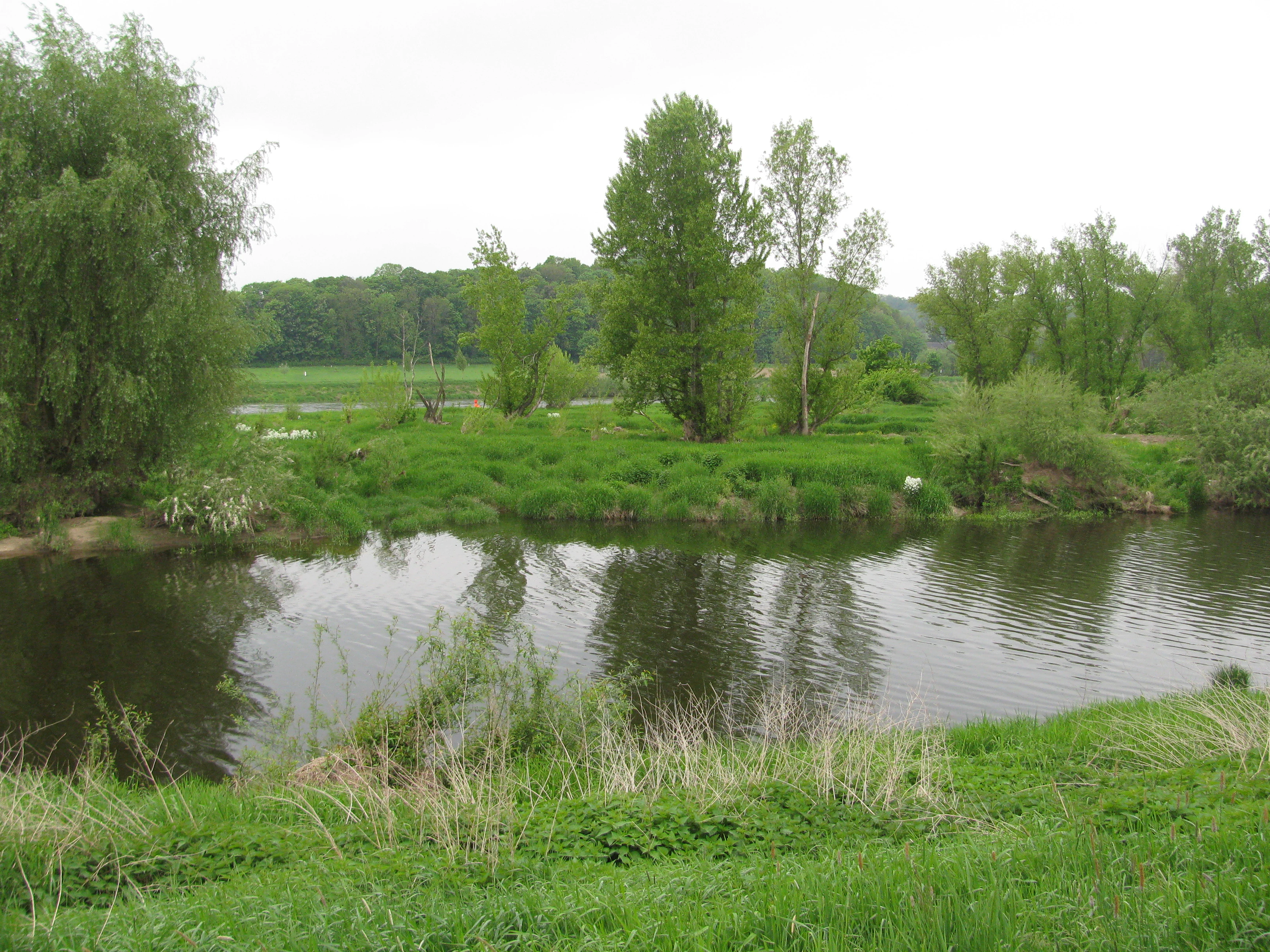
A peaceful view of the green Gauernitz Elbe island in Germany, featuring a river in the foreground, grassy banks, and deciduous trees under an overcast sky.
A view of the Gauernitz Elbe island, showing the lush floodplain vegetation and riparian environment.

Elbinseln Pillnitz und Gauernitz history and protected-area timeline

The Elbinseln Pillnitz und Gauernitz were not originally designated as a protected area; their protected status is a response to the dramatic loss of natural island habitat along the Upper Elbe over the past two centuries. Major nineteenth century engineering works straightened the Elbe, narrowed its channel, and destroyed most of its islands, side arms, and shallow banks. By the early twenty first century, only the Pillnitzer Elbinsel and the Gauernitzer Elbinsel remained as natural islands in the Saxon stretch of the Upper Elbe.

Recognizing the rarity and ecological value of these remaining fragments, the Regierungspräsidium Dresden (Dresden Regional Authority) formally designated the area as a nature reserve (Naturschutzgebiet) by ordinance dated 4 January 2006, published in the Sächsisches Amtsblatt on page 121. The reserve was assigned the official NSG identifier D 35 and entered into the World Database on Protected Areas as record 165003. Since then, the islands have been managed specifically to preserve their remaining floodplain character, native habitat types, and associated species communities, rather than allowing further loss through riverbank hardening, vegetation change, or disturbance.

Elbinseln Pillnitz und Gauernitz landscape and geographic character

The landscape of the reserve is the landscape of a small, low-lying river island: flat, shaped by floods, and edged by gently sloping banks. Both islands lie within the floodplain of the Elbe, sitting on characteristic alluvial soils (Auenböden) that have been deposited and reworked by the river over long periods. The terrain retains a discernible natural relief, which is one of the explicit reasons for its protection.

The shoreline of the islands is a defining feature of the reserve. Unlike much of the regulated Upper Elbe, where banks have been reinforced and armored, these islands are required to maintain a high proportion of natural, unarmored shoreline and shallow water zones. These soft transitions between land and water are central to the reserve's value, supporting both aquatic and terrestrial species and preserving the dynamic character of the river margin.

Surrounding the reserve, the wider Elbe Valley between Dresden and Meißen provides the dramatic context of Saxon river scenery: gentle floodplain meadows, agricultural land on the higher terraces, and the wooded slopes that frame the valley. The Pillnitzer Elbinsel sits within the broader landscape of the Dresdner Elbwiesen (Dresden Elbe Meadows) and old river arms, while the Gauernitzer Elbinsel lies in the Elbe Valley landscape between Dresden and Meißen, with views toward the Spaar hills (Spaargebirge). Although the islands themselves are small, they form a distinctive feature within this larger scenic corridor.

Elbinseln Pillnitz und Gauernitz ecosystems, habitats, and plant life

Ecologically, the reserve represents an exceptionally rare surviving sample of Upper Elbe floodplain habitat. Its protected habitats directly reflect the floodplain character of the site and align with habitat types recognized under the European Habitats Directive (FFH). These include alder and ash floodplain forests, softwood alluvial forests (Weichholzauwälder), and oak-elm-ash hardwood floodplain forests (Eichen-Ulmen-Eschen-Auenwälder), all of which depend on regular river dynamics and on soils that retain floodwater and sediment.

Beyond the closed woodland, the reserve protects more open and transitional habitats that are typical of natural river margins. These include moist tall-herb communities (feuchte Hochstaudenfluren) and pioneer vegetation on muddy riverbanks (einjährige Pioniervegetation schlammiger Flussufer). These early-successional habitats are particularly important because they are routinely lost when riverbanks are stabilized; the reserve's explicit aim to keep large sections of shoreline unarmored is what makes this rare habitat type persist here.

The mosaic of woodland, soft bank, shallow water, and floodplain soil creates a compact but diverse ecological unit. This mosaic sustains a wide range of species: aquatic and semi-aquatic fauna along the bank's edge, forest species in the alluvial woodlands, and open-country or wetland species in the more open habitats. The reserve is therefore ecologically rich out of all proportion to its small size, because it still contains the structural diversity that the rest of the Upper Elbe has largely lost.

Elbinseln Pillnitz und Gauernitz wildlife and species highlights

The wildlife interest of Elbinseln Pillnitz und Gauernitz reflects the reserve's combination of intact floodplain forest, soft banks, and shallow water. Among the most distinctive mammals are the Eurasian beaver (Biber) and the European otter (Fischotter), both of which depend strongly on natural, unarmaged riverbanks and quiet floodplain waters, which are exactly the conditions the reserve is designed to maintain. Several bat species also use the islands and the surrounding floodplain woodland.

The aquatic fauna is another highlight. The reserve supports rare or sensitive fish species such as the asp (Rapfen), the white-finned gudgeon (Weißflossen-Gründling), and Atlantic salmon (Lachs), all of which rely on diverse riverbank structures and intact side habitats. Invertebrate specialists are also present, including the hermit beetle (Eremit), a saproxylic species associated with old trees in floodplain woodland, and two dragonflies of conservation concern: the green emerald (Grüne Keiljungfer) and the Asian emerald (Asiatische Keiljungfer).

The birds of the reserve are especially significant. The islands and their banks provide breeding habitat, resting habitat, and refuges for disturbance-sensitive species, including the lake frog (Seefrosch) area's waterbirds and a range of water-associated and riparian birds such as grey heron (Graureiher), goosander (Gänsesäger), smew (Zwergsäger), osprey (Fischadler), honey buzzard (Wespenbussard), common sandpiper (Flussuferläufer), black woodpecker (Schwarzspecht), common kingfisher (Eisvogel), and rook (Saatkrähe). The protection of breeding, roosting, and resting sites on these small islands gives the reserve an outsized role in supporting birdlife along the Saxon Upper Elbe.

Elbinseln Pillnitz und Gauernitz conservation status and protection priorities

Conservation significance at Elbinseln Pillnitz und Gauernitz rests on the fact that the site preserves an almost vanished landscape type. The Upper Elbe has lost most of its natural islands and soft banks due to nineteenth and twentieth century river regulation, and these two surviving fragments are effectively irreplaceable. Their protection has therefore been framed explicitly around rarity and ecological distinctiveness, not just local habitat value.

The reserve is classified as an IUCN Category IV habitat and species management area, reflecting its objective of actively maintaining particular habitats and species populations. Its conservation goals are unusually concrete for a small site: preserve the islands' natural relief, retain their original floodplain soils, keep a high share of unarmored shoreline and shallow water, and maintain the habitat types listed under the EU Habitats Directive that still occur here. These include softwood and hardwood alluvial forests, moist tall-herb communities, and pioneer vegetation on muddy banks.

A central conservation value is the protection of breeding, roosting, and resting habitat for endangered or disturbance-sensitive species, ranging from otters and beavers to rare dragonflies, saproxylic beetles, and water-associated birds. By embedding the reserve into larger European networks (the FFH site "Elbtal zwischen Schöna und Mühlberg" and the corresponding Birds Directive Special Protection Area), Saxon authorities have ensured that the small site functions as a node within a much longer, transnational conservation corridor for the Elbe floodplain.

Elbinseln Pillnitz und Gauernitz cultural meaning and human context

The reserve sits in a corridor of deep cultural as well as natural significance. The nearby village of Pillnitz is famous for its baroque palace complex, where Chinese, Japanese, and Old-Holland-inspired garden elements were developed in the eighteenth century. The Pillnitzer Elbinsel is the last natural river island that still belongs, in administrative and landscape terms, to the immediate surroundings of this historically important Saxon royal residence.

Downstream, the Gauernitzer Elbinsel lies in a stretch of the Elbe Valley that links Dresden with the wine and porcelain town of Meißen, one of Saxony's oldest cultural centers. The Elbe Valley between the two cities has long been a defining cultural landscape of the region, valued both as a setting for centuries of courtly, monastic, and later industrial activity, and as one of the key vistas of traditional Saxon scenery. By protecting the rare surviving islands within this famous valley, the reserve preserves not only biodiversity but also a tangible reminder of how the river used to shape both ecosystem and cultural identity in this part of Saxony.

Top sights and standout views in Elbinseln Pillnitz und Gauernitz

Elbinseln Pillnitz und Gauernitz concentrates several distinctive qualities into a very small area. Its two surviving floodplain islands are the last natural Elbe islands in Saxony, a direct legacy of the river's unaltered dynamics.

The reserve's other defining quality is habitat integrity: natural alluvial soils, soft unarmored banks, softwood and hardwood floodplain forests, and pioneer vegetation on muddy shores all still occur here. These conditions support an unusually broad species list for the area, including beaver, otter, rare fish, dragonflies, saproxylic beetles, and a notable suite of waterbirds. Finally, the site's embedding within the larger FFH and Birds Directive Elbe Valley protection zones gives this modest reserve a much wider conservation footprint along the Saxon Upper Elbe.

Best time to visit Elbinseln Pillnitz und Gauernitz

Seasonal timing is less about operational access, which is not detailed in the source material, and more about the character of the Elbe Valley and the natural dynamics of a floodplain reserve. Spring is the period when river levels rise and flood-meadow and riverbank communities are most active, while also being a key time for breeding amphibians, dragonflies, and water-associated birds across the islands.

Summer brings the densest vegetation and the warmest conditions for observing woodland edge and riverbank life, including insects and many of the dragonfly and bird species for which the reserve is noted. Autumn and winter, with leaves gone and water levels often lower, can be particularly favorable for spotting beaver and otter activity along the soft banks, and for observing waterbirds using the islands as quiet resting and roosting sites, which is one of the explicit protection goals of the reserve.

Monthly climate preview

Long-term representative temperature and precipitation patterns across the year

Elbinseln Pillnitz und Gauernitz Climate Normals and Weather by Month

Representative coordinates record measured monthly temperature swings alongside steady precipitation variations from 1991 through 2020. Examining the complete twelve-month climatology profile reveals broader environmental trends across the protected landscape.
Annual mean8 °C
-2 °C19 °C
Jan-2°
Feb-1°
Mar
Apr
May13°
Jun17°
Jul19°
Aug19°
Sep14°
Oct
Nov
Dec-1°
Warmest month
July

19.1 °C

Coolest month
January

-1.8 °C

Wettest month
July

2.8 mm/day

Driest month
April

1.3 mm/day

Park location guide

Geography guide, regional context, and park location map for Elbinseln Pillnitz und Gauernitz

Elbinseln Pillnitz und Gauernitz park geography, regions, and map view in Germany

Understand where Elbinseln Pillnitz und Gauernitz sits in Germany through a broader geographic reading of the surrounding landscape, nearby location context, and its mapped position within the national park landscape.

How Elbinseln Pillnitz und Gauernitz fits into Germany

Germany is a federal republic in Western and Central Europe with a population of over 83 million across sixteen constituent states. It is Europe's largest economy by nominal GDP and a major global exporter and importer. The capital is Berlin, and the country borders Denmark, Poland, Czech Republic, Austria, Switzerland, France, Luxembourg, Belgium, and the Netherlands.

Wider geography shaping Elbinseln Pillnitz und Gauernitz in Germany

Germany is located in Western and Central Europe, spanning 357,022 km². It borders Denmark to the north, Poland and the Czech Republic to the east, Austria and Switzerland to the south, and France, Luxembourg, Belgium, and the Netherlands to the west. The country has coastlines on the Baltic Sea and North Sea to the north, with the Alps located in the southern region.

Map view of Elbinseln Pillnitz und Gauernitz

Use this park location map to pinpoint Elbinseln Pillnitz und Gauernitz in Germany, understand its exact geographic position, and read its mapped placement within the surrounding landscape more clearly.

Pigeon | © OpenStreetMap contributors

Visual reference guide to rare Elbe floodplain terrain and riparian habitats

Elbinseln Pillnitz und Gauernitz Photos and Protected River Island Scenery

Elbinseln Pillnitz und Gauernitz photos capture the rare remaining river islands and unarmored shorelines of the Upper Elbe Valley. Visual documentation reveals the distinct alluvial soils, riparian woodland structure, and floodplain habitats preserved across the Saxon nature reserve.

A peaceful view of the green Gauernitz Elbe island in Germany, featuring a river in the foreground, grassy banks, and deciduous trees under an overcast sky.

Park atlas

Compare nearby Saxon river corridors, floodplain reserves, and protected natural areas.

Other Parks Near Elbinseln Pillnitz und Gauernitz and Connected Regional Protected Landscapes

Browsing other parks near Elbinseln Pillnitz und Gauernitz reveals connected river habitats and regional floodplain conservation zones along the Upper Elbe. Expanding the geographic scope allows travelers to compare similar riparian landscapes and protected natural areas throughout Saxony.
Watercolor painting of a soft landscape featuring distant hills and foreground vegetation in shades of green, yellow, and soft red.
Nature reserveSachsen
About 1 km away#1 closest

Northeast

Dresdner Elbtalhänge Nature Reserve: Geography, Mapped Boundaries, and Landscape Context

An essential nature reserve along the Elbe valley in Sachsen

Dresdner Elbtalhänge captures the striking transition between the flat Elbe floodplain and the Westlausitz hill region. This detailed atlas entry covers the reserve's unique geomorphology, including its incised ravine systems, south-facing oak forests, and exposed rock formations that define its protected character within Sachsen.

Area
203.6 km²
Established
2007
IUCN
IV
A watercolor illustration depicting rolling, soft hills and green vegetation with distant, faded mountains in the background, set against a plain white background.
Nature reserveGermany
About 6.1 km away#2 closest

South

Spargründe bei Dohna: Nature Reserve and Protected Valley Landscapes in Germany

Examining the crystalline ravines and forest ecosystems of the Saxon landscape

Spargründe bei Dohna stands as a distinct nature reserve at the northern margin of the Elbtalschiefergebirge. The site encompasses narrow, steeply-sided valleys carved into Dohna Granodiorite, creating a rugged terrain of rocky ridges and shaded deciduous woodland. This geographic overview examines the boundaries and natural features of the reserve, highlighting its role within the wider Müglitztal protected area network.

Area
0.373 km²
Relief
Upland
Climate
Temperate
Access
Easy access
Watercolor painting showing a landscape with green hills, trees, and a river winding through the scene
National parkGermany
About 11 km away#3 closest

East

Saxon Switzerland National Park: Protected Area Geography and Map Exploration

Discover its mapped boundaries and regional landscape context.

Saxon Switzerland National Park, a protected national park in Germany, offers a distinct focus for geographic and atlas-based discovery. This page details the park's specific protected landscape, its mapped boundaries, and its contribution to the regional geography. MoriAtlas allows for in-depth exploration of such natural areas, providing essential context for understanding their place within broader natural systems and mapped terrains.

Area
93.5 km²
Established
1990
IUCN
II
Visitors
1.7M annual
Nature reserveFreistaat Sachsen
About 15 km away#4 closest

West

Windberg Nature Reserve: Mapping the Forested Ridge and Protected Landscape of Saxony

Geology, mining heritage, and protected oak-beech forest ecosystems

Windberg serves as the prominent local landmark for Freital, defined by its elongated forested plateau and complex tectonic geography. This nature reserve offers a study in the intersection of environmental conservation and human industrial history, featuring Saxony's deepest cave and varied habitats within the eastern Ore Mountains foothills.

Established
1967
Relief
Mountain
Climate
Temperate
Access
Easy access
A pale, soft watercolor painting depicting a small arched bridge crossing a gentle stream within a rolling green valley.
Protected landscapeSaxony
About 16 km away#5 closest

North

Seifersdorfer Tal Protected Landscape and Cultural Heritage in Saxony

A historic garden monument and river valley ecosystem

The Seifersdorfer Tal is a protected landscape defining the Große Röder valley. Beyond its cultural status as one of Germany's earliest English-style landscape gardens, the area serves as a vital riverine corridor and nature reserve. The terrain offers a unique blend of rocky outcrops, wooded slopes, and meadows linked by historic footpaths and 18th-century allegorical monuments.

Area
2.88 km²
Established
1960
Relief
Upland
Climate
Temperate
A horizontal watercolor illustration showing a calm pond in the foreground, with lush green vegetation on the banks and rolling hills in the background under a soft sky.
Nature reserveMeißen
About 21 km away#6 closest

Northwest

Dippelsdorfer Teich Nature Reserve: Geographic Insights and Landscape Context

Historic Saxon pond management and regional protected landscape.

The Dippelsdorfer Teich serves as a primary example of historical pond construction and nature protection in the northern Dresden countryside. This 69 hectare reservoir captures a blend of ecological, cultural, and recreational values within the Meißen region. Users can examine its physical layout, the dam structure, and the integration of heritage transport within this managed lowland environment.

Area
0.69 km²
Established
1528
Relief
Lowland
Scope
Terrestrial
Nature reserveSaxony
About 22 km away#7 closest

West

Weißeritztalhänge Nature Reserve: Protected Slope Forests and River Valley Geography

Regional landscape profile in Saxony, Germany

Weißeritztalhänge represents a significant nature reserve situated along the Wilde Weißeritz in Saxony. The protected area features expansive slope forests that transition from the Saxon lowlands into the Erzgebirge, providing a critical refuge for diverse woodland and river-dwelling species.

Area
4.486 km²
Established
1961
IUCN
IV
Relief
Upland
Nature reserveSächsische Schweiz-Osterzgebirge
About 23 km away#8 closest

South

Weicholdswald Nature Reserve: Mapped Protected Landscapes of the Eastern Ore Mountains

A preserved beech forest enclave within the Sächsische Schweiz-Osterzgebirge

Weicholdswald stands as a primary nature reserve in the Sächsische Schweiz-Osterzgebirge district, known for its 160-year-old beech trees and extensive deadwood habitats. This protected area provides a rare look at near-natural forest ecosystems that have remained free from historic clear-cutting or coniferous monocultures, maintaining rich biodiversity across its streams and granitic slopes.

Area
1.037 km²
Established
1961
IUCN
IV

Common questions about visiting, size, designation, and location context for Elbinseln Pillnitz und Gauernitz

Elbinseln Pillnitz und Gauernitz FAQs for park facts, access, geography, and protected area context

Find quick answers about Elbinseln Pillnitz und Gauernitz, including protected-area facts, park geography, trail and visitor context, and how the park fits into its surrounding country and regional landscape.
MoriAtlas Explorer

Continue Your Protected Areas Search Across the Global Atlas

Deepen your exploration by continuing the structured search for national parks and protected areas worldwide. Utilize the comprehensive filtering capabilities to compare different conservation landscapes and refine your understanding of global park geography. Discover more about the distribution and characteristics of protected natural areas.

Global natural geography