
Mori Atlas logo
Protected landscapeElmendorfer Holz

A study of near-natural lowland forest communities and protected landscape boundaries in Ammerland

Elmendorfer Holz: Mapping the Ecological Landscape and Protected Woodland in Niedersachsen

Elmendorfer Holz stands as a compact, ecologically dense woodland located in the municipality of Bad Zwischenahn within the Niedersachsen region of Germany. This protected landscape represents an important, intact stand of mixed deciduous forest dominated by aged oaks and hornbeams. The area serves as a significant reference site for forest ecology, featuring distinct transitions between beech, oak, and alder-ash swamp forest communities on a remarkably small geographic footprint.

lowland forestoak-hornbeam woodlandbeech woodlanddeciduous forestFFH sitehabitats directive
A vibrant, flat-style digital illustration featuring a tall granite mountain cliff with a waterfall, a meandering river in the foreground, and pine trees under a sunset-toned sky.

Elmendorfer Holz

Protected landscape

Park overview

Structured park overview, official facts, and landscape profile for Elmendorfer Holz

Elmendorfer Holz park facts, protected area profile, and essential visitor context

Review the core facts for Elmendorfer Holz, including designation, size, terrain, visitor scale, habitats, and operating context in one park-focused overview.

About Elmendorfer Holz

Elmendorfer Holz sits in the gently undulating lowlands of the Ammerland, a district in the northwest of Lower Saxony characterized by a patchwork of pasture, heath remnants, woodland fragments, and scattered villages. The forest lies just north of the Zwischenahner Meer, the third-largest lake in Lower Saxony and a focal point of regional tourism.

Despite its modest size, the woodland displays a remarkable degree of ecological variation. The dominant forest type is a semi-natural oak and hornbeam association on moist sites, with local transitions into acidic beech woodland enriched by holly. Oaks dominate the canopy, and a substantial share of these trees are more than one hundred years old, giving the forest a distinctly ancient, irregular structure very different from the regimented conifer stands common elsewhere in the region. Small patches of alder-ash woodland occupy the wettest micro-sites.

The herb layer reflects this habitat mosaic. On drier, more acidic ground it features wood anemone-like indicators of beechwood communities, while the moister oak-hornbeam stands carry species such as wood stitchwort, yellow archangel, and giant horsetail associates. The combination of old growth structure, varied soil moisture, and long continuity of broadleaf cover is what gives Elmendorfer Holz its conservation significance.

At a broader scale, the forest forms part of the Ammerland's network of protected woodland fragments, many of which are relics of former estate or commons forests. Although private ownership continues in places, the dominant present-day identity of Elmendorfer Holz is shaped by the overlapping protection frameworks applied to it, which together aim to preserve its near-natural character and allow continued natural dynamics within a defined natural forest reserve zone.

Quick facts and research context for Elmendorfer Holz

Elmendorfer Holz is a roughly 28 hectare mixed deciduous forest in Bad Zwischenahn, Lower Saxony, within the Ammerland district. It lies north of the Zwischenahner Meer at elevations between about 7 and 12 meters above sea level.

The area carries two overlapping designations: a Lower Saxony landscape protection area (Landschaftsschutzgebiet) under the identifier LSG WST 093, and an EU Habitats Directive site covering almost the same footprint. A western section of about 12 hectares was additionally designated as a natural forest reserve (Naturwald) in 2017.

Protection and recognition

Examining official Natura 2000 listings and documented conservation boundaries

Elmendorfer Holz Protection Status and International Recognition Data

Elmendorfer Holz maintains formal documentation regarding protected area status and Natura 2000 designation records. Structured records track international recognition sources, management scope, and conservation boundaries for this protected area.
Park context

Deeper park guide and search-rich context for Elmendorfer Holz

Elmendorfer Holz history, landscape, wildlife, and travel context

Explore Elmendorfer Holz through its history, landscape character, ecosystems, wildlife, conservation priorities, cultural context, and seasonal travel timing in a structured park guide built for atlas discovery and search intent.

Why Elmendorfer Holz stands out

Elmendorfer Holz is best known as a compact example of near-natural oak and hornbeam mixed forest on moist lowland soils in northwestern Germany. Many of its oaks are well over a century old, and the woodland shows unusually clear transitions between oak-hornbeam forest, acidic beech woodland with holly, and small patches of alder-ash swamp forest. It is also recognized for the density of protective designations layered onto a small area, combining landscape protection, Habitats Directive recognition, and a dedicated natural forest reserve. This stacking of statuses, rather than its size, makes it a notable reference site for forest ecology in the Ammerland region.
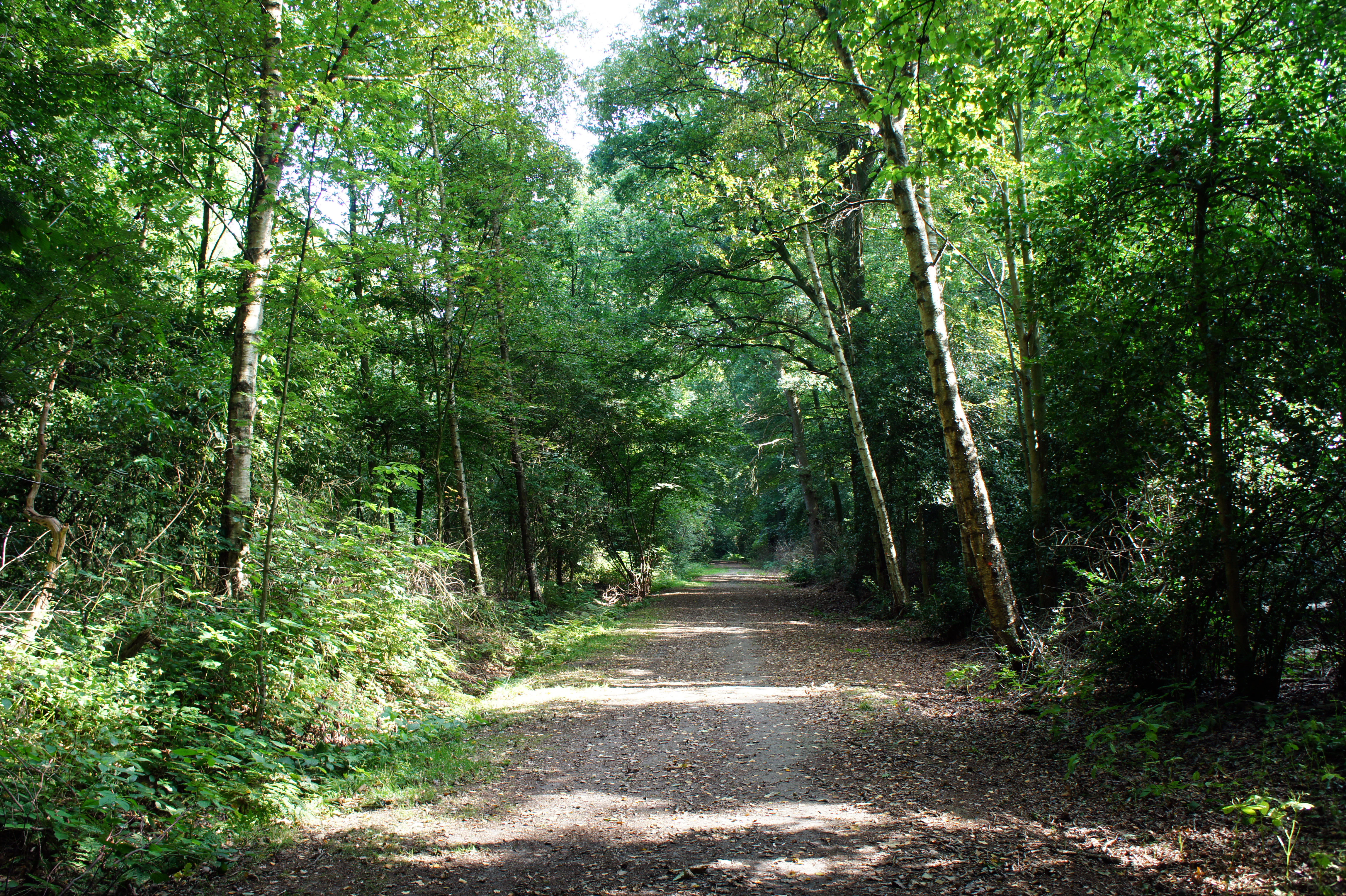
A wide dirt walking path leading into a dense, green deciduous forest with sunlight filtering through the canopy.
A shaded forest path through the Elmendorfer Holz protected area.

Elmendorfer Holz history and protected-area timeline

The Elmendorfer Holz, also historically referred to as the Herrenholz, belongs to a category of old estate and common woodlands typical of the Ammerland region, where fragments of former noble or communal forests have survived amid later agricultural and settlement expansion.

Its modern conservation history began with its designation as a landscape protection area (Landschaftsschutzgebiet), registering the site as LSG WST 093, which secured the broader landscape context of the woodland. This was followed by recognition of most of the forest as an EU Habitats Directive site, aligning it with the broader Natura 2000 network for habitat and species protection across Europe.

In 2017, about 12 hectares in the western part of the woodland were additionally set aside as a Naturwald, or natural forest reserve. Under this status, non-native tree species have been progressively removed, and forestry interventions have been minimized so that natural processes such as regeneration, aging, and local dieback can shape the stand over time. The step consolidated the role of Elmendorfer Holz as a reference site for near-natural forest dynamics in Lower Saxony's northwestern lowlands.

Elmendorfer Holz landscape and geographic character

The landscape of Elmendorfer Holz is that of the northwestern German lowlands, with very gentle relief and elevations that climb only modestly above the surrounding farmland. Within the forest itself, ground levels vary from about 7 meters to about 12 meters above sea level, producing subtle but ecologically meaningful differences in soil moisture and forest community across short distances.

The woodland sits on the northern shore of the Zwischenahner Meer, a sizeable shallow lake that defines much of the regional scenery and recreation. Away from the lake edge, the surrounding Ammerland landscape is a mosaic of improved pasture, drained mardorf-style farmland, scattered hedgerows, and small villages, with the forest standing out as a denser, darker green patch within an otherwise open cultural landscape.

Within the forest, the terrain is essentially flat but quietly varied. Slight depressions hold moister oak-hornbeam with alder-ash influences, while slightly higher and better-drained ground carries more acidic beechwood character. There are no cliffs, rock outcrops, or dramatic landforms; the visual interest is created instead by canopy structure, the age of the dominant oaks, and the shift between community types across very short distances.

Elmendorfer Holz ecosystems, habitats, and plant life

Ecologically, Elmendorfer Holz is significant for the way it concentrates multiple forest habitat types into a small area. The principal community is oak-hornbeam woodland on moist mineral soils, a traditional Central European lowland forest type now greatly reduced across much of northern Germany. This grades into more acidic beech woodland carrying holly in the understory, and in the wettest places gives way to small patches of alder-ash forest.

The unusually diverse herb layer reflects these transitions. Drier units include wintergreen indicators typical of beechwoods, while the moist oak-hornbeam stands host species such as wood avens, enchanter's nightshade, herb Paris, and sedges and rushes associated with damp woodland soils. Some areas also carry butterbur-like or creeping Jenny associates typical of wet woodland margins.

The overall ecological value lies less in rarity at the national scale and more in the integrity and continuity of the habitat complex at the local scale. The forest has retained old-growth structure, native species composition, and natural regeneration patterns, offering a living baseline for what lowland broadleaf forest in the Ammerland would have looked like before modern forestry simplified the landscape.

Elmendorfer Holz wildlife and species highlights

The wildlife profile of Elmendorfer Holz is that of a mature, structurally diverse deciduous lowland forest in an agricultural landscape. The combination of old oaks with cavities and deadwood, dense understory in places, and proximity to wetland margins around the nearby Zwischenahner Meer supports a rich community of forest birds, small mammals, and woodland invertebrates.

Thewoodland's Habitats Directive status reflects its value for groups such as forest-dwelling bats, woodlandbreeding birds, and the specialist invertebrate and fungal assemblages associated with old broadleaf trees. Deadwood and veteran oaks are particularly important structural features, providing nesting and roosting sites as well as substrate for saproxylic species.

At the local landscape scale, the forest functions as a refuge and dispersal hub within a largely cultivated matrix, allowing woodland-dependent species to persist in the Ammerland even as open farmland dominates the wider area. Visitors typically encounter common woodland birds, signs of deer and small mammals, and a broad seasonal range of insects and fungi in summer and autumn.

Elmendorfer Holz conservation status and protection priorities

Elmendorfer Holz is unusual in that three different protective frameworks converge on essentially the same small area. As a Landschaftsschutzgebiet, it is protected for its broader landscape and recreational value. As an EU Habitats Directive site, it is recognized for the presence of protected habitat types, with oak-hornbeam woodland among the priority features.

The 2017 designation of about 12 hectares in the western portion as a Naturwald reserves added a process-oriented layer of protection. In this natural forest zone, management is limited to the removal of non-native tree species, after which natural dynamics such as regeneration, competition, and local mortality are allowed to proceed with minimal intervention.

Together these layers make the forest a small but high-value reference site for conservation of lowland deciduous forest in northwestern Germany, both for habitat preservation and for demonstration of how natural forest processes can be allowed back into heavily human-shaped landscapes.

Elmendorfer Holz cultural meaning and human context

The name Herrenholz, used alongside the modern designation Elmendorfer Holz, hints at the site's older role as part of an estate or noble forest, a category of woodland common in the Ammerland region and elsewhere in northwestern Germany. Many small forests here trace their origins to medieval or early modern tenure systems in which certain woodlands were reserved as Herrenholz for the local lord or as commons for community use.

In the present day, the forest's cultural role is closely tied to recreation around the Zwischenahner Meer. Bad Zwischenahn has historically attracted visitors drawn to the lake and its curative associations, and Elmendorfer Holz functions as a quiet wooded counterpoint to the busier lakeshore. Marked paths through the woodland invite short walks and link it informally into the wider tourism landscape of the Ammerland, while the protection of the forest as landscape and habitat preserves a sense of continuity with the older local tradition of valuing these small woods as communal amenities.

Top sights and standout views in Elmendorfer Holz

Elmendorfer Holz is a compact but ecologically dense forest reserve, layered with landscape protection, Habitats Directive, and natural forest designations. Its old oak canopy, transitions between several forest community types within a short distance, and natural forest reserve zone make it a strong local reference site for near-natural lowland broadleaf forest.

Its setting just north of the Zwischenahner Meer gives it a dual identity: ecologically it is a quiet refuge for woodland habitats in an agricultural landscape; culturally and recreationally it is part of the walking and nature experience that complements visits to the lake.

Best time to visit Elmendorfer Holz

The forest can be visited comfortably through much of the year. Spring brings fresh leaf-out on the oaks and hornbeams and the most active display of the woodland herb layer, including the early-flowering species on moist sites, making it a rewarding time for botanical interest.

Summer offers deep shade and a quiet walking experience, with the lake nearby adding an obvious destination afterwards. Autumn is particularly good for those interested in fungi and the visual character of the older oaks, while winter, though less colorful, reveals the underlying structure of the stand: the irregular crowns of veteran oaks, the transitions between forest types, and the network of paths through the protected area.


Monthly climate preview

Long-term representative temperature and precipitation averages for Niedersachsen

Elmendorfer Holz Climate Normals and Measured Weather by Month

Elmendorfer Holz exhibits a documented annual temperature rhythm ranging from winter minimums below freezing to warm summer maximums alongside consistent daily precipitation. Reviewing the complete monthly climate normals reveals detailed temperature averages and precipitation patterns recorded across the representative coordinate.
Annual mean9 °C
1 °C18 °C
Jan
Feb
Mar
Apr
May13°
Jun16°
Jul18°
Aug18°
Sep14°
Oct10°
Nov
Dec
Warmest month
July

17.9 °C

Coolest month
January

1.2 °C

Wettest month
July

2.5 mm/day

Driest month
April

1.4 mm/day

Park location guide

Geography guide, regional context, and park location map for Elmendorfer Holz

Elmendorfer Holz park geography, regions, and map view in Germany

Understand where Elmendorfer Holz sits in Germany through a broader geographic reading of the surrounding landscape, nearby location context, and its mapped position within the national park landscape.

How Elmendorfer Holz fits into Germany

Germany is a federal republic in Western and Central Europe with a population of over 83 million across sixteen constituent states. It is Europe's largest economy by nominal GDP and a major global exporter and importer. The capital is Berlin, and the country borders Denmark, Poland, Czech Republic, Austria, Switzerland, France, Luxembourg, Belgium, and the Netherlands.

Wider geography shaping Elmendorfer Holz in Germany

Germany is located in Western and Central Europe, spanning 357,022 km². It borders Denmark to the north, Poland and the Czech Republic to the east, Austria and Switzerland to the south, and France, Luxembourg, Belgium, and the Netherlands to the west. The country has coastlines on the Baltic Sea and North Sea to the north, with the Alps located in the southern region.

Map view of Elmendorfer Holz

Use this park location map to pinpoint Elmendorfer Holz in Germany, understand its exact geographic position, and read its mapped placement within the surrounding landscape more clearly.

Pigeon | © OpenStreetMap contributors

Location context for Elmendorfer Holz

Landkreis AmmerlandNiedersachsen
Recorded earthquake history

Review Recorded Historical Earthquakes near Elmendorfer Holz

Access a curated catalogue of seismic activity associated with the Elmendorfer Holz landscape. This collection facilitates geographic discovery by providing event details and proximity data for recorded earthquakes within the broader Ammerland region, helping observers understand historical seismic patterns.

Elmendorfer Holz Earthquake History

Catalogued events

1 event

Strongest magnitude

Magnitude 3

Most recent event

Jul 2, 2006

This history includes earthquakes recorded inside the park or within 50 km of its borders

Explore woodland scenery, old oak habitats, and protected lowland terrain features.

Elmendorfer Holz Photos and Landscapes: Visual Guide to the Protected Forest

Examine detailed Elmendorfer Holz photos to understand the intricate canopy structure and moist deciduous habitats of this protected German forest reserve. Visual records reveal the subtle terrain shifts and ancient oak stands that define the character of the surrounding Ammerland landscape.

A wide dirt walking path leading into a dense, green deciduous forest with sunlight filtering through the canopy.

Park atlas

Compare regional woodland reserves and lowland protected landscapes across Ammerland

Explore Other Parks and Protected Areas Near Elmendorfer Holz

Continue geographic comparison by examining other protected areas near Elmendorfer Holz and the surrounding lowland terrain. Expanding the scope allows visitors to analyze related forest reserves and regional woodland ecosystems within northwestern Germany.
Nature reserveAmmerland
About 20 km away#1 closest

West

Vreschen-Bokel am Aper Tief: Protected Nature Reserve and River Wetland Geography

Mapping the lowland meadows and tidal channels of Ammerland, Germany.

Vreschen-Bokel am Aper Tief protects a complex landscape of species-rich meadows and ancient river channels of the Aper Tief. Situated in the flat terrain of the Ammerland district, this reserve provides a vital glimpse into the hydrological character of the northwestern German coastal region and its ongoing ecological restoration.

Area
1.044 km²
Established
2009
IUCN
IV
Relief
Lowland
Watercolor painting showing coastal wetlands with mudflats, salt marshes, and distant hills under a soft light
National parkLower Saxony
23 km away#2 closest

Northwest

Lower Saxon Wadden Sea National Park: Protected Coastal Landscape & Geography Atlas

Explore mapped boundaries, intertidal zones, and Lower Saxony's natural terrain.

Delve into the Lower Saxon Wadden Sea National Park, a significant national park situated in Lower Saxony, Germany. This page serves as your atlas entry point for understanding its protected landscape, characterized by vast mudflats, salt marshes, and a crucial role as a migratory bird corridor. Discover the geographic context of this UNESCO World Heritage site and its unique intertidal ecosystem through structured map data and detailed landscape information.

Area
345.8 km²
Established
1986
IUCN
II
Relief
Lowland
Protected landscapeNiedersachsen
24 km away#3 closest

Northeast

Dornebbe, Braker Sieltief und Colmarer Tief: Mapped Protected Landscape in Niedersachsen

Geographic atlas of tidal lowland waterways and coastal habitats

Dornebbe, Braker Sieltief und Colmarer Tief comprises a chain of slow-flowing streams and bank habitats essential to the coastal marshland geography of Niedersachsen. The area provides a structured look at multi-layered habitat protection, featuring dense reedbeds and aquatic corridors vital for regional biodiversity in the German tidal zone.

Area
0.33 km²
Established
2018
Nature reserveOldenburg
27 km away#4 closest

Southeast

Tannersand und Gierenberg Nature Reserve: Inland Dunes and Bog Pool Mapping

Protected sandy geest landscape within the Osenberge near Oldenburg

Tannersand und Gierenberg represents a vital nature reserve featuring an unusual inland dune system and embedded wetland Slatts. The protected area exhibits a dense contrast between coniferous dune ridges and peat-moss-rich swamps. This record details the park boundaries, landscape mosaic, and the specific terrain that classifies it as a significant protected site within Lower Saxony, Germany.

Area
0.35 km²
Established
1938
Nature reserveLandkreis Cloppenburg
About 33 km away#5 closest

South

Talsperre Thülsfeld Nature Reserve: Geography and Protected Land Profile

Inland dune and wetland conservation in Landkreis Cloppenburg

Talsperre Thülsfeld functions as a protected nature reserve showcasing the traditional northwest German lowland landscape. The site contains a five kilometer long reservoir, expansive heathlands, and bog communities, offering a clear view of how glacial geography shapes modern conservation areas. Researchers and observers can examine the transition between dry sandy dunes and damp riverine floodplains within this concentrated ecological boundary.

Area
4.62 km²
Established
1957
Relief
Lowland
Climate
Temperate
A horizontal watercolor painting depicting a soft-focus landscape with a pond in the foreground, pink and green heath vegetation, and distant tree lines under a pale sky.
Nature reserveBremen
About 34 km away#6 closest

East

Eispohl, Sandwehen und Heideweiher: Protected Landscape and Geest Geography

Nature reserve featuring historic dunes and heath pond networks

This nature reserve in Bremen protects a remnant of the Rekumer Geest, featuring a complex of inland dunes, wet heath, and small heath ponds. Through its combination of extensively grazed grasslands and mixed forests, the area serves as a vital habitat corridor, maintaining the traditional Geest landscape patterns that once dominated the region between Bremen and the lower Weser.

Area
0.036 km²
Established
1988
Relief
Lowland
Climate
Temperate
Nature reserveLower Saxony
About 35 km away#7 closest

Northeast

Strohauser Vorländer und Plate Nature Reserve: Geography and Protected Area Atlas

Tidal wetlands and freshwater habitats in Lower Saxony

The Strohauser Vorländer und Plate nature reserve protects a expansive tidal floodplain characterized by its river island geography, slow-moving side arms, and seasonal inundation patterns. As a focal point for meadow-bird monitoring, this site offers a clear view into the ecological dynamics of the Lower Weser river landscape, showcasing a rare combination of summer-dike-protected meadows and open freshwater tidal flats.

Area
11.52 km²
Established
2007
IUCN
IV
Nature reserveOldenburg
37 km away#8 closest

Southeast

Stühe Nature Reserve: A Detailed Map and Geographic Overview of the Delmenhorster Geest

Protected beech forests and lowland bog ecosystems in Oldenburg

Stühe serves as a significant forest refuge in the Oldenburg district, showcasing a rare intersection of beech, oak, and riparian floodplain forests. This nature reserve, anchored within the wider Delmenhorster Geest landscape, features glacial depressions, kettle-like stillwaters, and preserved bog monuments that document the natural history of the northwest German lowlands.

Area
2.17 km²
Established
2018
Relief
Lowland
Climate
Temperate

Common questions about visiting, size, designation, and location context for Elmendorfer Holz

Elmendorfer Holz FAQs for park facts, access, geography, and protected area context

Find quick answers about Elmendorfer Holz, including protected-area facts, park geography, trail and visitor context, and how the park fits into its surrounding country and regional landscape.
MoriAtlas Explorer

Continue Your Protected Areas Search Across the Global Atlas

Deepen your exploration by continuing the structured search for national parks and protected areas worldwide. Utilize the comprehensive filtering capabilities to compare different conservation landscapes and refine your understanding of global park geography. Discover more about the distribution and characteristics of protected natural areas.

Global natural geography