Mori Atlas logo
State or regional parkEmory Creek Provincial Park

Mapping the historical crossroads and river valley terrain of a former nineteenth century boomtown site

Emory Creek Provincial Park: Protected Riverside Landscapes and Fraser Canyon Geography

Emory Creek Provincial Park serves as a protected geographic landmark in British Columbia, situated along the storied banks of the Fraser River. This site offers a unique perspective on the Fraser Canyon, where rugged river terrain meets the remnants of an expansive nineteenth century boomtown that once supported gold mining and major railway infrastructure. Through mapped boundaries and river valley context, this location provides a clear window into the intersection of natural riparian landscapes and industrial frontier history in western Canada.

Fraser RiverFraser Canyonhistoric sitegold rush historyCanadian Pacific RailwayBritish Columbia

Emory Creek Provincial Park

State or regional park

Park overview

Structured park overview, official facts, and landscape profile for Emory Creek Provincial Park

Emory Creek Provincial Park park facts, protected area profile, and essential visitor context

Review the core facts for Emory Creek Provincial Park, including designation, size, terrain, visitor scale, habitats, and operating context in one park-focused overview.

About Emory Creek Provincial Park

Emory Creek Provincial Park lies along the west side of the Fraser River in the Fraser Valley Regional District of British Columbia, just south of the small community of Yale. The park is a compact provincial protected area administered by BC Parks and classified under IUCN Category II. Although it is modest in size, the park occupies a stretch of riverside land that carries considerable cultural and historical weight in the regional story of British Columbia.

The park's significance is rooted in the dramatic expansion and decline of a nineteenth-century settlement that once stood at or near the present park area. Emory Creek began in 1858 as a rough tent and shack encampment of gold seekers attracted by the Fraser Canyon Gold Rush. When early mining returns failed to match expectations, many miners moved further north along the river. A small Chinese community remained in the area, and the land eventually passed through other hands, including a man named Walker who believed the location would become the head of steamboat navigation on the Fraser River. Walker sold the land to the Oppenheimer Brothers in early 1879.

The history of the site pivoted sharply in the fall of 1879, when the Canadian Pacific Railway selected Emory as its western terminus. The town quickly grew into a substantial construction settlement with thirteen streets, a newspaper, distinctive shops, a brewery, nine saloons, and a sawmill. However, when Yale was ultimately chosen as the terminus rather than Emory, the town's purpose collapsed. By 1885, with the completion of the railway, Emory was essentially abandoned. The provincial park established in 1956 commemorates this cycle of founding, growth, and abandonment, allowing visitors to camp in a place whose present quietness contrasts strongly with its bustling nineteenth-century past.

Quick facts and research context for Emory Creek Provincial Park

Emory Creek Provincial Park is a Category II protected area in British Columbia, Canada, located south of Yale on the west bank of the Fraser River. The park was established in 1956 and is managed by BC Parks. It lies within the Fraser Valley Regional District and occupies terrain associated with the historic Emory Creek settlement.

The park's defining identity is historical rather than ecological: it commemorates the site of Emory, a once-busy nineteenth-century town that grew from a Fraser Canyon Gold Rush camp into a Canadian Pacific Railway construction boomtown before being abandoned by 1885.

Park context

Deeper park guide and search-rich context for Emory Creek Provincial Park

Emory Creek Provincial Park history, landscape, wildlife, and travel context

Explore Emory Creek Provincial Park through its history, landscape character, ecosystems, wildlife, conservation priorities, cultural context, and seasonal travel timing in a structured park guide built for atlas discovery and search intent.

Why Emory Creek Provincial Park stands out

Emory Creek Provincial Park is best known for being located on the site of the historic boomtown of Emory, Emory Bar, or Emory City. The settlement first emerged as a mining camp during the 1858 Fraser Canyon Gold Rush and later served as a major staging town for the construction of the Canadian Pacific Railway in the 1880s. At its peak during the railway era, the town reportedly had thirteen streets, a newspaper, multiple shops, a brewery, nine saloons, and a sawmill. The park is also known as a riverside campground on the Fraser River, providing a paved, accessible overnight stop in a landscape otherwise dominated by the deep historical layers of the Fraser Canyon. Its appeal lies in the combination of a quiet river location with a strong sense of nineteenth-century frontier and railway history.

Emory Creek Provincial Park history and protected-area timeline

The history of Emory Creek Provincial Park is fundamentally the history of the former settlement of Emory, Emory Bar, or Emory City. In 1858, during the Fraser Canyon Gold Rush, miners established a tent and shack camp at Emory Creek on the banks of the Fraser River. As gold returns fell short of expectations, many of these early miners moved north along the river. A small Chinese population remained in the area even after the initial mining decline.

By the late 1870s, the site had taken on new importance. A man named Walker, who owned the land and believed Emory Creek would become the head of riverboat navigation on the Fraser, eventually sold the property to the Oppenheimer Brothers in early 1879. That same fall, the Canadian Pacific Railway selected Emory as its western terminus. The decision transformed the small riverside camp into a large construction boomtown, reportedly featuring thirteen streets, its own newspaper, a variety of shops, a brewery, nine saloons, and a sawmill.

The town's trajectory reversed almost as quickly as it had risen. When Yale was ultimately chosen as the railway terminus rather than Emory, the settlement lost its central role. By 1885, with the completion of the Canadian Pacific Railway, Emory had been virtually abandoned. The provincial park was established in 1956 to commemorate this location, preserving a piece of Fraser Canyon heritage along the winding corridor of the Fraser River.

Emory Creek Provincial Park landscape and geographic character

Emory Creek Provincial Park occupies a stretch of land on the western side of the Fraser River, immediately south of the town of Yale. The setting follows the broader character of the Fraser Canyon corridor, where the river cuts through rugged terrain in the southern interior of British Columbia. The park's landscape is defined by riverside positioning, with the Fraser River as its dominant visual and physical feature.

The terrain within and around the park is predominantly forested, consistent with the mixed coniferous and riverside vegetation typical of the lower Fraser Canyon. The site's relatively flat alluvial ground along Emory Creek and the riverbanks once supported dense settlement, but today the same area functions as a treed campground cut through by paved roads. The transition from nineteenth-century boomtown frontage to present-day campground captures the layered character of the location, where historical industrial use has given way to a quieter, recreational riverscape.

While the park itself is small, its surroundings place it within one of British Columbia's most storied geographic corridors. Visitors experience the same river valley, canyon walls, and forested slopes that shaped the movements of gold miners, steamboat pilots, and railway workers more than a century ago.

Emory Creek Provincial Park ecosystems, habitats, and plant life

The natural character of Emory Creek Provincial Park is shaped by its position on a riverside terrace within the Fraser Canyon corridor. The vegetation is dominated by treed cover, including the mixed forests typical of the lower Fraser River drainage in south-central British Columbia. The combination of alluvial soils near Emory Creek and the broader influence of the Fraser River creates conditions suitable for riparian and upland forest communities.

The park's ecological role is modest in scale but reflects a broader pattern of protected riverside habitat along the Fraser. The forests, riverbanks, and waterways support the kinds of wildlife typical of similar low-to-mid elevation sites in the region, including resident birds, riparian mammals, and seasonally active fish life in the river itself. While the park is not primarily known as a wildlife destination, its ecological setting contributes to a sense of natural continuity along a river corridor heavily associated with human history.

Because the park's identity is largely historical, the natural environment functions today as a backdrop to a recreational campground and a reminder of the forested riverside landscapes that once surrounded the vanished town of Emory.

Emory Creek Provincial Park wildlife and species highlights

Wildlife in Emory Creek Provincial Park reflects the general riparian and lower canyon ecology of the southern Fraser River. The park's forested riverside setting provides habitat for typical British Columbia interior species, including common resident birds and mammals associated with river corridors. The Fraser River itself continues to support migratory and resident fish populations that have historically been central to life in this part of the canyon.

The park is more often valued for its historical and cultural associations than as a focused wildlife destination. Wildlife observation there tends to be incidental rather than a primary draw, complementing rather than defining the visitor experience. Still, the riverside trees, water edges, and surrounding forest provide reliable habitat for the everyday fauna of the lower Fraser Canyon, supporting the broader ecological function of the protected area within its watershed and regional landscape.

Emory Creek Provincial Park conservation status and protection priorities

Emory Creek Provincial Park contributes to British Columbia's system of protected areas by preserving a culturally and historically significant riverside site along the Fraser River. Although the park is not primarily designated for large-scale ecological preservation, its protected status ensures that the former boomtown location, surrounding forest, and riverbank environment remain in a publicly held and managed condition rather than being lost to private development or industrial change.

Its IUCN Category II designation reflects its standing as a formally recognized protected landscape. The park's conservation value lies as much in heritage protection as in habitat preservation, ensuring that the layered history of the Fraser Canyon Gold Rush, early Chinese settlement, and Canadian Pacific Railway construction remains anchored in a publicly accessible site within the broader provincial parks system.

Emory Creek Provincial Park cultural meaning and human context

The cultural significance of Emory Creek Provincial Park is intimately tied to the nineteenth-century story of the Fraser Canyon. The site preserves the memory of the gold rush camps that sprang up along the river in 1858, the contribution of Chinese miners who remained in the area after many others moved on, and the later wave of railway construction activity that briefly transformed Emory into a thirteen-street town. The local landscape also reflects the era of steamboat navigation on the Fraser, when Emory Creek was hoped to become a major river port.

The park's existence in 1956 was a deliberate act of commemoration, recognizing a site whose abandoned foundations and quiet forest still carry the imprint of one of British Columbia's most transformative historical episodes. Today, the campground atmosphere of the park offers visitors a tangible connection to the boom-and-bust frontier history of the southern Fraser Canyon and the men and communities, including Chinese settlers, whose presence shaped this region.

Top sights and standout views in Emory Creek Provincial Park

The principal highlight of Emory Creek Provincial Park is its location on the site of the vanished boomtown of Emory, once a major staging point for the Canadian Pacific Railway and earlier a Fraser Canyon Gold Rush settlement. Visitors encounter a forested, paved campground that sits on historically charged ground, where the remains of a nineteenth-century town once featured thirteen streets, a newspaper, shops, a brewery, nine saloons, and a sawmill.

The park also stands out as an easily accessible Fraser River stop near Yale, combining paved roads, flush outhouses, and riverside camping with the strong sense of historical layering that defines this stretch of the canyon. Its simple, modern amenities offer an unusually direct way to engage with one of the most storied corridors in southern British Columbia.

Best time to visit Emory Creek Provincial Park

Emory Creek Provincial Park can be enjoyed at any time of year that its campground and river setting are accessible, but the warmer months of late spring, summer, and early autumn typically provide the most comfortable conditions for riverside camping in the Fraser Canyon. During this period, the forested surroundings are fully leafed and the river is most inviting for riverside walks and relaxed outdoor stays.

In cooler seasons, the same riverside location can feel quieter and more reflective, although visitors should expect a distinctly different atmosphere as the canyon weather changes. Because the park's identity is closely tied to its riverside setting and historical setting, any visit that allows time to walk the ground and reflect on the vanished town of Emory can be rewarding, regardless of exact timing.
Monthly climate preview

Examine long-term representative temperature ranges and monthly precipitation patterns across the protected coordinate

Emory Creek Provincial Park Climate Normals, Annual Temperature, and Precipitation Rhythm

Representative coordinate records show significant annual temperature variations alongside monthly precipitation shifts throughout the protected landscape. Reviewing complete monthly climatology profiles provides deeper insight into long-term environmental patterns across the regional terrain.
Annual mean3 °C
-7 °C13 °C
Jan-6°
Feb-6°
Mar-3°
Apr
May
Jun10°
Jul13°
Aug13°
Sep
Oct
Nov-2°
Dec-7°
Warmest month
August

13 °C

Coolest month
December

-6.5 °C

Wettest month
November

6.4 mm/day

Driest month
August

1.5 mm/day

Park location guide

Geography guide, regional context, and park location map for Emory Creek Provincial Park

Emory Creek Provincial Park park geography, regions, and map view in Canada

Understand where Emory Creek Provincial Park sits in Canada through a broader geographic reading of the surrounding landscape, nearby location context, and its mapped position within the national park landscape.

How Emory Creek Provincial Park fits into Canada

Canada is a federal parliamentary constitutional monarchy spanning North America from the Atlantic to the Pacific and Arctic Oceans. With a population of over 41 million, it is officially bilingual in English and French at the federal level. The country gained independence from the United Kingdom through a gradual process culminating in 1982.

Wider geography shaping Emory Creek Provincial Park in Canada

Canada occupies the northern portion of North America, sharing its longest international border with the United States. The country extends from the Atlantic Ocean to the Pacific Ocean and northward into the Arctic Ocean, giving it the longest coastline of any nation.

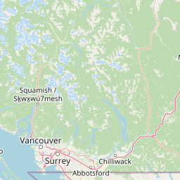
Map view of Emory Creek Provincial Park

Use this park location map to pinpoint Emory Creek Provincial Park in Canada, understand its exact geographic position, and read its mapped placement within the surrounding landscape more clearly.

Pigeon | © OpenStreetMap contributors

Location context for Emory Creek Provincial Park

British Columbia
Recorded earthquake history

Explore Historical Earthquake Records near Emory Creek Provincial Park

Navigate the complete historical catalog of seismic events associated by location with Emory Creek Provincial Park. MoriAtlas maintains these records to provide clear geographic and historical context for the Fraser Canyon region without presenting diagnostic hazard assessments.

Emory Creek Provincial Park Earthquake History

Catalogued events

3 events

Strongest magnitude

Magnitude 3.3

Most recent event

Aug 19, 2017

This history includes earthquakes recorded inside the park or within 50 km of its borders

Park atlas

Compare regional canyon terrain and connected riverside conservation landscapes

Explore Protected Areas and Parks Near Emory Creek Provincial Park in British Columbia

Browsing other protected areas near Emory Creek Provincial Park reveals broader geographic patterns across the Fraser Canyon corridor. Comparing adjacent river valley reserves helps place local historic sites within wider regional terrain contexts.
A pale, minimalist watercolor illustration of a soft, hazy landscape featuring rolling mountains in the distance, low-lying green shrubs, and rocky terrain along a shoreline.
State or regional parkBritish Columbia
14 km away#1 closest

South

Coquihalla Canyon Provincial Park: A Deeply Eroded Granite Gorge in British Columbia

Mapping historic railway tunnels and river canyon landscapes

Trace the winding Coquihalla River as it cuts through ancient volcanic and metamorphic bedrock. This park preserves a unique intersection of industrial heritage and river morphology, showcasing four iconic tunnels bored through solid granite that define this section of the British Columbia interior landscape.

Area
1.59 km²
Established
1986
IUCN
III
Relief
Upland
A wide watercolor painting showing layers of purple mountains in the distance, a misty valley, and green pine trees in the foreground under a pale pink and yellow sky.
Protected landscapeBritish Columbia
About 23 km away#2 closest

Northeast

Coquihalla Summit Recreation Area: A Protected Landscape in the British Columbia Mountains

Mapping ecological transition zones and mountain terrain

Covering 5,750 hectares of rugged slopes and high-elevation ridges, Coquihalla Summit Recreation Area anchors a vital ecological transition between the coastal and interior climates of British Columbia. This mapped protected area offers a deep look into the granite peaks of the North Cascades and the historic remnants of transportation corridors spanning over a century.

Area
57.5 km²
Established
1987
Relief
Mountain
Scope
Terrestrial
A horizontal watercolor painting depicting a soft-focus mountain landscape with rolling green meadows, patches of coniferous forest, and distant pale mountains under a white sky.
State or regional parkBritish Columbia
32 km away#3 closest

Southeast

E. C. Manning Provincial Park: A Comprehensive Geographic Atlas and Protected Area Overview

Mountainous terrain and ecological transitions in southern British Columbia

Spanning the cross section of the Canadian Cascades, E. C. Manning Provincial Park preserves a high-elevation landscape of wildflowers, glacial valleys, and mountain ridges. The protected area links temperate coastal rainforests with the arid interior, providing a study in regional hydrology and subalpine ecology defined by the Hozameen Range and the northern reaches of the Pacific Crest Trail.

Area
836.71 km²
Established
1941
IUCN
II
Visitors
1.1M annual
State or regional parkBritish Columbia
About 43 km away#4 closest

Southwest

Ferry Island Provincial Park: Geography, Riparian Terrain, and Protected River Boundaries

A study of Fraser River alluvial landscapes and provincial park land use

Ferry Island Provincial Park provides a rare protected island setting along the Fraser River in British Columbia. Spanning 29 hectares near the Agassiz-Rosedale Bridge, this Class C park represents an important alluvial riparian ecosystem within the heavily cultivated Fraser Valley, offering key insights into regional river-corridor geography and protected land management.

Area
0.29 km²
Established
1963
IUCN
II
Access
Access unknown
State or regional parkBritish Columbia
About 50 km away#5 closest

Southwest

Kilby Provincial Park: Protected Riverfront Geography and Historic Sites in BC

A unique riparian landscape along the Harrison River

Kilby Provincial Park offers an intimate look at the flood plain geography of the Harrison River. The site features an elevated, boardwalk-linked heritage environment integrated with sandy riverfronts and seasonal wildlife corridors. This protected area stands out for its combination of historical pioneer preservation and river-based ecosystem monitoring within the Upper Fraser Valley region of British Columbia.

Area
0.03 km²
Established
1973
IUCN
II
Relief
Lowland
National parkWashington
56 km away#6 closest

South

North Cascades National Park: US National Park Protected Landscape and Geographic Context

Explore mapped boundaries and regional Washington geography.

Gain insight into North Cascades National Park, a vital US National Park located in Washington. This entry focuses on its protected land status, mapped geographic extent, and its role within the regional atlas. Users seeking to understand the park's landscape character, natural terrain, and its specific location in Washington will find this an essential point for detailed park geography exploration and protected area discovery.

Area
2,042.26 km²
Established
1968
IUCN
II
Visitors
16.5K annual
A watercolor painting showing a panoramic view of mountain peaks in the distance above green foothills and plains.
Protected landscapeWashington
57 km away#7 closest

South

Mount Baker, Snoqualmie National Forest: Mapped Geography and Protected Landscape Analysis

Exploratory atlas of Washington's primary Cascade Range wilderness

Delve into the structural geography of Mount Baker, Snoqualmie National Forest. This protected area corridor serves as a major ecological transition zone between the Puget Sound lowlands and the interior Cascades, characterized by extensive glaciers, wild river systems, and iconic stratovolcanoes that define the regional landscape of Washington state.

Area
6,978 km²
Established
1974
Relief
Mountain
Climate
Alpine
A horizontal watercolor painting showing a range of purple-tinted mountain peaks above a green forest and a light pinkish shoreline.
Wildlife reserveWashington
57 km away#8 closest

South

Mount Baker Wilderness: Mapped Volcanic Peaks and Glacial Geography in Washington State

Protected wilderness boundaries in the Northern Cascades

Mount Baker Wilderness encompasses a vast mountain landscape characterized by an active stratovolcano and significant permanent snowfields. The terrain features a vertical gradient from dense west side conifer forests to exposed alpine summits, creating a distinct ecological corridor connected to neighboring protected areas in the Pacific Northwest.

Area
485.58 km²
Established
1984
IUCN
Ib
Relief
Mountain

Common questions about visiting, size, designation, and location context for Emory Creek Provincial Park

Emory Creek Provincial Park FAQs for park facts, access, geography, and protected area context

Find quick answers about Emory Creek Provincial Park, including protected-area facts, park geography, trail and visitor context, and how the park fits into its surrounding country and regional landscape.
MoriAtlas Explorer

Continue Your Protected Areas Search Across the Global Atlas

Deepen your exploration by continuing the structured search for national parks and protected areas worldwide. Utilize the comprehensive filtering capabilities to compare different conservation landscapes and refine your understanding of global park geography. Discover more about the distribution and characteristics of protected natural areas.

Global natural geography