Mori Atlas logo
Wildlife reserveEncampment River Wilderness

A rugged wilderness corridor defining the river geography of the Medicine Bow National Forest

Encampment River Wilderness: Mapped Protected Canyon Landscapes in South Central Wyoming

Encampment River Wilderness is a federally protected landscape in south central Wyoming that preserves a continuous, roadless river canyon corridor. Situated within the Medicine Bow National Forest, this area features steep canyon walls and a dense coniferous forest riparian habitat. The terrain follows the natural drainage of the Encampment River, offering a focused look at the canyon geography and layered topography of the southern Rocky Mountain foothills.

wilderness areariver canyonMountain WestMedicine Bow National Forestconiferous forestriparian habitat

Encampment River Wilderness

Wildlife reserve

Park overview

Structured park overview, official facts, and landscape profile for Encampment River Wilderness

Encampment River Wilderness park facts, protected area profile, and essential visitor context

Review the core facts for Encampment River Wilderness, including designation, size, terrain, visitor scale, habitats, and operating context in one park-focused overview.

About Encampment River Wilderness

The Encampment River Wilderness occupies a relatively small but ecologically meaningful corridor within the Medicine Bow National Forest, focusing protection on the Encampment River and its canyon. Designated in 1984, the wilderness falls under the framework of the U.S. National Wilderness Preservation System and is managed by the U.S. Forest Service. Its purpose is closely tied to the river itself: the surrounding canyon and forested slopes form a continuous natural setting that supports the river's character and the wildlife that depends on it.

Because the area is fully embedded inside Medicine Bow National Forest, the Encampment River Wilderness functions less as a standalone destination and more as a designated zone of stricter protection within a larger working forest landscape. Its designation layers additional restrictions on top of the surrounding national forest management, removing the possibility of logging, mining, road building, or permanent structures inside its boundaries. The result is a tightly defined river wilderness that retains its forested canyon setting with minimal human alteration.

The wilderness draws visitors who are looking for roadless river scenery and traditional low-impact recreation such as hiking, camping, fishing, and seasonal hunting. With its modest footprint and clear topographic focus on a single river canyon, the Encampment River Wilderness reflects the classic small-scale U.S. wilderness concept: a compact protected unit built around one well-defined natural feature.

Quick facts and research context for Encampment River Wilderness

Located in Carbon County in south central Wyoming, the Encampment River Wilderness lies within the Medicine Bow National Forest and is centered on the canyon of the Encampment River. It was designated in 1984 as part of the National Wilderness Preservation System and is managed by the U.S. Forest Service. The wilderness covers roughly 10,124 acres and is classified under IUCN Category Ib, recognizing it as a protected area with limited human interference.

Protection and recognition

Terrestrial protected area conservation background established in 1984

Encampment River Wilderness Protection Status and Designated History

Encampment River Wilderness maintains documented terrestrial protected area status established in 1984 without assigned international recognition programs. Structured records outline the formal designation history and baseline management scope governing the regional landscape.

Protection details

Protection scope
Terrestrial
Designated year
1984
Transboundary protection
No
Park context

Deeper park guide and search-rich context for Encampment River Wilderness

Encampment River Wilderness history, landscape, wildlife, and travel context

Explore Encampment River Wilderness through its history, landscape character, ecosystems, wildlife, conservation priorities, cultural context, and seasonal travel timing in a structured park guide built for atlas discovery and search intent.

Why Encampment River Wilderness stands out

The wilderness is best known for protecting the canyon corridor of the Encampment River within the Medicine Bow National Forest. Its defining character is the interplay between the river, the steep canyon walls, and the surrounding coniferous forest that lines the drainage. The area is also notable as a quiet, roadless complement to the larger Medicine Bow landscape, offering a focused river-wilderness experience in south central Wyoming.

Encampment River Wilderness history and protected-area timeline

The Encampment River Wilderness was established in 1984 as part of the ongoing expansion of the U.S. National Wilderness Preservation System. Its designation followed the framework set out in the 1964 Wilderness Act, which prohibits motorized or mechanized access, commercial resource extraction, and the construction of roads or permanent structures within designated wilderness lands.

The area's selection as a wilderness reflected a desire to give the Encampment River canyon and its surrounding forests a higher level of ecological protection than ordinary national forest management could provide. By placing the canyon under wilderness status, the U.S. Forest Service was able to preserve the river corridor and its forested slopes in a more natural, roadless condition, while still allowing traditional low-impact recreation such as hiking, camping, fishing, and seasonal hunting where compliant with wilderness regulations.

Encampment River Wilderness landscape and geographic character

The landscape of the Encampment River Wilderness is shaped almost entirely by the Encampment River and the canyon it has cut into the surrounding terrain. Steep canyon walls rise along the river's path, creating a narrow, sheltered corridor that contrasts with the broader forested ridges of the surrounding Medicine Bow National Forest.

The drainage is lined with coniferous forest typical of the southern Rocky Mountain foothills, where pines, spruces, and other evergreens mix with patches of aspen and riparian vegetation along the riverbanks. The terrain is characterized by elevation changes between the river, the canyon slopes, and the upper forest, giving the wilderness a layered topography that is compact but visually varied.

Because the wilderness follows the river's course rather than enclosing a wide plateau or broad basin, its scenery is a near-continuous sequence of canyon views, forested slopes, and river-side settings. This tightly defined landscape is what gives the Encampment River Wilderness its focused sense of place within south central Wyoming.

Encampment River Wilderness ecosystems, habitats, and plant life

The ecological identity of the Encampment River Wilderness is closely tied to its river canyon setting. The Encampment River itself supports a ribbon of riparian habitat, while the canyon walls and surrounding slopes are cloaked in coniferous forest typical of the southern Rocky Mountains. Together, these habitats form a continuous natural corridor along the river's length.

The mix of riparian vegetation, dense evergreen stands, and rocky canyon terrain creates a varied environment for wildlife despite the wilderness's modest size. The river acts as a central ecological thread, providing water, cover, and movement corridors for animals, while the surrounding forest offers additional habitat structure on the slopes above the drainage. Elevational changes between the river bottom and the upper forest add further ecological diversity within a relatively small footprint.

Because the area is fully embedded within Medicine Bow National Forest, the wilderness functions as a high-protection enclave within a broader forested landscape, allowing natural processes along the river and its canyon to proceed with minimal direct human disturbance.

Encampment River Wilderness wildlife and species highlights

The Encampment River Wilderness supports wildlife typical of forested river canyons in the southern Rocky Mountains. The combination of riparian habitat along the Encampment River and the surrounding coniferous forest creates conditions for both aquatic and terrestrial species.

The river itself is a focal habitat for fish and other aquatic life, while the canyon slopes and forested ridges provide cover and forage for land-based wildlife such as elk, mule deer, and a range of smaller mammals. Birdlife is associated with both the dense forest and the open river corridor, including species adapted to mountain canyons and flowing water.

Because the area is managed as roadless wilderness with restricted human activity, the wildlife of the Encampment River Wilderness experiences relatively low levels of direct disturbance compared to more accessible parts of the surrounding national forest. This contributes to its value as a refuge for species that benefit from quieter, less fragmented habitat.

Encampment River Wilderness conservation status and protection priorities

The conservation significance of the Encampment River Wilderness lies in its protection of the Encampment River canyon as a continuous, roadless natural corridor within Medicine Bow National Forest. Wilderness designation under the 1964 Wilderness Act adds a strong layer of legal protection that goes beyond standard national forest management.

Within its boundaries, commercial activities such as logging and mining are prohibited, and there are no roads or permanent structures. Mechanized and motorized uses, including bicycles, are not permitted, reducing physical disturbance to the river and surrounding forest. These restrictions help protect water quality, riparian vegetation, and wildlife habitat along the canyon.

The wilderness also contributes to broader conservation networks in the Medicine Bow landscape by preserving an undeveloped river corridor that anchors ecological connectivity in the drainage. Its IUCN Category Ib designation reflects its role as a protected area where ecological processes are allowed to continue with minimal direct human interference.

Top sights and standout views in Encampment River Wilderness

A focused wilderness centered on the Encampment River canyon in south central Wyoming, fully embedded within Medicine Bow National Forest. Designated in 1984 under the framework of the 1964 Wilderness Act and managed by the U.S. Forest Service, it preserves a roadless, log-free, and mining-free natural corridor along the river. Its combination of canyon scenery, coniferous forest, and traditional low-impact recreation opportunities makes it a compact but characterful example of U.S. river wilderness.

Best time to visit Encampment River Wilderness

The Encampment River Wilderness is shaped by the strong seasonality of south central Wyoming. Summer is typically the most accessible period, when snow has melted from the lower elevations and the canyon trails, riverbanks, and surrounding forest are most easily reached for hiking, camping, and fishing. Longer daylight hours and warmer temperatures also make high-country approaches more practical.

Spring and early summer can bring high water in the Encampment River from snowmelt, which can affect fishing conditions and make some canyon sections more challenging to traverse. Fall offers cooler temperatures, reduced insect activity, and the visual change of autumn color in the aspen and other deciduous growth along the canyon, paired with the hunting season that is permitted under wilderness rules.

Winter brings heavy snow to the Medicine Bow region, and the roadless character of the wilderness means that access becomes substantially more difficult for most visitors, with snow-covered terrain, limited daylight, and cold temperatures defining the experience for any winter users.
Monthly climate preview

Long-term monthly temperature and precipitation averages for Wyoming terrain

Encampment River Wilderness Climate Normals and Annual Temperature Rhythm

Representative coordinate records show measured monthly temperature variation from sub-zero winter minimums to mild summer highs alongside steady annual precipitation patterns. Accessing the complete twelve-month profile provides detailed averages across all temperature and precipitation metrics for this Wyoming location.
Annual mean2 °C
-11 °C17 °C
Jan-11°
Feb-10°
Mar-5°
Apr
May
Jun12°
Jul17°
Aug15°
Sep10°
Oct
Nov-5°
Dec-10°
Warmest month
July

16.7 °C

Coolest month
January

-10.7 °C

Wettest month
April

2.4 mm/day

Driest month
July

1.1 mm/day

Park location guide

Geography guide, regional context, and park location map for Encampment River Wilderness

Encampment River Wilderness park geography, regions, and map view in United States of America

Understand where Encampment River Wilderness sits in United States of America through a broader geographic reading of the surrounding landscape, nearby location context, and its mapped position within the national park landscape.

How Encampment River Wilderness fits into United States of America

The United States of America is a federal presidential republic and one of the world's largest countries by area and population. It consists of 50 states across a vast territory spanning multiple time zones, with its capital in Washington, D.C. and largest city in New York City. The nation has a diverse economy, influential political system, and significant cultural and military presence globally.

Wider geography shaping Encampment River Wilderness in United States of America

The United States occupies a vast territory in North America, bordered by Canada to the north and Mexico to the south. The 48 contiguous states stretch from the Atlantic to the Pacific Ocean, while Alaska occupies the northwestern region and Hawaii is an archipelago in the Pacific. The country encompasses diverse terrain including the Rocky Mountains, Appalachian Mountains, Great Plains, and extensive river systems.

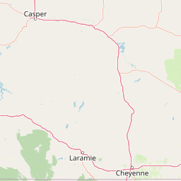
Map view of Encampment River Wilderness

Use this park location map to pinpoint Encampment River Wilderness in United States of America, understand its exact geographic position, and read its mapped placement within the surrounding landscape more clearly.

Pigeon | © OpenStreetMap contributors

Location context for Encampment River Wilderness

Wyoming
Recorded earthquake history

Explore the Historical Earthquake Records for Encampment River Wilderness

Investigate the documented seismic history of the terrain surrounding Encampment River Wilderness through our historical catalogue. MoriAtlas provides access to recorded epicentre data, magnitude logs, and location metrics to support your geographic exploration of the southern Rocky Mountain foothills.

Encampment River Wilderness Earthquake History

Catalogued events

15 events

Strongest magnitude

Magnitude 3.8

Most recent event

Sep 14, 2024

This history includes earthquakes recorded inside the park or within 50 km of its borders

Park atlas

Discover related protected areas and regional wilderness corridors across south central Wyoming

Explore Parks Near Encampment River Wilderness and Surrounding Mountain Landscapes

Browsing other parks near Encampment River Wilderness reveals interconnected mountain forests and protected river canyons throughout the regional landscape. Expanding the geographic comparison provides deeper context into the diverse protected terrain shared across the southern Rocky Mountain foothills.
Protected areaWyoming
2.2 km away#1 closest

West

Huston Park Wilderness: Atlas Exploration of Wyoming Protected Mountain Terrain

Examining the high-country forest and alpine geography of the Medicine Bow region.

Huston Park Wilderness serves as a protected sanctuary for the coniferous forests and rocky ridges of central Wyoming. This atlas entry provides geographic insights into its 30,000 acres of subalpine wilderness, tracing how its mountain terrain remains preserved within the Medicine Bow National Forest without human development.

Area
123.79 km²
Established
1984
IUCN
Ib
Relief
Mountain
A watercolor illustration of a mountain range with soft, pastel-colored peaks in the background and a green treeline in the foreground.
Wildlife reserveColorado
4.1 km away#2 closest

South

Mount Zirkel Wilderness: Protected Mountain Geography and Forested Landscape Overview

A study of high elevation terrain in the Colorado Rocky Mountains.

Mount Zirkel Wilderness stands as a primary protected area within the Colorado Rocky Mountains. The landscape is defined by the Encampment River headwaters, glaciated alpine basins, and the characteristic ribbon forests formed by extreme snowfall. This analysis explores the metamorphic bedrock and forest composition across the high ridges near the Continental Divide, providing a clear view of the park boundaries and regional environmental features.

Area
647.23 km²
Established
1980
IUCN
Ib
Relief
Mountain
A horizontal watercolor painting depicting a winding river flowing through a green valley with purple-tinted mountain ranges in the background.
Wildlife reserveWyoming
25 km away#3 closest

East

Platte River Wilderness: Geography and Protected Landscape Atlas

Mapping wild river corridors and mountain forest terrain across Wyoming and Colorado.

Platte River Wilderness preserves a vital stretch of the North Platte River, carving through mountain ranges with steep canyon walls and rocky gorges. The terrain offers a distinct profile of conifer forests and shifting river landscapes. This protected area stands as a primary example of wilderness administration, managing complex river-based topography and regenerating mountain habitat for regional wildlife populations.

Area
95.07 km²
Established
1984
IUCN
Ib
Relief
Mountain
A horizontal watercolor painting showing a range of purple and reddish-toned mountains in the distance, behind rolling green fields and a pale pinkish waterway in the foreground.
Protected landscapeColorado
47 km away#4 closest

Southeast

Roosevelt National Forest: Mapping Wilderness and Protected Landscapes in Northern Colorado

Regional geography, river corridors, and alpine mountain terrain

Roosevelt National Forest encompasses a significant protected landscape across Larimer, Boulder, Gilpin, and Jefferson counties. The forest features a complex terrain of deep canyons, forested plateaus, and protected wilderness areas that form a scenic buffer along the eastern side of the Continental Divide and Rocky Mountain National Park.

Area
3,293.33 km²
Established
1902
Relief
Mountain
Climate
Subpolar
A horizontal watercolor painting showing a soft mountain range in the distance, a midground forest, and a foreground area suggesting marshy ground or a meadow.
Wildlife reserveColorado
96 km away#5 closest

Southeast

Never Summer Wilderness: Protected Mountain Geography and Alpine Terrain in Colorado

High-altitude wilderness along the Continental Divide

Spanning over 21,000 acres, the Never Summer Wilderness defines a critical segment of the Colorado Rockies. This protected area features a jagged skyline of 12,000-foot summits, extensive alpine tundra, and the remarkable old-growth spruce and fir forests of Bowen Gulch. Use these maps to understand its role as a vital headwater landscape and its position as a sanctuary for alpine wildlife and ecosystems.

Area
85.3 km²
Established
1980
IUCN
Ib
Relief
Mountain
National parkColorado
98 km away#6 closest

Southeast

Rocky Mountain National Park: National Park Protected Landscape in Colorado

Explore its mapped boundaries and regional geographic context.

Rocky Mountain National Park is a designated National Park within Colorado, crucial for understanding the distribution and geographic context of protected areas in the United States. This detail page provides an atlas-oriented perspective, emphasizing the park's mapped boundaries and its place within the natural landscape of the region. It is designed to facilitate a clear understanding of the park's protected status and its contribution to the atlas of natural landscapes, offering factual insights for geographic discovery.

Area
1,074.28 km²
Established
1915
IUCN
II
Visitors
4.2M annual
Protected landscapeGrand County
115 km away#7 closest

Southeast

Arapaho National Recreation Area: Geographic Profile and Protected Landscape Context

High-country mountain reservoirs and forested mountain terrain

The Arapaho National Recreation Area defines a unique intersection of montane forest and water-based geography in Grand County, Colorado. As the home to the Great Lakes of Colorado, this protected landscape provides a critical connection point between the Colorado River headwaters and the Continental Divide. Examine the park's terrain, reservoir distribution, and its role as a forested gateway to the neighboring mountain regions.

Area
124.2 km²
Established
1978
Relief
Mountain
Climate
Alpine
A soft watercolor illustration featuring rolling, flat-topped mountains in the background and a dense line of coniferous trees across the foreground.
Protected areaUnited States of America
About 125 km away#8 closest

South

Flat Tops Wilderness: Protected Geographic Landscapes of the Colorado Rockies

High-altitude volcanic plateaus and glaciated terrain

Spanning 235,000 acres, Flat Tops Wilderness stands out as a foundational protected area in Colorado. Its unique basalt cap, carved by glacial activity into an array of high-country lakes and distinctive ridges like the Devils Causeway, creates a rare geographic profile. This overview details the structural features and regional terrain that distinguish this wilderness from the surrounding Rocky Mountain summits.

Area
951.88 km²
Established
1975
Relief
Mountain
Climate
Alpine

Common questions about visiting, size, designation, and location context for Encampment River Wilderness

Encampment River Wilderness FAQs for park facts, access, geography, and protected area context

Find quick answers about Encampment River Wilderness, including protected-area facts, park geography, trail and visitor context, and how the park fits into its surrounding country and regional landscape.
MoriAtlas Explorer

Continue Your Protected Areas Search Across the Global Atlas

Deepen your exploration by continuing the structured search for national parks and protected areas worldwide. Utilize the comprehensive filtering capabilities to compare different conservation landscapes and refine your understanding of global park geography. Discover more about the distribution and characteristics of protected natural areas.

Global natural geography