
Mori Atlas logo
Nature reserveErpeler Ley

Mapping the geological remnants and protected cliffside habitats of this iconic landmark.

Erpeler Ley Nature Reserve: A Volcanic Basalt Landmark Along the Middle Rhine Valley

Erpeler Ley stands as a distinctive volcanic remnant on the eastern bank of the Rhine, defined by its steep columnar basalt formations and diverse thermophilic flora. This protected nature reserve provides a unique vantage point over the Middle Rhine, tracing the intersection of ancient lava flows and the regional landscape history of Rhineland-Palatinate. It remains a key focal point for observing the geological and ecological patterns that shape the river valley.

basalt cliffMiddle Rhinevolcanic remnantVulkanruinenature reserveNaturschutzgebiet
A stylized vector illustration showing a tall, light red cliff overlooking a winding river with a small village nestled on the opposite bank under a soft pastel sky.

Erpeler Ley

Nature reserve

Park overview

Structured park overview, official facts, and landscape profile for Erpeler Ley

Erpeler Ley park facts, protected area profile, and essential visitor context

Review the core facts for Erpeler Ley, including designation, size, terrain, visitor scale, habitats, and operating context in one park-focused overview.

About Erpeler Ley

The Erpeler Ley is a compact but unusually layered landmark on the Middle Rhine, combining geological drama with ecological protection, wartime memory, and everyday recreation. Sitting on the right bank of the river just north of the village of Erpel, the basalt cliff rises to 191 metres above sea level and forms a near-vertical wall guarding the approach to the Ahr valley mouth on the far shore.

Like other Vulkanruinen in the region, the Erpeler Ley represents the eroded core of much older volcanic activity. Lava flows that once spread across the area cooled slowly within their interior, producing columnar jointing that is now exposed along the cliff. Several sections of the rock face show a striking fan-like arrangement of columns, which geologists interpret as the result of multiple phases of lava intrusion and uneven solidification. The result is a textbook example of late-stage volcanic landforms within the Middle Rhine cultural landscape.

Human activity around the Erpeler Ley goes back to Roman times, when the rock was already quarried for building stone. The cliff's modern identity, however, began to take shape in the early twentieth century, when it gradually became a destination for hiking, sightseeing, and local gatherings. Today the plateau can be reached by car from the B42, is marked as a waypoint on the Rheinsteig long-distance trail and the local Rotbäckchen hiking route, and continues to host community events ranging from athletics days and old-timer meetings to the annual Sankt-Martin fire.

The site also carries significant memorial value. Below the cliff stand the surviving towers of the Ludendorff Bridge at Remagen, and on the plateau a wooden cross commemorates those who fell in the fight for the crossing in the final phase of the Second World War. A nearby railway tunnel, once used as a wartime shelter, passes entirely through the rock. A Zeppelin memorial stone recalls Count Zeppelin's flight of 2 August 1909, while a Burschenschaft monument and a basalt memorial to the local teacher and conservationist Hans Eich round out the collection of stones and markers that give the plateau much of its present-day character.

Quick facts and research context for Erpeler Ley

The Erpeler Ley is a basalt cliff on the right bank of the Rhine near Erpel, in the Landkreis Neuwied in Rhineland-Palatinate, Germany. It rises to 191 metres above sea level, with its rock face standing roughly 136 metres above the river surface.

The formation is one of the best-known Vulkanruinen, or volcanic remnants, in the Middle Rhine Valley, sitting alongside the Drachenfels across the river. It has been a designated nature reserve (Naturschutzgebiet) since 1941, recognised for its warm-climate flora and fauna as well as its geological value.

Protection and recognition

Documented terrestrial protection history established in 1941

Erpeler Ley Protection Status and Mapped Designation Records

Erpeler Ley maintains a documented terrestrial protection status established in 1941 without transboundary or international recognition sources. Reviewing these verified designation records provides clear insight into the conservation framework governing this landscape.

Protection details

Protection scope
Terrestrial
Designated year
1941
Transboundary protection
No
Park context

Deeper park guide and search-rich context for Erpeler Ley

Erpeler Ley history, landscape, wildlife, and travel context

Explore Erpeler Ley through its history, landscape character, ecosystems, wildlife, conservation priorities, cultural context, and seasonal travel timing in a structured park guide built for atlas discovery and search intent.

Why Erpeler Ley stands out

The Erpeler Ley is best known for its dramatic columnar basalt, formed from lava that cooled unevenly inside an ancient volcanic flow and produced distinctive fan-shaped patterns across the cliff. It is also well known as one of the most visually striking Vulkanruinen of the Middle Rhine, with a panoramic view that sweeps from the Siebengebirge past the Ahr confluence and into the distant Eifel. In addition to its geology, the cliff is known for its protected heat-loving plant and animal communities, including gold aster, feather grass, rock bunting, and peregrine falcon. The plateau above carries multiple memorials: a Second World War cross recalling the battle for the Ludendorff Bridge, a Zeppelin memorial stone, a Burschenschaft monument, and a basalt memorial to the local conservation advocate Hans Eich.
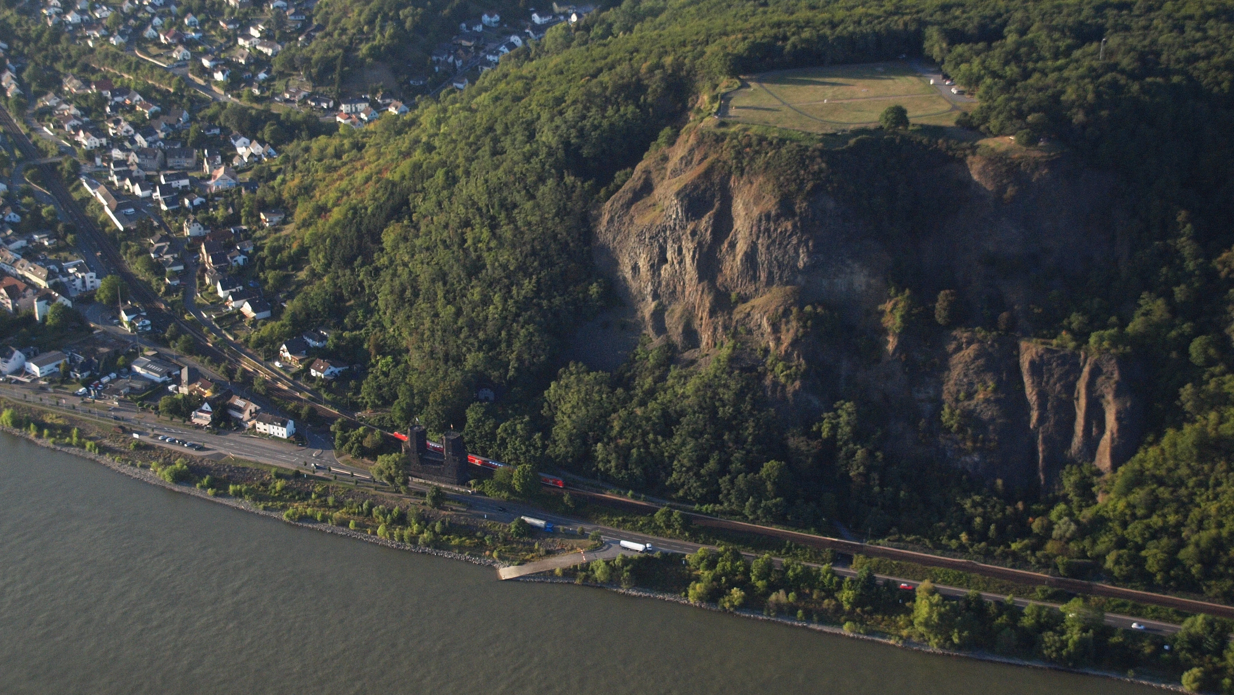
Aerial view of Erpeler Ley, a prominent basalt cliff face rising above the Rhine river, with the town of Erpel visible at the base.
Aerial view of the Erpeler Ley basalt formation overlooking the Rhine river.

Erpeler Ley history and protected-area timeline

The history of the Erpeler Ley stretches back to Roman times, when its hard basalt was already being quarried for building purposes along the Rhine. In the centuries that followed, the cliff remained part of the working Rhine landscape rather than a tourist attraction, valued primarily for the stone it could yield.

Its modern significance began to grow in the nineteenth and early twentieth centuries alongside the wider Romantic and scientific discovery of the Middle Rhine. On 2 August 1909, the airship LZ 5 (Z II), returning from the Frankfurt ILA exhibition to the airship port at Cologne, was forced to turn back over the Erpeler Ley after encountering a storm; a memorial stone on the plateau still marks this event. The years around the First and Second World Wars brought heavier history to the site, as the Ludendorff Bridge at nearby Remagen became one of the most storied crossings of the final phase of the Second World War. A wooden cross on the plateau honours those who fell in the fighting, while the disused railway tunnel bored through the lower cliff served as a wartime shelter for local civilians.

In 1941, the Erpeler Ley was placed under formal nature protection, recognising both its volcanic geology and its unusually rich warmth-loving flora and fauna. Since then, the plateau has been gradually developed for public use, with maintained trails, an ash athletics track, parking areas, and the traditional Gaststätte Bergesruh inn. Community events, including athletics competitions, old-timer and buggy gatherings, a recurring amateur radio Fieldday, and the regional Brücken-Festival since 2008, have become part of the annual rhythm of the site, while the Sankt-Martin wooden-tower fire tradition has been preserved by the municipality of Erpel since 2008.

Erpeler Ley landscape and geographic character

The defining landform of the Erpeler Ley is its steep basalt cliff, which rises almost vertically from a narrow strip of the right bank of the Rhine. The rock face climbs to roughly 136 metres above the river, with the summit reaching 191 metres above sea level, producing a sharp promontory that breaks the otherwise gentler river plain between Remagen and Unkel.

Geologically, the cliff is the eroded remnant of an ancient lava flow whose interior cooled slowly enough to develop extensive columnar jointing. In several places, the columns fan outward in a radial pattern, indicating that lava was injected in more than one phase and solidified unevenly against the surrounding rock. Once-quarried galleries and an exploratory adit, now partly open and reportedly not safe to enter, cut into the cliff halfway up and recall the long period during which the basalt was mined for construction.

From the plateau, the landscape opens into one of the classic Middle Rhine panoramas. To one side lie the hills of the Siebengebirge with the town of Unkel in the foreground; along the river, the view passes over the Goldene Meile on the opposite bank and the Roman town of Remagen, then crosses the mouth of the Ahr to reach the town of Linz am Rhein. On clear days, the view extends deep into the Eifel, layering the protected natural area into the broader panorama of the Middle Rhine valley.
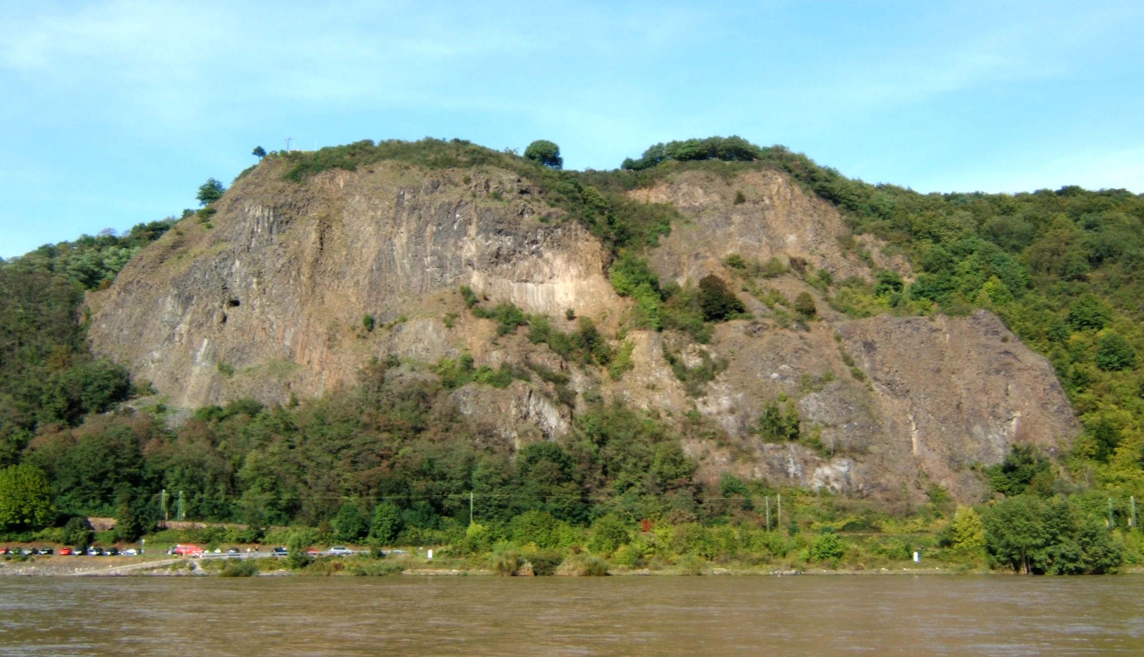
A wide view of the Erpeler Ley basalt rock formation rising prominently above the Rhine River, with trees and greenery covering parts of the cliff face.
The basalt cliffs of Erpeler Ley overlooking the Rhine River.

Erpeler Ley ecosystems, habitats, and plant life

Ecologically, the Erpeler Ley is recognised primarily as a refuge for warmth-loving, or thermophilic, plant and animal communities that thrive on its dry, sun-exposed basalt slopes. Since 1941, the site has been protected as a Naturschutzgebiet in the Landkreis Neuwied, in large part because of these unusually rich communities in a landscape otherwise dominated by river and woodland habitats.

The exposed basalt retains heat and drains quickly, creating microclimatic conditions suitable for species that would not otherwise flourish along this stretch of the Rhine. Vegetation on and around the cliff includes drought-resistant herbs and grasses typical of continental-warm rocky habitats, while open ground and scrub on the plateau support further thermophilic flora. These habitats together form a small but ecologically distinct island within the broader Middle Rhine cultural landscape.

Together with the rocks themselves, the plateau meadows, woodland fringes, and former quarry workings create a mosaic of dry, warm, and shaded microhabitats within a compact area. This mosaic gives the Erpeler Ley a disproportionately high ecological value relative to its size, and helps explain its long-standing protected status.
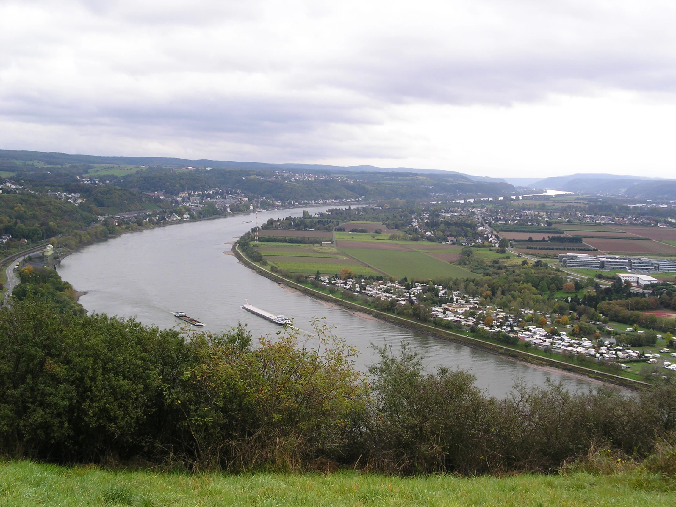
An elevated panoramic view looking down over a winding river with a barge, surrounded by green fields, small settlements, and dense vegetation under a cloudy sky.
Panoramic view over the Rhine River valley from the Erpeler Ley nature reserve.

Erpeler Ley wildlife and species highlights

The cliff face and rocky slopes of the Erpeler Ley provide nesting and hunting habitat for several bird species characteristic of warm, rocky habitats along the Rhine. The peregrine falcon is among the most notable species recorded here, using the cliff ledges as a base for hunting over the river valley. The rock bunting, another warmth-loving bird strongly associated with such habitats, is also present.

The combination of exposed rock, dry herbaceous vegetation, and surrounding woodland along the valley edge supports a broader community of invertebrates, reptiles, and small mammals typical of thermophilic habitats along the Middle Rhine. The site's protected status under the 1941 designation reflects in part the persistence and richness of these warmth-loving fauna alongside the unusual plant communities of the cliff.

Erpeler Ley conservation status and protection priorities

Since 1941, the Erpeler Ley has been designated as a Naturschutzgebiet, or nature reserve, within the Landkreis Neuwied, with official reference NSG-7138-026 in the list of protected areas of the district. The reserve was created to protect both the volcanic geology of the cliff and the unusually rich thermophilic flora and fauna found on its slopes.

The conservation value of the site lies in the combination of an exposed basalt landform and a microclimate that supports plant and animal communities uncommon in the surrounding Rhine valley. The geological columnar structures themselves, including the radial fan-like patterns visible in the rock, are part of the protected natural heritage of the area. Continued management balances protection of these scientific and ecological values with the site's heavy use for hiking, athletics, community events, and memorial visits, and the community of Erpel has long been involved in the care of paths, woodlands, and the historical features of the plateau.

Erpeler Ley cultural meaning and human context

The Erpeler Ley occupies a distinctive place in the cultural memory of the Middle Rhine, layered with both wartime and pre-war associations. Its most prominent historical trace is the battle for the nearby Ludendorff Bridge at Remagen in the closing phase of the Second World War; a wooden cross on the plateau honours those who fell, and the surviving bridge towers are still visible from the cliff. The disused railway tunnel bored through the lower cliff, which served as a civilian shelter during the fighting, gives the site a tangible link to that period.

Earlier associations are also visible on the plateau. A basalt memorial stone recalls Count Zeppelin's flight of 2 August 1909, when his airship was forced to turn back over the Erpeler Ley because of a storm on the way from the Frankfurt ILA to the Cologne airship port. A monument of three concrete-cast basalt stelae was dedicated by the Bonner Burschenschaft Rheno-Germania, marking its refoundations within the Schwarzburgbund. A further basalt memorial honours Hans Eich, a former Erpel primary school teacher remembered above all for his work in nature protection and in preserving local traditions.

The plateau also remains a venue for community traditions maintained by the village of Erpel, including the annual Sankt-Martin fire. Until 2007 the fire tradition was run by the village youth; since then, the municipality has organised the burning of a 10 to 12-metre tower of wooden pallets on the plateau alongside the St Martin's procession in the village centre.

Top sights and standout views in Erpeler Ley

The Erpeler Ley is distinguished by the combination of volcanic geology, a designated nature reserve, and a layered cultural and memorial landscape within a single compact site. Its columnar basalt, in several places arranged in striking fan-shaped patterns, makes it a textbook example of the Vulkanruinen that line the Middle Rhine, while the protected thermophilic flora and fauna of the cliffs add a strong ecological dimension.

Equally important is the site's panoramic view over the Middle Rhine, stretching from the Siebengebirge and the Ahr confluence past Remagen and Linz am Rhein deep into the distant Eifel. The plateau above carries an unusually dense collection of memorials and local traditions, from the Second World War cross and the old railway tunnel, to the Zeppelin stone, the Burschenschaft monument, and the annual Sankt-Martin fire, making it a place where geology, nature, and regional memory meet.

Best time to visit Erpeler Ley

Spring and early summer are particularly rewarding at the Erpeler Ley, when the cliff-top meadows and warm basalt slopes come into bloom and the thermophilic plant communities for which the site is protected are at their most visible. Autumn offers a different character, with clearer air over the Rhine valley that favours the famous wide panorama toward the Siebengebirge and the Eifel.

Visitors interested in local traditions may time a visit around the annual Sankt-Martin fire on the first Friday in November, while the regular Easter and St Nicholas running events, the old-timer and buggy gatherings, and the Brücken-Festival bring extra activity to the plateau at various points in the year. Daylight hours are generally the best times for appreciating both the rock topography and the panoramic view.

Monthly climate preview

Long-term representative coordinate measurements trace thermal ranges and moisture distribution.

Erpeler Ley Climate Normals: Annual Temperature and Monthly Precipitation Rhythms

Erpeler Ley exhibits an annual temperature range spanning sub-zero winter minimums to warm summer maximums alongside steady daily precipitation rates. Examining the full twelve-month profile provides deeper analytical context for long-term climatological conditions.
Annual mean9 °C
0 °C19 °C
Jan
Feb
Mar
Apr
May13°
Jun16°
Jul19°
Aug18°
Sep14°
Oct
Nov
Dec
Warmest month
July

18.7 °C

Coolest month
January

0 °C

Wettest month
December

2.5 mm/day

Driest month
April

1.6 mm/day

Park location guide

Geography guide, regional context, and park location map for Erpeler Ley

Erpeler Ley park geography, regions, and map view in Germany

Understand where Erpeler Ley sits in Germany through a broader geographic reading of the surrounding landscape, nearby location context, and its mapped position within the national park landscape.

How Erpeler Ley fits into Germany

Germany is a federal republic in Western and Central Europe with a population of over 83 million across sixteen constituent states. It is Europe's largest economy by nominal GDP and a major global exporter and importer. The capital is Berlin, and the country borders Denmark, Poland, Czech Republic, Austria, Switzerland, France, Luxembourg, Belgium, and the Netherlands.

Wider geography shaping Erpeler Ley in Germany

Germany is located in Western and Central Europe, spanning 357,022 km². It borders Denmark to the north, Poland and the Czech Republic to the east, Austria and Switzerland to the south, and France, Luxembourg, Belgium, and the Netherlands to the west. The country has coastlines on the Baltic Sea and North Sea to the north, with the Alps located in the southern region.

Map view of Erpeler Ley

Use this park location map to pinpoint Erpeler Ley in Germany, understand its exact geographic position, and read its mapped placement within the surrounding landscape more clearly.

Pigeon | © OpenStreetMap contributors

Location context for Erpeler Ley

Rhineland-Palatinate

Visual exploration of basalt cliffs, protected habitats, and Middle Rhine scenery

Erpeler Ley Photos and Volcanic Landscape Imagery

Photographic records capture the steep basalt cliffs, columnar rock formations, and protected heat-loving flora defining the Erpeler Ley. Visual documentation reveals the rugged terrain and sweeping river panoramas that characterize this volcanic landmark along the Middle Rhine.

Aerial view of Erpeler Ley, a prominent basalt cliff face rising above the Rhine river, with the town of Erpel visible at the base.

A steep, craggy cliff face showing distinct columnar basalt rock formations against a clear blue sky.

A wide view of the Erpeler Ley basalt rock formation rising prominently above the Rhine River, with trees and greenery covering parts of the cliff face.

An elevated panoramic view looking down over a winding river with a barge, surrounded by green fields, small settlements, and dense vegetation under a cloudy sky.

Park atlas

Compare regional volcanic remnants and connected nature reserves along the Middle Rhine valley.

Explore Parks Near Erpeler Ley and Surrounding Protected Landscapes

Browse other parks near Erpeler Ley to discover related geological formations, protected plant communities, and river valley terrain. Comparing these adjacent protected areas reveals the broader volcanic history and regional geography of the surrounding landscape.
A watercolor illustration of a river landscape featuring green plains, a winding river, and rolling hills in the background.
Nature reserveRhineland-Palatinate
About 3.4 km away#1 closest

Southeast

Naturschutzgebiet Mündungsgebiet der Ahr: Protected Delta and Fluvial Landscape

A dynamic nature reserve in the Rhineland-Palatinate river valley

Located in Sinzig, this protected nature reserve preserves the only remaining natural river-mouth delta of a Rhine tributary. The landscape is defined by continuous sediment deposition and erosion, allowing the Ahr to create a fluid, ever-changing environment of sandbanks and gravel bars. This reserve is essential for observing pioneer biocoenoses and floodplain dynamics within the broader context of Western German river geography.

Established
1981
Scope
Terrestrial
Water
Water-dominated
A horizontal watercolor painting depicting a gentle, hazy green landscape with rolling hills, a line of trees, and a foreground meadow.
Protected landscapeNorth Rhine-Westphalia
About 6.1 km away#2 closest

Northwest

Naturpark Rheinland: Geography and Protected Area Overview in North Rhine-Westphalia

A complex metropolitan nature park and lake district

Naturpark Rheinland represents a distinct convergence of reclaimed lignite mining landscapes, quiet lowland forests, and floodplain wetlands. Its mapped boundaries reveal a diverse terrain of ridges and river valleys that define the environmental character of the Cologne-Bonn metropolitan region.

Area
1,045 km²
Established
1959
Relief
Upland
Climate
Temperate
Nature reserveRheinland-Pfalz
About 13 km away#3 closest

South

Bausenberg Nature Reserve: Geological Scoria Cone and Volcanic Landscape in Rhineland-Palatinate

Protected Eifel volcanic terrain and ancient earthwork geography.

Bausenberg serves as a protected window into eastern Eifel volcanism, showcasing a classic scoria cone and horseshoe-shaped crater profile. Located between Niederzissen and Waldorf, this 127-hectare reserve preserves critical lava-flow remnants and rare habitats, offering a deep look at the volcanic and human history shaped into the landscape of Rhineland-Palatinate.

Area
1.27 km²
Established
1981
Relief
Mountain
Climate
Temperate
A pale, minimalist watercolor painting showing a winding river flowing through a forested valley with rolling hills in the background.
Protected landscapeRhineland-Palatinate
About 14 km away#4 closest

East

Naturpark Rhein-Westerwald: Protected Landscapes of the Middle Rhine and Westerwald Plateaus

A historic protected area spanning Rhine river slopes and volcanic ridges

Naturpark Rhein-Westerwald defines a critical geographic corridor in Rhineland-Palatinate, bridging the gap between the Rhine valley floor and the Westerwald highlands. This protected landscape preserves a sequence of volcanic ridges, dense mixed forests, and deep river valleys that serve as a testament to the region's complex geological history and long-standing conservation efforts.

Area
470 km²
Established
1962
Relief
Upland
Scope
Terrestrial
A soft watercolor painting depicting a panoramic landscape with rolling green hills, patches of forest, and gentle terrain.
Nature reserveNordrhein-Westfalen
About 17 km away#5 closest

Northwest

Kottenforst-Waldville Nature Reserve: Protected Landscape Geography and Forest Mapping

A significant oak-hornbeam woodland complex within Nordrhein-Westfalen.

Kottenforst-Waldville comprises extensive, interconnected forest blocks defined by their high-value oak-hornbeam stands and rare woodland pools known as Maare. This protected area supports a dense regional network of spring brooks and floodplain woodlands, serving as a critical refuge for woodpecker populations and raptors within the anthropogenically shaped landscape of the Rhine valley.

Area
35.853 km²
Established
2004
A horizontal watercolor painting showing a soft, minimalist landscape of a winding river surrounded by low green hills and floodplain vegetation on a white background.
Nature reserveRhineland-Palatinate
About 17 km away#6 closest

Southeast

Namedyer Werth Nature Reserve: A Geographical Overview of the Middle Rhine Floodplain

Examining riparian habitat, river dynamics, and protected terrain.

Namedyer Werth stands as a significant nature reserve on the left bank of the Middle Rhine, showcasing restored floodplain forest and important bird habitats. This compact landscape, once a river island, provides a fascinating look at how transport infrastructure and natural conservation coexist. Examine the site as a key component of the Rhine river geography, famous for the Andernach cold-water geyser and its layered environmental history.

Established
1985
Nature reserveNorth Rhine-Westphalia
About 18 km away#7 closest

Northwest

Melbtal Nature Reserve in North Rhine-Westphalia: Map, Terrain, and Geographic Context

Deep-cut forested valley with unique geological instability

Melbtal stands as a protected nature reserve in Bonn, Germany, defined by its steep wooded slopes and the meandering Melbbach. This geographic entity offers a study in earth-science dynamics, featuring active landslides and a distinct cold-air flow that persists within a dense urban setting. Use this atlas perspective to understand the boundaries, terrain, and layered cultural history of one of the region's most prominent green corridors.

Area
0.2 km²
Established
2013
IUCN
IV
Relief
Upland
A watercolor painting showing a reddish-brown layered geological formation, likely a quarry or volcanic cliff, topped with trees, with softer green hills in the distance.
Nature reserveRhineland-Palatinate
About 18 km away#8 closest

South

Nastberg Nature Reserve: Volcanic Geology and Protected Landscapes in Rhineland-Palatinate

Tracing volcanic fissures and scoria cone history in the Middle Rhine region

Nastberg represents a significant geological site within the Vulkanpark network. The nature reserve exposes complex layers of tuff and scoria, documenting a long history of explosive activity. With views extending across the Neuwied Basin toward the Westerwald and Hunsrück, this site offers deep insight into the regional volcanic geography of western Germany.

Relief
Mountain
Climate
Temperate
Access
Easy access
Scope
Terrestrial

Common questions about visiting, size, designation, and location context for Erpeler Ley

Erpeler Ley FAQs for park facts, access, geography, and protected area context

Find quick answers about Erpeler Ley, including protected-area facts, park geography, trail and visitor context, and how the park fits into its surrounding country and regional landscape.
MoriAtlas Explorer

Continue Your Protected Areas Search Across the Global Atlas

Deepen your exploration by continuing the structured search for national parks and protected areas worldwide. Utilize the comprehensive filtering capabilities to compare different conservation landscapes and refine your understanding of global park geography. Discover more about the distribution and characteristics of protected natural areas.

Global natural geography