
Mori Atlas logo
Nature reserveEschefelder Teiche

Examining the historic chain of artificial ponds and regional waterbird habitats across the Saxon landscape

Eschefelder Teiche: A Protected Pond Landscape and Wetland Nature Reserve in Sachsen, Germany

(Naturschutzgebiet Eschefelder Teiche)

Eschefelder Teiche represents a significant nature reserve in the southern Leipzig district of Sachsen, characterized by an extensive 18th-century pond landscape. This area provides vital staging, breeding, and wintering grounds for diverse waterbird species within a mosaic of open water, reed belts, and meadows. By mapping these interconnected aquatic habitats, the reserve preserves a unique legacy of historic fish farming while sustaining an essential wetland corridor.

wetlandspond landscapewaterbirdsbirdwatchingprotected areanature reserve
A stylized digital illustration of a mountainous landscape with a river flowing through a valley, a waterfall on a rock face, and pine trees in the foreground and midground.

Eschefelder Teiche

Nature reserve

Park overview

Structured park overview, official facts, and landscape profile for Eschefelder Teiche

Eschefelder Teiche park facts, protected area profile, and essential visitor context

Review the core facts for Eschefelder Teiche, including designation, size, terrain, visitor scale, habitats, and operating context in one park-focused overview.

About Eschefelder Teiche

Eschefelder Teiche represents a distinctive example of a culturally shaped pond landscape that has gained major ecological importance over time. Located in the southern portion of the Leipzig district, the reserve extends from the small town of Frohburg westward to the settlement of Eschefeld, where the largest pond, the Großteich, dominates the western edge of the protected area. With its combination of open water, fringing wetlands, and surrounding farmland, the reserve forms one of the most significant inland waterbird habitats in western Saxony.

The ponds have an unusual origin story for a wildlife reserve. They were artificially created in the 18th century to support commercial fish production tied to the manor estate of Frohburg. The largest pond, the Großteich, was paired with a settlement on its shore known as the Teichhaus, which grew out of a four-sided farmstead built around 1780 to manage the fish economy. Although the economic purpose has long since faded, the structural legacy of the ponds remains central to the area's modern identity.

Today, Eschefelder Teiche is recognized for its role in protecting waterbird populations across the seasons. The reserve provides feeding habitat, breeding sites, and resting places for many species, and visitors can access the pond system via trails and observation points. The NABU conservation station at the Teichhaus anchors both the practical management of the reserve and visitor engagement, including educational programs and birdwatching infrastructure such as the covered observation shelter on the dam of the Großteich.

Quick facts and research context for Eschefelder Teiche

The reserve lies in southern Saxony within the Leipzig district and spans approximately 562 hectares. It is administered as a Naturschutzgebiet (nature reserve) and represents a group of man-made ponds, the largest of which is the Großteich near Eschefeld. A NABU nature conservation station operates on site at the historic Teichhaus, combining protection, education, and limited visitor access. The surrounding landscape is dominated by agricultural land, giving the reserve an island-like character within an otherwise cultivated setting.

Protection and recognition

Documented terrestrial protection scope, WDPA records, and Natura 2000 listings.

Eschefelder Teiche Protection Status and International Recognition Data

Terrestrial protection records and official Natura 2000 designations define the conservation framework for Eschefelder Teiche. Structured database entries outline documented management scope and international recognition sources for the protected area.

International recognition

Protection details

Protection scope
Terrestrial
Transboundary protection
No
WDPA ID
189
Park context

Deeper park guide and search-rich context for Eschefelder Teiche

Eschefelder Teiche history, landscape, wildlife, and travel context

Explore Eschefelder Teiche through its history, landscape character, ecosystems, wildlife, conservation priorities, cultural context, and seasonal travel timing in a structured park guide built for atlas discovery and search intent.

Why Eschefelder Teiche stands out

Eschefelder Teiche is known primarily as a regionally significant staging, breeding, and wintering area for numerous waterbird species. The combination of open water surfaces, shallow pond margins, reed zones, and surrounding farmland creates a varied wetland that supports diverse bird communities throughout the year. The reserve is also appreciated for its well-preserved 18th-century Teichhaus complex, which reflects the original fish-farming purpose of the ponds and now houses a NABU conservation station. The allotment Teichhaus serves as both a heritage site and the operational center of the reserve's modern conservation activities.
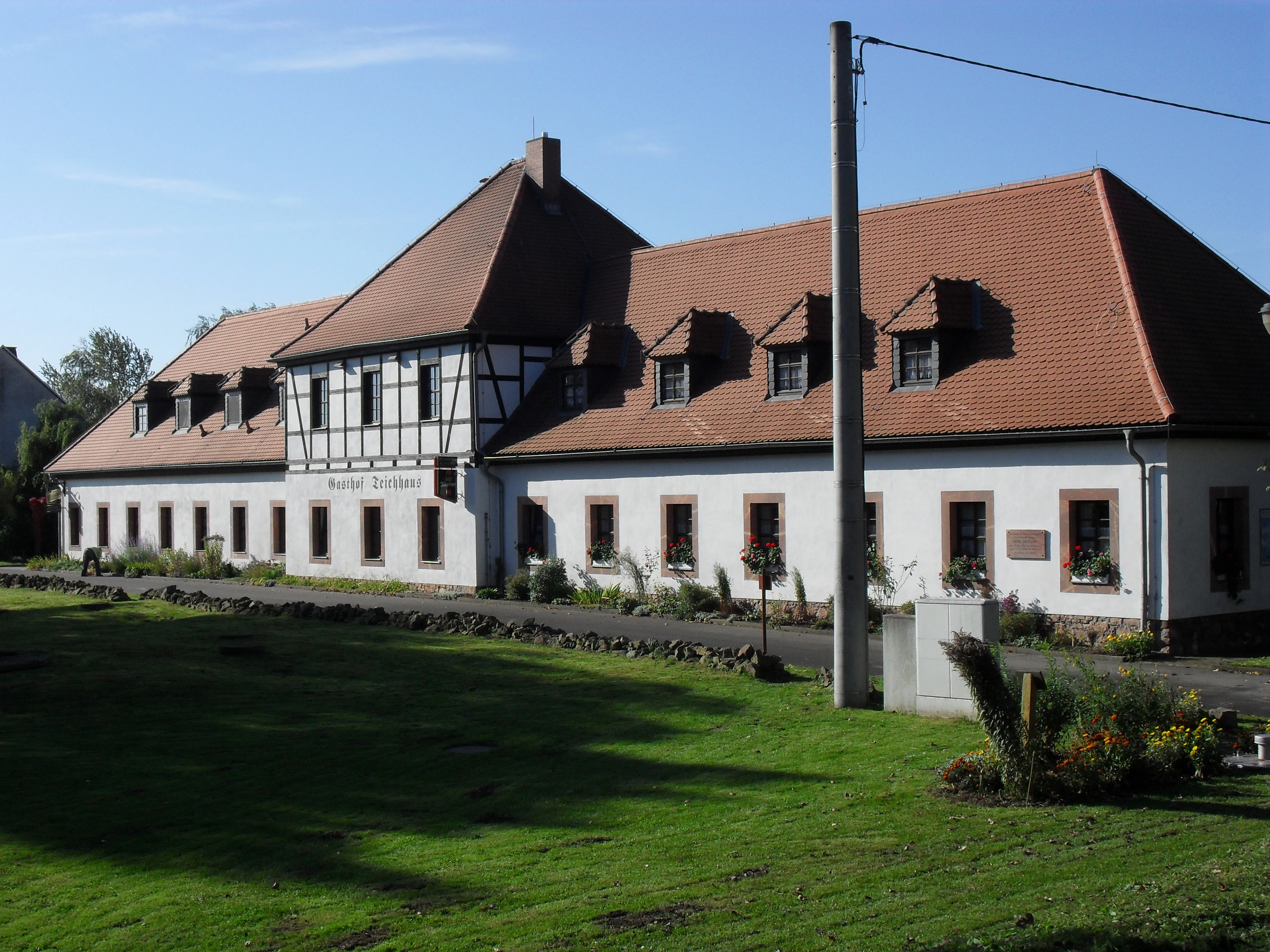
A long, traditional white building with half-timbered accents and a red tiled roof, situated next to a grassy area.
The Teichhaus Frohburg, a nature conservation station and restaurant located within the Eschefelder Teiche nature reserve.

Eschefelder Teiche history and protected-area timeline

The pond system at Eschefeld has its roots in the rural economy of the 18th century, when the local manor estate in Frohburg commissioned the creation of a series of fish-farming ponds. The ponds were designed to support the estate's commercial fisheries, and the associated infrastructure included a four-sided farmstead built around 1780 on the edge of the largest pond. This farmstead became the origin of the small settlement called the Teichhaus, which has retained its historic character and now forms the cultural architectural center of the reserve.

Over the following centuries, the economic focus on fish production gradually diminished, while the natural value of the ponds became increasingly apparent. Migratory and resident waterbirds were drawn to the dependable open water and the surrounding wetland habitats, and the area gained recognition as an important ornithological site. In the late 20th century and into the early 21st century, the area was formally designated as a Naturschutzgebiet, formalizing its role as a protected landscape.

A second chapter in the reserve's modern history involved the degradation of the water supply infrastructure. The pipeline used to pump water from the Wyhra river near Frohburg into the ponds fell into poor condition, leading to falling water levels in the Großteich and reduced breeding success across the pond system. Conservation efforts, including the ongoing presence of the NABU station at the Teichhaus, have focused on managing the reserve in this context of aging infrastructure and shifting ecological priorities.

Eschefelder Teiche landscape and geographic character

The landscape of Eschefelder Teiche is defined by a chain of open water bodies surrounded by low-lying banks, reed belts, and meadows. The largest feature is the Großteich near Eschefeld, whose broad shoreline and artificial dam give the reserve its most recognizable profile. Smaller ponds continue eastward toward Frohburg, creating a varied sequence of water surfaces of different sizes and depths.

Beyond the ponds themselves, the reserve is framed by agricultural land, giving it an island-like quality within an otherwise cultivated Saxon landscape. The contrast between open water, wetland vegetation, and surrounding fields shapes the visual character of the landscape and contributes to its ecological diversity. The historic Teichhaus complex and the dam of the Großteich serve as the main built features, providing both functional infrastructure and recognizable landmarks within the area.

Eschefelder Teiche ecosystems, habitats, and plant life

The reserve's ecological value centers on its wetland habitats and their role in supporting waterbirds. The pond system offers a mosaic of open water, shallow margins, reed stands, and transitional wetland zones that together provide feeding, breeding, and resting habitat for a wide range of species. Because the ponds are artificially maintained, their ecological state is closely tied to water management, which has become a recurring theme in the conservation of the area.

The surrounding farmland plays an indirect but meaningful ecological role, as the open landscape supports many of the bird species that also rely on the ponds for water, safety, and food. The combination of water, wetland vegetation, and adjacent agricultural land defines the broader habitat mosaic of the reserve and gives Eschefelder Teiche its particular character as a working cultural landscape that has become ecologically valuable over time.

Eschefelder Teiche wildlife and species highlights

Waterbirds are the most prominent and ecologically significant wildlife group associated with the reserve. The ponds serve as an important feeding area, a breeding ground, and a stopover site for numerous species, including both resident and migratory waterfowl. The reserve is widely recognized within Saxony for its consistent importance to waterbird populations across the seasons, particularly during migration.

The decline in water levels in the Großteich linked to the deteriorating water pipeline has had visible effects on breeding success in the pond system, underscoring how closely water management and wildlife outcomes are linked here. In addition to waterbirds, the reed and meadow zones around the ponds support a wider community of wetland-associated species, giving the reserve year-round ecological activity despite its relatively modest size.

Eschefelder Teiche conservation status and protection priorities

Conservation at Eschefelder Teiche focuses on maintaining the pond system as viable habitat for waterbird populations and preserving the cultural landscape features that have shaped the area over centuries. The NABU nature conservation station at the Teichhaus coordinates much of the practical work, including monitoring, habitat management, and public engagement.

A persistent conservation challenge is the deteriorating water pipeline that historically carried water from the Wyhra river into the ponds. The resulting low water levels in the Großteich have reduced breeding success, making water infrastructure restoration a central issue for the reserve's long-term ecological health. The protected status of the area as a Naturschutzgebiet provides the legal framework for prioritizing these interventions, while the NABU station provides ongoing operational capacity.

Eschefelder Teiche cultural meaning and human context

The reserve has a clear cultural dimension rooted in the historical fish-farming economy of the Frohburg manor estate. The artificial creation of the ponds in the 18th century, and the construction of the Teichhaus farmstead around 1780, tie the landscape to a specific local heritage of rural estate management and fisheries. The surviving Teichhaus complex remains a tangible link to that earlier economy.

The modern cultural role of the area is closely tied to nature-based engagement. The NABU station at the Teichhaus serves as both a working conservation base and a point of public access, including the on-site inn that anchors the visitor experience. This combination of historical rural infrastructure and contemporary conservation activity gives the reserve a distinctive cultural identity within the Saxony protected-area network.

Top sights and standout views in Eschefelder Teiche

Eschefelder Teiche's strongest points of distinction lie in its identity as a culturally created pond landscape that has become a regionally critical site for waterbirds. The chain of ponds between Frohburg and Eschefeld, the dominant Großteich, and the historic Teichhaus settlement form the core features of the area.

Active on-site conservation through the NABU Teichhaus station, the presence of a dedicated observation shelter on the dam of the Großteich, and the reserve's recognized importance for breeding, feeding, and migratory waterbirds together make Eschefelder Teiche a notable destination for visitors interested in Saxon wetland landscapes and birdwatching.

Best time to visit Eschefelder Teiche

Eschefelder Teiche offers a different character across the seasons, shaped largely by waterbird activity and the open-water conditions of the ponds. Spring and early summer are typically associated with breeding waterbirds and the most active use of reed and shoreline habitats, while autumn brings migratory species using the ponds as staging and resting areas. Winter can be a productive time for observing waterfowl, depending on ice cover.

Because the reserve's value is tied closely to water levels and the condition of the water pipeline, the experience in any given season can reflect the broader state of the pond system. Visitors generally find the most rewarding conditions during periods when open water is widely available and waterbird activity is high, which the NABU station can help interpret through seasonal monitoring efforts.


Monthly climate preview

Long term temperature and precipitation patterns recorded across twelve monthly intervals

Eschefelder Teiche Climate Normals and Representative Monthly Temperature Rhythms

Historical climate data for Eschefelder Teiche documents steady shifts in monthly average temperatures and daily precipitation rates measured from representative coordinates. Reviewing the comprehensive twelve month profile provides a deeper statistical breakdown of long term meteorological trends.
Annual mean9 °C
-1 °C19 °C
Jan-1°
Feb
Mar
Apr
May13°
Jun17°
Jul19°
Aug19°
Sep14°
Oct
Nov
Dec
Warmest month
July

19.1 °C

Coolest month
January

-0.9 °C

Wettest month
July

2.7 mm/day

Driest month
April

1.3 mm/day

Park location guide

Geography guide, regional context, and park location map for Eschefelder Teiche

Eschefelder Teiche park geography, regions, and map view in Germany

Understand where Eschefelder Teiche sits in Germany through a broader geographic reading of the surrounding landscape, nearby location context, and its mapped position within the national park landscape.

How Eschefelder Teiche fits into Germany

Germany is a federal republic in Western and Central Europe with a population of over 83 million across sixteen constituent states. It is Europe's largest economy by nominal GDP and a major global exporter and importer. The capital is Berlin, and the country borders Denmark, Poland, Czech Republic, Austria, Switzerland, France, Luxembourg, Belgium, and the Netherlands.

Wider geography shaping Eschefelder Teiche in Germany

Germany is located in Western and Central Europe, spanning 357,022 km². It borders Denmark to the north, Poland and the Czech Republic to the east, Austria and Switzerland to the south, and France, Luxembourg, Belgium, and the Netherlands to the west. The country has coastlines on the Baltic Sea and North Sea to the north, with the Alps located in the southern region.

Map view of Eschefelder Teiche

Use this park location map to pinpoint Eschefelder Teiche in Germany, understand its exact geographic position, and read its mapped placement within the surrounding landscape more clearly.

Pigeon | © OpenStreetMap contributors

Location context for Eschefelder Teiche

Sachsen
Recorded earthquake history

Review Recorded Earthquake History and Seismic Activity Near Eschefelder Teiche

Consult the historical catalogue of seismic events recorded in the vicinity of Eschefelder Teiche. MoriAtlas provides this data to offer a transparent view of recorded tremor activity and its proximity to the protected pond landscapes of Saxony.

Eschefelder Teiche Earthquake History

Catalogued events

1 event

Strongest magnitude

Magnitude 3

Most recent event

Aug 4, 2006

This history includes earthquakes recorded inside the park or within 50 km of its borders

Explore detailed imagery of historical fish ponds, reed beds, and waterbird habitats.

Eschefelder Teiche Photos and Landscapes: Visual Guide to the Saxon Wetland Reserve

Visual records capture the open water bodies, low banks, and surrounding agricultural farmland that define the protected landscape. Examining these field photographs reveals the wetland terrain and ecological character of the Saxony nature reserve.

A long, traditional white building with half-timbered accents and a red tiled roof, situated next to a grassy area.

A calm, still pond under a clear sky, viewed through trees on the banks.

Park atlas

Compare regional nature reserves and connected wetland habitats across Saxony

Parks Near Eschefelder Teiche: Explore Nearby Protected Areas and Wetland Landscapes

Continue exploring regional conservation areas and wetland ecosystems located near Eschefelder Teiche. Discover adjacent protected landscapes to compare habitat diversity and wildlife distribution across the surrounding district.
A horizontal watercolor painting depicting a soft-focus forest in the foreground and rolling hills in the background.
Nature reserveThuringia
3.5 km away#1 closest

South

Leinawald Nature Reserve: Mapping the Protected Forests and Wetland Habitats of Eastern Thuringia

A comprehensive look at the landscape geography, pond networks, and conservation status of this German woodland.

Leinawald represents a unique confluence of historical forestry, wartime heritage, and ecological recovery within the Altenburger Land region. The area is defined by its loess-mantled ridges and periodic wetland valleys, containing a complex grid of ponds, brooks, and secondary habitats formed in former quartz quarries. Understanding the environmental layers of this site reveals the intersection of natural vegetation potential and 20th century landscape transformation.

Area
18.437 km²
Established
1961
IUCN
IV
Relief
Upland
A horizontal watercolor painting showing a tranquil lake with soft green hills and sparse vegetation along the shoreline under a pale, warm sky.
Nature reserveSachsen
About 6.8 km away#2 closest

North

Bockwitz Nature Reserve: Mapping the Industrial Reclamation Landscapes of Sachsen, Germany

A Protected Mosaic of Rewetted Lakes and Mining Follow-on Terrain

Spanning 545 hectares, the Bockwitz nature reserve offers a unique look at the transformation of former lignite opencast pits into a thriving wetland habitat. The protected area is characterized by its significant residual water bodies, including Bockwitzer See and the Südkippe pit, which showcase the evolution of Sachsen landscape geography following industrial decline. This site serves as a vital example of habitat management within an anthropogenic environment.

Area
5.454 km²
Established
2003
IUCN
IV
Water
Major water bodies
Nature reserveThuringia
About 16 km away#3 closest

West

Phönix Nord Nature Reserve: Mapped Protected Area in the Altenburger Land of Thuringia

A restored post-mining mosaic of heath, scrub, and woodland

Phönix Nord preserves a unique post-mining landscape shaped by historic lignite extraction. This nature reserve in Thuringia features a mosaic of rewilded slopes and reclaimed mineral soils, managed as a vital habitat for native species. Through its distinct topography and conservation efforts, it stands as a key example of industrial renaturation in central Germany.

Area
1.672 km²
Established
2008
IUCN
IV
Relief
Lowland
Nature reserveSaxony
About 18 km away#4 closest

Southeast

Um die Rochsburg Nature Reserve: Geography and Protected River Valley Landscapes in Saxony

A vital riverine conservation zone along the Zwickauer Mulde.

Spanning over 250 hectares, Um die Rochsburg protects the steep, wooded slopes of the Zwickauer Mulde and Brausebach valleys. This nature reserve highlights the regional importance of river-influenced terrain and managed habitat corridors within the Mittelsachsen landscape of Saxony.

Area
2.596 km²
Established
1961
IUCN
IV
A horizontal watercolor illustration showing soft green rolling hills, trees, and a pale yellow sky.
Nature reserveSaxony
About 22 km away#5 closest

Northeast

Alte See, Ruhmberg Nature Reserve: Geographic Atlas of a Protected Landscape in Saxony

Ecological recovery of former military sites in the German lowlands.

Situated in the Landkreis Leipzig, the Alte See, Ruhmberg nature reserve offers a complex study in land use and conservation. The protected area features a unique transition between alder carr wetlands along the Parthe river and the dry, open grasslands of the Ruhmberg hill, creating a high-density biodiversity hotspot within the broader context of Saxon geography.

Area
2.66 km²
Established
2015
IUCN
IV
Protected landscapeThuringia
About 33 km away#6 closest

Southwest

Zaufensgraben Protected Landscape: Geography and Natural Boundaries in Thuringia, Germany

A steep-sided stream valley and protected nature corridor near Gera

Zaufensgraben is a protected landscape corridor centered on a three-kilometer stream valley in Gera, Thuringia. Renowned for its steep gradient within the Weiße Elster system, this area preserves older willow stands and exposes complex Zechstein geology. Its mapped boundaries offer a look at how small-scale protected terrain maintains ecological character within an urbanized historical setting.

Area
0.11 km²
Relief
Upland
Scope
Terrestrial
Water
Minor water
Nature reserveSachsen
About 34 km away#7 closest

East

Scheergrund Nature Reserve: Geographic Atlas and Protected Landscape Overview

Mapping the geology and woodland history of the Leisnig region

Scheergrund functions as a vital nature reserve and geological reference site within the Saxon landscape. This area provides insight into Holocene tufa systems, ancient dam structures, and the complex interplay between spring-fed stream morphology and human development in the Freiberger Mulde tributary valley.

Area
0.578 km²
Established
1961
IUCN
IV
A soft watercolor painting depicting a serene floodplain forest with trees, grasses, and a winding stream, rendered in light green and muted tones.
Nature reserveLeipzig
About 38 km away#8 closest

Northwest

Burgaue Nature Reserve: Alluvial Forest and Hydrological Geography in Leipzig, Germany

Protected floodplain woodland and restored wetland corridors.

Burgaue is a distinctive nature reserve forming the northwestern anchor of the Elster Luppe floodplain. This urban-adjacent protected area preserves a complex topography of historic river channels, wet depressions, and hardwood forest. Through recent hydrological restoration, the landscape maintains its status as a vital riparian habitat and a significant element of the regional Saxon environment.

Area
2.7 km²
Established
1367
Relief
Lowland
Climate
Temperate

Common questions about visiting, size, designation, and location context for Eschefelder Teiche

Eschefelder Teiche FAQs for park facts, access, geography, and protected area context

Find quick answers about Eschefelder Teiche, including protected-area facts, park geography, trail and visitor context, and how the park fits into its surrounding country and regional landscape.
MoriAtlas Explorer

Continue Your Protected Areas Search Across the Global Atlas

Deepen your exploration by continuing the structured search for national parks and protected areas worldwide. Utilize the comprehensive filtering capabilities to compare different conservation landscapes and refine your understanding of global park geography. Discover more about the distribution and characteristics of protected natural areas.

Global natural geography