

Mori Atlas logo
Nature reserveEwens Ponds Conservation Park

A detailed look at the protected limestone aquifers, aquatic habitats, and remnant native ecosystems.

Ewens Ponds Conservation Park: Mapping the Freshwater Spring Systems of South Australia

Ewens Ponds Conservation Park represents a vital protected landscape within South Australia, centered on a series of clear, spring-fed freshwater pools that emerge from porous limestone bedrock. This reserve preserves distinctive aquatic and terrestrial vegetation that has largely disappeared from the surrounding agricultural plains. The site offers significant geographic context for understanding groundwater-fed ecosystems within the Limestone Coast region.

freshwater springslimestone coastgroundwater ecosystemsnative vegetation remnantsaquatic habitatswetland plants

Ewens Ponds Conservation Park

Nature reserve

Park overview

Structured park overview, official facts, and landscape profile for Ewens Ponds Conservation Park

Ewens Ponds Conservation Park park facts, protected area profile, and essential visitor context

Review the core facts for Ewens Ponds Conservation Park, including designation, size, terrain, visitor scale, habitats, and operating context in one park-focused overview.

About Ewens Ponds Conservation Park

Ewens Ponds Conservation Park is a compact but ecologically distinctive reserve in the southeast of South Australia, within the broader Limestone Coast region. Its center of gravity is the chain of freshwater ponds known as the Ewens Ponds, which are fed by groundwater rising through the porous limestone that characterizes much of this part of South Australia. The park protects not only the ponds themselves but also a surrounding buffer of native vegetation in the gazetted locality of Eight Mile Creek, helping to safeguard the land-based habitats that interact with the spring system.

The reserve was established in 1976 under the National Parks and Wildlife Act 1972 with a clear conservation rationale. When proclaimed, it was recognized for protecting remnants of pre-clearing terrestrial and aquatic vegetation communities, for harbouring fauna considered relatively unique within South Australia, and for preserving the physical features of the ponds themselves, which were judged to be unique at a national scale. These founding objectives still shape the park's role today, particularly in a landscape where broadscale agricultural clearing has reduced the extent of native vegetation in the region.

Although it covers only a small footprint, Ewens Ponds Conservation Park has an importance that is out of proportion to its size because the spring system it protects is highly localized and not easily replaced. The ponds, their feeder groundwater, and the surrounding plant communities together form a self-contained ecological unit that distinguishes the park from many of South Australia's larger but more broadly typical national parks. Its IUCN Category III designation reflects this focus on a specific natural feature rather than on a broad landscape-scale ecosystem.

Quick facts and research context for Ewens Ponds Conservation Park

Ewens Ponds Conservation Park is a South Australian protected area located in the gazetted locality of Eight Mile Creek, about 8.4 kilometres east of Port MacDonnell and roughly 25 kilometres south of Mount Gambier. It was proclaimed on 9 September 1976 under the National Parks and Wildlife Act 1972 and is managed by the South Australian Department for Environment and Water. The reserve covers a compact area focused on the Ewens Ponds spring system and adjoining native vegetation, and is classified as an IUCN Category III natural monument or feature.

Protection and recognition

Documented protection records and terrestrial area designation details

Ewens Ponds Conservation Park Protection Status and Management Scope

Ewens Ponds Conservation Park maintains a documented terrestrial protection scope within the regional conservation network. Structured records outline the official status and management framework governing the protected landscape.

Protection details

Protection scope
Terrestrial
Transboundary protection
No
Park context

Deeper park guide and search-rich context for Ewens Ponds Conservation Park

Ewens Ponds Conservation Park history, landscape, wildlife, and travel context

Explore Ewens Ponds Conservation Park through its history, landscape character, ecosystems, wildlife, conservation priorities, cultural context, and seasonal travel timing in a structured park guide built for atlas discovery and search intent.

Why Ewens Ponds Conservation Park stands out

The park is best known for the Ewens Ponds themselves: a series of small, clear, spring-fed freshwater pools that rise from the limestone aquifer of South Australia's Limestone Coast. These ponds are recognized as physically unique within Australia, both for their formation and for the quality of their water, and they support remnant native aquatic and terrestrial vegetation communities that have largely vanished from the surrounding cleared farmland.

Ewens Ponds Conservation Park history and protected-area timeline

Ewens Ponds Conservation Park has a relatively short formal history as a protected area, although the natural spring system it protects has existed for far longer. The land containing the ponds and surrounding native vegetation was formally reserved as a conservation park on 9 September 1976, under the authority of South Australia's National Parks and Wildlife Act 1972, which at the time was the principal legislation governing the creation and management of protected areas in the state.

The proclamation was driven by a specific conservation case. By the mid 1970s, much of the surrounding landscape in the Limestone Coast had been cleared for agricultural development, and the native terrestrial and aquatic vegetation communities associated with the Ewens Ponds spring system had been reduced to scattered remnants. The ponds themselves were also recognized as physically unique within Australia. Motivated by these considerations, the South Australian government set aside the ponds and a parcel of adjoining land to keep these features intact, framing the park around the protection of vegetation remnants, associated fauna, and the distinctive hydrological system.

Since its creation, the conservation park has remained under state management, today administered through the Department for Environment and Water. Its IUCN Category III classification, applied to natural monuments or features, reflects the lasting emphasis on the ponds themselves as the defining reason for the reserve's existence, rather than on a broader wilderness or landscape-scale protection goal.

Ewens Ponds Conservation Park landscape and geographic character

The landscape of Ewens Ponds Conservation Park is defined primarily by its freshwater spring system rather than by dramatic topography. The ponds are shallow pools of clear, cool water that emerge from the limestone aquifer of South Australia's Limestone Coast, one of the region's defining geological features. The water rises through porous limestone bedrock and surfaces as a chain of small, closely connected ponds that together create a distinctive aquatic setting within the park.

Surrounding the ponds, the terrestrial environment reflects the same limestone-influenced ecology that characterizes much of the southeast of South Australia. Native vegetation remnants, including both terrestrial and aquatic plant communities, line the watercourses and fringes of the ponds. The broader topography is comparatively gentle, with the spring system sitting within modestly undulating countryside that has, in many surrounding areas, been converted to farmland. Within the park boundaries, however, the natural landforms and vegetation patterns remain visibly intact, providing a contrast with the cleared land that extends outside the reserve.

Ewens Ponds Conservation Park ecosystems, habitats, and plant life

Ecologically, Ewens Ponds Conservation Park is built around two closely linked habitat types: the spring-fed pond system itself and the native terrestrial vegetation that surrounds it. The ponds create a freshwater aquatic environment that is fed year-round by groundwater, producing relatively stable water conditions that have allowed specialized aquatic plant communities to persist. These aquatic communities are among the key ecological features the park was established to protect, because they represent remnants of vegetation that once extended more widely across the region.

On land, the reserve preserves remnants of the terrestrial vegetation communities that existed in the area prior to the agricultural clearing that transformed much of the surrounding Limestone Coast landscape. Together, the aquatic and terrestrial plant communities form an interconnected ecological unit, with the riparian and fringing vegetation of the ponds blending into broader native plant cover on the adjoining land within the Eight Mile Creek locality. The result is a small but unusually coherent example of native vegetation patterns that have largely been lost elsewhere in the district.

Ewens Ponds Conservation Park wildlife and species highlights

The wildlife values of Ewens Ponds Conservation Park are closely tied to the habitats protected within and around the ponds. When the park was proclaimed, its fauna was described as relatively unique within South Australia, reflecting the unusual combination of aquatic and terrestrial environments combined in such a small area. The spring-fed ponds and their associated vegetation support animal communities adapted to cool, clear freshwater and to the native plant cover that continues along the pond margins.

The surrounding terrestrial vegetation remnants also provide habitat for native fauna that depend on the native plant communities that have been retained within the reserve. Although the park's small footprint limits the overall abundance of wildlife it can support, the persistence of relatively undisturbed native vegetation in an otherwise heavily modified landscape gives the reserve a disproportionate significance for fauna conservation in the local region.

Ewens Ponds Conservation Park conservation status and protection priorities

From a conservation perspective, Ewens Ponds Conservation Park is significant out of proportion to its small size because the features it protects are narrowly localized and easily lost. The spring system itself is physically unique within Australia, and the native terrestrial and aquatic plant communities associated with it have become increasingly rare in the broader Limestone Coast landscape, where clearing for agriculture has reduced native vegetation to scattered remnants.

The park's IUCN Category III designation underlines this focus: it is protected specifically as a natural monument or feature rather than as a broad wilderness area. This designation reflects the view that the ponds, and the vegetation and fauna tied to them, warrant targeted protection on their own merits. By maintaining an intact buffer of native vegetation around the ponds, the reserve also helps preserve water quality, hydrological function, and habitat continuity for the species that depend on the spring system, giving it a continuing conservation role well beyond its proclaimed boundaries.

Top sights and standout views in Ewens Ponds Conservation Park

The standout feature of Ewens Ponds Conservation Park is the spring-fed pond system itself, with its clear, cool water rising from limestone geology and supporting native aquatic plant communities that have largely disappeared from the surrounding region. Equally important is the surrounding buffer of native terrestrial vegetation, which gives the reserve ecological coherence and contrasts with the cleared farmland that characterizes much of the nearby Limestone Coast. Together, these elements make a small reserve that punches well above its weight in terms of ecological distinctiveness.
Monthly climate preview

Long-term representative temperature and precipitation averages by month

Ewens Ponds Conservation Park Climate Normals and Annual Weather Patterns

Representative coordinates record measured monthly temperature swings from 11.02 degrees Celsius to 18.03 degrees Celsius alongside shifting precipitation totals. Examining the complete twelve-month profile reveals detailed baseline climate rhythms across the protected area.
Annual mean14 °C
11 °C18 °C
Jan18°
Feb18°
Mar17°
Apr15°
May13°
Jun12°
Jul11°
Aug11°
Sep12°
Oct13°
Nov15°
Dec16°
Warmest month
February

18 °C

Coolest month
July

11 °C

Wettest month
July

3.1 mm/day

Driest month
February

0.9 mm/day

Park location guide

Geography guide, regional context, and park location map for Ewens Ponds Conservation Park

Ewens Ponds Conservation Park park geography, regions, and map view in Australia

Understand where Ewens Ponds Conservation Park sits in Australia through a broader geographic reading of the surrounding landscape, nearby location context, and its mapped position within the national park landscape.

How Ewens Ponds Conservation Park fits into Australia

Australia is a constitutional monarchy and federal parliamentary democracy comprising six states and ten territories. With a population of nearly 28 million, it is one of the world's most urbanised countries, with most people concentrated on the eastern seaboard. The country has a high Human Development Index and is known for its cultural diversity, ancient Aboriginal heritage, and unique wildlife.

Wider geography shaping Ewens Ponds Conservation Park in Australia

Australia occupies the entire Australian continent, the island of Tasmania, and numerous smaller islands. It is the world's flattest and driest inhabited continent, featuring vast deserts in the interior (the Outback), tropical rainforests along the eastern coast, and a coastline bordering the Indian and Pacific Oceans.

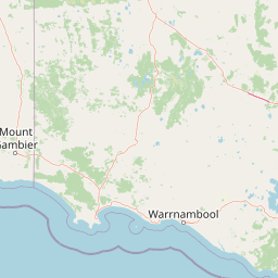
Map view of Ewens Ponds Conservation Park

Use this park location map to pinpoint Ewens Ponds Conservation Park in Australia, understand its exact geographic position, and read its mapped placement within the surrounding landscape more clearly.

Pigeon | © OpenStreetMap contributors

Location context for Ewens Ponds Conservation Park

South Australia
Recorded earthquake history

Browse the Historical Earthquake Record for Ewens Ponds Conservation Park

Examine a verified collection of recorded seismic events located near Ewens Ponds Conservation Park. MoriAtlas provides these historical data points to help researchers and observers trace earthquake activity patterns within the Limestone Coast region of South Australia.

Ewens Ponds Conservation Park Earthquake History

Catalogued events

2 events

Strongest magnitude

Magnitude 3.6

Most recent event

Jan 5, 2002

This history includes earthquakes recorded inside the park or within 50 km of its borders

Park atlas

Compare adjacent wetland reserves and limestone coast habitats in South Australia

Parks Near Ewens Ponds Conservation Park And Surrounding Regional Protected Areas

Browse other protected areas and groundwater ecosystems located near Ewens Ponds Conservation Park. Expanding the geographic comparison helps trace similar freshwater spring complexes across the surrounding region.
Nature reserveSouth Australia
About 9.2 km away#1 closest

West

Dingley Dell Conservation Park Protected Area and Geographic Overview

Limestone Coast woodland and heritage landscape

Dingley Dell Conservation Park is a compact protected area situated in the south-east of South Australia, near Port MacDonnell. The site features a preserved woodland landscape dominated by blue gums and wattles, offering a quiet, sheltered contrast to the surrounding pastoral paddocks of the Limestone Coast. This overview examines the geography, boundaries, and historical significance of the reserve as a unique, small-scale protected land entity.

Area
0.06 km²
Established
1922
Relief
Lowland
Climate
Mediterranean
National parkAustralia
15 km away#2 closest

East

Lower Glenelg National Park: Dramatic River Gorge and Limestone Cave Protected Landscape

Explore its mapped boundaries and unique geological features.

Lower Glenelg National Park in Victoria, Australia, is a national park celebrated for its visually stunning Glenelg River gorge. This protected area showcases millions of years of geological history etched into its limestone cliffs and features the accessible Princess Margaret Rose Cave. Understand the park's mapped landscape, its diverse terrain from riverine woodlands to coastal wetlands, and its significance within regional geographic exploration.

Area
273 km²
Established
1969
IUCN
II
Visitors
200K annual
Nature reserveSouth Australia
17 km away#3 closest

West

Douglas Point Conservation Park: Coastal Protected Area and Limestone Geography

Nature reserve atlas entry for southeastern South Australia.

Douglas Point Conservation Park serves as a crucial refuge for endangered flora along the Limestone Coast. This nature reserve highlights the intersection of coastal limestone formations and specific biodiversity conservation goals, providing a clear example of South Australia's targeted approach to regional protected lands and specialized shoreline ecosystems.

Area
0.6 km²
Established
1997
IUCN
VI
Relief
Lowland
Nature reserveSouth Australia
34 km away#4 closest

West

Carpenter Rocks Conservation Park: Geography and Protected Woodland Map in South Australia

A specialized nature reserve supporting endemic plant and bird habitats

Discover the geographic footprint of Carpenter Rocks Conservation Park in the Limestone Coast region of South Australia. This nature reserve is defined by its role in preserving the only known population of the Carpenter Rocks Manna Gum and its status as a historical sanctuary for threatened migratory bird populations.

Area
0.33 km²
Established
2001
IUCN
VI
Visitors
100 annual
National parkSouth Australia
36 km away#5 closest

Northwest

Canunda National Park: South Australia's Protected Landscape and Geographic Atlas

Explore mapped boundaries and regional natural geography.

Canunda National Park in South Australia is presented here as a distinct protected landscape. This detail page focuses on its geographic setting, providing insights into its mapped boundaries and its role within the regional atlas context. Understand the park's natural geography and its protected status for informed exploration.

Area
96.24 km²
Established
1959
IUCN
VI
Relief
Lowland
Nature reserveSouth Australia
About 41 km away#6 closest

Northwest

Gower Conservation Park: A Protected Eucalypt Forest Reserve in South Australia

Mapped terrain, calcarenite dunes, and native woodland ecosystems

Gower Conservation Park preserves a representative stand of native eucalypt forest on a backdrop of ancient, consolidated calcarenite dunes. Located in the lower south east of South Australia, the area stands as a significant ecological remnant featuring stringybark woodlands, limestone outcrops, and diverse understorey vegetation that reflect the historic character of the surrounding regional geography.

Area
0.4 km²
Established
1971
IUCN
III
Relief
Upland
National parkBarwon South West
45 km away#7 closest

East

Cobboboonee National Park: A Protected Landscape in Australia's Barwon South West Region

Explore its mapped geography and natural terrain.

Cobboboonee National Park represents an important protected area within the Barwon South West region of Australia. This destination offers users a deep dive into the park's specific geography, providing context on its mapped boundaries and the surrounding natural landscapes. It is designed for exploration of the park's protected-area identity and its place within the regional geography, offering structured data for landscape context.

Area
185.1 km²
Established
2008
IUCN
II
Climate
Temperate
National parkAustralia
57 km away#8 closest

Southeast

Discovery Bay Marine National Park: Victoria's Protected Coastal Marine Landscape

Mapped protected waters adjacent to Cape Bridgewater's unique geography.

Discover the geographic scope and protected landscape identity of Discovery Bay Marine National Park, an important marine national park located in Victoria, Australia, near Portland. This protected area safeguards a crucial stretch of the country's southern coastline, contributing to the ecological significance of the Southern Ocean marine region. Its position adjacent to the Discovery Bay Coastal Park highlights an integrated conservation approach, offering users a detailed view of its mapped marine boundaries and the distinctive geological context of the Cape Bridgewater area for atlas exploration.

Area
27.7 km²
Established
2002
IUCN
II
Climate
Temperate

Common questions about visiting, size, designation, and location context for Ewens Ponds Conservation Park

Ewens Ponds Conservation Park FAQs for park facts, access, geography, and protected area context

Find quick answers about Ewens Ponds Conservation Park, including protected-area facts, park geography, trail and visitor context, and how the park fits into its surrounding country and regional landscape.
MoriAtlas Explorer

Continue Your Protected Areas Search Across the Global Atlas

Deepen your exploration by continuing the structured search for national parks and protected areas worldwide. Utilize the comprehensive filtering capabilities to compare different conservation landscapes and refine your understanding of global park geography. Discover more about the distribution and characteristics of protected natural areas.

Global natural geography