
Mori Atlas logo
Nature reserveFaulbruch von Münster

A detailed atlas examination of alder swamp forests, wet meadows, and protected lowland terrain.

Faulbruch von Münster Nature Reserve: Geographic Mapping of Hessen Wetland Landscapes

(Naturschutzgebiet Faulbruch bei Münster)

Faulbruch von Münster represents a significant nature reserve within the Hessen region of Germany, characterized by low-lying waterlogged terrain and Pliocene clay soils. This protected area supports a complex mosaic of alder swamp forest, moist meadows, and open water features. Explore the geographic boundaries and ecological structure that define this rare lowland habitat.

wetlandswamp forestalder woodlandnature reserveNaturschutzgebietlowland forest
A flat-design illustration of a forest landscape with tall trees in the foreground, a stream winding through the center, and a distant waterfall cascading over rocky cliffs.

Faulbruch von Münster

Nature reserve

Park overview

Structured park overview, official facts, and landscape profile for Faulbruch von Münster

Faulbruch von Münster park facts, protected area profile, and essential visitor context

Review the core facts for Faulbruch von Münster, including designation, size, terrain, visitor scale, habitats, and operating context in one park-focused overview.

About Faulbruch von Münster

Faulbruch von Münster is one of many smaller, ecologically focused nature reserves in the Darmstadt-Dieburg district of southern Hesse, but it stands out for the density and quality of its wetland habitats within a relatively small footprint. It lies in the transitional zone between the Untermainebene and the Gersprenz lowlands and the gently rolling Messeler Hügelland, on the western edge of the village of Münster, and is bordered by the B 45 federal road to the east and local roads to the north and south.

The reserve protects a landscape that has been shaped over centuries by human activity. Originally covered by forest, much of the area was cleared in the late nineteenth century, drained with a network of ditches, and converted to fields and meadows. After reforestation efforts began in 1945, woodland expanded again and today dominates the site. The current mosaic includes about 65 percent forest, roughly 21 percent grassland, and smaller portions of arable land and open water, including a small pond, the Gänsweiher, in the western part of the forest.

Ecologically, the most distinctive features are the alder swamp forest on the wettest soils and the mosaic of moist and intermittently wet meadows around it. These habitats support a large number of plant species, including several that are considered rare or threatened in Hesse, and form the basis for an equally diverse fauna. Because the reserve integrates forest, meadow, and aquatic habitats so tightly, it functions less as a single habitat and more as a small wetland ecosystem that is heavily influenced by groundwater and former drainage patterns.

Quick facts and research context for Faulbruch von Münster

Faulbruch von Münster is a nature reserve in southern Hesse, Germany, located on the western edge of the village of Münster in the Darmstadt-Dieburg district. The protected area covers around 77 hectares at an elevation of roughly 134 to 143 meters above sea level, on wet Pliocene clay soils.

Designated in 1985 and extended in 1993, it is classified under the German Naturschutzgebiet framework with identification number 1432011 and corresponds to IUCN Category IV. Roughly 65 percent of the area is forest, with the remainder made up of meadows, fields, and a small pond, creating a habitat-rich mosaic of wetland and woodland environments.

Protection and recognition

Examine official protected area records and international recognition entries.

Faulbruch von Münster Protection Status and Official Designation Data

Faulbruch von Münster holds documented conservation records detailing formal protected area status and administrative oversight frameworks. Systematic atlas data aggregates verified international recognition sources alongside baseline database tracking metrics.

Protection details

WDPA ID
344584
Park context

Deeper park guide and search-rich context for Faulbruch von Münster

Faulbruch von Münster history, landscape, wildlife, and travel context

Explore Faulbruch von Münster through its history, landscape character, ecosystems, wildlife, conservation priorities, cultural context, and seasonal travel timing in a structured park guide built for atlas discovery and search intent.

Why Faulbruch von Münster stands out

The reserve is best known for its alder swamp forest (Erlenbruchwald), a wetland forest community that has become rare in the lowlands of Hesse. Together with surrounding meadows on permanently moist soils, this swamp forest forms the core of the protected area's identity and ecological value. It is also recognized for the unusually high plant diversity that has been documented on a relatively small area, including floodplain meadow types and relict woodland communities shaped by centuries of agricultural drainage and subsequent reforestation. The combination of damp grassland, swamp forest, and a small pond creates a compact but ecologically rich wetland landscape in an otherwise densely settled part of the Rhine-Main region.
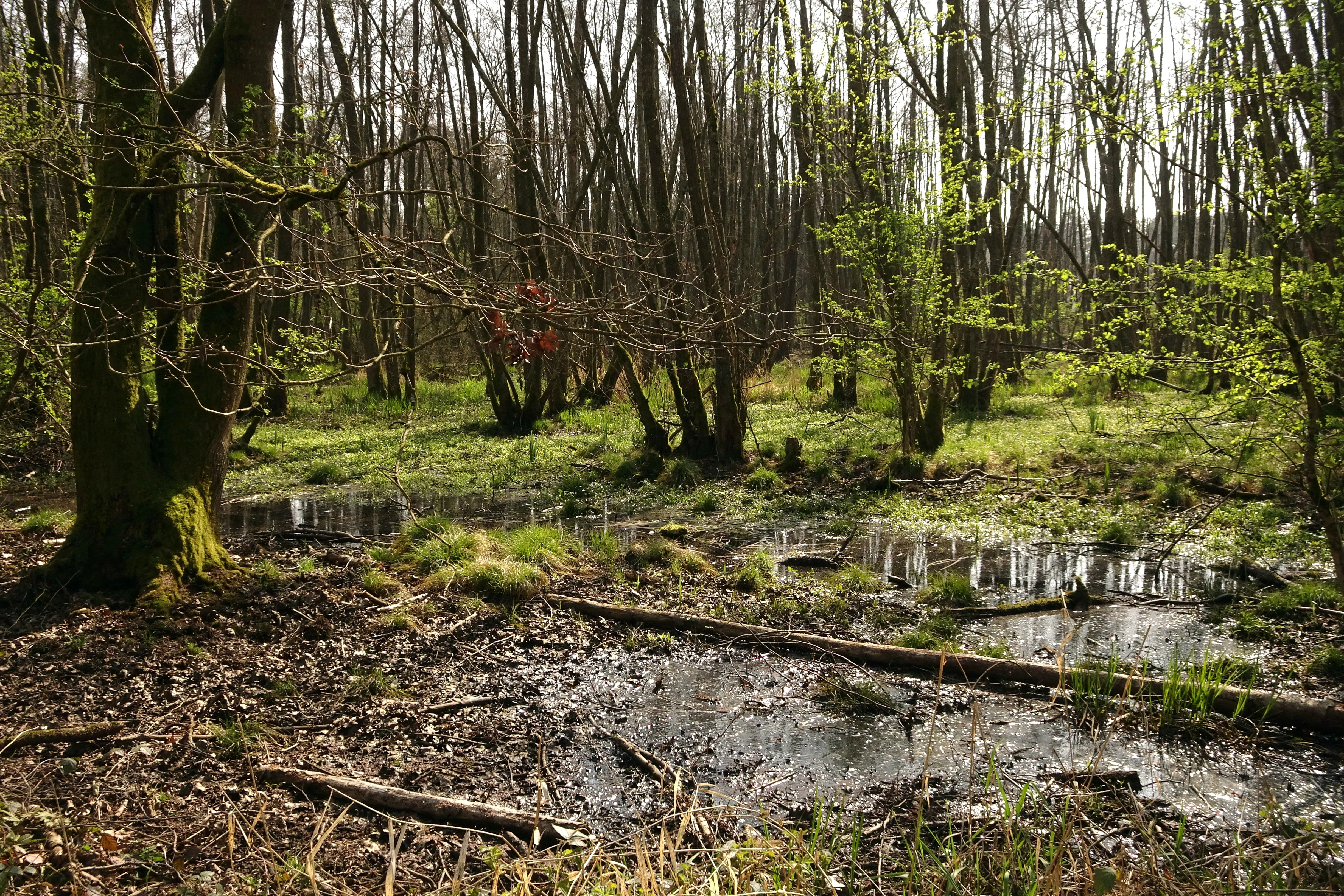
A swamp forest with standing water, fallen logs, and young green foliage on trees, representing a wet woodland ecosystem.
A view of the wetland forest habitat at Faulbruch von Münster during spring.

Faulbruch von Münster history and protected-area timeline

The historical development of Faulbruch is closely tied to how land was used and then partially restored. The natural wetland forest that originally covered much of the site was significantly altered by human intervention starting in the late nineteenth century, when roughly half of the forest was cleared, an extensive network of drainage ditches was dug, and the freed land was turned into fields and meadows.

This agricultural intensification shaped the landscape that exists today. From 1945 onward, the trend began to reverse through systematic reforestation, which gradually restored woodland cover. The state of Hesse formally recognized the ecological value of the area when it designated the site as a nature reserve (Naturschutzgebiet) by decree on 17 October 1985, under identification number 1432011.

The reserve's boundaries were adjusted and slightly expanded on 20 September 1993 to refine protection of the surrounding meadows and forest communities. Inscribed in the World Database on Protected Areas as entry 344584 and classified as an IUCN Category IV area, the site is now managed primarily as a habitat and species management zone, reflecting both its conservation significance and the need to manage the legacy of past drainage and cultivation.

Faulbruch von Münster landscape and geographic character

The landscape of Faulbruch von Münster is a low-lying, mostly flat wetland scene set at only modest elevations of 134 to 143 meters above sea level. Its surface is shaped by underlying Pliocene clay layers, which hold water near the surface and create the conditions that give the reserve its swampy character.

The terrain is a mosaic of woodland blocks, meadow strips, fields, and small open water. A small pond, the Gänsweiher, lies within the forest in the western part of the area and adds a distinctive open-water element to an otherwise wooded site. The reserve is bounded to the east by the B 45 federal road, to the south by the Munastraße, and to the north by a forest track known as the Russenschneise, while the locality of Breitefeld sits at its southwestern edge.

The wet soils, combined with the gentle transitions between forest, meadow, and former cropland, give the area a quiet, enclosed character typical of lowland wetland reserves. Although the relief is minimal, the subtle shifts between drier elevated ground and waterlogged depressions create the structural variety that supports the area's botanical and ecological richness.

Faulbruch von Münster ecosystems, habitats, and plant life

The ecological identity of Faulbruch is rooted in the interaction between wet soils and the land-use history described above. The forests on the wettest sites are alder-dominated swamp forests (Erlenbruchwald), often combined with tall sedges, while slightly drier positions support beech forest communities. This small-scale alternation between very wet and somewhat drier forest habitats is one of the defining features of the area.

The open habitats are equally important. The meadows include large-sedge communities (Großseggengesellschaften), moist Sanguisorba-Festuca floodplain meadows, and more intermittently wet oat-grass meadows (Glatthaferwiesen). On areas of former grassland that have been left to succeed, moor grass (Pfeifengras) becomes dominant, signaling the strong influence of groundwater. Overall, more than 270 plant species have been documented in this relatively compact reserve, including 15 species listed on German Red Lists.

This habitat mosaic also supports a wide variety of animal groups. The combination of swamp forest, wet meadow, and a small standing water body provides shelter, food, and breeding sites for amphibians, reptiles, breeding birds, and insects, while the broader connectivity with surrounding countryside allows larger mammals to use the area as part of a wider rural habitat network.

Faulbruch von Münster wildlife and species highlights

Faulbruch is unusually rich in wildlife for an area of its size, reflecting the diversity and quality of its habitats. Among mammals, the reserve supports species such as the European badger, water shrew, and several bat species, including the common noctule and the mouse-eared bat. The forest-meadow mosaic provides these animals with both foraging grounds and quiet refuge in an otherwise heavily used part of southern Hesse.

The wet habitats are particularly important for amphibians and reptiles. Fourteen amphibian and reptile species from the regional Red Lists have been recorded, using the combination of wet woodland, damp meadows, and the small Gänsweiher pond. In terms of birds, the reserve is documented as the breeding and feeding habitat of 75 bird species, 14 of which are considered threatened in regional assessments, indicating that the area functions as a meaningful breeding ground within the local landscape.

Insect diversity is also notable. Species documented in the area include the swallowtail butterfly, the greater water beetle, and the rhinoceros beetle, among many others. Together, these groups illustrate how the reserve supports a wildlife community far richer than its modest size alone would suggest, and how the maintenance of wet conditions is central to that richness.

Faulbruch von Münster conservation status and protection priorities

As a designated Naturschutzgebiet under Hessian law and a corresponding IUCN Category IV area, Faulbruch is managed primarily to conserve and develop the habitat types and species that depend on its wet soils. Its main conservation objective is to maintain and improve both the grassland cultural landscape and the surrounding forest communities, with particular emphasis on the alder swamp forest, which has become uncommon in the cultivated lowlands of the region.

The reserve's conservation significance lies in how much ecological value is concentrated within a small, semi-rural setting. The combination of alder swamp forest, wet meadows, and small standing water provides conditions for a wide range of plants, amphibians, birds, and invertebrates, including many species of conservation concern. The reserve also functions as a refuge and stepping stone within the broader agricultural and suburban landscape of the Darmstadt-Dieburg district.

Management challenges include the legacy of nineteenth-century drainage, which continues to influence water tables and vegetation patterns, and recurring incidents of illegal dumping that have required costly cleanup. Combating these pressures, alongside ongoing habitat management aimed at preserving the meadow-forest transitions that define the area, is central to maintaining the reserve's ecological value over time.

Faulbruch von Münster cultural meaning and human context

The cultural dimension of Faulbruch is inseparable from its ecological landscape. The mosaic of meadows, fields, and forest fragments is the result of centuries of human shaping, particularly the late nineteenth-century clearance and drainage that converted much of the original woodland into farmland. The subsequent reforestation from 1945 onward reflects another important shift in regional land use, as former cropland was returned to forest.

The reserve also sits within a regionally significant cultural landscape of southern Hesse, close to the village of Münster and the locality of Breitefeld. Traditional landscape names such as Faulbruch, Russenschneise, and Munastraße reflect long-standing local land use and illustrate how the area has long been embedded in everyday rural life, even as it has acquired formal ecological protection status.

Top sights and standout views in Faulbruch von Münster

The most distinctive features of Faulbruch von Münster are its alder swamp forest, its tightly interwoven patches of wet meadow and woodland, and the surprising density of species documented within a relatively small reserve. The presence of a small pond, the Gänsweiher, inside an otherwise continuous forest block adds a particularly striking habitat transition.

The reserve also stands out for the breadth of its Red List records across plants, amphibians, reptiles, breeding birds, and insects, demonstrating that even small, low-elevation protected areas can have substantial regional conservation significance when their habitats are well preserved.

Best time to visit Faulbruch von Münster

Spring is particularly rewarding in Faulbruch von Münster, when the moist meadows come into growth and the varied plant communities across the wet grassland become most visible. Early mornings in spring are also the most active period for many of the breeding bird species recorded here.

Late spring and early summer bring out the full development of the meadow flora and offer good conditions for observing amphibian activity around the small pond and wet forest edges. Late summer and early autumn highlight the contrast between the tall-sedge and grass communities on the meadows and the increasingly dense canopy of the alder and beech forest, while the cooler, damper atmosphere of the swamp forest remains a defining feature of the site year-round.

Monthly climate preview

Long-term temperature and precipitation records measured across a representative coordinate

Faulbruch von Münster Climate Normals and Annual Weather by Month

Representative coordinates document twelve-month temperature variation and daily precipitation averages for Faulbruch von Münster based on historical climate normals. Reviewing the complete monthly profile provides essential analytical depth for understanding long-term environmental patterns across the protected terrain.
Annual mean10 °C
0 °C21 °C
Jan
Feb
Mar
Apr10°
May14°
Jun18°
Jul21°
Aug20°
Sep15°
Oct10°
Nov
Dec
Warmest month
July

20.6 °C

Coolest month
January

0.2 °C

Wettest month
July

2.2 mm/day

Driest month
April

1.4 mm/day

Park location guide

Geography guide, regional context, and park location map for Faulbruch von Münster

Faulbruch von Münster park geography, regions, and map view in Germany

Understand where Faulbruch von Münster sits in Germany through a broader geographic reading of the surrounding landscape, nearby location context, and its mapped position within the national park landscape.

How Faulbruch von Münster fits into Germany

Germany is a federal republic in Western and Central Europe with a population of over 83 million across sixteen constituent states. It is Europe's largest economy by nominal GDP and a major global exporter and importer. The capital is Berlin, and the country borders Denmark, Poland, Czech Republic, Austria, Switzerland, France, Luxembourg, Belgium, and the Netherlands.

Wider geography shaping Faulbruch von Münster in Germany

Germany is located in Western and Central Europe, spanning 357,022 km². It borders Denmark to the north, Poland and the Czech Republic to the east, Austria and Switzerland to the south, and France, Luxembourg, Belgium, and the Netherlands to the west. The country has coastlines on the Baltic Sea and North Sea to the north, with the Alps located in the southern region.

Map view of Faulbruch von Münster

Use this park location map to pinpoint Faulbruch von Münster in Germany, understand its exact geographic position, and read its mapped placement within the surrounding landscape more clearly.

Pigeon | © OpenStreetMap contributors

Location context for Faulbruch von Münster

Hessen

Visual exploration of swamp forests, moist meadows, and low-lying terrain character

Faulbruch von Münster Photos, Landscape Scenery, and Protected Wetland Habitat Views

Visual records capture the low-lying wetland terrain, rare alder swamp forests, and interwoven moist meadows of Faulbruch von Münster. Examining these protected-area photographs reveals the structural environmental details and natural habitat mosaic that define the reserve.

A swamp forest with standing water, fallen logs, and young green foliage on trees, representing a wet woodland ecosystem.

A swamp forest with numerous tree trunks emerging from still, shallow water and wet ground, featuring patches of green grasses and dappled sunlight filtering through the trees.

Park atlas

Compare adjacent wetland reserves, lowland forests, and regional conservation landscapes.

Parks Near Faulbruch von Münster and Surrounding Protected Natural Areas

Browse other protected areas located near Faulbruch von Münster to compare regional wetland habitats and lowland forest ecosystems. Expanding the geographic scope reveals connected conservation landscapes across southern Hesse and surrounding terrain.
Watercolor painting of a soft, hazy landscape featuring scattered trees, bushes, and rolling hills in shades of green and pink against a pale background.
Nature reserveHesse
About 1.5 km away#1 closest

South

Fohlenweide von Dieburg: Nature Reserve and Protected Landscape in Hesse, Germany

Mapping the wet meadow habitats and ecological boundaries of southern Hesse.

Located in the Darmstadt-Dieburg district, Fohlenweide von Dieburg is a refined example of a small-scale cultural landscape preserved for its high ecological value. The protected area features a unique mosaic of damp grasslands, forest margins, and riparian strips that support a range of wildlife. This site offers insight into regional conservation management in Central Europe.

Area
0.235 km²
Established
1989
IUCN
IV
Relief
Lowland
A soft watercolor illustration depicting a calm wetland scene with distant rolling hills, foreground reeds, and overhanging tree branches.
Nature reserveHesse
About 2 km away#2 closest

Northwest

Rallenteich von Eppertshausen Nature Reserve: Protected Landscape and Regional Geography

Wetland and forest mosaic in the Hesse region

Examine the geographic footprint of Rallenteich von Eppertshausen, a significant nature reserve in Hesse, Germany. This 12-hectare protected area showcases a dense mosaic of pond, reedbed, and acidic oak forest that evolved from historical clay mining. Understanding the park's topography and internal landscape zones offers insight into the evolution of post-industrial protected lands.

Area
0.12 km²
Established
1976
IUCN
IV
Relief
Lowland
Nature reserveHessen
About 2.7 km away#3 closest

Northwest

Erlenwiesen bei Ober-Roden Nature Reserve: Landscape and Geography in Hessen, Germany

Protected riparian forest and wetland habitat mosaic

Erlenwiesen bei Ober-Roden is a specialized nature reserve in the Messeler Hügelland of Hessen, protecting a dense concentration of alder-ash floodplain forests, sedge swamps, and wet meadows. Spanning approximately 14 hectares, it remains a crucial example of lowland stream valley conservation and habitat management within the German landscape.

Area
0.143 km²
Established
1996
IUCN
IV
A horizontal watercolor painting depicting a soft-focus landscape with rolling green hills, a marshy foreground with grasses, and light purple mountains in the distance.
Nature reserveHesse
About 3.2 km away#4 closest

South

Das große Hörmes bei Dieburg Nature Reserve: A Wetland Protected Area in Hesse

Mapped lowland wetland habitat in the Gersprenz district

This compact nature reserve in southern Hesse provides a essential sanctuary for wetland species, featuring a rare combination of reedbeds, sedge stands, and moist litter meadows. The area highlights the historical character of the Gersprenz lowlands through its protected hydrological network and open herbaceous habitat structure.

Area
0.136 km²
Established
1985
IUCN
IV
A soft watercolor illustration depicting a meadow landscape with a winding stream, distant hills, and foreground wildflowers.
Nature reserveHessen
About 3.4 km away#5 closest

East

Die kleine Qualle von Hergershausen Nature Reserve and Protected Floodplain Landscapes

A preserved wetland fragment in the Hessen region

Die kleine Qualle von Hergershausen stands as a key protected area within the Gersprenz floodplain. This site offers a unique look at remnant wet meadow terrain, serving as an essential breeding and stopover ground for waterbirds in the Darmstadt-Dieburg district. Its geography provides a clear contrast to the surrounding agricultural fields, highlighting the impact of long-term conservation and habitat restoration efforts.

Area
0.27 km²
Established
1984
IUCN
IV
A horizontal watercolor illustration depicting a soft, pastel-colored meadow with wildflowers in the foreground and a gentle forest line in the background against a white background.
Nature reserveLandkreis Darmstadt-Dieburg
About 3.7 km away#6 closest

West

Neuwiese von Messel Nature Reserve: Mapped Geography and Protected Landscape Context

Essential nature reserve located in Landkreis Darmstadt-Dieburg

Neuwiese von Messel consists of open meadow islands surrounded by mature deciduous forest, creating a representative forest-meadow mosaic in the Messeler Hügelland. This nature reserve functions as a vital conservation site for specialized plants and habitat types, protected within the European Natura 2000 network. Gain insight into its terrain, soil-based biodiversity, and the centuries-old traditional management that sustains this protected German landscape.

Area
1.072 km²
Established
1986
IUCN
IV
Relief
Lowland
A horizontal watercolor painting depicting a soft-focus landscape with green fields, patches of wildflowers, and distant low hills.
Nature reserveHessen
About 3.9 km away#7 closest

East

Auf dem Sand zwischen Hergershausen und Altheim Protected Nature Reserve in Hessen

Inland dune and floodplain landscape mapping

Explore the geography of Auf dem Sand zwischen Hergershausen und Altheim, a nature reserve in Hessen. The area serves as a critical habitat mosaic, featuring sandy inland dunes, expansive wet grasslands, and renaturalized floodplain terrain within the Gersprenz valley.

Area
0.233 km²
Established
1998
IUCN
IV
Watercolor painting of a soft landscape showing a light orange foreground, a band of green trees and bushes in the midground, and faint rolling hills against a pale yellow sky in the background.
Nature reserveLandkreis Darmstadt-Dieburg
About 5.1 km away#8 closest

Northeast

Brackenbruch bei Hergershausen: Nature Reserve and Floodplain Ecosystem in Darmstadt-Dieburg

Protected wetland landscapes and Lache stream geography

Located in the Darmstadt-Dieburg district, Brackenbruch bei Hergershausen preserves a characteristic lowland floodplain mosaic. The terrain includes wet meadows, reed beds, and developing oak-hornbeam forests that reflect the natural vegetation of the southern Hessian river valleys. This site maintains essential wetland habitats for regional biodiversity within its protected boundaries.

Area
0.523 km²
Established
1999

Common questions about visiting, size, designation, and location context for Faulbruch von Münster

Faulbruch von Münster FAQs for park facts, access, geography, and protected area context

Find quick answers about Faulbruch von Münster, including protected-area facts, park geography, trail and visitor context, and how the park fits into its surrounding country and regional landscape.
MoriAtlas Explorer

Continue Your Protected Areas Search Across the Global Atlas

Deepen your exploration by continuing the structured search for national parks and protected areas worldwide. Utilize the comprehensive filtering capabilities to compare different conservation landscapes and refine your understanding of global park geography. Discover more about the distribution and characteristics of protected natural areas.

Global natural geography