Mori Atlas logo
Wildlife reserveFetlar

Mapping the rich botanical diversity and coastal terrain of a vital North Atlantic sanctuary

Fetlar Wildlife Reserve and Protected Landscapes: A Geographic Atlas of the Shetland Islands

Fetlar serves as a cornerstone of ecological protection within the Shetland Islands, offering a distinct landscape where fertile soils support over two hundred wildflower species alongside nationally important seabird populations. This protected area atlas provides a detailed look at the island's coastal terrain, the historical Funzie Girt boundary, and the interconnected geography of the surrounding North Isles archipelago.

Shetland IslandsNorth IslesScottish islandsseabird breedingred-necked phalaropestorm petrel

Fetlar

Wildlife reserve

Park overview

Structured park overview, official facts, and landscape profile for Fetlar

Fetlar park facts, protected area profile, and essential visitor context

Review the core facts for Fetlar, including designation, size, terrain, visitor scale, habitats, and operating context in one park-focused overview.

About Fetlar

Fetlar is a Shetland island whose significance far exceeds its modest size and tiny population. Located among the North Isles, the northern group of Shetland off the coast of Scotland, Fetlar occupies a distinctive place in the archipelago's geography. Its combination of unusually fertile ground, complex geology, and internationally important seabird populations has shaped both its natural heritage and its cultural reputation.

The island's landscapes are defined by a striking prehistoric divide: the Funzie Girt, a massive ancient wall that crosses Fetlar and was notable enough that the Norse spoke of East Fetlar and West Fetlar as if they were separate islands. Beyond this ancient boundary the terrain includes the highest point on the island at Vord Hill, surrounded by heathlands, fertile lowlands, and a coastline fringed by smaller islets such as Urie Lingey, Haaf Gruney, Sound Gruney, Daaey, Hascosay, and Linga.

Ecologically, Fetlar holds a place of national importance. The northern part of the island is managed as an RSPB reserve and supports breeding red-necked phalaropes, whimbrels, Arctic skuas, and some of the largest European storm petrel colonies in the area. Surrounding seas add further significance, hosting breeding seals and seabirds and forming part of a long chain of marine protection that links Fetlar with neighbouring Yell and Unst.

At the same time, Fetlar is a lived-in island with a working community. The settlement of Houbie hosts the Fetlar Interpretive Centre, while traditions such as annual sheepdog trials and the historical midsummer Fetlar Foy link the island's present to its crofting and cultural past. The Gothic Brough Lodge, built around 1820, remains a visible reminder of nineteenth-century estate architecture and is undergoing long-term restoration. Today, community organizations work actively to secure a sustainable future for one of Shetland's most ecologically valuable yet demographically fragile islands.

Quick facts and research context for Fetlar

Fetlar is the fourth-largest of the Shetland Islands of Scotland, located among the North Isles north of the Shetland mainland. The island belongs to the Shetland Islands council area within the country of Scotland and is administered as part of the United Kingdom.

Its name is one of three Shetland island names of unknown pre-Celtic origin, alongside Unst and Yell, and may carry a meaning such as "prosperous land." The Old Norse form Fætilar survives as a recognized alternate, while later historical spellings include Fötilør (1490) and Pheodor Oy (1654). Modern Fetlar has a very small resident community of around 60 people, with Houbie as its main settlement and additional small villages such as Aith, Funzie, Herra, and Tresta. Despite its small scale, the island and surrounding seas hold four overlapping conservation designations and an Important Bird Area designation by BirdLife International.

Protection and recognition

Documented conservation measures and Natura 2000 network listings for Fetlar

Fetlar Protection Status and International Recognition Data

Examine the recorded protection status and official Natura 2000 network designations established for Fetlar. Review the documented conservation framework and recognition sources associated with this protected territory.

International recognition

Protection details

Protection scope
Mixed
Transboundary protection
No
Park context

Deeper park guide and search-rich context for Fetlar

Fetlar history, landscape, wildlife, and travel context

Explore Fetlar through its history, landscape character, ecosystems, wildlife, conservation priorities, cultural context, and seasonal travel timing in a structured park guide built for atlas discovery and search intent.

Why Fetlar stands out

Fetlar is best known as one of the most important seabird islands in the United Kingdom, particularly for its breeding population of red-necked phalaropes, for which the Loch of Funzie is the single most important breeding site in the country. The island also hosts nationally important populations of Arctic skua, great skua, Arctic tern, fulmar, and storm petrels, and is internationally recognized for these colonies under multiple conservation designations. It is equally well known, however, by the nickname "The Garden of Shetland," earned through the unusual fertility of its soil and the presence of over two hundred recorded species of wild flower. This combination of botanical richness and seabird importance, together with its striking geology, gives Fetlar an identity that stands out even among the ecologically significant Shetland islands.
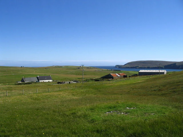
A wide view of a green, grassy landscape on Fetlar, Scotland, featuring scattered stone buildings, farm structures, rolling hills, and a glimpse of the ocean in the distance under a clear blue sky.
The settlement of Southdale on Fetlar, with the Manse and Tresta visible in the landscape.

Fetlar history and protected-area timeline

Human presence on Fetlar stretches far back into prehistory. The Funzie Girt, a monumental ancient wall that divides the island, is thought to date from the Mesolithic period, making it one of the most impressive prehistoric structures in the Shetland Islands. The wall's significance was so clear to later inhabitants that Norse settlers treated the two halves of the island as East and West Fetlar, a division that survived in language long after the wall's original purpose faded from living memory.

The island's Norse heritage is reflected in its recorded history. The earliest surviving name, Fætilar, is the Old Norse plural of fetill, meaning "shoulder-straps," which some scholars interpret as referring to the Funzie Girt visually "strapping" the island together. By 1490 the island was recorded as Fötilør, and by 1654 as Pheodor Oy. The island's place names, archaeology, and folklore all reflect a layered Norse and pre-Norse past.

In the nineteenth century Fetlar took on a more recognizable architectural history with the construction of Brough Lodge by Arthur Nicolson around 1820. This Gothic country house remains one of the island's most distinctive historical landmarks and is the focus of ongoing restoration by the Brough Lodge Trust. The Victorian and Edwardian era brought one of Fetlar's most distinguished figures: Sir William Watson Cheyne, born on the island, who went on to become a pioneer of antiseptic surgery alongside Lord Lister, president of the Royal College of Surgeons of England, and lord-lieutenant of the Shetland Islands from 1919 to 1930.

The twentieth and twenty-first centuries added new chapters. The Society of Our Lady of the Isles, an Anglican religious order for women, was based on Fetlar before relocating to Unst in 2015. In 2012, a fishing vessel skippered from the Fetlar area recovered what Guinness World Records recognized as the oldest message in a bottle ever found, originally released in 1914, which was later donated to the island's interpretive centre. In recent decades, community efforts through organizations like Fetlar Developments Ltd have focused on countering depopulation, installing community wind turbines, and preserving crofting life on the island.

Fetlar landscape and geographic character

Fetlar's landscape is shaped by an unusual combination of fertile lowland soils and rugged northern Scottish island terrain. The island rises to its highest point at Vord Hill, which reaches just over 150 metres and offers views across the surrounding North Isles seascape. Much of the interior reflects the island's nickname, "The Garden of Shetland," with richer soils than most Shetland crofting land and a habitat diversity that supports more than two hundred species of wild flower.

The most distinct physical feature is the Funzie Girt, an ancient wall running across much of Fetlar that effectively divides the island into two halves. While the wall's prehistoric origin is debated, its visual and historical impact remains, defining how both landscape and settlement patterns developed. The northern peninsula of Lamb Hoga and the surrounding smaller islets, including Haaf Gruney and Urie Lingey, contribute further to the island's varied coastline.

Small islands surround Fetlar on multiple sides. To the north lie Daaey, Haaf Gruney, Sound Gruney, Urie Lingey, and Uyea, while to the west the islands of Hascosay and Linga separate Fetlar from Yell across Colgrave Sound. Further to the south lie the Out Skerries and Whalsay. Together these landforms and waters create a complex archipelago setting where land, sea, and smaller islands form an interconnected coastal environment.

Fetlar ecosystems, habitats, and plant life

Fetlar's natural character is defined by the unusual fertility of its soil and the depth of its ecological communities. The island carries the local name "The Garden of Shetland" precisely because it supports a botanical richness rare in Shetland, with more than two hundred species of wild flower documented across its heaths, grasslands, and fertile patches.

Ecologically, the island's habitats are arranged in distinct zones. The northern part of Fetlar is dominated by dry heath and base-rich fen habitats protected through the North Fetlar Special Area of Conservation. These habitats, together with associated grasslands, also support populations of breeding seals. The freshwater and wetland habitat of the Loch of Funzie has particular ecological significance, providing the most important breeding habitat for red-necked phalaropes in the United Kingdom and once being the only known breeding site in the country during the 1990s.

The surrounding marine environment is equally important. Fetlar's waters contain breeding seabirds and feeding grounds that link the island to a broader network of marine protected areas, including the Fetlar to Haroldswick Nature Conservation Marine Protected Area. The overlap of terrestrial habitats, wetlands, and rich marine ecosystems gives Fetlar a layered ecological identity that distinguishes it from neighbouring Shetland islands.

Fetlar wildlife and species highlights

Fetlar's wildlife has made it one of the most important seabird islands in Britain. The island supports roughly 20,000 individual seabirds and holds nationally important populations of several species. Arctic skua, great skua, Arctic tern, and northern fulmar all breed here in numbers of conservation significance, while the Lamb Hoga peninsula and nearby Haaf Gruney are home to some of the largest colonies of European storm petrel in the region.

The species of greatest individual importance is the red-necked phalarope. Fetlar's Loch of Funzie is the most important breeding site for this small wader in the United Kingdom and during the 1990s was the only breeding site recorded in the country. Equally significant are Eurasian whimbrels, which breed in the northern parts of the island.

A particularly famous episode in Fetlar's wildlife history involved a pair of snowy owls that bred on the island through the 1960s and into the early 1970s, persisting into the 1980s before disappearing. In October 2018 another snowy owl was spotted on Fetlar, renewing attention on the island as occasional habitat for this charismatic Arctic species. The surrounding seas also support breeding seals, completing a wildlife profile that is unusually diverse for an island of Fetlar's size.

Fetlar conservation status and protection priorities

Fetlar's ecology has placed it at the centre of one of the densest concentrations of conservation designation in Shetland. Most of the island, along with associated islets, has been recognized as an Important Bird Area by BirdLife International, a designation that reflects the international significance of its breeding seabird populations and the presence of red-necked phalaropes, whimbrels, and several nationally rare breeding species.

Four overlapping designations cover the island and the seas around it. The North Fetlar Special Area of Conservation protects dry heaths and base-rich fens across the northern part of Fetlar. The North Fetlar Site of Special Scientific Interest extends that protection to surrounding smaller islands, with a focus on grasslands and heaths that support breeding seals and seabirds. The Fetlar Special Protection Area covers both the island itself and a substantial area of surrounding sea in recognition of the habitat value for breeding seabirds. The Fetlar to Haroldswick Nature Conservation Marine Protected Area extends marine protection across roughly 21,600 hectares of sea, completely surrounding Fetlar and stretching from Colgrave Sound to Haroldswick on Unst.

The northern part of the island is managed as an RSPB reserve, providing a focal point for ornithological research and protection. The layered nature of these designations, including both terrestrial and marine protection, makes Fetlar a model example of how a small island can carry conservation significance far beyond its geographic scale.

Fetlar cultural meaning and human context

Fetlar's cultural identity is anchored in its deep Norse and prehistoric past, its crofting traditions, and a long association with religious and scholarly life. The ancient Funzie Girt connects the island to a prehistoric cultural landscape that predates written history, while the Norse name Fætilar and continued tradition of treating East and West Fetlar as separate lands preserve a layered Scandinavian heritage.

The crofting and rural traditions of Fetlar remain a living part of the island's culture. Annual sheepdog trials, once a major fixture of island life, and the now historical Fetlar Foy, traditionally held at midsummer on the Links at Tresta, both reflect the close connection between Fetlar's community and the rhythms of its landscape. Brough Lodge, the Gothic country house built around 1820 and now under the care of the Brough Lodge Trust, brings nineteenth-century estate architecture into the island's cultural fabric.

Fetlar's most celebrated cultural son is Sir William Watson Cheyne, whose career in antiseptic surgery and his later role as lord-lieutenant of the Shetland Islands gave the island a link to the wider British medical and political history. The island was also home to the Society of Our Lady of the Isles, an Anglican women's religious order, until the community moved to neighbouring Unst in 2015. Together, these strands of prehistoric archaeology, crofting heritage, religious presence, and notable individuals give Fetlar a cultural depth that is unusual for a small island.

Top sights and standout views in Fetlar

Fetlar's defining strengths include its position as the single most important breeding site in the United Kingdom for red-necked phalaropes and its nationally significant colonies of Arctic skua, great skua, and storm petrel. The dense layering of conservation designations, including Important Bird Area, Special Area of Conservation, Site of Special Scientific Interest, Special Protection Area, and a marine protected area, underlines how this small island sits at the centre of one of the richest seabird regions in Britain. The island's nickname, "The Garden of Shetland," and its record of more than two hundred wild flower species give Fetlar an unusually rich botanical identity.

Equally distinctive is Fetlar's prehistoric and cultural heritage, anchored by the iconic Funzie Girt, an ancient wall dating potentially to the Mesolithic period, and the Gothic Brough Lodge, an early nineteenth-century landmark under restoration. The island's connection to Sir William Watson Cheyne adds a notable chapter of British medical history. Combined, these features make Fetlar a place where natural heritage and human history meet with unusual intensity.

Best time to visit Fetlar

Fetlar's character shifts with the seasons in ways typical of the northern Shetland Islands. Late spring and early summer bring the peak of breeding seabird activity, when Arctic skuas, great skuas, Arctic terns, and storm petrels are most active around the northern cliffs and smaller surrounding islets. This is also when the red-necked phalaropes are most likely to be observed around the Loch of Funzie, making it the best general period for wildlife interest.

Midsummer has historically been the cultural focus of the island, traditionally marked by the Fetlar Foy at the Links at Tresta, and today by annual sheepdog trials, normally held in July. Late summer brings long daylight hours and the warmest sea and air conditions, though weather across all seasons remains characteristically variable. Out of season, the island is quieter, its botanical fertility less obvious, and its prehistoric and architectural heritage, including the Funzie Girt and Brough Lodge, become the primary points of interest.
Monthly climate preview

Trace average temperature and monthly precipitation patterns across Fetlar.

Fetlar Climate Normals and Long-Term Weather by Month

Representative baseline coordinates trace measured annual temperature and precipitation rhythms across Fetlar from long-term observations. Opening the complete monthly record reveals detailed climate normals and broader twelve-month temperature variations.
Annual mean9 °C
6 °C13 °C
Jan
Feb
Mar
Apr
May
Jun11°
Jul13°
Aug13°
Sep12°
Oct10°
Nov
Dec
Warmest month
August

13.2 °C

Coolest month
February

5.8 °C

Wettest month
November

4.3 mm/day

Driest month
May

2 mm/day

Park location guide

Geography guide, regional context, and park location map for Fetlar

Fetlar park geography, regions, and map view in United Kingdom

Understand where Fetlar sits in United Kingdom through a broader geographic reading of the surrounding landscape, nearby location context, and its mapped position within the national park landscape.

How Fetlar fits into United Kingdom

The United Kingdom is a parliamentary constitutional monarchy located in northwestern Europe, consisting of four constituent countries: England, Scotland, Wales, and Northern Ireland. As a major global power with over 69 million residents, it maintains significant international influence in politics, economics, and culture.

Wider geography shaping Fetlar in United Kingdom

The United Kingdom is an island nation located in northwestern Europe, surrounded by the Atlantic Ocean, North Sea, English Channel, Celtic Sea, and Irish Sea. It shares a land border with the Republic of Ireland to the west. The territory includes the island of Great Britain, the northeastern portion of Ireland, and most of the smaller British Isles islands.

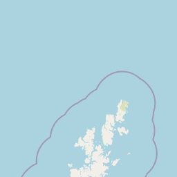
Map view of Fetlar

Use this park location map to pinpoint Fetlar in United Kingdom, understand its exact geographic position, and read its mapped placement within the surrounding landscape more clearly.

Pigeon | © OpenStreetMap contributors

Location context for Fetlar

ScotlandShetland Islands
Recorded earthquake history

Review the Historical Earthquake Catalogue for the Island of Fetlar

Access the recorded history of seismic activity near Fetlar to observe historical patterns in the Shetland Islands. This archive provides specific event data and epicentre distances to support geographic and regional study of the North Isles.

Fetlar Earthquake History Records

Catalogued events

1 event

Strongest magnitude

Magnitude 3.3

Most recent event

Jan 15, 2009

This history includes earthquakes recorded inside the park or within 50 km of its borders

Explore photographic records of terrain, seabird colonies, and coastal geography.

Fetlar Photos and Protected Landscape Scenery: Visualising Island Habitats

Visual documentation captures the rugged terrain, fertile soils, and fragile coastal habitats defining Fetlar. Photographic collections provide direct insight into the protected environment and characteristic scenery of this northern island.

A wide view of a green, grassy landscape on Fetlar, Scotland, featuring scattered stone buildings, farm structures, rolling hills, and a glimpse of the ocean in the distance under a clear blue sky.

Park atlas

Compare surrounding northern island seabird reserves and coastal protected geography

Parks Near Fetlar and Connected Protected Landscapes in the Shetland Islands

Browse other protected areas and island nature reserves located across the surrounding North Isles archipelago. Continuing the geographic comparison allows visitors to evaluate wider Scottish island ecosystems alongside Fetlar.
A soft watercolor painting of the island of Mousa in Shetland, depicting green and tan grassy hills surrounded by water, with the tall stone silhouette of the Mousa Broch visible on the island.
Wildlife reserveShetland Islands
About 62 km away#1 closest

South

Mousa, Shetland Wildlife Reserve: Mapping the Geography of a Northern Coastal Protected Area

Ancient broch ruins and critical island wildlife habitat

Mousa, Shetland provides a unique look at isolated island geography, featuring layered sedimentary geology and a high-density seabird ecosystem. Gain geographic insight into this protected site, encompassing historical Iron Age structures alongside vital nesting grounds located within the broader marine landscape of the Shetland archipelago.

Area
1.8 km²
Relief
Lowland
Climate
Temperate
Access
Moderate access
Marine protected areaShetland
About 71 km away#2 closest

South

Boddam Marine Protected Area: A Geographic Profile of Southern Shetland Coastal Waters

Coastal conservation landscapes and North Atlantic marine ecology

Located on the southern Mainland of Shetland, the Boddam Marine Protected Area stands as a vital site for marine conservation. The region is widely recognized for its consistent sandeel populations, which provide essential nourishment for seabirds and predatory marine mammals. This site combines a rich Norse crofting history with a sheltered maritime geography, offering a window into the interconnectedness of land and sea in the northern reaches of Scotland.

Relief
Lowland
Water
Major water bodies
Marine protected areaScotland
About 163 km away#3 closest

Northwest

Faroe-Shetland Sponge Belt MPA: Geographic Overview and Submarine Landscape Mapping

A deep-sea marine protected area in the Faroe-Shetland Channel

Delve into the geography of the Faroe-Shetland Sponge Belt MPA, where unique deep-sea sponge communities define the seafloor at depths between 400 and 600 meters. This site showcases the influence of hydrodynamic interactions between the North Atlantic and the Norwegian Sea on marine habitat distribution, offering a detailed look at offshore conservation within the Scottish maritime territory.

Area
5,278 km²
Established
2014
Relief
Lowland
Climate
Subpolar
Wildlife reserveOrkney
185 km away#4 closest

Southwest

Rousay Wildlife Reserve: Mapped Geography and Protected Landscapes in the Orkney Archipelago

Island moorlands, coastal cliffs, and freshwater loch ecosystems.

Rousay represents a critical protected area within the Orkney islands, characterized by its elevated moorland summits and dramatic shorelines. The mapped terrain reveals complex interactions between marine sounds and terrestrial habitats, offering a deep look into the regional geography and conservation status of this northern sanctuary.

Area
48.6 km²
Relief
Upland
Climate
Temperate
Access
Moderate access
A minimalist, stylized vector illustration of coastal cliffs meeting the sea, with a lighthouse visible in the distance on top of the headland.
Marine protected areaHighland
About 258 km away#5 closest

Southwest

Noss Head Marine Protected Area: Highland Coastal and Benthic Geography

Exploring the rocky cliffs and offshore mussel habitats of Northern Scotland.

Noss Head is a notable marine protected area located on the Caithness coast of the Scottish Highlands. The site is defined by its rugged coastal cliffs and an expansive, nationally important horse mussel bed that occupies the seabed at depths between 35 and 45 metres. This area represents a core study in North Atlantic benthic ecology and dramatic maritime landforms.

Area
8 km²
Established
2014
IUCN
IV
Relief
Lowland
Nature reserveScotland
263 km away#6 closest

Southwest

East Caithness Cliffs Nature Reserve: Regional Geography and Coastal Protected Area Atlas

Coastal sandstone cliffs and maritime heath habitats in northern Scotland.

Examine the layered conservation architecture and physical geography of East Caithness Cliffs. This site serves as a prime example of protected northern coastal terrain, where sandstone formations and maritime heath support vast seabird populations across a mosaic of land and sea boundaries.

Area
116.96 km²
Established
1996
Relief
Upland
Climate
Temperate
A watercolor painting showing a wide, sweeping landscape of green hills, a winding stream, and flat boggy terrain under a soft, light-colored sky.
Nature reserveScotland
About 284 km away#7 closest

Southwest

Flow Country: Geography and Protected Landscape Analysis of Scotland's Blanket Bog

Northern Scotland's vast, waterlogged peatland ecosystem.

The Flow Country is defined by its extensive, open peatland terrain stretching across Caithness and Sutherland. This nature reserve serves as a critical geographic study area for understanding blanket bog formation, carbon storage, and the restoration of fragile wetland habitats in northern Europe.

Area
4,000 km²
Relief
Lowland
Scope
Terrestrial
Water
Water-dominated
Marine protected areaScotland
About 307 km away#8 closest

Southeast

Norwegian Boundary Sediment Plain: A Deep Marine Protected Area in the North Sea

Submerged sand and gravel seabed habitats at the Scottish border.

Located at the outer limits of Scottish waters, the Norwegian Boundary Sediment Plain represents a specialized Marine Protected Area. It features a vast, flat sedimentary seafloor dominated by sand and gravel. This deep-water environment supports ancient benthic populations and offers a unique perspective on the stable, cold-water ecosystems found in the northern North Sea.

Area
164 km²
Established
2014
Relief
Lowland
Scope
Marine

Common questions about visiting, size, designation, and location context for Fetlar

Fetlar FAQs for park facts, access, geography, and protected area context

Find quick answers about Fetlar, including protected-area facts, park geography, trail and visitor context, and how the park fits into its surrounding country and regional landscape.
MoriAtlas Explorer

Continue Your Protected Areas Search Across the Global Atlas

Deepen your exploration by continuing the structured search for national parks and protected areas worldwide. Utilize the comprehensive filtering capabilities to compare different conservation landscapes and refine your understanding of global park geography. Discover more about the distribution and characteristics of protected natural areas.

Global natural geography