Mori Atlas logo
Protected areaFeuchtgebiet am mittleren Niger

Mapping the floodplain ecosystems and river channels of the Dosso region in southwestern Niger

Feuchtgebiet am mittleren Niger: Protected Wetland Landscapes and River Geography

(Zone humide du moyen Niger)

Feuchtgebiet am mittleren Niger serves as a critical protected wetland corridor along the Niger River. This atlas entry details the floodplain morphology, seasonal inundation patterns, and permanent aquatic zones that define this Sahelian landscape. Understand the geographic significance of these interconnected channels and marsh habitats as they traverse the Dosso region, providing essential refuge for migratory waterbirds and local freshwater species.

Ramsar sitewetlandriver floodplainNiger RiverSudano-Sahelian ecosystemswaterbirds

Feuchtgebiet am mittleren Niger

Protected area

Park overview

Structured park overview, official facts, and landscape profile for Middle Niger Wetland

Middle Niger Wetland park facts, protected area profile, and essential visitor context

Review the core facts for Middle Niger Wetland, including designation, size, terrain, visitor scale, habitats, and operating context in one park-focused overview.

About Middle Niger Wetland

The Middle Niger Wetland (Zone humide du moyen Niger) is one of a pair of Ramsar-listed wetland complexes along the Niger River in southwestern Niger. Falling within the Dosso Region, the site encompasses roughly 52,180 hectares of river channel, floodplain, and seasonally flooded terrain on the left bank of the middle Niger. It overlaps two rural municipalities: Sambéra in Dosso Department and Tanda in Gaya Department, where villages such as Bangaga Rimaibe, Koulou, Kounkouroutou Koira, Larrey, Ounna, Yoldé, Albarkaïzé, and Sia are closely linked to the wetland's landscape.

The wetland's character is defined by the seasonal rhythm of the Niger. Beyond the main river channel, the site includes temporary ponds that appear during high-water periods, as well as the zone where the Walwal dry valley meets the river. This combination of permanent flow, floodplain inundation, and ephemeral pools creates a broad gradient of aquatic and semi-aquatic habitats that stand out against the surrounding Sudano-Sahelian environment.

Ecologically, the site is recognized for its importance to migratory and resident waterbirds, while its river and flood waters host a diverse freshwater fish fauna. The vegetation mirrors the wetland's hydrology, with stands of doum palms along certain stretches, grasses adapted to seasonal flooding, mimosa thickets on wetter ground, and white water lilies in open pools. Together, these features make the Middle Niger Wetland a regionally significant refuge for biodiversity in West Africa's drylands and a key component of Niger's international wetland conservation commitments.

Quick facts and research context for Middle Niger Wetland

The Middle Niger Wetland is a Ramsar site in Niger's Dosso Region, established on 17 June 2001. It spans roughly 52,180 hectares along the left bank of the Niger River. Its territory spans the communes of Sambéra (Dosso Department) and Tanda (Gaya Department), and it adjoins the Middle Niger Wetland II Ramsar site to the south. The site includes a section of the Niger River, its floodplain, and seasonal pools including the mouth of the Walwal dry valley.

Protection and recognition

Documented terrestrial protection scope and international Ramsar site records

Feuchtgebiet am mittleren Niger Protection Status and Ramsar Recognition

Feuchtgebiet am mittleren Niger maintains a terrestrial protection scope backed by official Ramsar wetland designation records. Official recognition sources outline the documented administrative framework and international status governing the protected landscape.

International recognition

Protection details

Protection scope
Terrestrial
Transboundary protection
No
Park context

Deeper park guide and search-rich context for Middle Niger Wetland

Middle Niger Wetland history, landscape, wildlife, and travel context

Explore Middle Niger Wetland through its history, landscape character, ecosystems, wildlife, conservation priorities, cultural context, and seasonal travel timing in a structured park guide built for atlas discovery and search intent.

Why Middle Niger Wetland stands out

The site is best known for its role as a Ramsar-protected floodplain section of the Niger River in the Sahel, important for migratory waterbirds and freshwater fish. The wetland combines flowing river habitat, floodplain marshes, and seasonal ponds, creating conditions that support diverse aquatic and semi-aquatic species in an otherwise dry regional landscape.
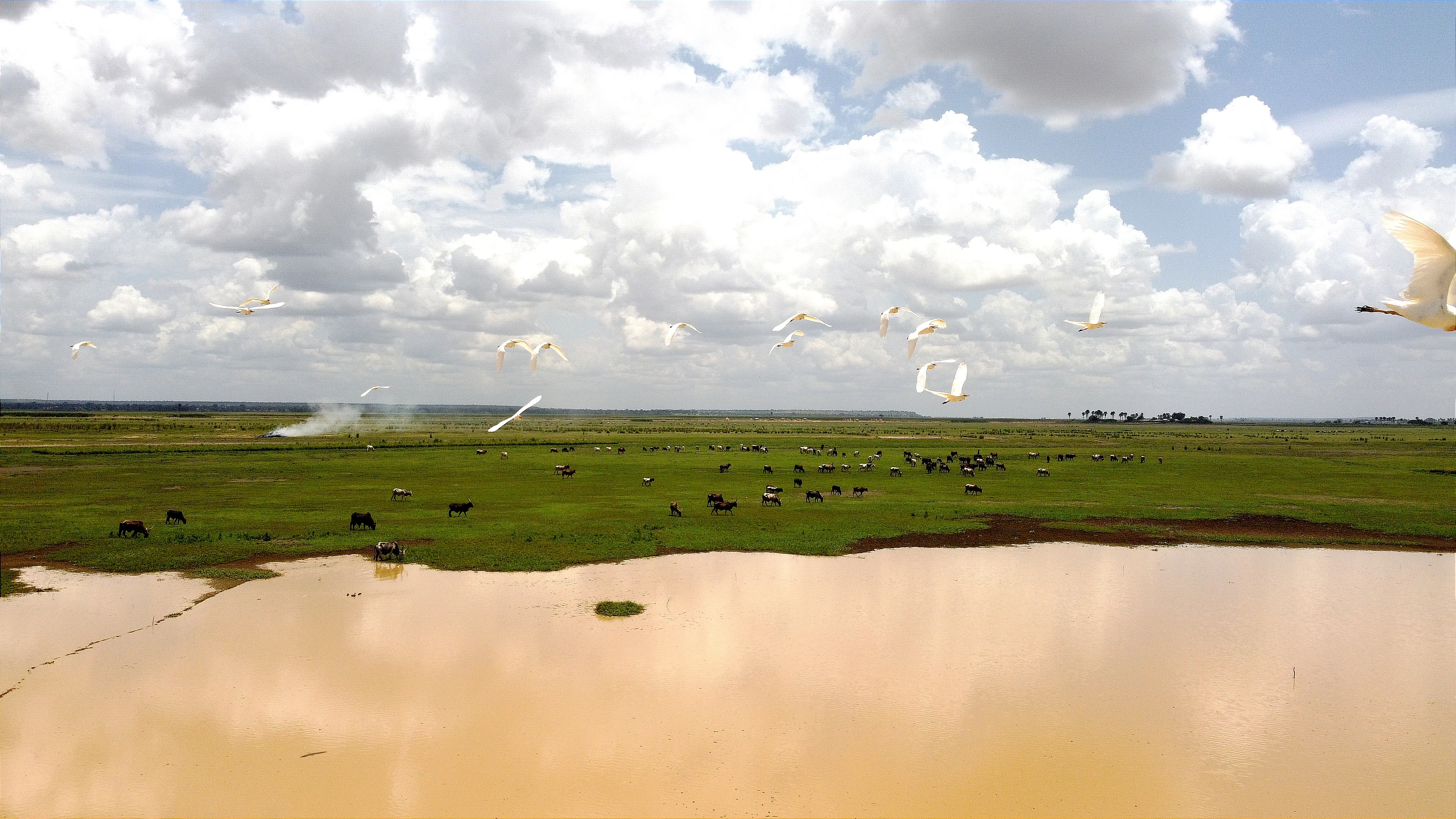
A wide view of a shallow wetland with a muddy pond in the foreground and a green grassy plain in the background, with a flock of white cattle egrets flying across the sky under a cloudy day.
A flock of cattle egrets flying over the wetland plains of the Mare de Albarkaize.

Middle Niger Wetland history and protected-area timeline

The Middle Niger Wetland achieved international recognition when it was designated as a Ramsar site on 17 June 2001, placing it under the protection framework of the Ramsar Convention. This designation followed growing awareness of the ecological value of the Middle Niger floodplain system and its importance for migratory waterbirds and freshwater biodiversity in the Sahel.

The site forms part of a broader effort to conserve representative wetland habitats along the Niger River. Located upstream of the similarly named Middle Niger Wetland II, the two Ramsar sites together cover complementary stretches of the river and its floodplain in the Dosso Region. Within the wetland, research such as the 2007 study of the Albarkaïzé pond has contributed to understanding the spatiotemporal dynamics of the ecosystem, supporting ongoing management and conservation attention for the area.

Middle Niger Wetland landscape and geographic character

The landscape of the Middle Niger Wetland is shaped by the Niger River as it meanders through the Dosso Region in southwestern Niger. On the left bank, the protected area combines sections of the main river channel with broader floodplain surfaces that are periodically inundated. Beyond the active river corridor, the wetland includes both permanent and temporary standing waters, including seasonal ponds and the area where the Walwal dry valley discharges into the Niger.

Topographically, the terrain is low-lying and defined by hydrology rather than elevation, with subtle shifts between flowing channels, flood-influenced flats, and zones that only carry water during the wet season. Clusters of doum palms and mimosa thickets punctuate the floodplain, while open water surfaces support floating aquatic plants such as the white water lily. The wider landscape beyond the wetland transitions into the typical vegetation patterns of the Sudano-Sahelian zone, making the wetland a distinctive green-blue corridor embedded in an otherwise seasonally dry environment.

Middle Niger Wetland ecosystems, habitats, and plant life

Ecologically, the Middle Niger Wetland represents a Sudano-Sahelian floodplain system, where the annual cycle of the Niger River dictates habitat structure. The transition between flowing river, seasonally flooded plains, and ephemeral pools creates a mosaic of aquatic, marshy, and seasonally wet habitats that are unusual in this largely dry region.

Vegetation reflects this hydrological gradient. The doum palm (Hyphaene thebaica) is among the most conspicuous plants, particularly along parts of the floodplain edge. Grass species adapted to wet conditions, including Anthephora nigritana and Echinochloa stagnina, dominate seasonally flooded surfaces. Shrubby mimosa (Mimosa pigra) forms thickets in wetter or recently disturbed areas, while floating plants such as the white water lily colonize open pools, completing the wetland's botanical character.

Middle Niger Wetland wildlife and species highlights

The Middle Niger Wetland supports a notable community of waterbirds, reflecting its role as a haven for both resident and migratory species along the middle Niger. Bird species recorded as important at the site include the garganey, the white-faced whistling duck, the little egret, the ruff, the spur-winged goose, and the knob-billed duck, all of which are typical of Sahelian riverine and floodplain environments.

The river and floodplain waters are also home to a diverse freshwater fish fauna, including Alestes baremoze, Citharinus citharus, Clarias anguillaris, Distichodus brevipinnis, Heterobranchus bidorsalis, Heterotis niloticus, Hyperopisus bebe, Polypterus senegalus, and Protopterus annectens. This mix of riverine and floodplain species underscores the wetland's role as a productive aquatic ecosystem within an otherwise semi-arid regional context.

Middle Niger Wetland conservation status and protection priorities

The Middle Niger Wetland is protected under the Ramsar Convention, having been designated on 17 June 2001 as one of Niger's internationally recognized wetland sites. Its conservation significance lies in safeguarding a representative section of the Niger River floodplain, including both the main channel and its associated floodplain and seasonal pond systems, in a region where such habitats are limited.

By protecting a substantial area of floodplain, marsh, and open water, the site helps maintain habitat for migratory waterbirds moving across West Africa and for native freshwater fish populations. Together with the adjoining Middle Niger Wetland II to the south, it forms a continuous Ramsar-protected corridor along the river, strengthening the broader conservation network for Sahelian wetlands and supporting ecological connectivity along the middle Niger.

Top sights and standout views in Middle Niger Wetland

Designated as a Ramsar site in 2001, the Middle Niger Wetland safeguards roughly 52,180 hectares of floodplain and river habitat along the Niger in southwestern Niger. Its mix of flowing channels, floodplain flats, and seasonal ponds supports a rich waterbird community that includes species such as the garganey, white-faced whistling duck, and knob-billed duck. Vegetation ranges from doum palms along the floodplain edge to seasonal grasses, mimosa thickets, and floating white water lilies. Adjoining the Middle Niger Wetland II Ramsar site to the south, it forms part of a key protected corridor for biodiversity in the Sahel.

Best time to visit Middle Niger Wetland

The Middle Niger Wetland is defined by the seasonal rhythm of the Niger River, with the landscape and its wildlife varying significantly through the year. During the wet season, rising river levels expand the floodplain, replenish seasonal ponds, and bring large numbers of migratory waterbirds to the area, making this the most dynamic period for birdwatching and for observing the wetland at its fullest extent. In the dry season, as floodwaters recede, water and fish become concentrated in the main river channel and permanent pools, drawing concentrations of waterbirds and supporting traditional fisheries practiced in surrounding villages. Because access, water levels, and ecological visibility all shift with the seasons, timing a visit to coincide with either the flood season or the contracting waters of the dry season can produce very different impressions of the same landscape.
Monthly climate preview

Trace long term monthly temperature averages and precipitation rhythms for this protected region

Feuchtgebiet am mittleren Niger Climate Normals and Annual Temperature Patterns

Historical data records recorded by NASA POWER reveal distinct shifts in average temperatures and monthly precipitation amounts across the representative coordinate of Feuchtgebiet am mittleren Niger. Examining the complete twelve month climate profile provides deeper context for long term environmental conditions across the terrain.
Annual mean28 °C
25 °C34 °C
Jan25°
Feb28°
Mar31°
Apr34°
May32°
Jun30°
Jul28°
Aug26°
Sep27°
Oct28°
Nov27°
Dec25°
Warmest month
April

33.6 °C

Coolest month
December

24.6 °C

Wettest month
August

6.8 mm/day

Driest month
January

0 mm/day

Park location guide

Geography guide, regional context, and park location map for Middle Niger Wetland

Middle Niger Wetland park geography, regions, and map view in Niger

Understand where Middle Niger Wetland sits in Niger through a broader geographic reading of the surrounding landscape, nearby location context, and its mapped position within the national park landscape.

How Middle Niger Wetland fits into Niger

Niger is a landlocked West African country spanning approximately 1.27 million km², making it the largest landlocked country in the region and the second-largest landlocked nation in Africa. Over 80% of its territory lies in the Sahara Desert, with the population concentrated in clusters in the southern and western regions. The country gained independence from France in 1960 and has experienced multiple coups, most recently in 2023.

Wider geography shaping Middle Niger Wetland in Niger

Niger is located in West Africa and is landlocked, bordered by Libya (northeast), Chad (east), Nigeria (south), Benin and Burkina Faso (southwest), Mali (west), and Algeria (northwest). Over 80% of the country's land area lies in the Sahara Desert. The terrain is predominantly flat desert plains and sand dunes, with the Niger River flowing through the southwest corner near the capital Niamey.

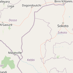
Map view of Middle Niger Wetland

Use this park location map to pinpoint Middle Niger Wetland in Niger, understand its exact geographic position, and read its mapped placement within the surrounding landscape more clearly.

Pigeon | © OpenStreetMap contributors

Location context for Middle Niger Wetland

Dosso

Visual exploration of river channels, seasonal ponds, and floodplain habitats in southwestern Niger

Feuchtgebiet am mittleren Niger Photos, Scenery, and Protected Wetland Landscapes

Visual records capture the distinctive river corridors, periodic inundation zones, and aquatic vegetation characteristic of Feuchtgebiet am mittleren Niger. Photographic documentation provides a detailed look at the wetland terrain, floodplain marshes, and protected habitats shaping the regional environment.

A wide view of a shallow wetland with a muddy pond in the foreground and a green grassy plain in the background, with a flock of white cattle egrets flying across the sky under a cloudy day.

Park atlas

Compare adjacent river floodplains, regional reserves, and wetland habitats

Explore Protected Areas and Other Parks Near Feuchtgebiet am mittleren Niger

Visitors exploring Feuchtgebiet am mittleren Niger can browse neighboring wetland reserves and protected river corridors across the surrounding region. Extending the geographic review helps map broader Sudano-Sahelian ecosystems and connected conservation landscapes.
Wildlife reserveDosso Region
Park boundaries overlap#1 closest

Southeast

Feuchtgebiet am mittleren Niger II: Wetland Geography and Wildlife Reserve Boundaries

A seasonal floodplain corridor in the Dosso Region of Niger.

Feuchtgebiet am mittleren Niger II offers a clear view into the flood-pulse ecology of the middle Niger River. The reserve comprises a complex network of channels, ponds, and riverine woodlands that shift with the annual rains. This protected site in the Dosso Region acts as a crucial transboundary conservation area, showcasing the unique interaction between riparian forests, baobab groves, and seasonal aquatic terrain.

Area
385.55 km²
Established
2004
Relief
Lowland
Scope
Terrestrial
Protected areaDosso Region
13 km away#2 closest

East

Dallol Maouri Protected Area: Geographic Overview of Niger's Fossilized Wetland Valleys

Mapping seasonal pond systems and floodplain corridors in the Dosso Region

Dallol Maouri serves as a quintessential example of the ancient drainage systems found in the Iullemmeden Basin. As a Ramsar-listed protected area, it features a unique north to south orientation that fosters a rich transition between dryland Sahel and Sudanian savanna. The valley is defined by its seasonal mares, palm groves, and intricate network of koris tributaries that shape the geography of southwestern Niger.

Area
3,175.2 km²
Established
2004
Relief
Lowland
Climate
Subtropical
A soft, light watercolor painting of a valley landscape with rolling green hills, distant purplish mountains, and patches of pink, yellow, and green vegetation.
Wildlife reserveNiger
14 km away#3 closest

Northwest

Dallol Bosso Wildlife Reserve: Geographic Atlas and Protected Landscape Context in Niger

A 350-kilometer seasonal wetland corridor and regional hydrologic system

Dallol Bosso stands as a major seasonal drainage corridor in western Niger. This wildlife reserve spans from the Malian border to the Niger River, offering a distinct study in Sahelian hydrology. Its alluvial soils and wetland characteristics support specific agricultural patterns, making it a focal point for understanding the human and natural geography of the Boboye region.

Area
8,921.22 km²
Established
2004
Relief
Lowland
Climate
Subtropical
National parkNiger
28 km away#4 closest

Northwest

W National Park: Niger National Park, UNESCO World Heritage Site & Ramsar Wetland

Transborder savanna ecosystem and dramatic Niger River landscape.

W National Park in Niger offers a unique atlas view of a vast protected landscape defined by the Niger River's iconic W-shaped bend. As a UNESCO World Heritage Site and Ramsar Wetland, it protects crucial savanna plains, extensive floodplains, and rocky outcrops. This transborder conservation area is a vital habitat for West African wildlife, providing a rich context for geographic discovery and landscape exploration.

Area
10,000 km²
Established
1954
IUCN
II
Relief
Mixed relief
National parkNiger
About 42 km away#5 closest

Northwest

W of the Niger National Park: National Park Protected Landscape and Geographic Atlas

Explore the mapped boundaries and regional geography of this protected area.

W of the Niger National Park is a designated national park offering detailed atlas-level context for its protected landscape. Users can investigate its mapped boundaries, understand its regional geographic setting, and gain insight into its unique natural terrain. This entry provides a focused view of the park's identity within the broader atlas for protected-area exploration.

Area
10,000 km²
Established
1954
Relief
Mixed relief
Climate
Tropical
A soft watercolor painting of a winding river flowing through a green woodland savanna with hills in the background.
Protected areaAlibori
About 105 km away#6 closest

South

Forêt classée de la Sota: Exploring Protected Woodlands in the Alibori Department

A historic Sudano-Sahelian savanna and riverine ecosystem

Forêt classée de la Sota stands as a critical protected woodland in northeastern Benin. This expansive 53,000 hectare reserve protects unique Sudano-Sahelian terrain defined by the Sota River basin, supporting a diverse range of savanna wildlife and complex riparian habitats across the Alibori region.

Area
530 km²
Established
1947
Relief
Lowland
Climate
Tropical
A horizontal watercolor painting showing a winding river flowing through a lush green landscape with distant rolling hills.
Protected areaBenin
About 111 km away#7 closest

Southwest

Complexe W-Arly-Pendjari: Regional Geography and Transboundary Protected Landscapes

Sudano-Sahelian savanna and riverine conservation corridors.

As a massive transboundary conservation area, the Complexe W-Arly-Pendjari protects nearly 1.5 million hectares of savanna, woodland, and rocky terrain. The complex links national parks across three countries to maintain a continuous habitat for West African megafauna. Its distinctive landscape transitions from lush gallery forests along river systems to open, dry plains, representing an essential geographic gradient for regional biodiversity.

Area
14,948.3 km²
Established
1996
Water
Major water bodies
National parkBenin
About 119 km away#8 closest

Southwest

Parc national du W du Benin: Regional Geography and Protected Savanna Landscapes

Northern Benin flagship protected area and transboundary conservation hub.

Located in northern Benin, Parc national du W du Benin provides a unique window into the Sudano-Sahelian zone. The park features a mosaic of riverine gallery forests along the Mékrou and Alibori rivers, stretching across open Sudanian savannas to meet the rugged edges of the Atacora mountains. This protected area stands as a central pillar in the WAP complex, offering a clear map of interconnected wildlife habitats and significant ecological corridors in West Africa.

Area
5,632.8 km²
Established
1950
IUCN
II
Relief
Upland

Common questions about visiting, size, designation, and location context for Middle Niger Wetland

Middle Niger Wetland FAQs for park facts, access, geography, and protected area context

Find quick answers about Middle Niger Wetland, including protected-area facts, park geography, trail and visitor context, and how the park fits into its surrounding country and regional landscape.
MoriAtlas Explorer

Continue Your Protected Areas Search Across the Global Atlas

Deepen your exploration by continuing the structured search for national parks and protected areas worldwide. Utilize the comprehensive filtering capabilities to compare different conservation landscapes and refine your understanding of global park geography. Discover more about the distribution and characteristics of protected natural areas.

Global natural geography