
Mori Atlas logo
Nature reserveFeuchtgebiete um Bad Schussenried

A complex mosaic of raised bogs, calcareous fens, and floodplain forests in Upper Swabia

Feuchtgebiete um Bad Schussenried: Mapped Wetland Landscapes and Protected Area Geography

(FFH-Gebiet Feuchtgebiete um Bad Schussenried)

Feuchtgebiete um Bad Schussenried represents a significant protected area network within the Upper Swabian hill country of Baden-Württemberg. This nature reserve encompasses seven distinct sub-areas featuring a mosaic of nutrient-rich ponds, floating bog mats, and rare calcareous spring mires. The terrain showcases glacially shaped basins and peatlands that provide vital habitats within the broader German landscape.

wetlandsFFH siteNatura 2000Upper Swabiaraised boglowland fen
A vibrant graphic illustration depicting a steep mountain canyon with a two-tiered waterfall cascading into a calm lake where a small rowboat floats among lily pads, framed by foreground coniferous trees.

Feuchtgebiete um Bad Schussenried

Nature reserve

Park overview

Structured park overview, official facts, and landscape profile for Feuchtgebiete um Bad Schussenried

Feuchtgebiete um Bad Schussenried park facts, protected area profile, and essential visitor context

Review the core facts for Feuchtgebiete um Bad Schussenried, including designation, size, terrain, visitor scale, habitats, and operating context in one park-focused overview.

About Feuchtgebiete um Bad Schussenried

Feuchtgebiete um Bad Schussenried is a European-protected wetland complex in southeastern Baden-Württemberg, southwestern Germany. Although it does not carry the title of a national park, it functions as a major component of the European Natura 2000 ecological network, protecting habitat types and species listed under the EU Habitats Directive (Richtlinie 92/43/EWG). With around 610 hectares distributed across seven discrete sub-areas, the site is structured as a mosaic reserve rather than a single contiguous block.

Geographically, the area sits in the Oberschwäbisches Hügelland, the gently rolling hill country of Upper Swabia. This region was shaped by Pleistocene glaciation, leaving behind a distinctive pattern of kettle holes, peat-filled depressions, and shallow lakes. The result is a landscape where open water, wetland margin habitats, and varied forest types interlock over short distances, supporting a disproportionately rich biodiversity.

The reserve's component areas centre on the historic spa town of Bad Schussenried in the Landkreis Biberach, and extend into neighbouring parts of the Landkreis Ravensburg around Aulendorf and Bad Waldsee. The Schwaigfurter Weiher, one of the well-known waterbodies, exemplifies the kind of small, nutrient-rich lake with rich marginal vegetation that defines the site.

Beyond its ecological value, Feuchtgebiete um Bad Schussenried is part of a broader conservation narrative for Upper Swabia, a region historically shaped by peat cutting, traditional meadow use, and small-scale farming. Modern protection recognises that these long-used landscapes still harbour rare habitat types such as species-rich hay meadows and calcareous fens, provided their traditional management continues. The site therefore stands at the intersection of cultural landscape and modern habitat conservation.

Quick facts and research context for Feuchtgebiete um Bad Schussenried

Feuchtgebiete um Bad Schussenried is a Natura 2000 / FFH protected area in the southeast of Baden-Württemberg, Germany, with the EU site code DE-8024-341. The site covers approximately 610 hectares and is divided into seven separate sub-areas (Teilgebiete) spread around the towns of Bad Schussenried, Aulendorf, and Bad Waldsee.

Administratively it falls within the Regierungsbezirk Tübingen and is overseen by the Regierungspräsidium Tübingen, with a formal protection ordinance that came into force on 11 January 2019. The protected-area mosaic includes lakes, fens, bogs, reedbeds, wet meadows, moor forests, alder floodplain forests, and beech woodlands. It hosts several Annex II species of the Habitats Directive, including the European beaver, greater mouse-eared bat, northern crested newt, the lady's slipper orchid, and several rare Vertigo snails.

Protection and recognition

Review documented international recognition and designated boundary sources.

Feuchtgebiete um Bad Schussenried Protection Status and Natura 2000 Records

Feuchtgebiete um Bad Schussenried maintains documented protection status through verified Natura 2000 recognition sources and administrative boundaries. Structured records outline official designation frameworks and international conservation entries associated with the protected landscape.
Park context

Deeper park guide and search-rich context for Feuchtgebiete um Bad Schussenried

Feuchtgebiete um Bad Schussenried history, landscape, wildlife, and travel context

Explore Feuchtgebiete um Bad Schussenried through its history, landscape character, ecosystems, wildlife, conservation priorities, cultural context, and seasonal travel timing in a structured park guide built for atlas discovery and search intent.

Why Feuchtgebiete um Bad Schussenried stands out

Feuchtgebiete um Bad Schussenried is best known for its dense patchwork of small wetland habitats, including nutrient-rich lakes, lowland and raised mires, calcareous fens, and floating bog mats typical of the Upper Swabian landscape. The site's combination of open water, transitional mires, and surrounding wet forests creates a particularly rich habitat mosaic in a relatively compact area. The reserve is also notable among European conservation sites for the concentration of rare micro-molluscs such as Vertigo geyeri, Vertigo angustior, and Vertigo moulinsiana, which rely on intact calcareous and transitional mire conditions. It is one of a chain of large FFH wetland sites that define the wet character of Upper Swabia between Bad Schussenried, Aulendorf, and Bad Waldsee.
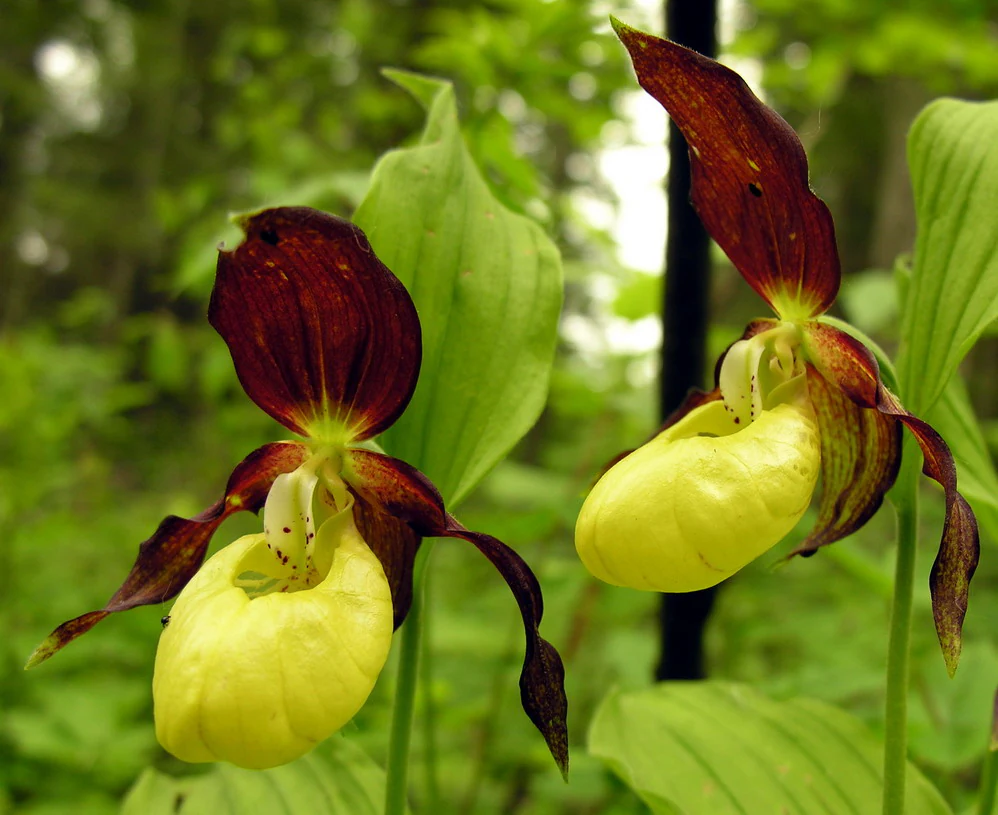
Two yellow and dark red lady's slipper orchids in bloom, with green foliage in the background.
The lady's slipper orchid, a rare protected species found within the wetland habitats.

Feuchtgebiete um Bad Schussenried history and protected-area timeline

The conservation history of Feuchtgebiete um Bad Schussenried begins in 2005, when the Regierungspräsidium Tübingen proposed the area as a candidate Fauna-Flora-Habitat (FFH) site to the European Commission under the EU Habitats Directive. The proposal recognised the exceptional concentration of wetland habitats and protected species in the area around Bad Schussenried, Aulendorf, and Bad Waldsee, and was later reflected in the official European site code DE-8024-341.

A formal protection ordinance was prepared through a management planning process that culminated in late 2016, when a detailed Managementplan for the FFH-Gebiet 8024-341 was drafted. The site was then formally designated by ordinance of the Regierungspräsidium Tübingen on 5 November 2018, with the regulation entering into force on 11 January 2019. Since that date, the seven sub-areas of the reserve have been protected under Baden-Württemberg's Natura 2000 framework, administered from Tübingen.

Feuchtgebiete um Bad Schussenried landscape and geographic character

The landscape of Feuchtgebiete um Bad Schussenried is shaped by the gentle topography of the Upper Swabian hill country, a glacially formed region between the Alps and the Danube that contains numerous lakes, ponds, and peatlands. Within the protected area, this broader setting is expressed in a series of small-scale landforms: kettle-hole lakes, shallow mire basins, slowly flowing brooks, and the transition zones where fenland meets woodland.

The seven sub-areas together describe a landscape mosaic rather than a single uniform terrain. Around Bad Schussenried, open water and mires dominate, with Weiher (ponds) such as the Schwaigfurter Weiher set among reedbelts, sedge stands, and floating bog mats. Towards Aulendorf and Bad Waldsee, bog woodland (Moorwälder), alder floodplain forests, and beechwoods become more prominent, softening the agricultural matrix in which the wetlands sit.

Calcareous seepage springs, locally known as Kalktuffquellen, add a further distinctive feature. Where calcium-rich groundwater emerges, it deposits tufa and creates specialised mire habitats that are unusual outside a few regions of southern Germany. This combination of lakes, springs, peatlands, and forests in close proximity is what gives the site its geographic coherence.

Feuchtgebiete um Bad Schussenried ecosystems, habitats, and plant life

The ecological identity of Feuchtgebiete um Bad Schussenried is built around its rich variety of wetland habitat types. Several habitat types listed under Annex I of the EU Habitats Directive are present, including natural eutrophic lakes with pondweed or frogbit vegetation, species-rich hay meadows, calcareous fens with Cladium mariscus and Caricion davallianae species, calcareous spring mires (Kalktuffquellen), bog woodland (Moorwälder), alder and ash floodplain forests, and acidophilous spruce forests of the montane to alpine Vaccinio-Piceetea class.

The site's habitat class breakdown shows a landscape in which forest and wetland habitats are tightly interwoven. Broadleaf woodland makes up roughly 21 percent of the area, mixed woodland 19 percent, and coniferous woodland 25 percent. Wet and mesophilous grassland accounts for approximately 18 percent, while inland standing and running waters cover 4 percent. Mires, swamps, and shore vegetation contribute around 7 percent, with drained grassland and other arable land each occupying about 3 percent of the total area.

Transitional stages of open water, from open lake surfaces through reed margins and sedge beds to wet woodland, are especially well represented. Schwingrasen (floating bog mats), reedbeds, sedge fens, and alder carrs mark successive stages of terrestrialisation, illustrating the dynamic processes by which lakes in Upper Swabia gradually transform into peatland. This sequence of successional stages gives the site both its visual character and much of its ecological importance.

Feuchtgebiete um Bad Schussenried wildlife and species highlights

Because of the diversity of habitats, Feuchtgebiete um Bad Schussenried supports a wide range of uncommon and protected species. European beaver (Castor fiber) is present in the wetter zones around the lakes and slow streams, and the site also hosts populations of the greater mouse-eared bat (Myotis myotis), which forages over the forest edges and open water.

Amphibians are well represented by the northern crested newt (Triturus cristatus), which depends on the small, fish-free ponds scattered through the reserve. The aquatic invertebrate fauna is particularly notable, including the rare micro-snails Vertigo geyeri, Vertigo angustior, and Vertigo moulinsiana, as well as Anisus vorticulus, all of which are associated with calcareous fens and transitional mires that have remained undisturbed.

In the wet meadows and spring mires, the lady's slipper orchid (Cypripedium calceolus) finds a foothold, while the varied forest structure of bog woodlands and floodplain forests supports a diverse community of woodland birds, bats, and insects. The combination of aquatic, mire, and forest habitats gives the reserve a layered wildlife profile, with each habitat type contributing its own characteristic species assemblages.

Feuchtgebiete um Bad Schussenried conservation status and protection priorities

Feuchtgebiete um Bad Schussenried is protected primarily because it preserves a rare concentration of wetland habitats and species that are priorities of the European Union's Habitats Directive. Its seven sub-areas safeguard a sequence of lakes, fens, and bogs that would otherwise be vulnerable to drainage, intensification of agriculture, peat extraction, or forestry conversion. The site's designation under EU law obliges Germany to maintain or restore the habitats and species for which it was proposed.

The reserve's conservation value lies in its unusually intact combination of open water, transitional mires, and floodplain woodland in a single landscape. The presence of habitat types such as calcareous fens, bog woodland, and alder floodplain forest, together with strictly protected Annex II species such as the European beaver, the lady's slipper orchid, and several rare Vertigo snails, places it among the more significant wetland sites in Baden-Württemberg.

Management of the site, set out in the 2016 Managementplan, focuses on preserving hydrological conditions, maintaining traditional low-intensity grassland use on hay meadows, and protecting the marginal and mire habitats around the lakes. The site is also part of the wider Natura 2000 network in Upper Swabia, complementing neighbouring reserves such as the Wurzacher Ried, Federsee, Pfrunger Ried, and other FFH wetland complexes across Biberach and Ravensburg districts.

Feuchtgebiete um Bad Schussenried cultural meaning and human context

The wetland landscape around Bad Schussenried is closely linked to the cultural identity of Upper Swabia, a region long defined by small-scale farming, hay meadow management, peatland use, and pilgrimage routs connecting monastery towns. Bad Schussenried itself developed around a former monastery and is known historically as a destination for religious visitation, while also gaining a modern profile as a climatic health resort.

Traditional land use has shaped the conservation value of the present-day reserve. Many of the species-rich meadows and structurally diverse mire margins owe their character to long-standing mowing practices and gentle grazing, rather than to deliberate rewilding. The interplay between centuries of human activity and natural hydrology is part of why these particular wetland complexes survived in such a rich form.

Top sights and standout views in Feuchtgebiete um Bad Schussenried

Feuchtgebiete um Bad Schussenried stands out for its tightly packed mosaic of seven protected wetland sub-areas within a small region of Upper Swabia, combining lakes, raised and lowland mires, calcareous fens, and floodplain forests. Notable highlights include the Schwaigfurter Weiher and similar small waterbodies with intact marginal vegetation, the well-preserved floating bog mats and reedbeds, and the presence of calcareous spring mires formed by tufa-depositing groundwater.

The site also gains prominence from its rare fauna: a strong population of European beaver, breeding northern crested newts, several Vertigo snail species of pan-European conservation importance, and isolated occurrences of the lady's slipper orchid in the wet woodlands and meadows. Together these features make the reserve a key building block of the Natura 2000 network in southeastern Baden-Württemberg.

Best time to visit Feuchtgebiete um Bad Schussenried

The reserve can be appreciated at any time of year, but spring and early summer are particularly rewarding, when water levels in the ponds and fens are typically high, reedbeds and sedges are at their most vigorous, and breeding amphibians such as the northern crested newt are active in the small pools. Late spring and early summer also bring the flowering of meadows and orchids, including the lady's slipper.

Autumn offers a very different atmosphere: bog woodland colours turn, low mist often gathers over the still water surfaces, and beaver activity becomes easier to detect near dawn and dusk. Winter visits can be productive for observing the open structure of the wetlands and identifying the transition zones between open water, mire, and forest, though frost and damp ground can make paths around the mires unpleasant for walking.


Monthly climate preview

Long term temperature ranges and monthly precipitation records from representative coordinates

Climate Normals and Annual Weather Patterns for Feuchtgebiete um Bad Schussenried

Representative coordinates record measured monthly averages spanning sub zero winter minimums up to warm summer maximums alongside consistent daily precipitation rates. Analyzing complete twelve month temperature and rainfall datasets reveals detailed long term meteorological rhythms across the protected terrain.
Annual mean8 °C
-2 °C18 °C
Jan-2°
Feb
Mar
Apr
May13°
Jun16°
Jul18°
Aug18°
Sep13°
Oct
Nov
Dec-1°
Warmest month
July

18 °C

Coolest month
January

-1.5 °C

Wettest month
July

3.9 mm/day

Driest month
February

1.9 mm/day

Park location guide

Geography guide, regional context, and park location map for Feuchtgebiete um Bad Schussenried

Feuchtgebiete um Bad Schussenried park geography, regions, and map view in Germany

Understand where Feuchtgebiete um Bad Schussenried sits in Germany through a broader geographic reading of the surrounding landscape, nearby location context, and its mapped position within the national park landscape.

How Feuchtgebiete um Bad Schussenried fits into Germany

Germany is a federal republic in Western and Central Europe with a population of over 83 million across sixteen constituent states. It is Europe's largest economy by nominal GDP and a major global exporter and importer. The capital is Berlin, and the country borders Denmark, Poland, Czech Republic, Austria, Switzerland, France, Luxembourg, Belgium, and the Netherlands.

Wider geography shaping Feuchtgebiete um Bad Schussenried in Germany

Germany is located in Western and Central Europe, spanning 357,022 km². It borders Denmark to the north, Poland and the Czech Republic to the east, Austria and Switzerland to the south, and France, Luxembourg, Belgium, and the Netherlands to the west. The country has coastlines on the Baltic Sea and North Sea to the north, with the Alps located in the southern region.

Map view of Feuchtgebiete um Bad Schussenried

Use this park location map to pinpoint Feuchtgebiete um Bad Schussenried in Germany, understand its exact geographic position, and read its mapped placement within the surrounding landscape more clearly.

Pigeon | © OpenStreetMap contributors

Location context for Feuchtgebiete um Bad Schussenried

Baden-Württemberg
Recorded earthquake history

Explore the Historical Earthquake Records for Feuchtgebiete um Bad Schussenried

Browse the documented history of seismic events occurring near Feuchtgebiete um Bad Schussenried. MoriAtlas provides a clear catalogue of recorded epicentres and event details for those investigating the historical seismic context of this protected wetland area.

Feuchtgebiete um Bad Schussenried Earthquakes

Catalogued events

20 events

Strongest magnitude

Magnitude 5.2

Most recent event

Dec 25, 2008

This history includes earthquakes recorded inside the park or within 50 km of its borders

Visualizing the habitats, glacial mires, and protected terrain of Upper Swabia

Feuchtgebiete um Bad Schussenried Photos: Exploring Wetland Landscapes and Scenery

Visual documentation reveals the intricate mosaic of glacial lakes, floating bog mats, and wet woodlands spanning the protected sub-areas. Examining these environmental details provides a clear understanding of the rare mire topography and conservation character.

Two yellow and dark red lady's slipper orchids in bloom, with green foliage in the background.

Metal rowboats moored at the edge of a calm lake surrounded by trees and vegetation.

Park atlas

Compare adjacent wetland reserves and regional conservation areas in Upper Swabia

Parks near Feuchtgebiete um Bad Schussenried and Surrounding Protected Landscapes

Browsing other parks near Feuchtgebiete um Bad Schussenried reveals a wider network of glacial lake basins and wetland reserves across the Upper Swabian hill country. Continuing through connected protected landscapes helps place local fen habitats and regional geography into a broader conservation context.
Protected landscapeBaden-Württemberg
About 0.9 km away#1 closest

Northeast

Oberes Rißtal Protected Landscape: Glacial Geography and Wetland Corridors in Baden-Württemberg

Mapping the upper Riß river valley and its complex fen ecosystems

Oberes Rißtal stands as a crucial protected landscape in Baden-Württemberg, distinguished by its winding river meanders and multi-layered glacial terrain. This area merges the Riß and Würm ice-age legacy with active riparian habitats, including extensive lowland fens, kettle depressions, and traditional meadows. Explore the mapped boundaries and geographic features that define this essential Upper Swabian corridor.

Area
41.638 km²
Established
1975
IUCN
V
A soft, panoramic watercolor painting featuring green, rolling hills and a winding river or stream through a forested landscape against a bright, hazy sky.
Nature reserveBaden-Württemberg
4.8 km away#2 closest

South

Altdorfer Wald Nature Reserve: Geographic Atlas and Protected Landscape Overview

Mire, spring, and forest ecosystems in Baden-Württemberg

The Altdorfer Wald nature reserve consolidates a significant network of watercourses, peatlands, and old-growth forest stands across the Upper Swabian Pre-Alpine hills. This protected area stands as a primary focal point for understanding the interplay between hydrological richness, calcareous deposits, and diverse temperate forest habitats within the regional geography of Baden-Württemberg.

Area
13.71 km²
Established
2019
Relief
Upland
Climate
Temperate
A soft watercolor painting of a calm river winding through rolling green hills under a hazy sky.
Protected areaGermany
17 km away#3 closest

North

Donau zwischen Munderkingen und Riedlingen: Geography of a Danube Protected Landscape

Exploring floodplain habitats and Swabian Alb limestone terrain.

Spanning over 1,400 hectares, Donau zwischen Munderkingen und Riedlingen represents a vital protected network along the upper Danube. This area is defined by the sharp transition between dynamic wetland floodplains and the dry, calcareous grasslands of the surrounding plateau, offering a comprehensive look at the riparian and geological character of this historic German river corridor.

Area
14.33 km²
Established
2019
Relief
Lowland
Climate
Temperate
Protected landscapeBaden-Württemberg
About 18 km away#4 closest

Southwest

Pfrunger Ried, Rinkenburg Protected Landscape: Geographic and Terrain Analysis

Moorland and molasse hill system in Baden-Württemberg

Covering roughly 762 hectares in the Ravensburg district, Pfrunger Ried, Rinkenburg is a significant protected landscape known for its glacial tongue basin and peat-forming wetlands. This entry explores the interplay between the wetland systems and the prominent Tertiary molasse hill that define this distinct upper Swabian natural area.

Area
7.62 km²
Established
1967
Relief
Upland
Scope
Terrestrial
Protected landscapeBaden-Württemberg
About 23 km away#5 closest

Southeast

Uferbewuchs der Eschach Protected Landscape and Riparian Corridor Map

Riparian conservation within the Riß-Aitrach-Platten of Baden-Württemberg

Tracing the protected linear riparian corridors of the Eschach stream, this area is a significant example of urban-edge conservation in Germany. It maintains continuous stream-bank vegetation through the Leutkirch municipal landscape, linking directly to broader floodplain habitats of the Aitrach river system through its glacial-plateau geographic setting.

Established
1953
IUCN
V
A horizontal watercolor painting depicting a soft-focus valley scene with rolling hills, scattered green trees, and a light sky.
Nature reserveBaden-Württemberg
25 km away#6 closest

Southwest

Deggenhauser Tal Nature Reserve: Mapped Geography and Protected Valley Landscapes

Glacial terrain and watershed ridges in Baden-Württemberg

Investigate the protected geography of Deggenhauser Tal, an expansive nature reserve in the Oberschwäbisches Hügelland. This record maps the complex network of stream corridors, steep valley slopes, and ridge heights that define this Natura 2000 protected area. Gain insights into the glacial relief and varied land use patterns that characterize this essential southwestern German valley ecosystem.

Area
8.492 km²
Established
2019
Protected landscapeBaden-Württemberg
About 25 km away#7 closest

North

Untermarchtal Protected Landscape: Mapped Geography of the Upper Danube Valley

A regional conservation corridor within Baden-Württemberg

The Untermarchtal protected landscape features a striking transition between the broad Danube valley and the steep slopes of the Swabian Alb. This area protects diverse landforms including limestone hillsides and alluvial terrain, serving as an essential connective element in a broader network of protected lands along the upper Danube river.

Area
0.231 km²
Established
2005
IUCN
V
Protected landscapeBaden-Württemberg
About 27 km away#8 closest

Northwest

Tobeltal Protected Landscape: Geological and Geographic Profile in Baden-Wurttemberg

Mapped gorge terrain and regional conservation geography

The Tobeltal protected area features a distinctive 2.2 kilometer valley profile carved into Jurassic limestone. Its narrow gorge, wooded slopes, and Kesselbach spring wetland provide a representative example of the varied terrain found within the Mittlere Flächenalb region of Germany.

Area
0.31 km²
Established
1958
IUCN
V

Common questions about visiting, size, designation, and location context for Feuchtgebiete um Bad Schussenried

Feuchtgebiete um Bad Schussenried FAQs for park facts, access, geography, and protected area context

Find quick answers about Feuchtgebiete um Bad Schussenried, including protected-area facts, park geography, trail and visitor context, and how the park fits into its surrounding country and regional landscape.
MoriAtlas Explorer

Continue Your Protected Areas Search Across the Global Atlas

Deepen your exploration by continuing the structured search for national parks and protected areas worldwide. Utilize the comprehensive filtering capabilities to compare different conservation landscapes and refine your understanding of global park geography. Discover more about the distribution and characteristics of protected natural areas.

Global natural geography