
Mori Atlas logo
Nature reserveFeuerheck bei Waldaubach

A detailed geographic study of high elevation deciduous forests and moisture-driven woodland mosaics.

Feuerheck bei Waldaubach Nature Reserve: Mapping the Protected Upland Landscapes of Hessen

(Naturschutzgebiet Feuerheck bei Waldaubach)

Feuerheck bei Waldaubach represents a significant protected upland site within the Hoher Westerwald plateau of Hessen. Covering 24 hectares at elevations between 560 and 600 meters, this nature reserve sustains a complex mosaic of deciduous forest and meadow patches. The high-precipitation, cool climate fosters distinctive waterlogged and dry habitats that support rare orchid species, diverse butterfly populations, and breeding woodcock, functioning as a vital segment of the broader European conservation network.

nature reserveHesseLahn-Dill-KreisHoher Westerwaldupland forestdeciduous woodland
A minimalist flat illustration of a valley with green fields in the foreground, trees on the sides, and rocky cliffs in the background under a soft-colored sky.

Feuerheck bei Waldaubach

Nature reserve

Park overview

Structured park overview, official facts, and landscape profile for Feuerheck bei Waldaubach

Feuerheck bei Waldaubach park facts, protected area profile, and essential visitor context

Review the core facts for Feuerheck bei Waldaubach, including designation, size, terrain, visitor scale, habitats, and operating context in one park-focused overview.

About Feuerheck bei Waldaubach

Feuerheck bei Waldaubach is a compact nature reserve in the Hoher Westerwald, the higher northern part of the Westerwald upland range in central Hesse. Although it covers only around 24 hectares, the reserve concentrates a remarkable diversity of forest and meadow habitats into a small footprint. The site sits northeast of the village of Waldaubach in the municipality of Driedorf and lies east of the regional road that connects Waldaubach northward to Rabenscheid, placing it in a relatively quiet rural setting well away from major urban centers.

The reserve's elevation, averaging around 580 meters above sea level, gives it a noticeably cooler and wetter climate than surrounding lowlands. Annual precipitation here exceeds 1000 millimeters, feeding the varied soil profiles that shape its ecological mosaic. On drier sites, classic upland broadleaf communities thrive, while sections with impeded drainage accumulate enough moisture to support wet-loving plant communities alongside drier pockets. This combination of micro-habitats within a small reserve is the defining characteristic of Feuerheck and the reason it has attracted botanical and zoological interest.

The woodland itself is dominated by mature broadleaf species, including large old-growth maples along pathways. Scattered mosaic-like clearings and meadow fragments, along with forest edge zones, provide additional structural diversity. These transitions between closed forest, open meadow, and edge habitat are important for many invertebrates, and the reserve is especially notable for its butterfly fauna. More than 115 butterfly species have been recorded in the small area, including several rare or ecologically specialized moths such as the scarce maple carpet.

Feuerheck bei Waldaubach does not stand alone. It is part of the FFH site "Hoher Westerwald" (5314-301) under the European Habitats Directive and also sits within the European bird protection area of the same name (5314-450). Adjacent protected areas include Waldaubacher Hecke bei Rabenscheid, Rabenscheider Holz, Rückerscheid mit Aubachtal, and Bermershube bei Heisterberg, with the Fuchskaute reserve located to the southwest across the state border in Rhineland-Palatinate. Together these sites form an interconnected network of highland forest and meadow reserves in one of Hesse's most ecologically distinctive upland regions.

Quick facts and research context for Feuerheck bei Waldaubach

Feuerheck bei Waldaubach is a 24.35-hectare nature reserve (Naturschutzgebiet) in the Lahn-Dill-Kreis district of Hesse, Germany. It lies within the Hoher Westerwald at elevations of about 560 to 600 meters above sea level and receives annual precipitation exceeding 1000 mm. The reserve is managed under the Regierungspräsidium Gießen and is classified as an IUCN Category IV Habitat/Species Management Area. It forms part of the larger Hoher Westerwald FFH site and the associated European bird protection area.

Protection and recognition

Examine documented protection records and official designation details for Feuerheck bei Waldaubach.

Feuerheck bei Waldaubach Protection Status and Regional Conservation Data

Examine documented protection status records and administrative designations associated with Feuerheck bei Waldaubach. Professional atlas entries compile verified baseline data to support research into global protected areas.

Protection details

WDPA ID
163090
Park context

Deeper park guide and search-rich context for Feuerheck bei Waldaubach

Feuerheck bei Waldaubach history, landscape, wildlife, and travel context

Explore Feuerheck bei Waldaubach through its history, landscape character, ecosystems, wildlife, conservation priorities, cultural context, and seasonal travel timing in a structured park guide built for atlas discovery and search intent.

Why Feuerheck bei Waldaubach stands out

Feuerheck bei Waldaubach is best known for its high-elevation deciduous forest with a distinctly humid, cool microclimate that produces a mosaic of dry, intermediately wet, and waterlogged habitats on varied soils. It is notable for rare woodland plants such as Aconitum napellus, Aconitum lycoctonum, Platanthera chlorantha, and Campanula latifolia, and for holding more than 115 recorded butterfly species. The presence of woodcock as a breeding bird adds further ecological interest to this small but well-documented upland forest reserve.
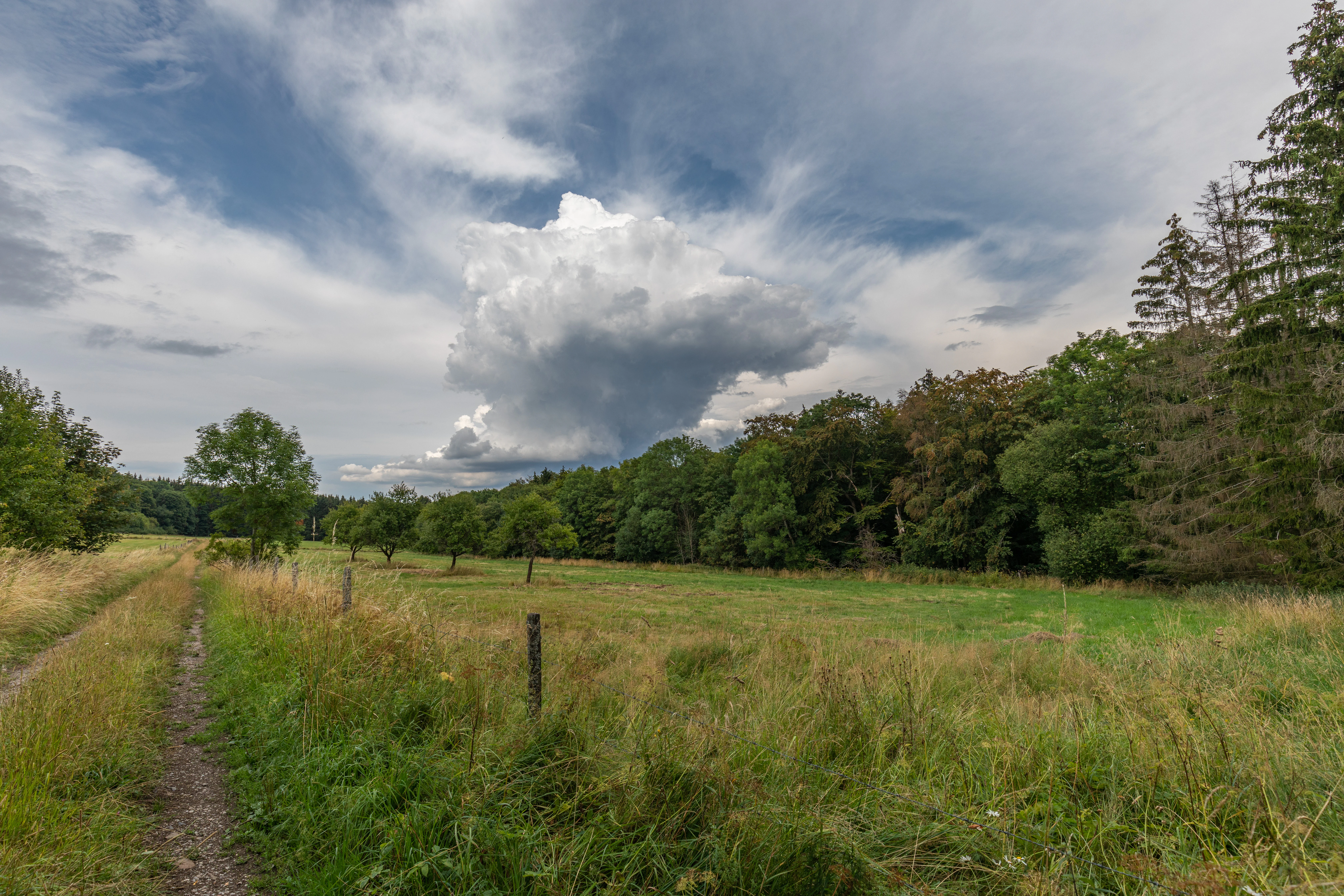
A wide view of a grassy meadow with a dirt path running along the left side, bordered by a dense line of trees under a cloudy sky.
A scenic view of the meadow and forest landscape within the Feuerheck bei Waldaubach nature reserve.

Feuerheck bei Waldaubach history and protected-area timeline

Feuerheck bei Waldaubach was formally designated as a Naturschutzgebiet, a nature protection area under Hessian nature conservation law, on 19 December 1984 and bears the official identification number 1532018. Its protection was intended to safeguard a representative section of upland deciduous forest and its associated flora, fauna, and ecological processes on the Hoher Westerwald plateau. From its establishment onward, the site has been administered by the Regierungspräsidium Gießen through its upper nature conservation authority.

In 2013, a management plan was produced for the larger FFH area "Hoher Westerwald" that includes Feuerheck. This plan formalized a long-term approach that prioritizes natural forest development, explicitly setting aside active forestry management measures within the reserve. The 2013 framework reflects a broader shift in conservation policy toward allowing undisturbed ecological succession in protected upland forest reserves, reinforcing the site's role as a reference area for natural woodland processes in the region.

Feuerheck bei Waldaubach landscape and geographic character

The landscape of Feuerheck bei Waldaubach is shaped by its position within the Hoher Westerwald, a high plateau in the Westerwald range. Elevations in the reserve range from about 560 to 600 meters above sea level, placing it firmly within the upland character of the German central highlands. The terrain is gently rolling rather than dramatic, with broad forested slopes and small valleys where drainage collects.

Despite the modest topography, the setting is visually distinctive. Dense stands of mature deciduous trees close over the paths that wind through the reserve, while occasional open meadow fragments, called mosaic meadows in local descriptions, break the canopy. These small clearings, together with the forest margin zones, create a layered landscape of closed woodland, scattered glades, and transitional edges. Where paths cross, old-growth trees including maples mark the way, lending the forest a characterful, well-developed appearance.

The high elevation also drives the climate, with annual precipitation exceeding 1000 millimeters and consistently cool, humid conditions. Because the soils vary across the site, not all of this moisture drains evenly. The result is a patchwork of dry, intermediately wet, and persistently waterlogged patches, each supporting a different plant community. This fine-scale variation in moisture and substrate is one of the defining physical features of Feuerheck and a defining element of its landscape identity.
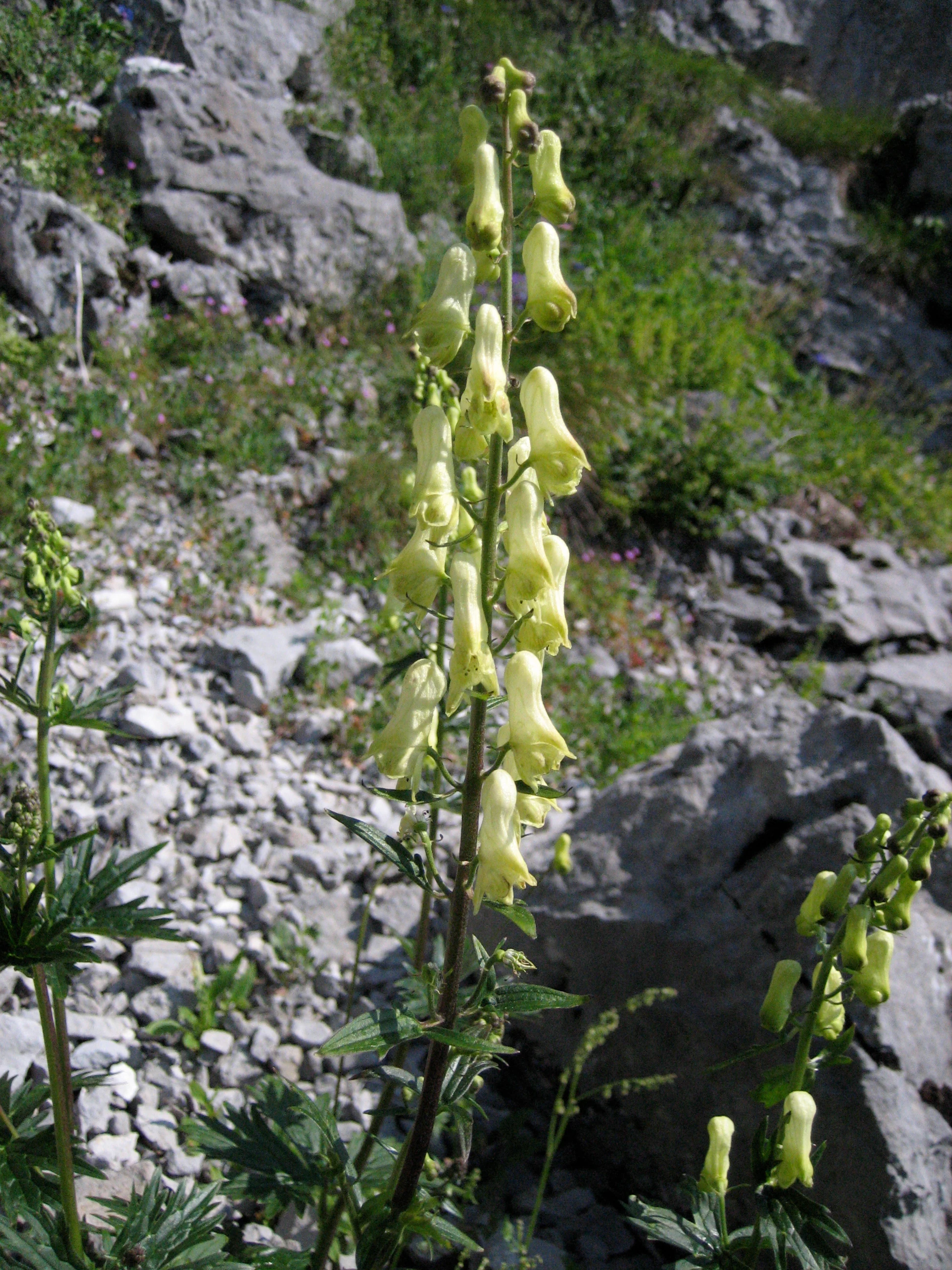
A close-up view of a tall, yellow monkshood plant with pale yellow flowers blooming on a central stalk, set against a background of grey rocks and sparse green vegetation.
Yellow monkshood (Aconitum lycoctonum) growing in a rocky area within the reserve.

Feuerheck bei Waldaubach ecosystems, habitats, and plant life

Feuerheck bei Waldaubach is ecologically defined by its high-elevation broadleaf forest system and the unusually rich moisture gradient that runs through it. Annual rainfall above 1000 mm and an average elevation near 580 meters combine to produce a distinctly cool, humid microclimate for central Germany. Because different soil types inside the reserve drain at very different rates, the woodland supports a juxtaposition of dry, intermittently moist, and permanently waterlogged zones in close proximity.

This micro-mosaic creates the conditions for a wide range of forest plant communities. Open meadow fragments add further botanical variety, and the closed-canopy forest together with the forest-edge transitions provide structural diversity on a small scale. Many of the rare species supported here are tightly linked to these old-growth broadleaf stands, particularly to mature maple, whose old trees along the paths are notable features of the reserve. The combination of long-established native deciduous trees, undisturbed soil conditions, and the absence of recent forestry intervention makes the site ecologically coherent and unusually undisturbed for a small Hessian nature reserve.
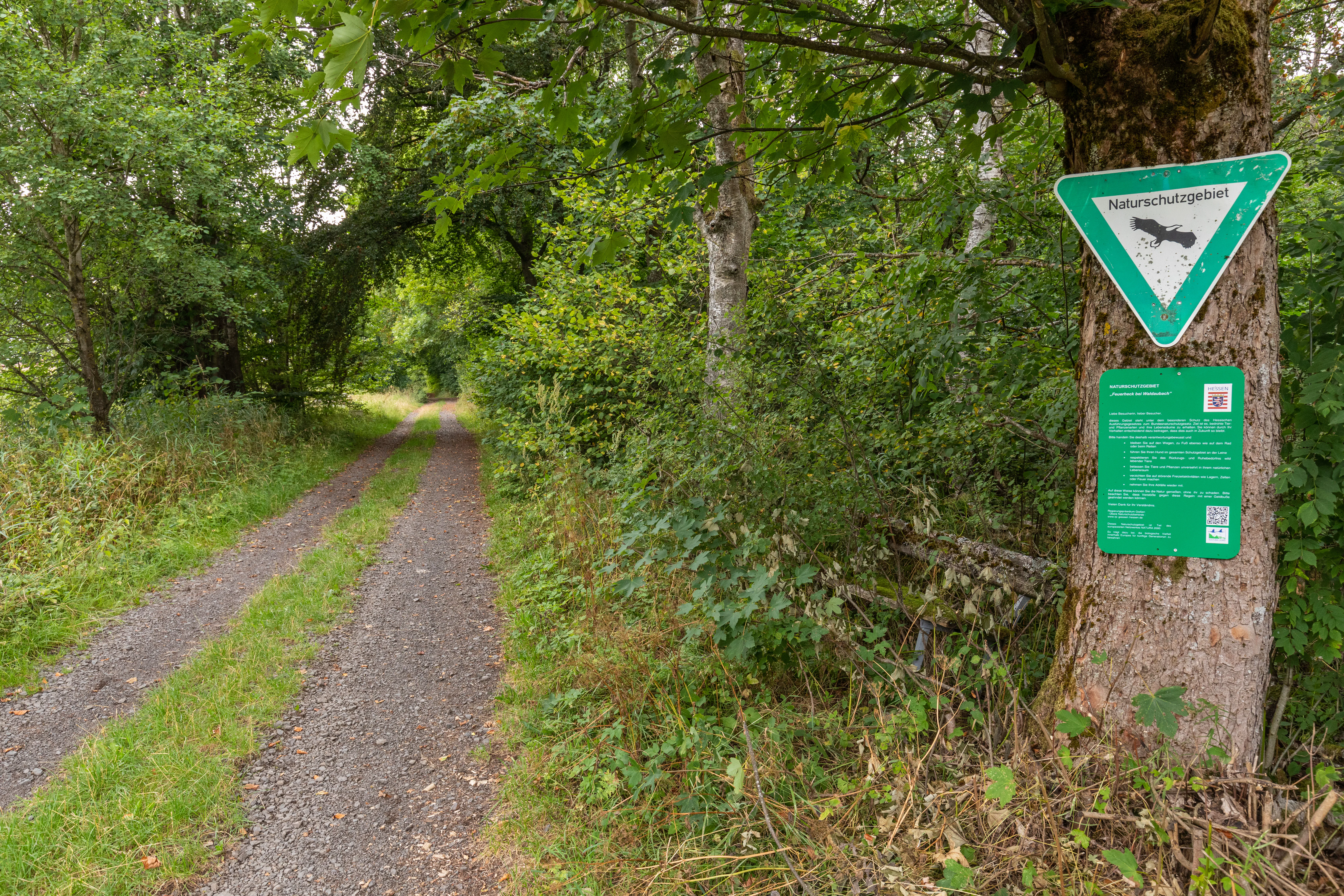
A green triangular Naturschutzgebiet nature reserve sign attached to a tree trunk beside a gravel forest path.
A nature reserve sign at the edge of the forest in Feuerheck bei Waldaubach.

Feuerheck bei Waldaubach wildlife and species highlights

The wildlife value of Feuerheck bei Waldaubach rests on three main pillars: its rich butterfly fauna, its breeding woodland bird community, and the set of specialized moth species associated with old deciduous trees. Across the meadow patches, closed forest, and edge zones, observers have documented more than 115 butterfly species, an exceptional count for such a small reserve and an indication of how the structural mosaic supports insect diversity.

Among the notable invertebrate species recorded are the scarce copper (Lycaena virgaureae), the wych elm carpet (Venusia blomeri), and the maple carpet (Nothocasis sertata), the last associated particularly with mature broadleaf trees. This moth fauna reflects the importance of retaining old-growth broadleaf forest as a habitat resource.

For birds, the most significant record is of the woodcock (Scolopax rusticola), which has been confirmed breeding in the reserve. As a ground-nesting, damp-forest specialist that depends on quiet, well-structured woodland, woodcock presence is a strong indicator of the reserve's suitability as undisturbed breeding habitat. Together, the moth, butterfly, and breeding-bird records give the reserve a focused, ecologically meaningful wildlife profile rather than a broad but shallow list of general forest species.
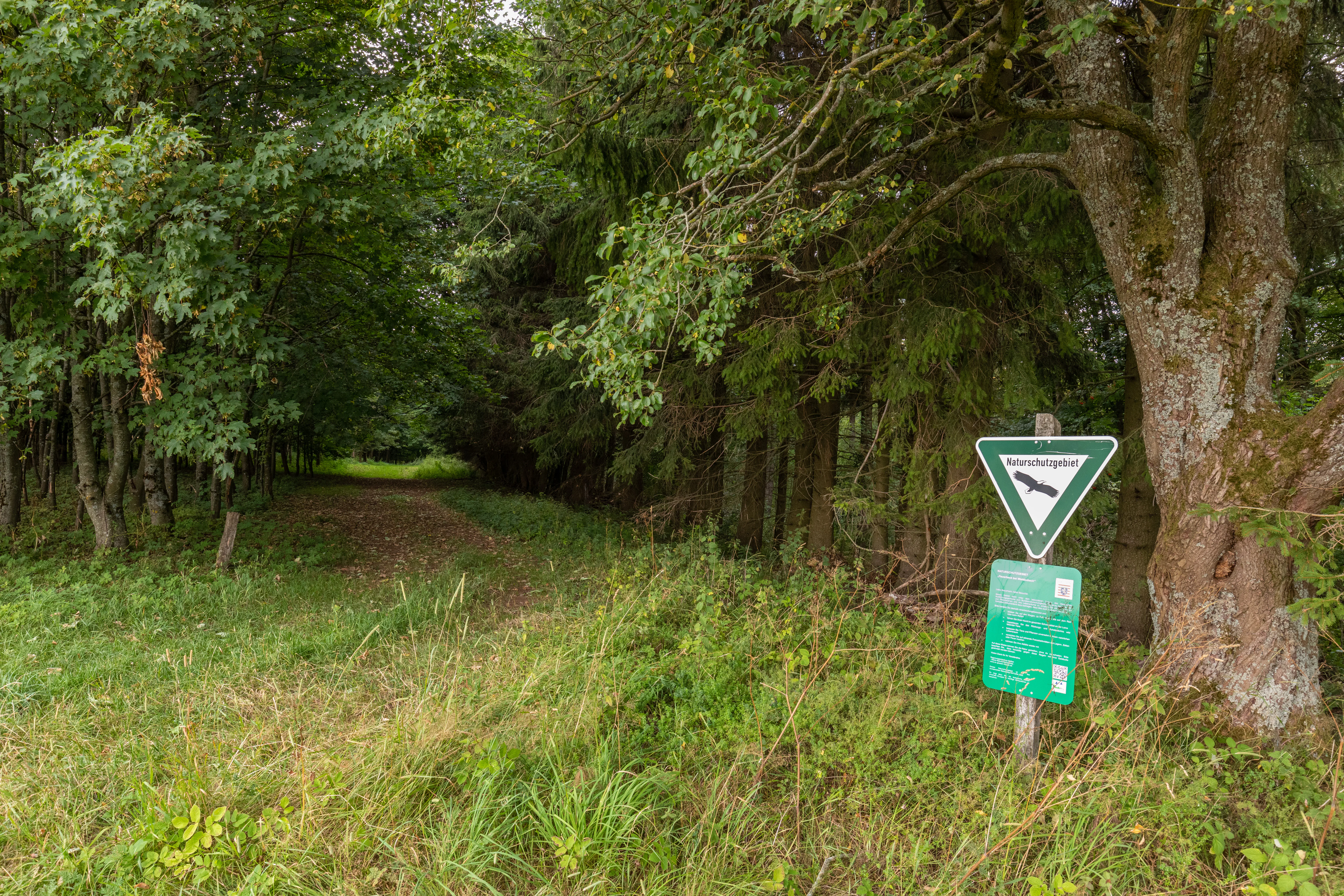
A green triangular nature reserve sign mounted on a post next to a large tree at the edge of a deciduous forest path.
A nature reserve sign marks the entrance to the forest at Feuerheck bei Waldaubach.

Feuerheck bei Waldaubach conservation status and protection priorities

Feuerheck bei Waldaubach is more than a local nature protection area, because its location within both the Hoher Westerwald FFH site and the matching European bird protection area ties it into transnational conservation networks. Its IUCN management category IV reflects its role as a habitat and species management area, and its designation under Hessian nature conservation law in 1984 gave it a long-term legal foundation.

The 2013 management plan for the FFH area formalizes the conservation approach: Feuerheck is managed for natural forest development, without ongoing forestry intervention. This non-intervention strategy preserves the structural and microclimatic conditions that underpin its rare plant communities, its high butterfly species count, and its breeding woodcock population. In the wider context, the reserve contributes to ecological connectivity between adjacent protected areas such as Waldaubacher Hecke bei Rabenscheid, Rabenscheider Holz, and Bermershube bei Heisterberg, strengthening the conservation value of the entire Hoher Westerwald upland.

Top sights and standout views in Feuerheck bei Waldaubach

Feuerheck bei Waldaubach stands out as a textbook example of a small but ecologically dense Hessian upland forest reserve. Its combination of high elevation, heavy rainfall, and varied soils produces a far more complex habitat picture than the modest 24-hectare size would suggest. More than 115 documented butterfly species, a breeding woodcock population, and several rare woodland moths underline its biodiversity value. The reserve is strengthened further by its placement within the larger Hoher Westerwald FFH and bird protection area, which makes it a meaningful component of a wider European conservation network rather than an isolated local site.


Monthly climate preview

Long term representative point averages for monthly temperature and precipitation patterns

Feuerheck bei Waldaubach Climate Normals and Annual Temperature Rhythm

Feuerheck bei Waldaubach exhibits a measured annual temperature and precipitation rhythm across twelve recorded climatological months. Examining the complete monthly climate profile provides deeper insight into long term averages for representative coordinate elevations.
Annual mean9 °C
0 °C19 °C
Jan
Feb
Mar
Apr
May12°
Jun16°
Jul19°
Aug18°
Sep14°
Oct
Nov
Dec
Warmest month
July

18.5 °C

Coolest month
January

-0.4 °C

Wettest month
December

2.5 mm/day

Driest month
April

1.6 mm/day

Park location guide

Geography guide, regional context, and park location map for Feuerheck bei Waldaubach

Feuerheck bei Waldaubach park geography, regions, and map view in Germany

Understand where Feuerheck bei Waldaubach sits in Germany through a broader geographic reading of the surrounding landscape, nearby location context, and its mapped position within the national park landscape.

How Feuerheck bei Waldaubach fits into Germany

Germany is a federal republic in Western and Central Europe with a population of over 83 million across sixteen constituent states. It is Europe's largest economy by nominal GDP and a major global exporter and importer. The capital is Berlin, and the country borders Denmark, Poland, Czech Republic, Austria, Switzerland, France, Luxembourg, Belgium, and the Netherlands.

Wider geography shaping Feuerheck bei Waldaubach in Germany

Germany is located in Western and Central Europe, spanning 357,022 km². It borders Denmark to the north, Poland and the Czech Republic to the east, Austria and Switzerland to the south, and France, Luxembourg, Belgium, and the Netherlands to the west. The country has coastlines on the Baltic Sea and North Sea to the north, with the Alps located in the southern region.

Map view of Feuerheck bei Waldaubach

Use this park location map to pinpoint Feuerheck bei Waldaubach in Germany, understand its exact geographic position, and read its mapped placement within the surrounding landscape more clearly.

Pigeon | © OpenStreetMap contributors

Location context for Feuerheck bei Waldaubach

Hessen

Visualizing the high-elevation deciduous forest mosaic and habitat patterns

Feuerheck bei Waldaubach Photos and Landscape Scenery

Visual documentation of Feuerheck bei Waldaubach reveals the dense upland canopy, mosaic meadows, and varied soil moisture conditions that define the reserve. Examining protected area imagery provides a clear sense of the terrain, forest structure, and specialized habitats found across the high plateau.

A wide view of a grassy meadow with a dirt path running along the left side, bordered by a dense line of trees under a cloudy sky.

Top-down view of a bright orange Scarce Copper butterfly with dark wing borders, perched on a small cluster of white flowers.

A close-up view of a tall, yellow monkshood plant with pale yellow flowers blooming on a central stalk, set against a background of grey rocks and sparse green vegetation.

A green triangular Naturschutzgebiet nature reserve sign attached to a tree trunk beside a gravel forest path.

A green triangular nature reserve sign mounted on a post next to a large tree at the edge of a deciduous forest path.

A dirt trail winds through a dense deciduous forest in Germany with lush green canopy and leaf covered ground.

Park atlas

Compare adjacent forest reserves and protected landscapes across the German central highlands.

Parks Near Feuerheck bei Waldaubach and Protected Areas of the Surrounding Upland Region

Compare Feuerheck bei Waldaubach with other protected areas and forest reserves located throughout the surrounding Hoher Westerwald uplands. Examining nearby parks provides essential regional context for understanding upland forest habitats, moisture gradients, and conservation networks.
A soft watercolor painting showing green rolling hills in the foreground and faded purple and yellow mountain silhouettes against a white background.
Nature reserveRhineland-Palatinate
About 2.1 km away#1 closest

West

Fuchskaute Nature Reserve: Topographic Atlas and Protected Landscape Overview

Highland basalt summit of the Westerwald range in Rhineland-Palatinate

Fuchskaute represents a primary geographic landmark and nature reserve in the Hoher Westerwald. The site features an ancient, erosion-resistant basalt cap that supports rare upland heaths and species-rich meadows, distinct from the surrounding Devonian sediments. Our atlas data tracks its complex overlapping conservation status and provides a clear view of its summit plateau and surrounding hydrographic networks.

Area
0.402 km²
Established
1984
Relief
Mountain
Climate
Temperate
A watercolor illustration of a forest edge with trees, mossy rocks, and ferns, featuring a soft, bright, and airy color palette.
Nature reserveHessen
About 2.2 km away#2 closest

North

Rabenscheider Holz Nature Reserve: Protected Landscapes and Stream Valleys in Hessen

Westerwald upland terrain and diverse woodland habitats

Rabenscheider Holz preserves a vital cross-section of Westerwald habitats, integrating mature broadleaf forests and traditionally managed grasslands. This nature reserve serves as an ecological anchor within the Ketzerbach stream valley, maintaining important woodland and meadow biodiversity in the state of Hessen.

Area
0.573 km²
Established
1994
IUCN
IV
Watercolor painting of a soft, hazy landscape featuring gentle green hills, clusters of trees, and open fields against a white background.
Nature reserveHessen
About 2.3 km away#3 closest

Southeast

Bermershube bei Heisterberg Protected Area: Geography and Landscape Atlas

Nature reserve in the Hoher Westerwald region of Hessen

Located in the Lahn-Dill district, Bermershube bei Heisterberg represents a concentrated mosaic of upland natural features. The protected landscape combines deciduous slope forests with spring-fed wetlands and meadows, creating an essential ecological corridor within the Hoher Westerwald plateau. Detailed geographic insights reveal the interplay between the Amdorf brook drainage and the surrounding undisturbed forest ecosystems.

Area
0.449 km²
Established
1984
IUCN
IV
Relief
Upland
A horizontal watercolor painting depicting a soft, green landscape with a winding stream through a flowery meadow and forested hills in the background.
Nature reserveHessen
About 3.4 km away#4 closest

Southeast

Die Heck bei Hohenroth Nature Reserve: Hessen Protected Forest and Geography

High-elevation woodland habitats in the Hoher Westerwald

Located in the Lahn-Dill district, Die Heck bei Hohenroth provides a specialized look at Mittelgebirge ecology. The reserve functions as a node within European conservation networks, protecting a mosaic of wet and dry forest patches that support rare lichens, fungi, and native bird populations across its rolling upland terrain.

Area
0.204 km²
Established
1998
IUCN
IV
A soft, painterly watercolor illustration of a rolling green landscape with a gentle stream or wetland area in the foreground and rounded hills in the background.
Nature reserveHessen
About 3.8 km away#5 closest

Northeast

Aubachtal bei Rabenscheid Nature Reserve: Mapped Geography and Protected Area Data

A primary stream-valley habitat within the Hessen region

Aubachtal bei Rabenscheid offers a detailed look at a high-quality nature reserve in the Lahn-Dill-Kreis area of Hessen. The landscape is defined by the narrow valley of the Aubach, which supports a complex mosaic of wet meadows, alder swamp woodlands, and sedge mires. This site functions as a significant ecological refuge, contributing to the broader European network of protected areas through its distinct biodiversity and clean-water stream ecosystems.

Area
0.63 km²
Established
1984
IUCN
IV
Relief
Upland
Watercolor painting of a soft, hazy landscape featuring rolling green hills, distant mountains, and water in the foreground.
Nature reserveWesterwaldkreis
About 4.4 km away#6 closest

Southwest

Breitenbachtalsperre Nature Reserve: Geography and Protected Habitat Mapping in Westerwaldkreis

Managed wetland and reservoir landscape in western Germany

Breitenbachtalsperre protects an important reservoir ecosystem, including shallow margins and wet meadows near Waigandshain. This nature reserve provides a focused look at habitat management in the Westerwald, where stream-fed waters sustain diverse plant societies and wildlife in a compact, protected basin.

Area
0.47 km²
Established
1988
IUCN
IV
Nature reserveRheinland-Pfalz
About 6.7 km away#7 closest

South

Wacholderheide bei Westernohe Nature Reserve Protected Area Atlas and Geographic Map Context

Juniper heathland mosaic in the German Westerwald region

Spanning 14 hectares, Wacholderheide bei Westernohe acts as a vital protected pocket of open heathland framed by dense spruce forests. The reserve supports a specialized community of arnica, common heather, and juniper, sustained by decades of consistent grazing and mechanical mowing that define its unique regional character.

Area
0.14 km²
Established
1967
IUCN
IV
Protected areaNordrhein-Westfalen
About 10 km away#8 closest

Northwest

Wälder und Wiesen bei Burbach und Neunkirchen: Protected Area and Regional Geography

High Westerwald upland forests and mountain meadow mosaic

Situated across the tri-border area of North Rhine-Westphalia, this protected zone sustains a rare habitat combination of beech-dominated slopes and extensive montane grasslands. The basalt-influenced terrain supports specialized bird breeding populations, making the area a distinctive feature within the broader context of the central German uplands.

Area
46.546 km²
Established
2001
Relief
Upland
Climate
Temperate

Common questions about visiting, size, designation, and location context for Feuerheck bei Waldaubach

Feuerheck bei Waldaubach FAQs for park facts, access, geography, and protected area context

Find quick answers about Feuerheck bei Waldaubach, including protected-area facts, park geography, trail and visitor context, and how the park fits into its surrounding country and regional landscape.
MoriAtlas Explorer

Continue Your Protected Areas Search Across the Global Atlas

Deepen your exploration by continuing the structured search for national parks and protected areas worldwide. Utilize the comprehensive filtering capabilities to compare different conservation landscapes and refine your understanding of global park geography. Discover more about the distribution and characteristics of protected natural areas.

Global natural geography