
Mori Atlas logo
Nature reserveFinkenbachtal bei Finkenbach

A mapped exploration of meandering brook corridors, gallery forests, and species rich floodplain meadows in southern Hesse

Finkenbachtal bei Finkenbach Nature Reserve: Protected Stream Valleys in the Odenwald Highlands

(Naturschutzgebiet Finkenbachtal bei Finkenbach)

The Finkenbachtal bei Finkenbach nature reserve protects a near natural, 1,500 meter stretch of the Finkenbach stream within the Southern Dissected Sandstone Odenwald. This area showcases a distinct geographic contrast between the shaded, meandering brook corridor and the open wet meadows of the floodplain near the Hörlenbach confluence. Situated within the larger Geo Naturpark Bergstraße Odenwald, the landscape offers a clear view of low mountain valley conservation and stream system connectivity.

nature reservebrook valleyOdenwaldSandstone Odenwaldwet meadowsmeandering stream
A stylized digital illustration showing a winding blue river flowing through a lush green valley toward a distant waterfall and rocky mountains, framed by foreground trees and ferns.

Finkenbachtal bei Finkenbach

Nature reserve

Park overview

Structured park overview, official facts, and landscape profile for Finkenbachtal bei Finkenbach

Finkenbachtal bei Finkenbach park facts, protected area profile, and essential visitor context

Review the core facts for Finkenbachtal bei Finkenbach, including designation, size, terrain, visitor scale, habitats, and operating context in one park-focused overview.

About Finkenbachtal bei Finkenbach

Finkenbachtal bei Finkenbach is a compact, ecologically focused nature reserve in the southern Odenwald of Hesse. Although small in size at roughly 27.6 hectares, it protects a disproportionately rich corridor of valley landscape, following the Finkenbach stream south of the village of Finkenbach for about 1,500 meters.

The valley belongs to the natural region known as the South German Sandstone Odenwald, where gently dissected ridges and narrow stream valleys create characteristic mosaic habitats. In this reserve the landscape is shaped by the Finkenbach itself, whose near-natural, meandering course is lined by gallery forest and bordered by open meadows that have long been managed as hay land and pasture. Where the Hörlenbach joins from the east, north of the Hörlenbachskopf, additional open floodplain meadows extend the protected habitat complex.

Administratively, the reserve straddles a meaningful boundary. Its eastern side falls within the Odenwald district and the city of Oberzent, while its western side belongs to the municipality of Wald-Michelbach in the Bergstraße district. The Finkenbach itself marks part of this district boundary, giving the valley an additional cross-jurisdictional conservation role. The western edge of the protected area runs along the state road L 3119, and the valley ends downstream at a trout pond facility that visually closes the protected stretch.

The reserve is fully embedded in broader conservation frameworks. It lies within the Geo-Naturpark Bergstraße-Odenwald, which promotes the area's geological and cultural landscape values, and it forms part of the FFH conservation site Finkenbachtal und Hinterbachtal, which extends protection to almost the entire course of the Finkenbach. Together these designations underline the valley's value as a continuous brook corridor rather than an isolated patch of habitat, connecting wet meadows, gallery forest, and stream into a single functioning system.

Quick facts and research context for Finkenbachtal bei Finkenbach

Finkenbachtal bei Finkenbach is a Hessian nature reserve, established on 24 November 1981 under registration number 1431011 and recorded in the World Database on Protected Areas as WDPA ID 81666. It covers roughly 27.6 hectares and lies within the Southern Dissected Sandstone Odenwald natural region.

The reserve crosses the administrative boundary between the Bergstraße district and the Odenwald district, with the Finkenbach itself forming part of that boundary. It is part of the Geo-Naturpark Bergstraße-Odenwald and lies entirely within the FFH site Finkenbachtal und Hinterbachtal, linking brook, floodplain meadows, and gallery forest into a single protected landscape unit.

Protection and recognition

Examine terrestrial protection scope, official designation history, and records

Finkenbachtal bei Finkenbach Protection Status and Designation Records

Finkenbachtal bei Finkenbach maintains a documented terrestrial protection scope within the global protected area registry. Official designation records organize structural management details and international recognition data for comprehensive conservation research.

Protection details

Protection scope
Terrestrial
Transboundary protection
No
WDPA ID
81666
Park context

Deeper park guide and search-rich context for Finkenbachtal bei Finkenbach

Finkenbachtal bei Finkenbach history, landscape, wildlife, and travel context

Explore Finkenbachtal bei Finkenbach through its history, landscape character, ecosystems, wildlife, conservation priorities, cultural context, and seasonal travel timing in a structured park guide built for atlas discovery and search intent.

Why Finkenbachtal bei Finkenbach stands out

Finkenbachtal bei Finkenbach is best known for its ecologically valuable stretch of the Finkenbach floodplain, where a near-natural, meandering brook is flanked by intact gallery forest and open, species-rich wet meadows. The defining feature is the combination of flowing water, intact bankside vegetation, and traditionally open floodplain meadows that remain in agricultural use, making the valley a compact example of a protected sandstone-Odenwald stream corridor in southern Hesse.
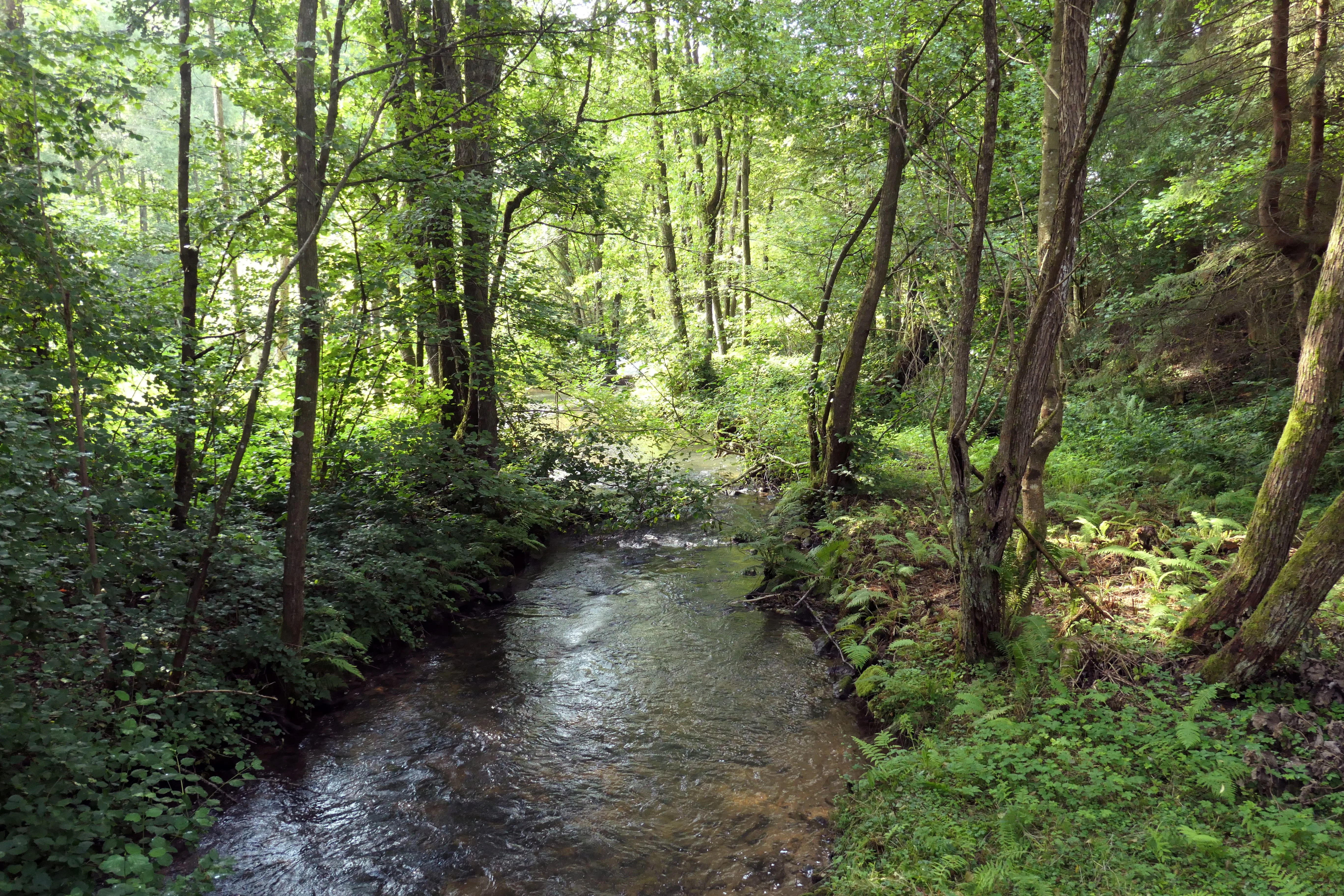
A small, narrow river flows through a dense, green forest with sunlight filtering through the trees, highlighting ferns and deciduous woodland vegetation on the banks.
The Finkenbach river flowing through the forested landscape of the Finkenbachtal nature reserve.

Finkenbachtal bei Finkenbach history and protected-area timeline

The Finkenbachtal bei Finkenbach was formally placed under nature protection on 24 November 1981, with the designation recorded under the Hessian registration number 1431011. The protected area is today listed in the World Database on Protected Areas under WDPA ID 81666.

Its designation responded to the ecological value of the Finkenbach floodplain south of Finkenbach, securing a stretch of near-natural brook, intact bankside vegetation, and species-rich wet meadows before these habitats could be further altered by land-use change. The reserve's later inclusion in the larger FFH site Finkenbachtal und Hinterbachtal extended recognition of the valley's importance within the European network of protected nature sites.

Finkenbachtal bei Finkenbach landscape and geographic character

The landscape of Finkenbachtal bei Finkenbach is a narrow, north to south oriented brook valley in the heart of the Odenwald. It belongs to the Southern Dissected Sandstone Odenwald, where layered sandstone bedrock, gentle relief, and dense forest cover combine with small, fast-flowing streams to produce a classic low-mountain valley scenery.

Within the reserve, the dominant features are the Finkenbach itself and the open meadows of its floodplain. The brook meanders through the valley floor, lined with tall gallery forest that creates a shaded green corridor. West of the stream the valley rises toward the slopes used by the village and the L 3119 state road, while east of the brook the land opens into the floodplain meadows of the Hörlenbach tributary. Downstream, the protected stretch ends where a small trout pond facility marks the transition into a more modified valley section.

The visual character of the reserve is defined by this contrast between narrow wooded brook corridor and open, sunlit wet meadows. Seasonal variation in water level and meadow management produces changing impressions through the year, from high spring flows along the meanders to the dry, flowering hay meadows of late summer. The valley reads as a textbook example of a small-scale Odenwald brook landscape in southern Hesse.
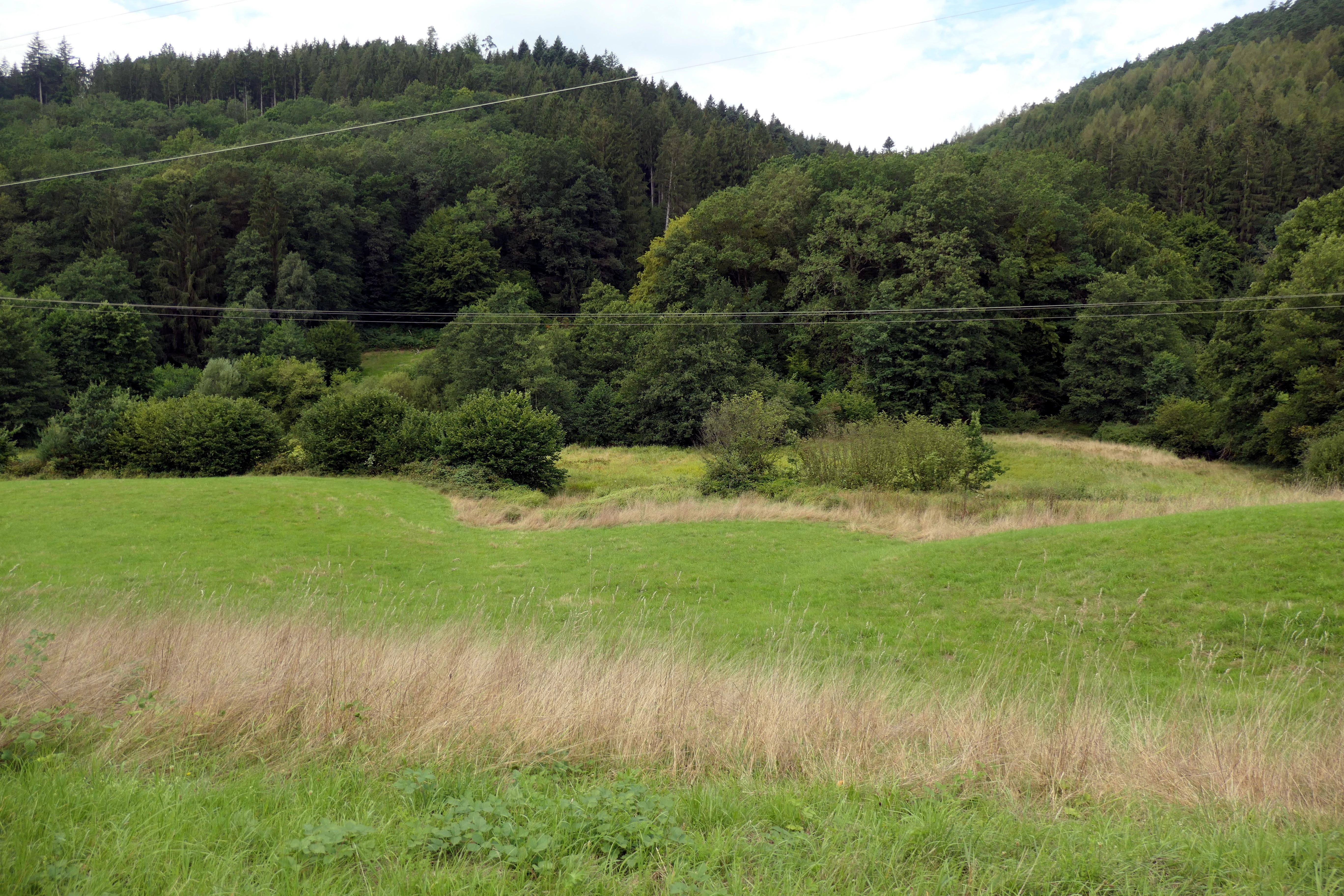
A wide shot of a green valley landscape with tall grasses in the foreground, a meadow, and a dense forest covering the hillside in the background under an overcast sky.
A view of the wet meadows and forested slopes within the Finkenbachtal nature reserve.

Finkenbachtal bei Finkenbach ecosystems, habitats, and plant life

Ecologically, the reserve protects a continuous mosaic of three closely linked habitats: the brook itself, its bankside gallery forest, and the open wet meadows of the floodplain.

The Finkenbach is a small, near-natural, meandering sandstone brook. Its intact bankside vegetation, including alder and willow dominated gallery forest, stabilizes the banks, shades the water, and provides habitat for brook-dwelling invertebrates, amphibians, and fish. The meanders themselves create a varied micro-relief of pools, gravel bars, and undercut banks, supporting the kind of structural diversity typical of unchannelized low-mountain streams.

Around the brook, the floodplain meadows form the second key element. These species-rich wet meadows are maintained through traditional mowing and grazing practices that prevent scrub encroachment and preserve their open character. They harbor a range of moisture-loving plants, including grasses, sedges, and meadow herbs typical of Odenwald low-mountain stream valleys, and they provide important feeding and breeding habitat for insects, amphibians, and ground-nesting birds.

Where the Hörlenbach flows in from the east, the open meadow area expands, broadening the wetland habitat complex. Together with the FFH site Finkenbachtal und Hinterbachtal, the reserve forms part of a longer, ecologically connected brook corridor in the southern Odenwald, linking upper catchment forest with downstream Odenwald stream systems.

Finkenbachtal bei Finkenbach wildlife and species highlights

The wildlife significance of Finkenbachtal bei Finkenbach lies less in rare single species and more in the functioning whole of its brook meadow mosaic.

The clean, near-natural Finkenbach with its intact gallery forest and meandering course provides habitat for typical brook-dwelling fauna, including aquatic invertebrates, small fish populations, and amphibians that depend on cool, oxygen-rich, structurally complex water bodies. The shaded banks and root systems of the alder and willow gallery forest are important refuge zones for these communities and offer shelter during periods of high flow.

The open wet meadows of the floodplain, including the broader expanse where the Hörlenbach joins from the east, support a rich insect fauna typical of unfertilized, traditionally managed low-mountain meadows. This in turn provides feeding opportunities for bats, birds, and other insectivorous species. The combination of water, wet meadow, and adjacent forest edge creates transitional structures that are especially valuable for species that move between aquatic and terrestrial habitats, including amphibians and wetland-associated birds typical of Odenwald stream valleys.

Finkenbachtal bei Finkenbach conservation status and protection priorities

Finkenbachtal bei Finkenbach was placed under nature protection in 1981 to secure an ecologically valuable section of the Finkenbach floodplain, with explicit focus on the near-natural, meandering brook and its species-rich wet meadows. The designation protects the integrity of the stream and its bankside vegetation from further hydrological or land-use alteration, and it preserves the open character of the floodplain meadows that would otherwise be lost to scrub encroachment or intensification.

The reserve is part of the Geo-Naturpark Bergstraße-Odenwald, which frames the valley within a broader landscape of geological and cultural heritage value, and is fully embedded in the FFH site Finkenbachtal und Hinterbachtal. This European-level designation extends habitat protection along nearly the entire course of the Finkenbach, connecting the protected stretch near Finkenbach with the rest of the brook system and reinforcing its role as a coherent, ecologically functional valley rather than an isolated reserve patch.

Because the brook itself marks the boundary between the Bergstraße and Odenwald districts, the site also serves as a cross-jurisdictional conservation unit. Maintaining the valley as a continuous, near-natural corridor requires coordinated management between Wald-Michelbach and the city of Oberzent, and the reserve provides a focus for that cooperation in the southern Hessian Odenwald.

Finkenbachtal bei Finkenbach cultural meaning and human context

The Finkenbach valley south of Finkenbach reflects the long-standing agricultural relationship between Odenwald villages and their local brook valleys. The species-rich wet meadows within the reserve are the product of traditional mowing and grazing practices that have shaped the floodplain landscape for generations, keeping the valley floor open in contrast to the surrounding forested slopes.

The valley also belongs to a broader cultural landscape under the Geo-Naturpark Bergstraße-Odenwald, which recognizes the interplay between sandstone geology, settlement patterns, and land use in shaping the regional identity of the southern Odenwald. The trout pond facility at the downstream end of the protected stretch reflects another aspect of this land-use tradition, linking small-scale aquaculture with the management of the valley's water resources.

Top sights and standout views in Finkenbachtal bei Finkenbach

The strongest features of Finkenbachtal bei Finkenbach are its compact protected valley length of roughly 1,500 meters along the Finkenbach; its near-natural, meandering sandstone brook; and the intact gallery forest that lines the stream. Equally distinctive is the open floodplain landscape, where species-rich wet meadows extend into the valley of the Hörlenbach tributary, creating a broad, sunlit contrast to the shaded brook corridor.

Set within the Southern Dissected Sandstone Odenwald and embedded in the larger FFH site Finkenbachtal und Hinterbachtal, the reserve functions as a coherent, ecologically connected piece of a longer brook system rather than an isolated patch of habitat.

Best time to visit Finkenbachtal bei Finkenbach

The valley reads differently across the year, and the most rewarding visits reflect the seasonal rhythm of its brook and meadows. Late spring and early summer bring full leaf-out in the gallery forest, the highest stream vegetation cover, and the first flowering period in the wet meadows, when marsh plants and meadow herbs are most visible.

Midsummer is the period when the open floodplain meadows are at their most expressive, with mature hay meadows and active insect life along the meadow edges. Late summer and early autumn offer drier, more open views of the valley floor and clearer views of the meandering course of the Finkenbach itself, when lower water levels expose more of the brook's structural detail. Snow cover in winter can thin out the visual density of the gallery forest and reveal the valley's basic landform, while the brook itself remains a continuous, flowing focus throughout the year.

Monthly climate preview

Long term representative point measurements detailing monthly temperature ranges and precipitation

Finkenbachtal bei Finkenbach Climate Normals and Annual Temperature Rhythm

Representative coordinate records show measured monthly temperature variations alongside steady precipitation patterns across the year. Reviewing the complete twelve month profile provides detailed long term climate normals for comparative geographic analysis.
Annual mean10 °C
0 °C20 °C
Jan
Feb
Mar
Apr
May14°
Jun18°
Jul20°
Aug20°
Sep15°
Oct10°
Nov
Dec
Warmest month
July

20.3 °C

Coolest month
January

0.1 °C

Wettest month
July

2.4 mm/day

Driest month
April

1.5 mm/day

Park location guide

Geography guide, regional context, and park location map for Finkenbachtal bei Finkenbach

Finkenbachtal bei Finkenbach park geography, regions, and map view in Germany

Understand where Finkenbachtal bei Finkenbach sits in Germany through a broader geographic reading of the surrounding landscape, nearby location context, and its mapped position within the national park landscape.

How Finkenbachtal bei Finkenbach fits into Germany

Germany is a federal republic in Western and Central Europe with a population of over 83 million across sixteen constituent states. It is Europe's largest economy by nominal GDP and a major global exporter and importer. The capital is Berlin, and the country borders Denmark, Poland, Czech Republic, Austria, Switzerland, France, Luxembourg, Belgium, and the Netherlands.

Wider geography shaping Finkenbachtal bei Finkenbach in Germany

Germany is located in Western and Central Europe, spanning 357,022 km². It borders Denmark to the north, Poland and the Czech Republic to the east, Austria and Switzerland to the south, and France, Luxembourg, Belgium, and the Netherlands to the west. The country has coastlines on the Baltic Sea and North Sea to the north, with the Alps located in the southern region.

Map view of Finkenbachtal bei Finkenbach

Use this park location map to pinpoint Finkenbachtal bei Finkenbach in Germany, understand its exact geographic position, and read its mapped placement within the surrounding landscape more clearly.

Pigeon | © OpenStreetMap contributors

Location context for Finkenbachtal bei Finkenbach

Hesse

Explore protected valley terrain, meandering brook habitats, and floodplain meadow environments.

Finkenbachtal bei Finkenbach Photos and Landscape Scenery Visuals

Visual records illustrate the meandering brook channels, gallery forests, and open wet meadows defining the protected valley floor. Photographic documentation reveals the low mountain terrain and seasonal stream dynamics characteristic of this southern Hesse nature reserve.

A small, narrow river flows through a dense, green forest with sunlight filtering through the trees, highlighting ferns and deciduous woodland vegetation on the banks.

A wide shot of a green meadow in a valley in Hesse, Germany, with a white and green nature reserve sign on the left.

A wide shot of a green valley landscape with tall grasses in the foreground, a meadow, and a dense forest covering the hillside in the background under an overcast sky.

Park atlas

Compare nearby protected landscapes and low-mountain nature reserves in the Odenwald region.

Other Parks Near Finkenbachtal bei Finkenbach and Surrounding Protected Valleys

Browsing other parks near Finkenbachtal bei Finkenbach reveals connected brook valleys and regional protected landscapes across southern Hesse. Evaluating adjacent reserves provides broader context on sandstone stream corridors and local conservation networks.
Watercolor painting of a gentle, rolling green landscape with sparse trees and distant hills on a white background.
Nature reserveHesse
About 5.3 km away#1 closest

Northeast

Jakobsgrund bei Gammelsbach Nature Reserve: Geographic Atlas and Park Boundary Mapping

Protected sandstone valley landscapes in southern Hesse

This nature reserve in the Odenwald hills provides a concentrated example of traditional valley land use. The area features a sharp contrast between dry south-facing slopes and damp, stream-carved lowlands, creating a botanical hotspot within the regional geography of Hesse, Germany.

Area
0.095 km²
Established
1996
IUCN
IV
Relief
Upland
Watercolor painting of soft, rolling green hills and meadows in a minimalist style, set against a light background.
Nature reserveHessen
About 5.8 km away#2 closest

Northwest

Dürr-Ellenbachtal von Wald-Michelbach: Odenwald Nature Reserve and Protected Valley Geography

A historic meadow valley in Hessen, Germany

The Dürr-Ellenbachtal von Wald-Michelbach nature reserve protects an elongated, narrow valley framed by forested ridges in the central Odenwald. This area is defined by its meandering brook, diverse alder stands, and species-rich meadows that sustain significant local biodiversity. As a key Natura 2000 site, it serves as an essential example of protected meadow landscapes and rural mountain terrain within the Bergstraße district.

Area
0.542 km²
Established
1990
IUCN
IV
Relief
Mountain
A watercolor painting depicting a soft-focus, light-colored landscape of rolling green hills, clustered trees, and a gentle stream valley.
Nature reserveHessen
About 6.7 km away#3 closest

West

Eiterbachtal von Wald-Michelbach Nature Reserve in the Central Odenwald Uplands

A protected stream-valley landscape in the Bergstraße district of Hessen

Eiterbachtal von Wald-Michelbach protects a near-natural stream environment characterized by its meandering course, alder-ash gallery forests, and diverse tall-herb meadow communities. This nature reserve provides essential habitat in the southern Odenwald, showcasing the interplay between hydrological stream processes and sandstone forest edges within the Hessen region.

Area
0.473 km²
Established
1983
IUCN
IV
Relief
Upland
A horizontal watercolor painting showing rolling green hills, a winding stream in the foreground, and a single tree on the right.
Protected landscapeRhein-Neckar-Kreis
About 8.2 km away#4 closest

Southwest

Odenwald Protected Landscape: Geography and Regional Mapping in Rhein-Neckar-Kreis

Exploring the characteristic Odenwald mountain terrain and valley systems

This protected landscape encompasses over 6,000 hectares of diverse topography in northern Baden-Württemberg. The terrain features a classic Odenwald relief, defined by narrow V-shaped valley notches, riparian woodlands, and structural mosaics of forest and meadow. Gain insight into the geographic and ecological character of these protected stream catchments and ridgelines.

Area
60.775 km²
Established
1996
IUCN
V
A wide watercolor painting showing rolling green hills and trees with pale pink and yellow hues across a valley landscape.
Nature reserveHessen
About 10 km away#5 closest

North

Rotes Wasser von Olfen Nature Reserve: Protected Wetland and Odenwald Geography

A unique bog and iron-rich stream landscape in Hessen, Germany.

Rotes Wasser von Olfen preserves a rare, small-scale mosaic of transitional bog and wet meadow vegetation within the Odenwald range. This protected site features reddish, iron-rich seepage waters and provides essential habitat for specialized flora and dragonfly populations amidst a surrounding forested mountain landscape.

Area
0.121 km²
Established
1980
IUCN
IV
Relief
Upland
Nature reserveHesse
About 10 km away#6 closest

Northwest

In der Striet bei Vöckelsbach Nature Reserve: Regional Geography and Mapped Protected Landscapes

A compact forest and wetland mosaic in the Odenwald of southern Hesse

The nature reserve In der Striet bei Vöckelsbach is an essential protected area covering four and a half hectares of valley floor. It provides a dense habitat gradient from reeded spring zones through alder forests to mixed deciduous slopes. This record details the park landscape, stream systems, and its integration into the larger Geo Naturpark Bergstraße Odenwald and Natura 2000 protected areas.

Area
0.048 km²
Established
1988
A horizontal watercolor illustration of a soft, rolling landscape with a central winding path or stream, green meadows, distant hills, and foreground trees and flowers.
Nature reserveHesse
About 14 km away#7 closest

North

Gras-Ellenbacher Wiesen Nature Reserve: Protected Valley Basin Geography and Map Overview

Wet meadows and seepage habitats within the Odenwald hills

Situated in a gentle hollow near the Dachsberg and Kirchberg ridges, Gras-Ellenbacher Wiesen represents an essential Hessian nature reserve. This overview highlights the interplay between the Ulfenbach stream, drainage infrastructure, and traditional meadow management that defines this distinct sandstone upland protected landscape.

Area
0.241 km²
Established
1981
IUCN
IV
Relief
Upland
A wide watercolor illustration showing a river curving through a grassy valley with trees and hills in the background.
Nature reserveHessen
About 14 km away#8 closest

Northwest

In der Erbach bei Mörlenbach Nature Reserve: Protected Odenwald Stream Valley

Regional geography and habitat mapping in southern Hessen

The In der Erbach bei Mörlenbach nature reserve preserves a well-defined side-valley ecosystem within the broader Odenwald landscape. Its protected boundaries encompass a moisture-rich corridor featuring wet meadows, reedbeds, and forest edges that exemplify the traditional cultural geography of the Weschnitz river basin in southern Germany.

Area
0.197 km²
Established
1997
IUCN
IV
Relief
Upland

Common questions about visiting, size, designation, and location context for Finkenbachtal bei Finkenbach

Finkenbachtal bei Finkenbach FAQs for park facts, access, geography, and protected area context

Find quick answers about Finkenbachtal bei Finkenbach, including protected-area facts, park geography, trail and visitor context, and how the park fits into its surrounding country and regional landscape.
MoriAtlas Explorer

Continue Your Protected Areas Search Across the Global Atlas

Deepen your exploration by continuing the structured search for national parks and protected areas worldwide. Utilize the comprehensive filtering capabilities to compare different conservation landscapes and refine your understanding of global park geography. Discover more about the distribution and characteristics of protected natural areas.

Global natural geography