Mori Atlas logo
Protected areaForêt classée de Divo

Examining the ecological boundaries and terrain of a significant Guinean forest reserve

Forêt classée de Divo: A Documented Protected Landscape in Southwestern Ivory Coast

Forêt classée de Divo represents a key classified forest reserve in the Gôh-Djiboua region of southwestern Ivory Coast. This site documents the transition of Guinean-type rainforest landscapes, characterized by gently rolling terrain and seasonal streams, into areas influenced by modern land-use competition. Analyzing the current spatial extent of this protected area offers insight into forest conservation dynamics within the West African regional geography.

classified foresttropical rainforesthumid forestGuinean forestlowland forestforest reserve

Forêt classée de Divo

Protected area

Park overview

Structured park overview, official facts, and landscape profile for Forêt classée de Divo

Forêt classée de Divo park facts, protected area profile, and essential visitor context

Review the core facts for Forêt classée de Divo, including designation, size, terrain, visitor scale, habitats, and operating context in one park-focused overview.

About Forêt classée de Divo

The Forêt classée de Divo is a state-classified forest reserve in the département de Divo, in the Gôh-Djiboua region of southwestern Côte d'Ivoire, situated not far from the village of Datta. It belongs to the broader network of forêts classées that constitute the country’s official forest heritage, a system with roots in the French colonial period but still central to Côte d'Ivoire's approach to managing and protecting wooded areas.

The reserve was first established in 1928 as the Réserve de Divo, then formally classified through an arrêté a few decades into the colonial era. Its boundaries were later adjusted in 1932, and by 1978 the forest figured in the national listing of classified state forests with a reported extent of around 7,350 hectares. Under a more recent framework set by decree in 2021, Divo appears among classified forests of the private state forest domain at a scale of 2,000 hectares, eligible for time-limited exploitation under defined conditions rather than treated purely as a strict reserve.

Ecologically, the forest sits within the low-relief, humid zone characteristic of Côte d'Ivoire's southwest. The terrain is broadly flat with gentle undulations rather than dramatic landforms, and the hydrology of the area is shaped by seasonal watercourses (cours d'eau saisonniers). These streams sustain moisture in the understory and support the growth of dense vegetation, giving the classified forest its characteristically thick, humid forest flora.

Beyond its physical setting, the reserve's present identity is inseparable from the land-use pressures pressing in around it. Agricultural expansion, especially cocoa and rubber cultivation, illegal timber harvesting, bush fires, and the outward spread of rural habitation have all contributed to substantial deforestation within and around the classified perimeter. The Forêt classée de Divo therefore stands both as a surviving example of classified humid forest in southwestern Côte d'Ivoire and as an illustration of how these long-standing reserves continue to negotiate their future between protection, rural livelihoods, and state concession frameworks.

Quick facts and research context for Forêt classée de Divo

The Forêt classée de Divo is a state-designated classified forest reserve located in the département de Divo in southwestern Côte d'Ivoire, within the Gôh-Djiboua region. It was originally established as the Réserve de Divo by decree on 3 September 1928, with its boundaries later adjusted by an arrêté of 20 December 1932.

In the 1978 listing of Côte d'Ivoire's classified state forests, the reserve was recorded at around 7,350 hectares. A later framework, set by decree in 2021, lists the Forêt classée de Divo among classified forests of the private state forest domain at a surface of 2,000 hectares, eligible for time-limited concession under specified conditions.

Protection and recognition

Documented terrestrial protection scope, designation year, and official recognition records

Forêt classée de Divo Protection Status and Conservation History

Historical records establish the official protection status and terrestrial management scope of Forêt classée de Divo following its 1928 designation. Structured conservation data tracks recorded protection milestones and administrative frameworks without international recognition sources.

Protection details

Protection scope
Terrestrial
Designated year
1928
Transboundary protection
No
Park context

Deeper park guide and search-rich context for Forêt classée de Divo

Forêt classée de Divo history, landscape, wildlife, and travel context

Explore Forêt classée de Divo through its history, landscape character, ecosystems, wildlife, conservation priorities, cultural context, and seasonal travel timing in a structured park guide built for atlas discovery and search intent.

Why Forêt classée de Divo stands out

The Forêt classée de Divo is best known as a classified fragment of Guinean rainforest in southwestern Côte d'Ivoire that has endured despite severe agricultural and settlement pressure. Its profile is defined by low, gently undulating terrain, seasonal streams that feed a moist understory, and vegetation dense enough to reflect the once-broader humid forest cover of the region. Equally defining is its modern conservation story: a long-established reserve that has been substantially reduced in effective forest cover over recent decades, making it a notable case study of how classified forests in Côte d'Ivoire interact with cocoa, rubber, and rural expansion pressures.

Forêt classée de Divo history and protected-area timeline

The forest was first placed under state protection during the colonial period, initially known as the Réserve de Divo. On 3 September 1928, an arrêté formally classified the area, establishing it as part of what would become Côte d'Ivoire's enduring network of forêts classées. Its boundaries were modified a few years later by an arrêté dated 20 December 1932, reflecting the early administrative adjustments that shaped many of the country's classified forests.

By 1978, the reserve appeared in the official list of classified state forests of Côte d'Ivoire with a recorded extent of around 7,350 hectares, a figure that captures its scale at that point in the post-colonial forestry record.

In 2021, a decree set out a general framework for the management of classified forests belonging to the private state forest domain, under which the Forêt classée de Divo is listed among forests eligible for concessions of limited duration under defined conditions. This arrangement marks a shift toward a more concession-based approach to managing some classified forests in the country, while still preserving the reserve's protected status within the national forest estate.

Forêt classée de Divo landscape and geographic character

The Forêt classée de Divo occupies a low-relief landscape typical of southwestern Côte d'Ivoire, where elevation changes are subtle and the terrain reads as broadly flat with only gentle undulations. There are no prominent peaks, cliffs, or dramatic landforms; instead, the scenery is shaped by rolling ground, patches of dense vegetation, and the textures of a humid forest understory.

The area's hydrology is dominated by seasonal streams rather than large permanent rivers. These watercourses carry water during the rainy periods of the year, sustaining moisture in the forest floor and contributing to the dense vegetation that defines the reserve. Outside the wetter zones, the transitional edges between forest, farmland, and rural settlement shape much of the contemporary visual character of the landscape, particularly where agricultural encroachment has thinned or fragmented the original forest cover.

Forêt classée de Divo ecosystems, habitats, and plant life

Ecologically, the Forêt classée de Divo belongs to the Guinean forest zone of West Africa, a humid forest environment characterized by closed canopy, dense understory, and the kind of moisture-loving plant communities that thrive where seasonal streams keep the ground well supplied with water. Its vegetation reflects the conditions typical of southwestern Côte d'Ivoire, where rainfall patterns and humidity support thick, layered forest growth.

While the reserve's current condition reflects significant disturbance, its ecological role remains connected to the preservation of a humid forest patch within a wider agricultural landscape. The presence of streams that feed the understory gives the classified forest a particular capacity to retain moisture-loving vegetation, distinguishing its ecological conditions from drier, more open forests elsewhere in the country.

Forêt classée de Divo wildlife and species highlights

The source material does not provide sufficient detail on the specific fauna of the Forêt classée de Divo to support a detailed wildlife profile. While the reserve forms part of a humid forest environment in southwestern Côte d'Ivoire that would historically have supported typical West African forest wildlife, the available text focuses on land cover, agricultural pressures, and administrative history rather than on species composition.

Forêt classée de Divo conservation status and protection priorities

The Forêt classée de Divo is part of Côte d'Ivoire's official forest heritage and is administered through the country's framework for forêts classées. Its conservation significance lies less in its scale than in what it represents: a surviving classified fragment of humid forest within a region that has experienced extensive transformation.

Its conservation profile is dominated by threats rather than by a long list of achievements. In recent years, the reserve has experienced substantial deforestation driven by agricultural expansion, especially the cultivation of cocoa and rubber (hévéa), by illicit timber extraction, by bush fires, and by the spread of human settlement into and around the classified perimeter. These pressures have meaningfully reduced the forest's effective cover and fragmentation across the reserve and its surroundings.

At the same time, the reserve's inclusion in the 2021 framework for the management of classified forests of the private state forest domain, including the possibility of time-limited, conditional concessions, signals an ongoing effort to reconcile protection goals with sustainable exploitation and revenue frameworks.

Top sights and standout views in Forêt classée de Divo

A classified state forest reserve dating to 1928, with boundaries later revised in 1932, situated in the département of Divo in southwestern Côte d'Ivoire near the village of Datta. The reserve lies in a setting of low, gently undulating terrain crossed by seasonal streams that help sustain the humid vegetation typical of the Guinean forest zone.

Although it was recorded at around 7,350 hectares in 1978 and later listed at 2,000 hectares under the 2021 management framework, the Forêt classée de Divo is defined as much by the pressures it faces as by its protected status. Cocoa and rubber cultivation, illegal logging, bush fires, and expanding human settlement have driven significant deforestation, making the reserve a striking case where a long-standing classified forest continues to negotiate its ecological future against strong land-use competition.

Best time to visit Forêt classée de Divo

Seasonal context for the Forêt classée de Divo is best understood through the annual rhythm of Côte d'Ivoire's southwestern humid zone, where rainfall supports the streams and understory moisture that characterize the forest. Visiting during the wetter part of the year, when streams are flowing and vegetation is at its most lush, gives a stronger sense of the reserve's humid forest character, while drier periods may make forest edges and surrounding farmland more visible but reduce the visual density of the vegetation.
Monthly climate preview

Long-term representative measurements of monthly temperature and precipitation patterns

Forêt classée de Divo Climate Normals and Annual Temperature Rhythm

Representative coordinate records show recorded mean monthly temperatures ranging between 24.51 °C and 28.14 °C alongside varying precipitation rates across the twelve-month cycle. Reviewing the full monthly sequence clarifies the complete baseline climatology recorded for this protected area.
Annual mean26 °C
25 °C28 °C
Jan27°
Feb28°
Mar28°
Apr27°
May26°
Jun25°
Jul25°
Aug25°
Sep25°
Oct26°
Nov26°
Dec27°
Warmest month
February

28.1 °C

Coolest month
July

24.5 °C

Wettest month
June

6.9 mm/day

Driest month
January

0.7 mm/day

Park location guide

Geography guide, regional context, and park location map for Forêt classée de Divo

Forêt classée de Divo park geography, regions, and map view in Ivory Coast

Understand where Forêt classée de Divo sits in Ivory Coast through a broader geographic reading of the surrounding landscape, nearby location context, and its mapped position within the national park landscape.

How Forêt classée de Divo fits into Ivory Coast

Ivory Coast, officially the Republic of Côte d'Ivoire, is a West African country with a coastline on the Gulf of Guinea. It gained independence from France in 1960 and is now a presidential republic. The country is a major producer of cocoa and coffee, with Abidjan serving as its largest city and economic hub, while Yamoussoukro is the official capital.

Wider geography shaping Forêt classée de Divo in Ivory Coast

Ivory Coast is situated on the southern coast of West Africa along the Gulf of Guinea. It borders Guinea to the northwest, Liberia to the west, Mali to the northwest, Burkina Faso to the northeast, Ghana to the east, and the Atlantic Ocean to the south. The terrain includes coastal plains, interior highlands, and forested regions.

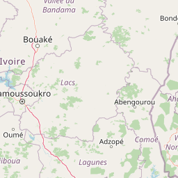
Map view of Forêt classée de Divo

Use this park location map to pinpoint Forêt classée de Divo in Ivory Coast, understand its exact geographic position, and read its mapped placement within the surrounding landscape more clearly.

Pigeon | © OpenStreetMap contributors
Park atlas

Compare regional forest reserves and examine connected conservation geography in southwestern Côte d'Ivoire.

Exploring Parks Near Forêt Classée de Divo and Surrounding Protected Landscapes

Browsing other protected areas near Forêt classée de Divo reveals broader regional forest patterns and contiguous lowland habitats. Comparing adjacent conservation landscapes provides valuable context on humid forest remnants and regional land use pressures.
Nature reserveLôh-Djiboua
About 7.6 km away#1 closest

East

Réserve botanique de Divo: Protected Forest Landscapes and Regional Geography in Lôh-Djiboua

Nature reserve featuring extensive forest restoration projects.

Discover the complex landscape of Réserve botanique de Divo, one of the oldest nature reserves in Côte d'Ivoire. Located in the Lôh-Djiboua region, this protected area represents a transition between remaining secondary forest fragments and agricultural land, serving as a primary site for international tropical forestry restoration efforts.

Area
68.02 km²
Established
1935
Relief
Lowland
Climate
Tropical
A soft watercolor painting of a pastoral landscape with a meandering river in the foreground, clumps of green trees, and layered rolling hills in the background.
Nature reserveIvory Coast
About 45 km away#2 closest

Northeast

Station d'écologie de Lamto: Nature Reserve and Protected Landscape in Ivory Coast

Examining the forest and savanna transition zone along the Bandama River

Station d'écologie de Lamto is a significant nature reserve situated at a unique ecological contact point in central Ivory Coast. This 2,500 hectare protected area encompasses Borassus palm savanna and gallery forest, serving as a landmark site for West African ecological research and the study of forest and savanna mosaic landscapes.

Area
25 km²
Established
1962
IUCN
Ia
Relief
Lowland
National parkIvory Coast
About 81 km away#3 closest

Southeast

Assagny National Park: Ivory Coast's Protected Natural Landscape and Park Boundaries

Explore the mapped terrain and regional geography.

Assagny National Park is a significant protected area in Ivory Coast, functioning as a national park. This entry provides detailed information on its geographic setting, mapping its protected boundaries and surrounding natural landscapes. It serves as a resource for understanding the park's specific landscape character and its contribution to the regional geography of West Africa, offering an atlas-style exploration of its conservation significance.

Area
170 km²
Established
1981
IUCN
II
National parkLagunes
About 90 km away#4 closest

Southeast

Parc national d'Azagny: Protected Coastal Wetlands and Estuarine Terrain in Lagunes

Coastal wetland geography and savanna ecosystems in Côte d'Ivoire

Explore the unique estuarine geography of Parc national d'Azagny, a Ramsar site encompassing a dense mosaic of mangrove swamps, coastal savanna clearings, and tidal waterways. This protected area plays a crucial role in maintaining the ecological stability of the Lagunes region and supports a variety of species within its specialized low-lying habitats.

Area
194 km²
Established
1981
IUCN
II
Relief
Lowland
Nature reserveIvory Coast
About 113 km away#5 closest

Southwest

Forêt classée de Niégré: Mapping the Protected Forest Landscape of Southwestern Ivory Coast

A regional study of forest fragments and Guinean moist forest ecology

Forêt classée de Niégré serves as a focal point for understanding the interplay between protected-area boundaries and agrarian expansion in southwestern Ivory Coast. This geographic profile examines the massif as a remnant of Guinean moist evergreen forest, mapping its transformation from a closed canopy system into a fragmented mosaic that reflects broader regional shifts in land-use and environmental management policy.

Area
925 km²
Established
1937
Relief
Lowland
Climate
Subtropical
National parkAbidjan
About 144 km away#6 closest

Southeast

Banco National Park National Park: Primary Forest Landscape and Abidjan Geography

Explore mapped boundaries and urban conservation.

Banco National Park is a globally significant protected area, uniquely preserving dense primary tropical forest within the urban sprawl of Abidjan, Ivory Coast. This national park offers critical insights into urban conservation, featuring rare tree species and providing essential ecosystem services like water supply and carbon sequestration for the surrounding region. Its landscape, characterized by the Gbangbo River and rare mahogany and avodire trees, forms a vital geographic element within the metropolitan atlas.

Area
30 km²
Established
1953
IUCN
II
Relief
Lowland
A horizontal watercolor painting showing a green landscape with trees, a winding stream, and rolling hills in the background against a soft, light-filled sky.
National parkAbidjan
About 144 km away#7 closest

Southeast

Parc national du Banco: Protected Tropical Rainforest and Urban Water Reserve in Abidjan

A dense primary forest island within a major urban landscape

Parc national du Banco preserves a significant block of primary tropical vegetation in the center of Abidjan. Functioning as both a vital municipal water reservoir and a complex wildlife refuge, this protected area offers a unique intersection of tropical forest ecology and dense urban development. Its central core of rare hardwood species and distinct river corridors illustrate a rare conservation landscape surrounded by the growth of a major West African metropolis.

Area
34.4 km²
Established
1953
IUCN
II
Relief
Lowland
A minimalist watercolor painting depicting a soft green savanna landscape with scattered trees, rolling hills, and a central waterway, isolated on a white background.
National parkSassandra-Marahoué
About 155 km away#8 closest

Northwest

Parc national de la Marahoué: Sassandra-Marahoué Protected Landscape and River Atlas

Analyzing the savanna and forest mosaic of Côte d'Ivoire

Parc national de la Marahoué represents a critical ecological junction in Côte d'Ivoire, spanning over 100,000 hectares along the Marahoué River. This protected area offers an analytical look at the intersection of Sudano-Guinean savanna and humid forest biomes, providing a unique case study in West African conservation landscapes and biodiversity patterns within the Sassandra-Marahoué region.

Area
1,010 km²
Established
1968
IUCN
II
Scope
Terrestrial

Common questions about visiting, size, designation, and location context for Forêt classée de Divo

Forêt classée de Divo FAQs for park facts, access, geography, and protected area context

Find quick answers about Forêt classée de Divo, including protected-area facts, park geography, trail and visitor context, and how the park fits into its surrounding country and regional landscape.
MoriAtlas Explorer

Continue Your Protected Areas Search Across the Global Atlas

Deepen your exploration by continuing the structured search for national parks and protected areas worldwide. Utilize the comprehensive filtering capabilities to compare different conservation landscapes and refine your understanding of global park geography. Discover more about the distribution and characteristics of protected natural areas.

Global natural geography