

Mori Atlas logo
Protected areaForêt classée de la Sota

Analyzing the Sudano-Sahelian woodland terrain and the Sota River corridor ecosystem

Forêt classée de la Sota: Mapped Geography and Protected Landscapes in Northern Benin

Forêt classée de la Sota represents a significant 53,000 hectare protected area in the Alibori department of northeastern Benin. This reserve preserves a vast expanse of Sudano-Sahelian woodland and wooded savanna, which has remained under formal conservation management since 1947. The landscape is defined by the hydrologic influence of the Sota River, a key tributary of the Niger, creating a diverse mosaic of riparian zones, seasonal grasslands, and open canopy forest structures.

BeninAliboriclassified forestSudano-Sahelian woodlanddry savannaNiger tributary
A flat-style digital illustration of a winding river flowing past a large rock formation and forested hills under a pale sun.

Forêt classée de la Sota

Protected area

Park overview

Structured park overview, official facts, and landscape profile for Forêt classée de la Sota

Forêt classée de la Sota park facts, protected area profile, and essential visitor context

Review the core facts for Forêt classée de la Sota, including designation, size, terrain, visitor scale, habitats, and operating context in one park-focused overview.

About Forêt classée de la Sota

Forêt classée de la Sota occupies a substantial tract of the northern Beninese landscape, situated in the Alibori department within the commune of Kandi. The reserve was formally classified on 16 May 1947, placing it among the older entries in Benin's network of protected forest reserves. The forest draws its name from the Sota River, which flows through the protected area on its way to join the Niger River, establishing a natural axis that defines much of the local hydrology.

Ecologically, the reserve sits firmly within the Sudano-Sahelian zone, where rainfall is concentrated in a relatively short wet season and the dry months dominate the annual cycle. The vegetation reflects this climatic rhythm: it is characterized by open woodland with widely spaced trees and wooded savanna where grasses and isolated trees coexist. This combination of grassy understory and scattered canopy creates the kind of semi-open habitat that supports both pastoral land use and a rich community of savanna-adapted wildlife.

A defining characteristic of the Sota classified forest is the way it interfaces with human activity. Substantial portions of the area have been shaped over time by agriculture and livestock grazing, reflecting the role of classified forests in Benin as both conservation zones and landscapes of continued rural livelihood. Management of the reserve has been documented in participatory forestry planning efforts spanning several decades, including sylvicultural trial plots that track the dynamics of the woody vegetation over time.

The reserve forms part of a broader constellation of protected woodlands in northeastern Benin, alongside nearby forests such as the Forêt de Goungoun and the rôneraie (Borassus palm grove) of Goroubi. Together, these sites represent a regional effort to safeguard representative samples of dry forest and savanna ecosystems against the pressures of agricultural expansion, fuelwood demand, and habitat conversion that affect many parts of West Africa's Sudano-Sahelian belt.

Protection and recognition

Examine the documented terrestrial protection scope and administrative recognition history.

Forêt classée de la Sota Protection Status and Territorial Designation Data

Terrestrial protection status records establish the formal conservation framework and management scope established for Forêt classée de la Sota. Structured designation facts outline documented administrative boundaries and international recognition frameworks.

Protection details

Protection scope
Terrestrial
Transboundary protection
No
Park context

Deeper park guide and search-rich context for Forêt classée de la Sota

Forêt classée de la Sota history, landscape, wildlife, and travel context

Explore Forêt classée de la Sota through its history, landscape character, ecosystems, wildlife, conservation priorities, cultural context, and seasonal travel timing in a structured park guide built for atlas discovery and search intent.

Why Forêt classée de la Sota stands out

A long-established classified forest reserve in northern Benin, Forêt classée de la Sota is best known for its dry Sudano-Sahelian woodland and wooded savanna crossed by the Sota River. The reserve is recognized for its mix of open forest, seasonal grasses, and scattered trees, an ecosystem that has been formally protected since 1947 and that continues to support savanna wildlife such as roan antelope, African wild dogs, spotted hyenas, and leopards.
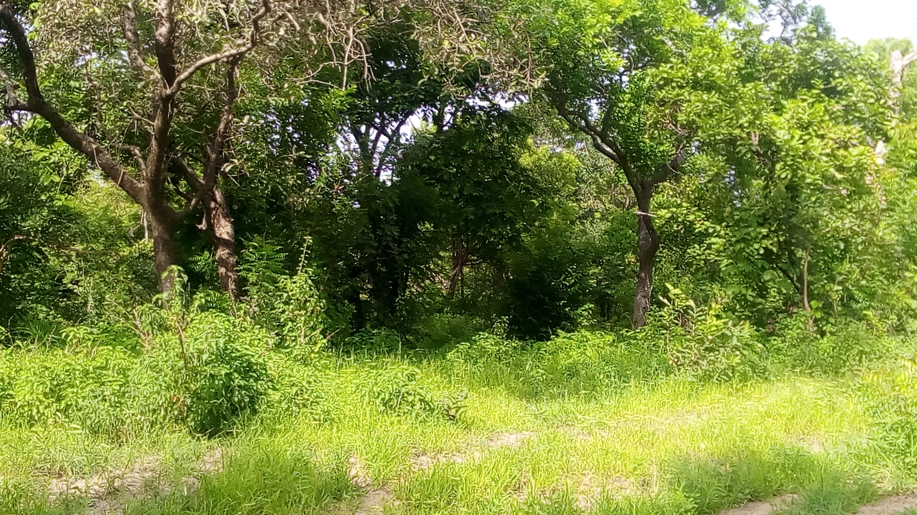
A dense green woodland savanna landscape with tall trees and thick undergrowth under sunlight.
A view of the woodland savanna landscape within the Forêt classée de la Sota.

Forêt classée de la Sota history and protected-area timeline

The Sota forest was officially designated a classified forest on 16 May 1947, marking it as one of the long-standing protected woodland reserves in what is now the Republic of Benin. This early designation placed the area under formal state protection during a period when colonial forest administrations were establishing a network of reserved woodlands across West Africa to secure timber resources, protect watersheds, and manage land use. The classification gave the forest a protected legal status that has carried through subsequent political transitions into the modern Beninese system of aires protégées.

During the second half of the twentieth century, the reserve became an important reference site for participatory forest management planning in Benin. A 1997 management plan, produced under the PAPFNRVRC project (Projet Aménagement Participatif de Forêts Naturelles et Reboisements Villageois pour Réduction de Carbone), covered the Sota forest alongside the Goungoun classified forest and the Goroubi rôneraie. Subsequent evaluations, including work documented in 2006, examined the criteria and indicators that determine the success of such participatory management approaches.

Silvicultural research on the reserve has been ongoing, with documented studies of experimental forestry plots tracking tree population dynamics in the classified forest. The reserve has also served as a site for field guides describing the wildlife of the broader Goungoun, Sota, and surrounding landscape. Together these efforts trace the long transition of the forest from an early colonial-era classified woodland into a contemporary reserve embedded in regional conservation planning, participatory management frameworks, and applied ecological research.

Forêt classée de la Sota landscape and geographic character

The physical setting of Forêt classée de la Sota is shaped by the Sudano-Sahelian climate, with a pronounced dry season that strongly influences both vegetation and human activity. The terrain consists largely of gently undulating plains characteristic of northern Benin, where seasonal watercourses and a few perennial rivers shape the topography more than dramatic relief features.

The central hydrological feature of the reserve is the Sota River itself, which crosses the protected area as a tributary of the Niger River, joining the larger river on its right (eastern) bank. The river corridor introduces alluvial soils, riparian vegetation, and seasonal flooding patterns that contrast with the drier upland plains. Soils across the reserve vary, with ferruginous tropical soils typical of the broader Sudano-Sahelian zone influencing agriculture and tree regeneration in many areas.

The vegetation mosaic of the reserve combines open dry forest with widely spaced trees and wooded savanna where grasses and isolated canopy trees dominate. This pattern produces a landscape of semi-open woodland interspersed with grassy patches, giving the reserve both visibility across its broad stretches and shaded gallery environments along the river system.
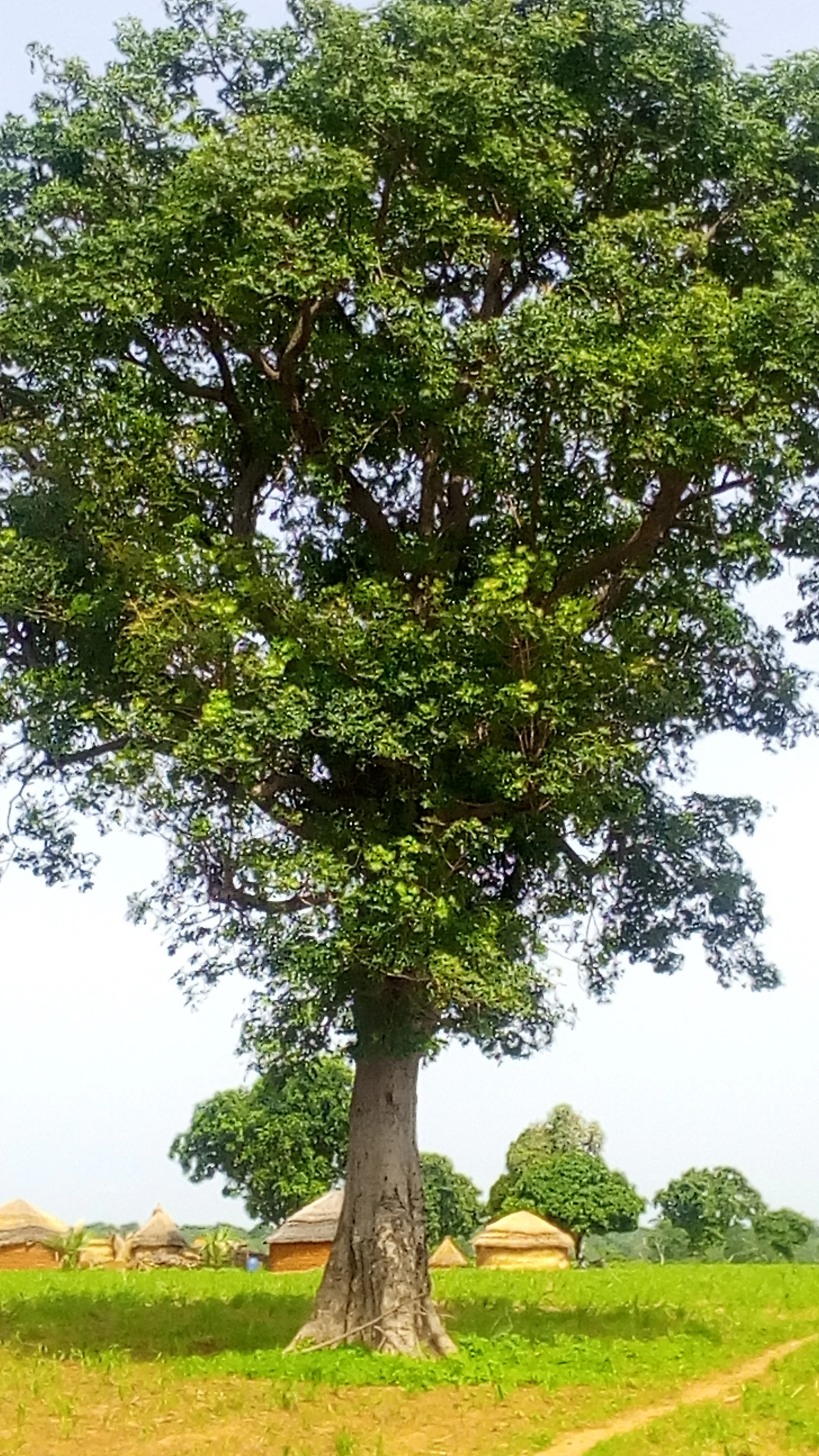
A large, mature tree with a thick trunk and a dense, wide canopy stands in a grassy savanna field with several small, thatched-roof huts in the distance.
A large tree stands in the woodland savanna of Forêt classée de la Sota, with traditional structures visible in the background.

Forêt classée de la Sota ecosystems, habitats, and plant life

Ecologically, the Sota classified forest represents a classic example of Sudano-Sahelian dry woodland and savanna. The vegetation pattern, marked by trees spaced widely apart over a grassy understory, reflects both the rainfall regime and the long history of human use, including grazing and the cutting of wood for fuel and construction.

Woody vegetation in the reserve includes both open-forest formations and more wooded-savanna areas, with trees adapted to seasonal drought and fire. The presence of distinct soil types across the reserve influences local vegetation composition, with some zones supporting denser tree growth while others remain dominated by grass cover. Forest management research has specifically examined the dynamics of tree populations in sylvicultural trial plots within the reserve, offering insights into how the woodland regenerates under contemporary conditions.

Riparian zones along the Sota River add a different ecological dimension to the reserve, supporting moisture-loving vegetation and aquatic fauna that depend on the river corridor. While much of the broader landscape is shaped by seasonal dryness, the river provides a persistent ecological thread that ties the reserve to the wider Niger River basin.
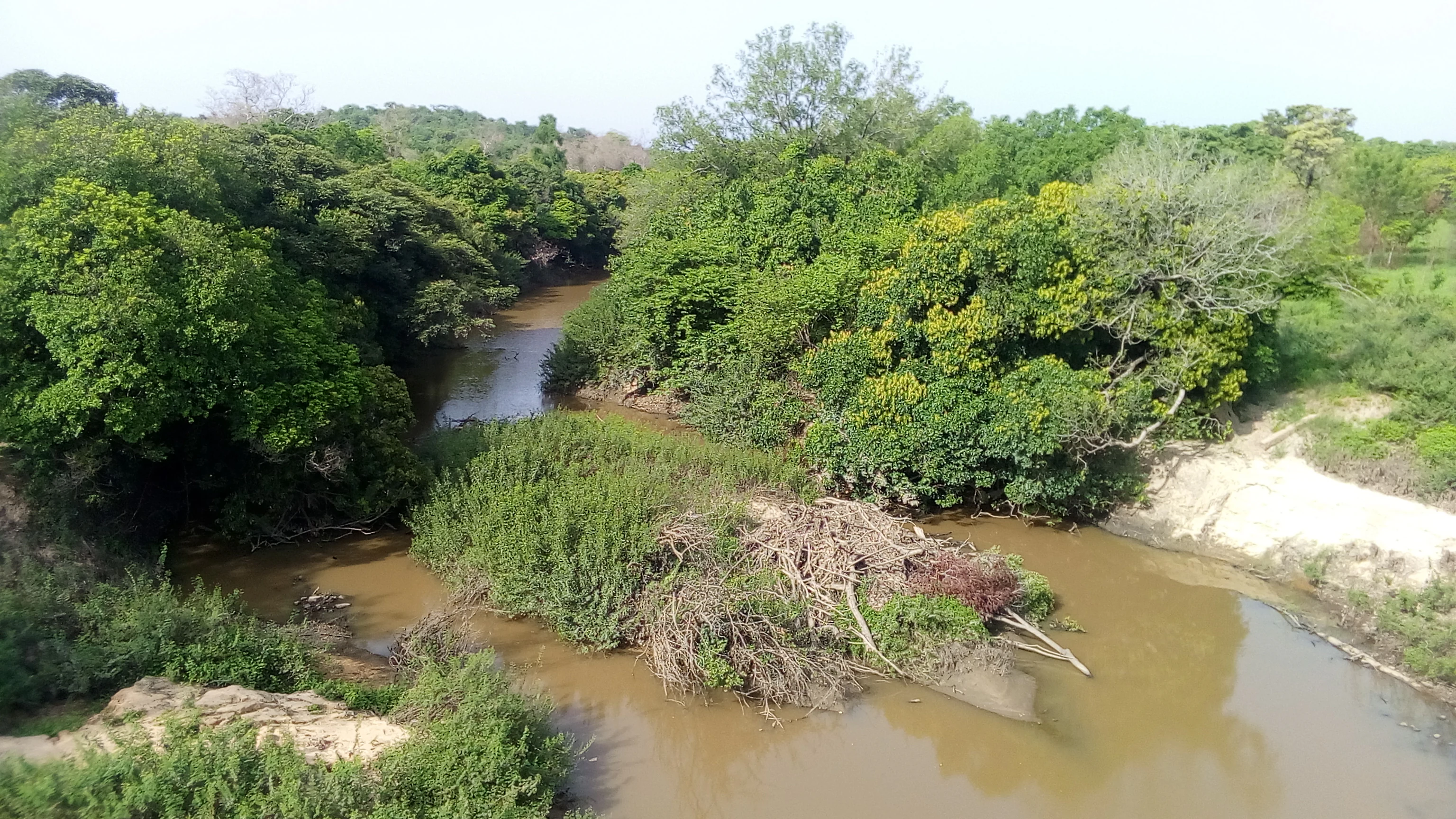
A brownish, slow-moving river winds through a lush, green woodland savanna landscape with dense trees lining the banks.
The Sota River flowing through the Forêt classée de la Sota in Benin.

Forêt classée de la Sota wildlife and species highlights

Wildlife in the Sota classified forest reflects both the historical richness of the West African dry woodland and the pressures of habitat change. Historical records note that elephants were still present in the forest as recently as 1952, illustrating a more diverse large-mammal fauna of the past. Like other reserves in the region, notably the Goungoun forest, the Sota reserve has seen declines in large mammal populations, though significant savanna species continue to survive within its boundaries.

Mammals currently documented in or around the reserve include hippotragues, often associated with the roan antelope; lycaons, the African wild dog; spotted hyenas; leopards; and civets. Some of these species are subject to hunting pressure, with the meat of certain animals reportedly appearing in surrounding markets, a dynamic that intersects with both local livelihoods and conservation concerns.

Aquatic fauna in the reserve is closely tied to the Sota River and includes tilapia and catfish (silures), fish species that occupy the river and its associated wetlands. Together, the terrestrial and aquatic fauna underscore the reserve's ecological identity as a dry-land woodland with an integral river system supporting both savanna mammals and freshwater species.
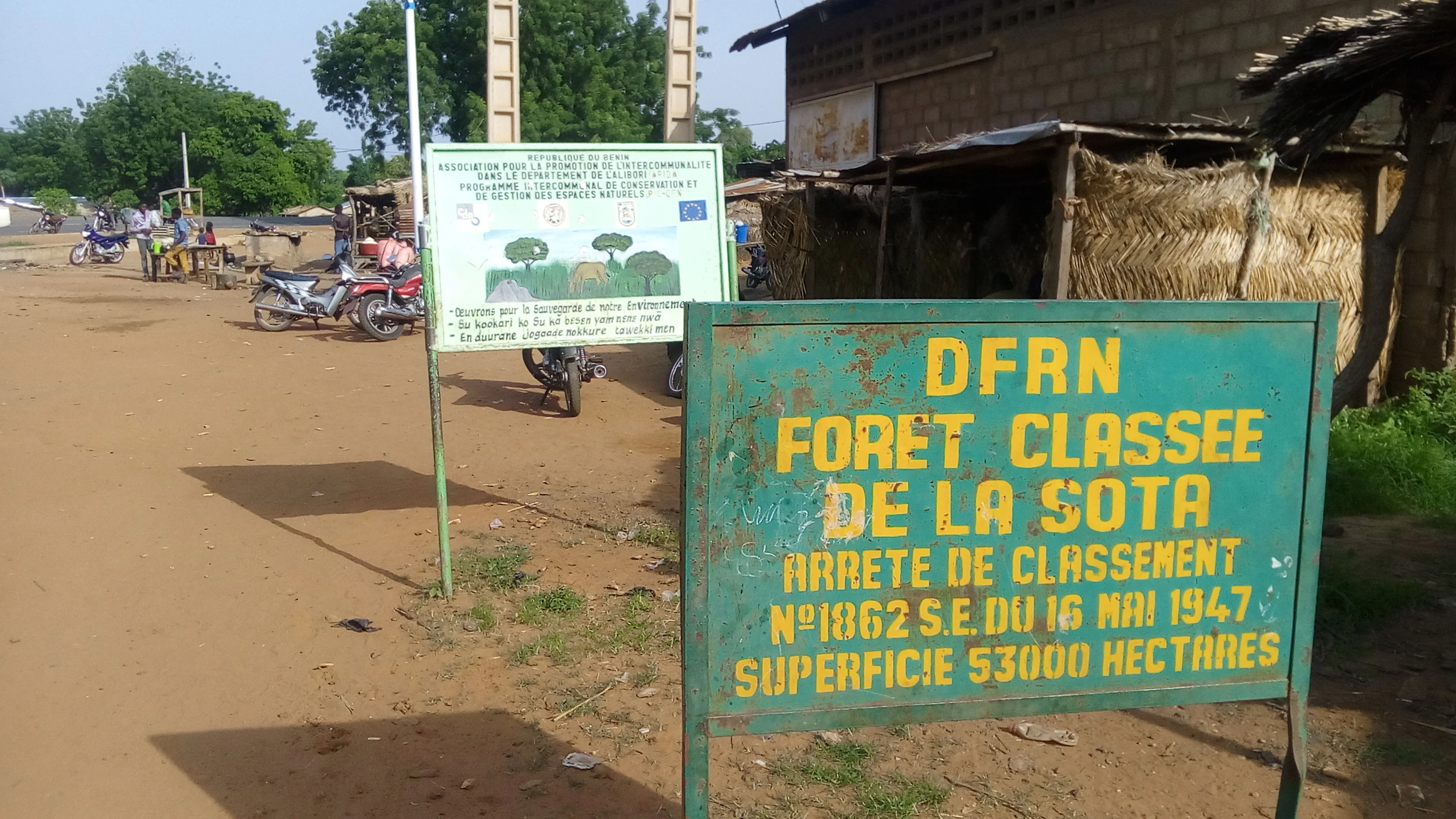
A green metal sign with yellow text reading DFRN FORET CLASSEE DE LA SOTA, along with information about its 1947 legal classification and 53,000 hectare surface area, set in an outdoor dirt area near another informational board.
Official entrance signage for the Forêt classée de la Sota in Benin.

Forêt classée de la Sota conservation status and protection priorities

The Sota classified forest has been under formal protection since 16 May 1947, making it one of the older woodland reserves in Benin's protected-area system. Its long protected status reflects the early recognition of these dry forests and savannas as important reserves of woodland cover, biodiversity, and natural resources in a region where land conversion and fuelwood demand are persistent pressures.

Conservation significance lies in the reserve's role as a refuge for Sudano-Sahelian woodland and savanna species, including African wild dogs, leopards, spotted hyenas, and roan antelope. The forest also anchors a regional cluster of protected woodland sites, alongside Goungoun and the Goroubi rôneraie, that together help maintain ecological connectivity and preserve representative samples of dry-zone vegetation.

Management of the reserve has been informed by participatory forestry planning. A 1997 management plan produced under a carbon-focused participatory forest and reforestation project laid out a framework for managing the Sota, Goungoun, and Goroubi reserves jointly. Subsequent evaluations have examined how well such participatory frameworks succeed, while ongoing sylvicultural research continues to inform restoration and sustainable-use policy. Despite these efforts, pressures from bush-meat hunting, agricultural expansion, and grazing remain meaningful concerns for the long-term integrity of the reserve.

Top sights and standout views in Forêt classée de la Sota

The Sota classified forest spans roughly 53,000 hectares of Sudano-Sahelian woodland and wooded savanna in northeastern Benin, protected continuously since 1947. The reserve is defined by its association with the Sota River, a Niger tributary that crosses the landscape and shapes local soils and vegetation, and by the continued presence of savanna wildlife such as roan antelope, African wild dogs, leopards, and spotted hyenas.

As part of a broader cluster of protected woodlands including the Goungoun forest and the Goroubi rôneraie, the Sota reserve represents both a long-standing example of Benin's classified-forest system and a working landscape where conservation, agriculture, grazing, and participatory management intersect.
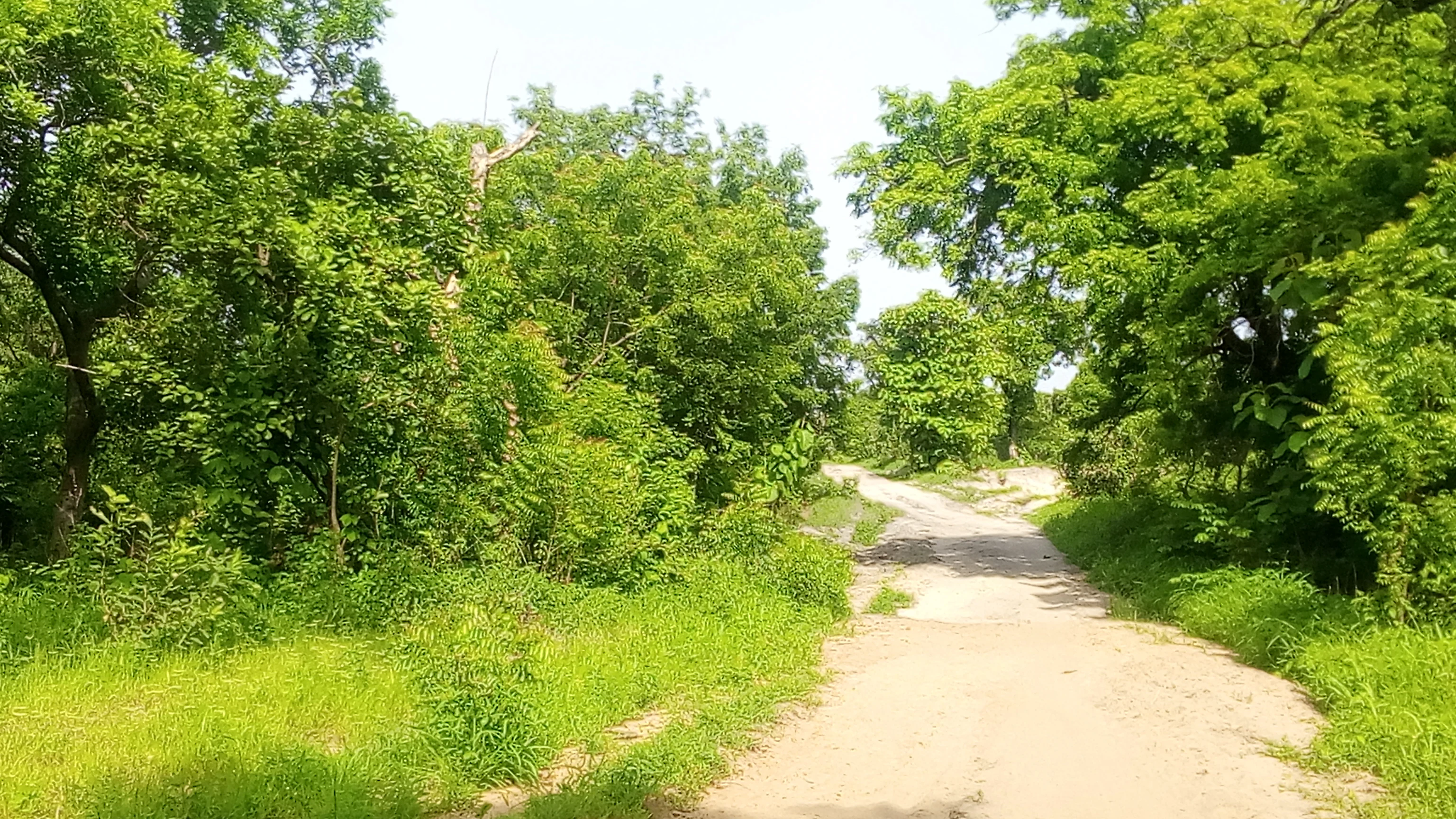
A sandy, unpaved trail leads into a dense forest with bright green trees and grassy undergrowth under a bright, overcast sky.
A dirt path winding through the lush woodland savanna of Forêt classée de la Sota.
Monthly climate preview

Representative annual temperature and precipitation rhythm from 1991 to 2020

Long-Term Climate Normals and Weather by Month for Forêt classée de la Sota

Long-term data records reveal distinct shifts in average monthly temperature and precipitation at the representative coordinate within Forêt classée de la Sota. Accessing the complete monthly profile provides deeper analytical depth on temperature ranges and rainfall patterns across the year.
Annual mean27 °C
24 °C32 °C
Jan24°
Feb27°
Mar31°
Apr32°
May30°
Jun28°
Jul26°
Aug25°
Sep26°
Oct27°
Nov26°
Dec24°
Warmest month
April

31.8 °C

Coolest month
December

24.1 °C

Wettest month
August

8.6 mm/day

Driest month
December

0 mm/day

Park location guide

Geography guide, regional context, and park location map for Forêt classée de la Sota

Forêt classée de la Sota park geography, regions, and map view in Benin

Understand where Forêt classée de la Sota sits in Benin through a broader geographic reading of the surrounding landscape, nearby location context, and its mapped position within the national park landscape.

How Forêt classée de la Sota fits into Benin

Benin is a West African nation formerly known as Dahomey. It gained independence from France in 1960 and operates as a unitary presidential republic. The country is known for its coastal location along the Bight of Benin, its historical kingdom of Dahomey, and its agricultural economy centered on palm oil and cotton exports.

Wider geography shaping Forêt classée de la Sota in Benin

Benin is located in West Africa, bordered by Togo to the west, Nigeria to the east, Burkina Faso to the northwest, and Niger to the northeast. The country occupies the southern coastline of the Bight of Benin, which is part of the Gulf of Guinea in the northernmost tropical portion of the Atlantic Ocean. The terrain ranges from coastal plains to hilly uplands in the north.

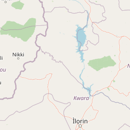
Map view of Forêt classée de la Sota

Use this park location map to pinpoint Forêt classée de la Sota in Benin, understand its exact geographic position, and read its mapped placement within the surrounding landscape more clearly.

Pigeon | © OpenStreetMap contributors

Location context for Forêt classée de la Sota

Alibori

Examine the dry savanna habitats, riverine corridors, and woodland scenery of northern Benin

Forêt classée de la Sota Photos and Landscapes: Visual Exploration of the Protected Reserve

Visual documentation reveals the distinct Sudano-Sahelian woodland mosaic, seasonal river corridors, and open savanna terrain defining the protected reserve. Examining these landscape photographs provides a clearer understanding of the ecological character and physical geography shaping the protected woodland.

A dense green woodland savanna landscape with tall trees and thick undergrowth under sunlight.

A view from a vehicle driving on a paved highway that cuts through a dense green forest and savanna landscape in Benin.

A large, mature tree with a thick trunk and a dense, wide canopy stands in a grassy savanna field with several small, thatched-roof huts in the distance.

A brownish, slow-moving river winds through a lush, green woodland savanna landscape with dense trees lining the banks.

A green metal sign with yellow text reading DFRN FORET CLASSEE DE LA SOTA, along with information about its 1947 legal classification and 53,000 hectare surface area, set in an outdoor dirt area near another informational board.

A close-up view of exposed soil and sediment layers along a steep, eroded bank. The soil features contrasting textures of white, sandy material and reddish clay, with a small termite mound visible on the slope.

A sandy, unpaved trail leads into a dense forest with bright green trees and grassy undergrowth under a bright, overcast sky.

Park atlas

Compare regional woodland reserves and connected conservation areas across northern Benin

Explore Parks Near Forêt classée de la Sota and Surrounding Protected Landscapes

Browsing other protected areas near Forêt classée de la Sota reveals broader patterns in Sudano-Sahelian woodland ecosystems and river basin geography. Expanding the regional comparison helps trace connected wildlife habitats and state-designated forest reserves across the surrounding landscape.
Nature reserveBenin
About 52 km away#1 closest

South

Forêt classée des Trois Rivières: Geographic Context and Protected Landscape Map

Nature reserve protecting vital northern Benin river catchments.

Spanning over 2,595 square kilometers in northern Benin, Forêt classée des Trois Rivières functions as a critical watershed protector for the Sota, Tassiné, and Bouli rivers. The reserve sustains a fragile Sudano-Sahelian ecosystem where open tree savanna and gallery forests provide refuge for elephants and other wildlife. Its mapped boundaries offer a look at the historical and ecological struggle to maintain intact forest fragments within a landscape defined by agricultural expansion and river basin management.

Area
2,595 km²
Established
1949
IUCN
II
Protected areaDosso Region
About 81 km away#2 closest

North

Dallol Maouri Protected Area: Geographic Overview of Niger's Fossilized Wetland Valleys

Mapping seasonal pond systems and floodplain corridors in the Dosso Region

Dallol Maouri serves as a quintessential example of the ancient drainage systems found in the Iullemmeden Basin. As a Ramsar-listed protected area, it features a unique north to south orientation that fosters a rich transition between dryland Sahel and Sudanian savanna. The valley is defined by its seasonal mares, palm groves, and intricate network of koris tributaries that shape the geography of southwestern Niger.

Area
3,175.2 km²
Established
2004
Relief
Lowland
Climate
Subtropical
Wildlife reserveDosso Region
About 82 km away#3 closest

North

Feuchtgebiet am mittleren Niger II: Wetland Geography and Wildlife Reserve Boundaries

A seasonal floodplain corridor in the Dosso Region of Niger.

Feuchtgebiet am mittleren Niger II offers a clear view into the flood-pulse ecology of the middle Niger River. The reserve comprises a complex network of channels, ponds, and riverine woodlands that shift with the annual rains. This protected site in the Dosso Region acts as a crucial transboundary conservation area, showcasing the unique interaction between riparian forests, baobab groves, and seasonal aquatic terrain.

Area
385.55 km²
Established
2004
Relief
Lowland
Scope
Terrestrial
Protected areaDosso
About 105 km away#4 closest

North

Feuchtgebiet am mittleren Niger: Protected Wetland Geography and River Floodplain Atlas

Geographic overview of floodplain terrain in Dosso, Niger

Feuchtgebiet am mittleren Niger preserves a vital mosaic of riverine channels, temporary ponds, and floodplain flats. This protected area stands as a distinctive aquatic corridor within the Sahel, characterized by diverse water-based habitats and seasonal vegetation shifts that define the regional geography of Dosso.

Area
521.8 km²
Established
2001
Relief
Lowland
Scope
Terrestrial
National parkBenin
About 113 km away#5 closest

West

Parc national du W du Benin: Regional Geography and Protected Savanna Landscapes

Northern Benin flagship protected area and transboundary conservation hub.

Located in northern Benin, Parc national du W du Benin provides a unique window into the Sudano-Sahelian zone. The park features a mosaic of riverine gallery forests along the Mékrou and Alibori rivers, stretching across open Sudanian savannas to meet the rugged edges of the Atacora mountains. This protected area stands as a central pillar in the WAP complex, offering a clear map of interconnected wildlife habitats and significant ecological corridors in West Africa.

Area
5,632.8 km²
Established
1950
IUCN
II
Relief
Upland
A horizontal watercolor painting showing a winding river flowing through a lush green landscape with distant rolling hills.
Protected areaBenin
About 117 km away#6 closest

Northwest

Complexe W-Arly-Pendjari: Regional Geography and Transboundary Protected Landscapes

Sudano-Sahelian savanna and riverine conservation corridors.

As a massive transboundary conservation area, the Complexe W-Arly-Pendjari protects nearly 1.5 million hectares of savanna, woodland, and rocky terrain. The complex links national parks across three countries to maintain a continuous habitat for West African megafauna. Its distinctive landscape transitions from lush gallery forests along river systems to open, dry plains, representing an essential geographic gradient for regional biodiversity.

Area
14,948.3 km²
Established
1996
Water
Major water bodies
National parkNiger
About 123 km away#7 closest

North

W National Park: Niger National Park, UNESCO World Heritage Site & Ramsar Wetland

Transborder savanna ecosystem and dramatic Niger River landscape.

W National Park in Niger offers a unique atlas view of a vast protected landscape defined by the Niger River's iconic W-shaped bend. As a UNESCO World Heritage Site and Ramsar Wetland, it protects crucial savanna plains, extensive floodplains, and rocky outcrops. This transborder conservation area is a vital habitat for West African wildlife, providing a rich context for geographic discovery and landscape exploration.

Area
10,000 km²
Established
1954
IUCN
II
Relief
Mixed relief
National parkBenin
About 149 km away#8 closest

West

Pendjari National Park: Mapping Benin's Primary Protected Savanna Ecosystem and Wilderness

Located in northwestern Benin, bordering the WAP transboundary complex.

Pendjari National Park represents a significant conservation landscape in West Africa, featuring a complex geography of river-fed riparian forests, sprawling savanna plains, and the high-elevation cliffs of the Atakora mountain range. This protected area offers a look into an intact savanna wilderness, serving as a vital sanctuary for large mammals and diverse bird species within its clearly defined boundaries.

Area
2,755 km²
IUCN
II
Relief
Highland
Climate
Subtropical

Common questions about visiting, size, designation, and location context for Forêt classée de la Sota

Forêt classée de la Sota FAQs for park facts, access, geography, and protected area context

Find quick answers about Forêt classée de la Sota, including protected-area facts, park geography, trail and visitor context, and how the park fits into its surrounding country and regional landscape.
MoriAtlas Explorer

Continue Your Protected Areas Search Across the Global Atlas

Deepen your exploration by continuing the structured search for national parks and protected areas worldwide. Utilize the comprehensive filtering capabilities to compare different conservation landscapes and refine your understanding of global park geography. Discover more about the distribution and characteristics of protected natural areas.

Global natural geography