Mori Atlas logo
Protected areaForêt classée de Nialama

Mapping the mosaic of gallery forests, cliffs, and savanna in the Fouta Djalon plateau.

Forêt classée de Nialama: A Protected Highland Forest and Biodiversity Landscape in Guinea

Forêt classée de Nialama serves as a vital protected area within the Fouta Djalon highlands of north-western Guinea. This classified forest encompasses a diverse topography where escarpments, seasonal swamps, and undulating plains sustain a mosaic of gallery woodland and wooded savanna. The site acts as a key conservation node for resident chimpanzee populations and avian species, representing an essential segment of West African highland geography.

classified forestFouta Djalonhighland forestgallery forestwooded savannabamboo stands

Forêt classée de Nialama

Protected area

Park overview

Structured park overview, official facts, and landscape profile for Forêt classée de Nialama

Forêt classée de Nialama park facts, protected area profile, and essential visitor context

Review the core facts for Forêt classée de Nialama, including designation, size, terrain, visitor scale, habitats, and operating context in one park-focused overview.

About Forêt classée de Nialama

Forêt classée de Nialama is one of the structured protected forest units of north-western Guinea, set within the highland terrain of the Fouta Djalon. Its position places it in a transitional zone where sudden escarpments, rolling hills, and open plains meet, producing a varied landscape of cliffs, low plains, and seasonal swampy lowlands.

The forest covers about 10,000 hectares and rises between approximately 200 and 900 meters in elevation. Annual rainfall averages around 1,145 mm, characteristic of the Sudano-Guinean climate that shapes both vegetation and seasonal water flows across the plateau. The combination of altitude, varied relief, and seasonal wetlands produces a mosaic of habitats rather than a uniform block of closed forest.

Ecologically, Nialama is most important as a refuge for western chimpanzees in the Fouta Djalon and as an Important Bird Area of regional significance. Its mix of gallery forests, open woodlands, wooded savannas, bamboo stands, and grasslands gives it transitional character: neither purely Guinean forest nor pure Sudanian savanna, but a blend of both. The presence of chimpanzee groups that appear to be year-round residents highlights its role as a stable habitat patch rather than a transit zone.

Quick facts and research context for Forêt classée de Nialama

Forêt classée de Nialama is a classified forest in the north-western Guinea highlands, falling within the elevated Fouta Djalon region. It lies around the locality of Linsansaran, at elevations ranging roughly from 200 to 900 meters above sea level, and covers approximately 10,000 hectares.

The protected area combines hills, cliffs, escarpments, low gently undulating plains, and seasonal swamps. It hosts a mosaic of gallery forests, open forests, wooded savanna, and bamboo stands, and has annual rainfall of roughly 1,145 mm. The site is notable as habitat for western chimpanzees and as an Important Bird Area recognized by BirdLife International.

Protection and recognition

Examine the official protection status, management framework, and records for Forêt classée de Nialama.

Forêt classée de Nialama Protection Status and Designated Area Record

Examine the official protection status and administrative records linked to Forêt classée de Nialama. Official database entries provide structured context regarding the protected area designation and registry tracking.

Protection details

WDPA ID
317286
Park context

Deeper park guide and search-rich context for Forêt classée de Nialama

Forêt classée de Nialama history, landscape, wildlife, and travel context

Explore Forêt classée de Nialama through its history, landscape character, ecosystems, wildlife, conservation priorities, cultural context, and seasonal travel timing in a structured park guide built for atlas discovery and search intent.

Why Forêt classée de Nialama stands out

Nialama is known above all for its population of western chimpanzees (Pan troglodytes verus) and its exceptional bird diversity within the Fouta Djalon landscape. Surveys in the late 1990s identified four social groups of chimpanzees in the forest, three of which appeared to be permanent residents, with an estimated total of around 83 individuals. Equally important is the forest's status as an Important Bird and Biodiversity Area. It supports meaningful populations of violet turacos, red-throated bee-eaters, blue-bellied rollers, bearded barbets, fox kestrels, Senegal parrots, piapiacs, white-crowned cliff chats, chestnut-crowned sparrows, and Sahel bush sparrows. Together, primates and birds give this classified forest its strong conservation identity.

Forêt classée de Nialama landscape and geographic character

The landscape of Forêt classée de Nialama is shaped by the Fouta Djalon plateau, with elevations that range from roughly 200 to 900 meters above sea level. The terrain is strongly varied, moving from hills and cliffs to lower, gently undulating plains. Sharp escarpments and exposed rock faces contrast with smoother lowland stretches, while seasonal swamps collect in the lower ground during the rainy period.

This relief creates natural breaks between vegetation types. Forest patches cling to valleys and watercourse corridors, while more open formations occupy the slopes and plateaus above. The overall impression is of a broken highland landscape: not a continuous forest block, but a tapestry where cliff lines, valley floors, grassy plains, and seasonally flooded areas alternate over short distances.

Forêt classée de Nialama ecosystems, habitats, and plant life

Vegetation at Nialama reflects its position at the meeting point between Sudano-Guinean highland forests and drier savanna landscapes. The classified forest contains a mosaic of dense gallery forests, more open forests, wooded savanna, grasslands, and patches of bamboo formed by Oxytenanthera abyssinica.

Key woody species include Parkia biglobosa and Pterocarpus erinaceus as the dominant forest trees, with Afzelia africana and the oil palm (Elaeis guineensis) present in the savanna zones. The bamboo stands add another distinct habitat layer, while gallery forests along watercourses create corridors of dense, evergreen vegetation. Together, these vegetation types support a wide range of West African plant communities within a relatively compact protected area.

Forêt classée de Nialama wildlife and species highlights

Wildlife at Nialama is characterized by the strong presence of western chimpanzees (Pan troglodytes verus) and by a rich community of West African birds. A late-1990s survey conducted under Guinea's chimpanzee conservation project identified four social groups of chimpanzees in the area, three of which were believed to occupy their ranges permanently. The total population across these groups was estimated at about 83 individuals.

Birdlife is exceptional: the site is recognized as an Important Bird and Biodiversity Area because it supports important populations of violet turacos, red-throated bee-eaters, blue-bellied rollers, bearded barbets, fox kestrels, Senegal parrots, piapiacs, white-crowned cliff chats, chestnut-crowned sparrows, and Sahel bush sparrows. This combination of primates and many savanna and woodland bird species reflects the mosaic nature of the forest.

Forêt classée de Nialama conservation status and protection priorities

The principal conservation value of Nialama lies in its role as a habitat refuge for the western chimpanzee, a recognized priority subspecies across West Africa, and as an Important Bird and Biodiversity Area designated by BirdLife International. The protection of roughly 10,000 hectares of highland forest, gallery woodland, savanna, and seasonal swamp secures a representative sample of Fouta Djalon ecosystems in a single site.

Its importance is reinforced by the apparent year-round presence of multiple chimpanzee groups within distinct home ranges, indicating that the forest retains the stability needed for resident primate populations. Combined with its birdlife significance, Nialama contributes meaningfully to regional conservation networks in north-western Guinea, complementing broader efforts in the Fouta Djalon to maintain connectivity for forest and savanna species under Sudano-Guinean climate conditions.

Top sights and standout views in Forêt classée de Nialama

Forêt classée de Nialama combines several distinctive features within a single classified forest: highland Fouta Djalon terrain with cliffs, escarpments, and seasonal swamps; a mosaic of gallery forests, open forests, savanna, and bamboo stands; resident western chimpanzee groups; and recognition as an Important Bird Area by BirdLife International.

Best time to visit Forêt classée de Nialama

The climate at Nialama is shaped by the Sudano-Guinean rainfall regime of the Fouta Djalon, with annual precipitation averaging around 1,145 mm. Seasonal swamps are most extensive during and shortly after the rainy period, when valley bottoms and low plains fill with water; in drier months, open savanna, grassland, and bamboo zones become more accessible and the seasonal swamps recede.

Wildlife viewing tends to favor different conditions at different times of year. The wetter months bring out more active vegetation and can concentrate animals near water and in gallery forests, while drier periods make open landscapes easier to observe and highlight the savanna and bamboo components of the mosaic. Visitors prioritizing birdwatching should expect the strongest activity during periods when resident species such as turacos, bee-eaters, rollers, and parrots are most visible around fruiting trees and water sources.

Monthly climate preview

Annual temperature ranges and precipitation rhythm from representative coordinate data

Forêt classée de Nialama Climate Normals and Measured Temperature Patterns

Long-term data records reveal measured temperature fluctuations and monthly precipitation shifts across the representative coordinate. Examining the complete twelve-month normals provides deeper analytical context for understanding annual environmental variations across the protected landscape.
Annual mean24 °C
22 °C28 °C
Jan24°
Feb26°
Mar28°
Apr28°
May27°
Jun24°
Jul23°
Aug22°
Sep22°
Oct23°
Nov22°
Dec22°
Warmest month
April

28.4 °C

Coolest month
August

22 °C

Wettest month
August

16.7 mm/day

Driest month
December

0 mm/day

Park location guide

Geography guide, regional context, and park location map for Forêt classée de Nialama

Forêt classée de Nialama park geography, regions, and map view in Guinea

Understand where Forêt classée de Nialama sits in Guinea through a broader geographic reading of the surrounding landscape, nearby location context, and its mapped position within the national park landscape.

How Forêt classée de Nialama fits into Guinea

Guinea is a West African country with a population of approximately 14 million people. The country achieved independence from France in 1958 and is known for its diverse geography ranging from coastal lowlands to highland plateaus. Conakry serves as both the capital and largest city. Guinea is a member of the United Nations, ECOWAS, the African Union, and La Francophonie.

Wider geography shaping Forêt classée de Nialama in Guinea

Guinea is located on the West African Atlantic coast, bordered by Guinea-Bissau to the northwest, Senegal to the north, Mali to the northeast, Ivory Coast to the southeast, and Sierra Leone and Liberia to the south. The country is divided into four geographic regions: Maritime Guinea along the Atlantic coast, the Fouta Djallon highlands in Middle Guinea, the Upper Guinea savanna in the northeast, and the forested Guinea region in the southeast.

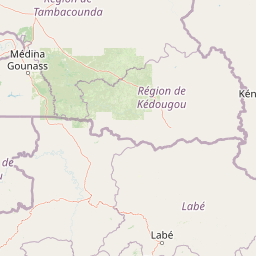
Map view of Forêt classée de Nialama

Use this park location map to pinpoint Forêt classée de Nialama in Guinea, understand its exact geographic position, and read its mapped placement within the surrounding landscape more clearly.

Pigeon | © OpenStreetMap contributors
Park atlas

Compare adjacent highland reserves and connected West African conservation landscapes

Parks Near Forêt classée de Nialama and Surrounding Regional Protected Areas

Browse other protected areas near Forêt classée de Nialama to evaluate adjacent highland terrain and regional gallery forest mosaics. Expanding the geographical comparison reveals wider patterns across the surrounding Fouta Djalon conservation corridor.
Protected areaGuinea
About 98 km away#1 closest

Southwest

Rio Pongo: A Protected Estuarine Wetland Landscape in Coastal Guinea

Mapping mangrove forests, tidal mudflats, and coastal ecology

Rio Pongo is a prominent protected area in Guinea, characterized by a complex network of brackish tidal channels and dense mangrove forests. The site serves as a crucial habitat for waterbirds and aquatic mammals, while its position at the edge of the Atlantic Ocean defines a dynamic, low-lying coastal terrain that remains vital for regional conservation and ecological research.

Area
300 km²
Established
1992
Water
Water-dominated
National parkSenegal
About 124 km away#2 closest

North

Niokolo-Koba National Park: Exploring Senegal's Protected Landscape Identity

Mapped boundaries and regional geography context.

Niokolo-Koba National Park offers a distinct focus on Senegal's protected landscapes, providing valuable insights for atlas and map-based exploration. This national park serves as a key geographic anchor, highlighting the natural terrain and the extent of its protected boundaries within the country. Users can delve into the specific characteristics of this area to understand its role within Senegal's diverse natural heritage and regional geography.

Area
9,130 km²
Established
1954
IUCN
II
Relief
Upland
National parkGuinea
About 129 km away#3 closest

Northwest

Badiar National Park: A Transboundary Protected Landscape in Northeastern Guinea

Exploring savanna ecosystems and riverine corridors

Badiar National Park encompasses over 1,200 square kilometers of diverse West African terrain in northeastern Guinea. This protected area features a unique mosaic of open woodlands, savanna, and lush gallery forests along the Koulountou River. Serving as a transboundary ecological link, the park provides an essential habitat corridor that is critical for regional biodiversity and landscape-scale conservation planning within the West African savanna belt.

Area
1,228 km²
Established
1985
IUCN
II
Climate
Tropical
National parkBoké
About 129 km away#4 closest

Northwest

Parc national du Badiar: Protected Savanna and Transboundary Geography in Boké, Guinea

Explore the mapped landscape of a major West African biodiversity stronghold

Parc national du Badiar serves as a central node in West African conservation, characterized by its open savanna plains and lush riverine forest corridors. As an established protected area, the region provides essential habitat connectivity and maintains a complex mosaic of vegetation types that define the regional geography of northern Guinea.

Area
382 km²
Established
1985
IUCN
II
Relief
Lowland
A wide watercolor illustration showing green hills and trees along a pale river valley with a soft sky.
Protected areaMamou Region
About 154 km away#5 closest

Southeast

Bafing-Source Protected Area: A Highland Wetland Landscape in the Mamou Region

Tracing the headwaters and plateau geography of the Bafing River basin

The Bafing-Source protected area serves as a significant hydrological anchor within the Fouta Djallon highlands of Guinea. This expansive site protects critical wetland catchments and plateau terrain that feed into the broader Senegal River system, demonstrating the vital link between highland ecosystems and downstream water security.

Area
3,172 km²
Established
2007
Relief
Highland
Climate
Tropical
Watercolor painting of a soft, layered landscape featuring green trees and gentle hills against a pale, warm sky.
Nature reserveIvory Coast
About 199 km away#6 closest

Southeast

Forêt classée de Pinselly: Protected Area Geography and Landscape Mapping

Nature reserve analysis and regional atlas context

Examine the formal boundaries and landscape character of Forêt classée de Pinselly. This atlas entry focuses on the geographic structure and environmental positioning of this nature reserve in Ivory Coast, offering a clear view of its role as a protected landscape.

Established
1945
Relief
Mountain
Climate
Tropical
Access
Moderate access
National parkKarene District
About 216 km away#7 closest

South

Outamba-Kilimi National Park: Sierra Leone National Park and Protected Landscape Atlas

Mapped natural terrain within Karene District.

Investigate Outamba-Kilimi National Park as a protected area, examining its geographic footprint and significance within Sierra Leone's natural landscapes. This detailed entry provides context on the park's mapped boundaries and its contribution to regional geography, serving as a key point for atlas-based exploration of conservation lands in the Karene District.

Area
1,109 km²
Established
1986
IUCN
II
Relief
Lowland
Nature reserveBoke Region
About 232 km away#8 closest

Southwest

Rio Kapatchez Managed Nature Reserve: Coastal Estuarine Mapping and Protected Area Overview

Tidal wetland geography within the Boke region of Guinea

Examine the protected coastal landscapes of Rio Kapatchez Managed Nature Reserve, a significant wetland system where freshwater river flow merges with Atlantic tidal influences. This reserve provides an essential geographic look at mangrove-rich estuarine environments and the sediment-driven topography of the western Guinean coastline.

Area
200 km²
Established
1992
Relief
Lowland
Scope
Mixed

Common questions about visiting, size, designation, and location context for Forêt classée de Nialama

Forêt classée de Nialama FAQs for park facts, access, geography, and protected area context

Find quick answers about Forêt classée de Nialama, including protected-area facts, park geography, trail and visitor context, and how the park fits into its surrounding country and regional landscape.
MoriAtlas Explorer

Continue Your Protected Areas Search Across the Global Atlas

Deepen your exploration by continuing the structured search for national parks and protected areas worldwide. Utilize the comprehensive filtering capabilities to compare different conservation landscapes and refine your understanding of global park geography. Discover more about the distribution and characteristics of protected natural areas.

Global natural geography