Mori Atlas logo
National parkOutamba-Kilimi National Park

Explore the mapped boundaries and natural terrain of this significant national park.

Outamba-Kilimi National Park: Sierra Leone's Protected Landscape and Regional Geography

Outamba-Kilimi National Park stands as a protected natural area within Sierra Leone's Karene District. As a national park, its designation signifies a commitment to preserving a specific geographic region and its associated landscapes. This page offers an atlas-driven view, focusing on the park's mapped boundaries and its role within the broader regional geography, providing essential context for understanding protected lands.

national parkchimpanzee sanctuaryWest AfricaGuinea borderforest elephant habitatImportant Bird Area

Outamba-Kilimi National Park

National park

Park overview

Structured park overview, official facts, and landscape profile for Outamba-Kilimi National Park

Outamba-Kilimi National Park park facts, protected area profile, and essential visitor context

Review the core facts for Outamba-Kilimi National Park, including designation, size, terrain, visitor scale, habitats, and operating context in one park-focused overview.

About Outamba-Kilimi National Park

Outamba-Kilimi National Park represents Sierra Leone's commitment to preserving its natural heritage in the face of increasing development pressures across West Africa. The park's location in the mountainous northwestern region places it at a critical ecological crossroads between the Upper Guinean forests of Liberia and Côte d'Ivoire and the more open landscapes of Guinea's highlands. This positioning has allowed the park to maintain a remarkable diversity of habitats within a relatively compact boundary. The two named sections, Outamba and Kilimi, each offer distinct ecological characters despite their proximity, with Outamba featuring more extensive closed-canopy forest patches amid tall-grass savanna while Kilimi presents a more open savanna woodland character. Both areas share important riparian habitats along the major rivers that bisect the park, with gallery forests and swamp forests providing critical refuge for wildlife during dry seasons. The park's establishment history reflects a gradual recognition of its ecological importance, transitioning from a game reserve in 1974 to full national park status in 1995, a period during which conservation science increasingly understood the global significance of West African forest ecosystems.

Quick facts and research context for Outamba-Kilimi National Park

Located in Karene District in northwestern Sierra Leone, Outamba-Kilimi National Park occupies a strategic position near the Guinea border. The park consists of two connected zones named after prominent geographical features: Mount Outamba and River Kilimi. Its elevation ranges from flat lowland areas to hilly terrain, with several large rivers flowing southwest through the protected area. The park was formally designated as a national park in 1995 after serving as a game reserve since 1974. It has been recognized as an Important Bird Area by BirdLife International due to its significant bird populations. The surrounding buffer zone extends one kilometer from the park boundary and supports local communities, primarily from the Susu ethnic group.

Protection and recognition

Exploring the terrestrial conservation scope and official 1995 designation history

Outamba-Kilimi National Park Protection Status and Designation History

Detailed records trace the terrestrial protection status of Outamba-Kilimi National Park, established officially in 1995 to preserve regional conservation landscapes. Reviewing documented designation details provides essential geographic context for analyzing the legal framework and historical management of the protected habitat.

Protection details

Protection scope
Terrestrial
Designated year
1995
Park context

Deeper park guide and search-rich context for Outamba-Kilimi National Park

Outamba-Kilimi National Park history, landscape, wildlife, and travel context

Explore Outamba-Kilimi National Park through its history, landscape character, ecosystems, wildlife, conservation priorities, cultural context, and seasonal travel timing in a structured park guide built for atlas discovery and search intent.

Why Outamba-Kilimi National Park stands out

Outamba-Kilimi National Park is primarily renowned for its substantial population of western chimpanzees, which were the original justification for establishing the protected area in the 1970s. The park's significance extends beyond primates to include remarkable megafauna such as forest elephants, both common hippopotamuses and the more elusive pygmy hippo, and rare bongo antelopes. Its designation as an Important Bird Area reflects exceptional avian diversity with over one hundred recorded species. The park also stands out for its mosaic of habitats combining gallery forests along rivers, closed-canopy woodland, tall-grass savanna, and unique raffia palm swamp forests, creating one of West Africa's most ecologically varied protected landscapes.

Outamba-Kilimi National Park history and protected-area timeline

The area that now comprises Outamba-Kilimi National Park was first protected in 1974 when it was designated as a game reserve, reflecting early recognition by Sierra Leone's government of the region's ecological significance. The formal elevation to national park status came in October 1995, completing a two-decade evolution from initial protection to full conservation designation. The original impetus for protecting the area stemmed from scientific surveys that revealed exceptionally high populations of western chimpanzees, a species increasingly recognized as globally threatened. This chimpanzee focus distinguished Outamba-Kilimi from many other African parks that were established primarily for iconic megafauna like elephants or lions. The subsequent decades have seen ongoing efforts to balance conservation objectives with the needs of local communities, particularly the Susu people who have historically inhabited the region. Some villages were relocated to a buffer zone surrounding the park, though families with ancestral gravesites were permitted to remain under strict sustainable-use agreements.

Outamba-Kilimi National Park landscape and geographic character

The physical landscape of Outamba-Kilimi National Park presents a compelling combination of highland and lowland terrain that contributes to its ecological diversity. The park is anchored by Mount Outamba, the highest peak in the area, which provides elevation changes and associated habitat variation within the protected area. The terrain is predominantly flat with scattered hills, creating an accessible landscape that nonetheless offers visual variety and ecological stratification. Several major rivers flow through the park in a southwesterly direction, including the eponymous River Kilimi, which serves as a vital water source and corridor for wildlife movement. These river systems have carved valleys that support distinctive riparian environments different from the surrounding upland habitats. The combination of elevated terrain near the Guinea border, central flat plains, and river valleys creates a three-dimensional landscape that supports the mosaic of vegetation types found within the park.

Outamba-Kilimi National Park ecosystems, habitats, and plant life

The ecological character of Outamba-Kilimi is defined by a sophisticated mosaic of habitat types that reflects the park's transitional position between West Africa's forest and savanna zones. Gallery forests line the major rivers, providing dense, humid corridors of vegetation that support moisture-dependent species and serve as movement pathways for forest-dwelling wildlife. Adjacent to these riparian zones are patches of closed-canopy forest that represent fragments of the once-extensive Upper Guinean forest ecosystem. The broader landscape consists of woodland and tall-grass savanna, with the Outamba section characterized by more extensive savanna and woodland interspersed with forest patches, while Kilimi maintains a more open savanna woodland character throughout. Particularly distinctive are the raffia palm swamp forests found in both sections, which represent a specialized habitat type adapted to seasonal waterlogging and providing unique ecological functions. Riverine grasslands complete the habitat mosaic, offering yet another environmental niche within the park's boundaries.

Outamba-Kilimi National Park wildlife and species highlights

The wildlife community of Outamba-Kilimi National Park reflects the park's position in a biogeographically rich region of West Africa. Primates form a particularly significant component of the park's fauna, with western chimpanzees being the flagship species and original justification for protection, joined by colobus monkeys and sooty mangabeys that exploit the variety of forest and woodland habitats. Large mammals are well represented, with both common hippopotamuses and the more secretive pygmy hippo found in the park's river systems, while forest elephants move through the woodland and forest areas. Common warthogs are present in the more open savanna sections, and the park is notable for supporting populations of bongo antelopes, a species that is rarely encountered across its range. The bird community is exceptionally diverse, with over one hundred species recorded and the park recognized as an Important Bird Area by BirdLife International, signifying its global significance for bird conservation.

Outamba-Kilimi National Park conservation status and protection priorities

Outamba-Kilimi National Park holds significant conservation importance at multiple scales, from national priority to international recognition. The park's designation as an Important Bird Area by BirdLife International reflects global acknowledgment of its value for bird conservation, with the area supporting significant populations of species that depend on its diverse habitats. The western chimpanzee population, which was the catalyst for the park's establishment, continues to face pressures across its range in West Africa, making Outamba-Kilimi's protected population increasingly valuable for species survival. The park also contributes to regional conservation of forest elephants, a distinct species from their savanna counterparts and equally threatened by habitat loss and poaching. The management approach incorporates local communities through a buffer zone system that allows sustainable resource use while protecting core conservation areas, a model that recognizes that long-term conservation success depends on community buy-in and alternative livelihoods.

Outamba-Kilimi National Park cultural meaning and human context

The Susu people, also known as Soso, are the primary ethnic community living in and around Outamba-Kilimi National Park, and their relationship with the landscape predates formal conservation designation. Most park personnel originate from Susu communities, creating an important connection between traditional land management and modern protected-area management. When the park was established, some villages that had historically been located within the park boundary were relocated to the surrounding buffer zone, though families with ancestral sites, graves, and traditional claims were permitted to remain under strict conditions. Those remaining in the park have agreed to sustainable harvesting practices that avoid extractive activities like mining and hunting, maintaining a balance between traditional livelihoods and conservation objectives. The one-kilometer buffer zone surrounding the park accommodates the majority of local villages with more flexible rules that permit hunting of non-protected species and sustainable farming, while plantation forestry using gmelina trees provides alternative sources of firewood, timber, and income.

Top sights and standout views in Outamba-Kilimi National Park

Outamba-Kilimi National Park offers visitors an opportunity to experience one of West Africa's most ecologically diverse protected areas while supporting conservation of globally threatened species. The chimpanzee population remains the park's most celebrated feature, with guided treks providing chances to observe these intelligent primates in their natural habitat. River excursions along the Kilimi and other waterways offer hippo viewing opportunities, while the landscape's variety supports memorable wildlife encounters across multiple habitat types. The park's relatively low tourism infrastructure, with simple but authentic local-style huts, provides an immersive experience relatively untouched by commercial tourism development. The Karangia Trail, named for a Susu phrase meaning Hill of Learning, offers interpretive access to the park's landscapes and cultural context.

Best time to visit Outamba-Kilimi National Park

The optimal period for visiting Outamba-Kilimi National Park falls during the dry season, typically from November to April, when wildlife becomes more concentrated around remaining water sources and vegetation is less dense, improving sighting opportunities. The landscape at this time is characterized by golden grasses and clearer skies that provide excellent photography conditions. The wet season from May to October brings lush green vegetation but more challenging conditions for wildlife viewing as animals disperse and trails become difficult. Birdwatching remains productive throughout the year, though migratory species are more common during the dry season. Visitors should be prepared for the park's remote location and limited infrastructure regardless of when they travel, with the dry season offering more reliable access to remote areas.
Monthly climate preview

Long-term temperature averages and monthly precipitation patterns in Karene District

Outamba-Kilimi National Park Monthly Climate and Weather Normals

Long-term data at a representative elevation of 436 meters reveals a climate marked by substantial precipitation swings and high temperatures peaking before the wet season. Reviewing the complete twelve-month profile clarifies the exact transitions between arid periods and intense wet cycles across the Outamba-Kilimi National Park landscape.
Annual mean25 °C
23 °C29 °C
Jan25°
Feb27°
Mar29°
Apr29°
May27°
Jun25°
Jul24°
Aug23°
Sep24°
Oct24°
Nov24°
Dec23°
Warmest month
March

29.2 °C

Coolest month
August

23.2 °C

Wettest month
August

18.1 mm/day

Driest month
December

0.1 mm/day

Park location guide

Geography guide, regional context, and park location map for Outamba-Kilimi National Park

Outamba-Kilimi National Park park geography, regions, and map view in Sierra Leone

Understand where Outamba-Kilimi National Park sits in Sierra Leone through a broader geographic reading of the surrounding landscape, nearby location context, and its mapped position within the national park landscape.

How Outamba-Kilimi National Park fits into Sierra Leone

Sierra Leone is a West African country located on the Atlantic coast, bordered by Liberia to the southeast and Guinea to the north and east. The country has a tropical climate and diverse terrain ranging from coastal plains to mountainous interior regions. It was a British colony that gained independence in 1961 and became a republic in 1971. Following a devastating civil war that ended in 2002, Sierra Leone has experienced political stability and economic recovery.

Wider geography shaping Outamba-Kilimi National Park in Sierra Leone

Sierra Leone is situated on the West African Atlantic coast, occupying a rectangular territory stretching from the Atlantic ocean inland. The country borders Liberia to the southeast and Guinea to the north and east. Terrain includes a coastal plain, the Sierra Leone Peninsula, the mountainous interior around the Loma Mountains, and an eastern plateau region.

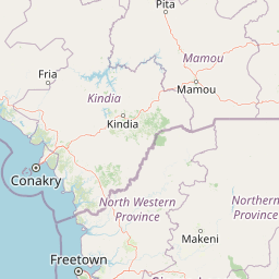
Map view of Outamba-Kilimi National Park

Use this park location map to pinpoint Outamba-Kilimi National Park in Sierra Leone, understand its exact geographic position, and read its mapped placement within the surrounding landscape more clearly.

Pigeon | © OpenStreetMap contributors

Location context for Outamba-Kilimi National Park

Karene District
Park atlas

Explore West African Protected Landscapes and Regional Park Geography for Comparison

Discover Nearby National Parks and Protected Areas Beyond Outamba-Kilimi National Park

Browse a curated list of national parks and other protected areas geographically situated near Outamba-Kilimi National Park, extending your exploration of West African conservation landscapes. Comparing these regional park entities provides valuable atlas context on varied terrain, river systems, and biodiversity across Sierra Leone and its bordering regions.
Nature reserveIvory Coast
About 58 km away#1 closest

Northeast

Forêt classée de Pinselly: Protected Area Geography and Landscape Mapping

Nature reserve analysis and regional atlas context

Examine the formal boundaries and landscape character of Forêt classée de Pinselly. This atlas entry focuses on the geographic structure and environmental positioning of this nature reserve in Ivory Coast, offering a clear view of its role as a protected landscape.

Established
1945
Relief
Mountain
Climate
Tropical
Access
Moderate access
Protected areaMamou Region
About 78 km away#2 closest

North

Bafing-Source Protected Area: A Highland Wetland Landscape in the Mamou Region

Tracing the headwaters and plateau geography of the Bafing River basin

The Bafing-Source protected area serves as a significant hydrological anchor within the Fouta Djallon highlands of Guinea. This expansive site protects critical wetland catchments and plateau terrain that feed into the broader Senegal River system, demonstrating the vital link between highland ecosystems and downstream water security.

Area
3,172 km²
Established
2007
Relief
Highland
Climate
Tropical
Protected areaGuinea
About 153 km away#3 closest

West

Rio Pongo: A Protected Estuarine Wetland Landscape in Coastal Guinea

Mapping mangrove forests, tidal mudflats, and coastal ecology

Rio Pongo is a prominent protected area in Guinea, characterized by a complex network of brackish tidal channels and dense mangrove forests. The site serves as a crucial habitat for waterbirds and aquatic mammals, while its position at the edge of the Atlantic Ocean defines a dynamic, low-lying coastal terrain that remains vital for regional conservation and ecological research.

Area
300 km²
Established
1992
Water
Water-dominated
Protected areaConakry Region
About 180 km away#4 closest

West

Forêt classée de Kakimbo: Protected Forest Geography and Coastal Landscape Mapping

Analyzing peri-urban protected areas within Conakry Region

Forêt classée de Kakimbo represents a significant peri-urban forest and protected area characterized by its tall canopy trees and karst-like cave formations. This record details the reserve's strategic position in the Conakry coastal plain, emphasizing its dual role in urban groundwater supply and carbon storage within the Ratoma commune landscape.

Established
1945
Relief
Lowland
Water
Minor water
National parkSierra Leone
About 201 km away#5 closest

Southwest

Western Area Peninsula National Park: Sierra Leone Protected Coastal Rainforest Atlas

Mapped terrain, forest boundaries, and regional watershed geography

Discover the geographic identity of Western Area Peninsula National Park, a key protected area situated along the coast of Sierra Leone. This record details the park's dense tropical forest canopy, steep slopes, and vital role in watershed management across the peninsula, offering a clear view of its natural boundaries.

IUCN
II
National parkSierra Leone
About 201 km away#6 closest

Southwest

Western Area Peninsula National Park: Mapped Forest Landscape and Geographic Context

Sierra Leone protected area and forest ecosystem map

Western Area Peninsula National Park encompasses 18,337 hectares of rolling terrain and semi-deciduous forest. This atlas entry examines the park boundaries and its role as a key conservation refuge in Sierra Leone, home to the Tacugama Chimpanzee Sanctuary and significant avian habitats within a coastal-influenced climate.

Area
183.37 km²
Established
2012
IUCN
II
Relief
Lowland
National parkKankan Region
About 211 km away#7 closest

East

Parc national du Haut-Niger: Protected Area Map and Geographic Landscape Profile

West African dry forest and savanna conservation zone

Parc national du Haut-Niger represents a significant conservation unit in the Kankan Region of Guinea. This protected area safeguards one of the last major stands of dry tropical forest in the region, offering a rich study in riverine geography and savanna ecology along the upper Niger River and its major tributaries.

Area
554 km²
Established
1997
IUCN
II
Relief
Mixed relief
National parkFaranah Region
About 216 km away#8 closest

East

National Park of Upper Niger: Mapped Savanna and Forest Protected Area in Faranah Region

A key West African conservation site with critical riparian corridors.

Spanning 6,000 square kilometers, the National Park of Upper Niger serves as a primary reservoir for biodiversity in Guinea. The park features a distinct transition between open woodland savanna and forested river corridors along the Niger and Mafou Rivers. It remains a significant model for community-led conservation and habitat preservation in West Africa, representing one of the region's few areas with relatively low human impact.

Area
6,000 km²
Established
1997
IUCN
II
Relief
Mixed relief

Common questions about visiting, size, designation, and location context for Outamba-Kilimi National Park

Outamba-Kilimi National Park FAQs for park facts, access, geography, and protected area context

Find quick answers about Outamba-Kilimi National Park, including protected-area facts, park geography, trail and visitor context, and how the park fits into its surrounding country and regional landscape.
MoriAtlas Explorer

Continue Your Protected Areas Search Across the Global Atlas

Deepen your exploration by continuing the structured search for national parks and protected areas worldwide. Utilize the comprehensive filtering capabilities to compare different conservation landscapes and refine your understanding of global park geography. Discover more about the distribution and characteristics of protected natural areas.

Global natural geography