Mori Atlas logo
Protected landscapeGauley River National Recreation Area

A detailed geographic study of protected river corridors, forested canyon walls, and Appalachian wilderness terrain.

Gauley River National Recreation Area: Mapping the Rugged Appalachian River Gorge and Landscape

Gauley River National Recreation Area preserves a dramatic 25-mile stretch of river corridor and steep forested slopes in southern West Virginia. The protected landscape serves as a benchmark for Appalachian gorge geography, where eroded sandstone layers and deep hollows create a remote environment accessible primarily by water. This record provides a comprehensive view of the park boundaries, the surrounding river-carved terrain, and the vital network of protected lands that define this significant regional river system.

whitewater raftingAppalachian gorgeriver corridordam-release flowsClass V rapidsmixed hardwood forest

Gauley River National Recreation Area

Protected landscape

Park overview

Structured park overview, official facts, and landscape profile for Gauley River National Recreation Area

Gauley River National Recreation Area park facts, protected area profile, and essential visitor context

Review the core facts for Gauley River National Recreation Area, including designation, size, terrain, visitor scale, habitats, and operating context in one park-focused overview.

About Gauley River National Recreation Area

Gauley River National Recreation Area is a river-based protected landscape in southern West Virginia, administered by the National Park Service and operationally tied to New River Gorge National River. Its core is a 25-mile segment of the Gauley River, paired with a 5.5-mile stretch of the Meadow River, creating a network of free-flowing Appalachian waterways surrounded by steep, forested terrain.

The recreation area sits within the broader Appalachian Plateau, where rivers have carved deep, narrow gorges into the region's ancient sandstone. The Gauley corridor is characterized by cliff walls, boulder-strewn channel beds, tributary hollows, and mixed hardwood forest typical of the central Appalachians. Because so little of the park can be reached by road, the experience of the place is dominated by the sense of running or floating through an intact, lightly developed river gorge.

At the upstream end, Summersville Dam anchors the area both physically and administratively, providing controlled releases that shape the river's seasonal character. Downstream, the river passes through successive named rapids that have become benchmarks in eastern American whitewater. The combination of natural canyon beauty, isolated forest, and concentrated technical rapids gives the recreation area a strong identity as a destination for adventurous river-based recreation rather than roadside sightseeing.

The park is part of the network of Appalachian river experiences that define outdoor recreation in West Virginia, sitting just upstream of the more commonly floated New River. Together, these river units highlight the state's role as one of the centers of whitewater recreation in the eastern United States, while also protecting stretches of free-flowing water in an otherwise heavily modified landscape.

Protection and recognition

Examine documented terrestrial conservation frameworks and official recognition metrics for Gauley River.

Gauley River National Recreation Area Protection Status and Formal Designation Data

Gauley River National Recreation Area maintains a documented terrestrial protection scope within national conservation records. Structured records compile available management parameters and administrative designations for comparative park analysis.

Protection details

Protection scope
Terrestrial
Transboundary protection
No
Park context

Deeper park guide and search-rich context for Gauley River National Recreation Area

Gauley River National Recreation Area history, landscape, wildlife, and travel context

Explore Gauley River National Recreation Area through its history, landscape character, ecosystems, wildlife, conservation priorities, cultural context, and seasonal travel timing in a structured park guide built for atlas discovery and search intent.

Why Gauley River National Recreation Area stands out

The Gauley River National Recreation Area is best known for the whitewater gorge of the Gauley River, where scheduled dam releases from Summersville Lake generate powerful Class V rapids each autumn. These releases turn the river into a high-volume, big-water run that is considered one of the most challenging commercially rafted rivers east of the Rockies, and they define the recreation area's seasonal identity. Beyond the rafting fame, the park is recognized for the rough Appalachian gorge scenery, the dense forests draped over its canyon walls, and the lack of road access across most of the corridor. Named rapids such as Pillow Rock, Lost Paddle, Iron Ring, and Sweet's Falls have become part of the whitewater vocabulary of the eastern United States, anchoring the park's reputation among paddlers and rafting enthusiasts.
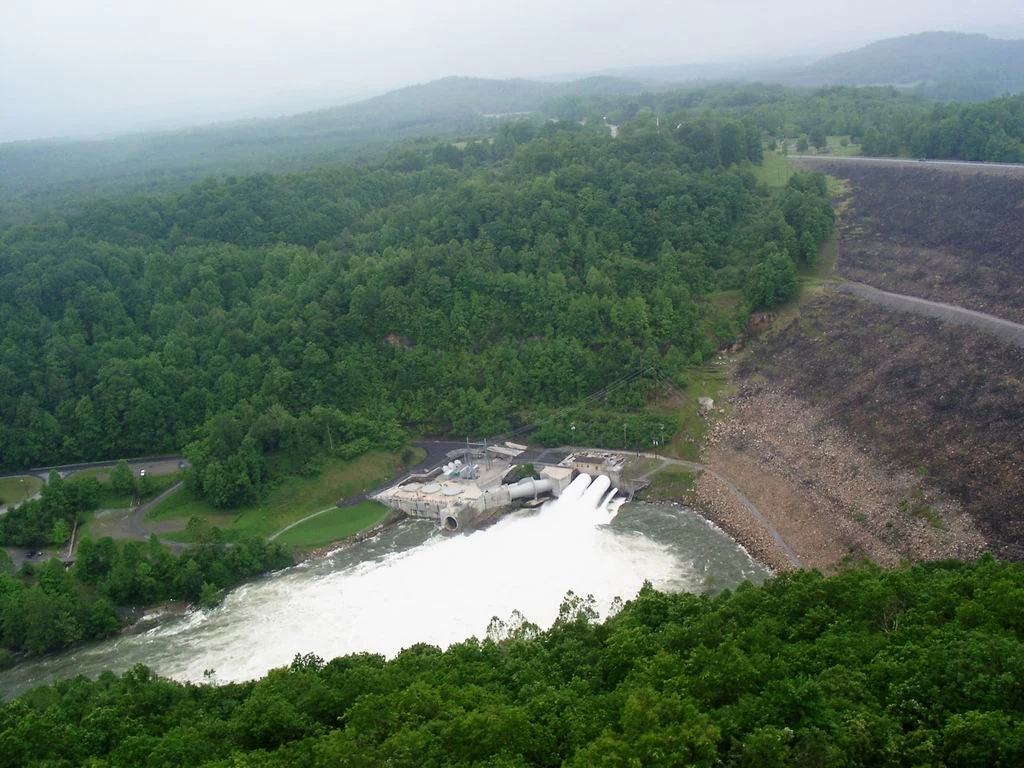
An aerial perspective shows a large rock-fill dam with a spillway discharging a powerful rush of white water into the river below, surrounded by dense green forest in the Appalachian mountains.
Aerial view of the Summersville Dam releasing water into the Gauley River.

Gauley River National Recreation Area history and protected-area timeline

The Gauley River National Recreation Area was established on October 26, 1988, in recognition of the scenic and recreational value of the Gauley River corridor in southern West Virginia. Its creation reflected a growing national interest in protecting free-flowing river systems and their surrounding gorges for both conservation and outdoor recreation.

The park was designed from the outset around the idea of a river-centered experience, with limited road access and an emphasis on preserving the natural character of the canyon. Summersville Dam, already in place upstream, became an integral part of the recreation area's identity because the controlled releases from Summersville Lake produce the seasonal high flows that have made the Gauley famous.

Administration of the recreation area has been linked to the broader management of New River Gorge, eventually operating under the umbrella of New River Gorge National River. This shared oversight reflects the connected role of these Appalachian river systems in regional conservation and recreation policy.

Gauley River National Recreation Area landscape and geographic character

The landscape of the Gauley River National Recreation Area is defined by the deeply cut Appalachian gorge of the Gauley River and the adjoining Meadow River valley. The terrain belongs to the Appalachian Plateau, where ancient sandstones and related sedimentary layers have been eroded by rivers into narrow, often steep-sided canyons bordered by forested ridges and benches.

Within the protected corridor, the river is flanked by boulder fields, rock outcrops, vertical cliff faces, and tributary hollows that descend sharply from ridges above. The channel itself is a working riverbed, shaped by high seasonal flows, large embedded boulders, and continuously shifting gravel bars and pools. Outside of the river corridor, the uplands carry mixed hardwood forest typical of West Virginia's mountain country, with hemlock along cooler drainages and patches of oak, hickory, maple, and other Appalachian hardwoods on the slopes above.

Because most of the area cannot be reached by road, the landscape reads as a continuous band of forested canyon and river. The only major road-accessible feature is Summersville Dam at the upstream end, where the impoundment of Summersville Lake provides a calmer contrast to the wild whitewater downstream and serves as the principal launch corridor for river trips.

Gauley River National Recreation Area ecosystems, habitats, and plant life

Ecologically, the Gauley River National Recreation Area represents a classic Appalachian river-gorge system, where aquatic habitat, cliffs, and upland forest together form an interconnected natural corridor. The Gauley and Meadow rivers themselves support freshwater communities adapted to the high seasonal flows, cool temperatures, and rocky substrates characteristic of central Appalachian streams.

The forests above the river belong to the mixed mesophytic and oak-hickory forest types common to the southern Appalachian region. Hardwood communities dominate the slopes, with riparian zones along the river and tributary streams providing a softer edge to the canyon. Hemlock stands and rhododendron thickets appear in cooler, sheltered drainages, contributing to the layered plant communities visible from the water.

The combination of high-canopy forest, shaded cliffs, cool water, and varied microhabitats makes the recreation area a cohesive natural corridor despite its relatively narrow footprint. The protected status of the corridor helps maintain water quality, streamside cover, and the broader ecological character of one of West Virginia's signature river valleys.

Gauley River National Recreation Area wildlife and species highlights

Wildlife within the Gauley River corridor is shaped by the same conditions that define the landscape: steep forested slopes, a free-flowing river, and limited human access. The mix of hardwood forest, cliff habitat, and water supports a typical southern Appalachian community of mammals, birds, and aquatic species.

The forested ridges and hollows provide habitat for white-tailed deer, black bear, wild turkey, and smaller mammals such as squirrels and foxes common to West Virginia woodlands. Raptors, including hawks and occasionally eagles, are drawn to the cliffs and the open airspace above the river, where updrafts along the canyon walls provide hunting conditions. Songbird communities occupy both the streamside thickets and the upland forest, contributing to the seasonal character of the corridor.

In the river itself, freshwater fish and other aquatic life benefit from the cooler, well-oxygenated flows maintained by the Gauley's dam-release pattern and free-flowing character on the Meadow River. The combination of forest cover along the banks and relatively uninterrupted river habitat supports a working aquatic system that complements the terrestrial wildlife of the surrounding gorge.

Gauley River National Recreation Area conservation status and protection priorities

The Gauley River National Recreation Area is significant from a conservation standpoint because it protects a substantial stretch of one of West Virginia's major rivers in a region where dams and development have altered many other waterways. By safeguarding both the river and its adjoining canyon from extensive road building and shoreline development, the recreation area preserves the natural processes that shape the Gauley corridor.

Its protection also carries broader Appalachian river-conservation value, since the park links in spirit and management with the New River Gorge unit and other Appalachian waterway protections. Maintaining forest cover along steep slopes is important for watershed health, sediment control, and the integrity of the aquatic habitat below. Limiting road access across most of the area helps preserve the sense of an intact river gorge and reduces the fragmentation that often affects Appalachian valleys.

Gauley River National Recreation Area cultural meaning and human context

The Gauley River corridor is woven into the broader story of Appalachian West Virginia, where rivers have long shaped settlement, industry, and recreation. Communities in Nicholas and surrounding counties developed along these waterways, and the rivers themselves became part of regional identity through hunting, fishing, logging-era history, and the eventual rise of whitewater recreation.

In more recent decades, the Gauley has taken on cultural importance among paddlers and outdoor enthusiasts, becoming a defining symbol of West Virginia's whitewater heritage. The names given to individual rapids, like Pillow Rock, Lost Paddle, Iron Ring, and Sweet's Falls, reflect a modern layer of place-based identity built up by generations of rafters and kayakers. Together, these threads of regional history and river-running culture give the recreation area a depth that extends beyond its formal conservation status.

Top sights and standout views in Gauley River National Recreation Area

The strongest single highlight of the recreation area is the whitewater run itself: a roughly 25-mile corridor of the Gauley loaded with Class V rapids that come alive under the fall dam-release schedule. Summersville Dam, as both an anchor feature and the source of those releases, provides the only road-accessible viewpoint within the unit and frames the experience for visitors launching downstream.

A second highlight is the contrast between the roadless gorge and the surrounding Appalachian landscape, where dense forest and steep canyon walls create a sense of remoteness unusual in the eastern United States. The inclusion of a segment of the Meadow River adds variety, linking the park to additional whitewater and scenery in the same regional river system. Together, these qualities make the recreation area a benchmark eastern destination for river-driven outdoor recreation and a key piece of West Virginia's protected Appalachian river network.

Best time to visit Gauley River National Recreation Area

The recreation area's identity is closely tied to seasonal flow conditions on the Gauley River. Scheduled dam releases from Summersville Lake during the fall months, typically in September and October, produce the high, big-water flows for which the river is best known. This window is the most intense period for whitewater rafting and kayaking and is when the named Class V rapids of the Gauley reach their full character.

Outside of the release season, river flows drop substantially and the experience of the area becomes quieter, with reduced rafting activity and a changed feel on the water. Late spring and early summer bring warmer weather and greener forest canopy, while the surrounding Appalachian hardwoods put on strong fall color alongside the rafting season. Midsummer heat and low water often leave the river at its most subdued, though the canyon scenery and forest environment remain present year-round for those who experience the area by boat or as part of guided trips.

Monthly climate preview

Measured monthly temperature ranges and precipitation averages from 1991 to 2020

Gauley River National Recreation Area Climate Normals and Annual Weather Patterns

Gauley River National Recreation Area exhibits a measured annual cycle of long term average temperatures and monthly precipitation values at a representative coordinate. Accessing the complete twelve month profile reveals detailed variations in temperature extremes and precipitation rhythm across the protected area.
Annual mean10 °C
-2 °C21 °C
Jan-2°
Feb-1°
Mar
Apr10°
May15°
Jun19°
Jul21°
Aug20°
Sep17°
Oct11°
Nov
Dec
Warmest month
July

20.8 °C

Coolest month
January

-2.4 °C

Wettest month
July

3.8 mm/day

Driest month
October

2.4 mm/day

Park location guide

Geography guide, regional context, and park location map for Gauley River National Recreation Area

Gauley River National Recreation Area park geography, regions, and map view in United States of America

Understand where Gauley River National Recreation Area sits in United States of America through a broader geographic reading of the surrounding landscape, nearby location context, and its mapped position within the national park landscape.

How Gauley River National Recreation Area fits into United States of America

The United States of America is a federal presidential republic and one of the world's largest countries by area and population. It consists of 50 states across a vast territory spanning multiple time zones, with its capital in Washington, D.C. and largest city in New York City. The nation has a diverse economy, influential political system, and significant cultural and military presence globally.

Wider geography shaping Gauley River National Recreation Area in United States of America

The United States occupies a vast territory in North America, bordered by Canada to the north and Mexico to the south. The 48 contiguous states stretch from the Atlantic to the Pacific Ocean, while Alaska occupies the northwestern region and Hawaii is an archipelago in the Pacific. The country encompasses diverse terrain including the Rocky Mountains, Appalachian Mountains, Great Plains, and extensive river systems.

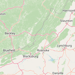
Map view of Gauley River National Recreation Area

Use this park location map to pinpoint Gauley River National Recreation Area in United States of America, understand its exact geographic position, and read its mapped placement within the surrounding landscape more clearly.

Pigeon | © OpenStreetMap contributors

Location context for Gauley River National Recreation Area

West Virginia

Visual reference guide to the steep Appalachian gorge, dense hardwood forests, and river corridors.

Gauley River National Recreation Area Photos and Protected Landscape Scenery

Examine detailed photos of Gauley River National Recreation Area to understand its rugged canyon terrain, boulder-strewn riverbeds, and dense forested slopes. Visual documentation reveals the remote protected landscape character of this West Virginia river corridor more clearly than maps alone.

An aerial perspective shows a large rock-fill dam with a spillway discharging a powerful rush of white water into the river below, surrounded by dense green forest in the Appalachian mountains.

Park atlas

Compare regional mountain terrain, river corridors, and adjacent protected natural areas.

Explore Parks Near Gauley River National Recreation Area and Surrounding Protected Landscapes

Browse other parks near Gauley River National Recreation Area to examine connected regional river systems and rugged Appalachian gorge landscapes. Continuing into adjacent protected areas provides broader geographic context for southern West Virginia mountain ecosystems.
National parkWest Virginia
About 22 km away#1 closest

Southwest

New River Gorge National Park and Preserve: Appalachian River Gorge Protected Landscape Atlas

Mapped terrain and geographic context within West Virginia.

Delve into the protected landscape identity of New River Gorge National Park and Preserve, a significant national park in West Virginia. This page details its role as a protected area, highlighting the dramatic river gorge geography, mapped terrain, and its place within the Appalachian Mountains. Understand the park's boundaries and the natural context that makes it a key destination for geographic discovery and conservation appreciation.

Area
294.64 km²
Established
2020
IUCN
V
Visitors
1.6M annual
Watercolor painting showing layers of soft green hills and mountain ridges fading into a light hazy background.
Protected landscapeWest Virginia
About 23 km away#2 closest

Northeast

Monongahela National Forest: Protected Appalachian Landscapes and Regional Geography

Mapping West Virginia wilderness and mountain terrain

Monongahela National Forest protects nearly one million acres of the central Appalachian Mountains. This massive federally managed landscape is defined by the Allegheny Front, the highest peak in the Allegheny range at Spruce Knob, and iconic geological formations like Seneca Rocks. The region represents a vital intersection of climate, hydrology, and biodiversity in the eastern United States, housing eight distinct wilderness areas and complex high-altitude ecosystems.

Area
3,727.8 km²
Established
1920
Visitors
3M annual
Relief
Mountain
Wildlife reserveVirginia
About 93 km away#3 closest

South

Mountain Lake Wilderness: Protected Appalachian Geography and Mountain Landscapes

High-elevation wetlands and ridge-line geography in Virginia

Mountain Lake Wilderness protects a compact yet biologically diverse landscape where cool, moist conditions support rare mountain bogs and red spruce forests. This protected area along the Eastern Continental Divide features rocky outcrops like White Rocks and War Spur Overlook, providing panoramic views of the surrounding Ridge and Valley terrain within the Jefferson National Forest.

Area
44.66 km²
Established
1984
IUCN
Ib
Relief
Mountain
Wildlife reserveVirginia
About 107 km away#4 closest

East

Rough Mountain Wilderness: Mapping Appalachian Ridges and Protected Terrain

Remote wildlife reserve in western Virginia

Spanning over 9,000 acres, Rough Mountain Wilderness provides a rare example of undisturbed Appalachian forest. The area is characterized by consistently steep slopes, sharp ridgeline topography, and a deep sense of isolation within the George Washington and Jefferson National Forests of western Virginia.

Area
38 km²
Established
1987
IUCN
Ib
Relief
Mountain
A soft, light-toned watercolor illustration of a winding creek flowing through a lush, green landscape with distant rolling hills and scattered trees.
Wildlife reserveBland County
About 113 km away#5 closest

South

Kimberling Creek Wilderness: Geography and Protected Land Boundaries in Bland County

A trail-free Appalachian wilderness reserve in Jefferson National Forest

Kimberling Creek Wilderness represents a significant protected enclave in the central Appalachians of Virginia. This detail covers the steep topography extending from Kimberling Creek to the ridgeline of Hogback Mountain, characterized by sheltered cove forests and diverse oak-hickory stands. The area offers a rare glimpse into recovering eastern old-growth forest ecosystems within an entirely trail-free wilderness environment.

Area
23.99 km²
Established
1984
IUCN
Ib
Relief
Mountain
A wide, panoramic watercolor illustration showing a row of green trees, faint mountains in the background, and grass reeds in the foreground left against a white background.
Wildlife reserveWest Virginia
About 113 km away#6 closest

Northeast

Laurel Fork South Wilderness: Protected Appalachian Highlands and Forested Terrain

High elevation forest and creek drainage geography

Laurel Fork South Wilderness features a dense, unbroken stretch of Appalachian forest within West Virginia. This protected landscape is defined by its deep narrow hollows and high ridgelines, representing a vital example of mid elevation mountain terrain and recovering forest ecosystems within the Monongahela National Forest.

Area
23.41 km²
Established
1983
IUCN
Ib
Relief
Mountain
Wildlife reserveVirginia
About 114 km away#7 closest

East

Rich Hole Wilderness: Appalachian Wildlife Reserve and Forest Geography

Protected cove hardwood forest in western Virginia

Rich Hole Wilderness represents a protected high quality forest landscape located within the James River Ranger District. This area spans steep, narrow hollows and high ridge crests, providing critical habitat and showcasing old growth timber specimens. Use this resource to understand the park terrain, drainage patterns, and its position within the broader Appalachian forest network of western Virginia.

Area
26.1 km²
Established
1988
IUCN
Ib
Relief
Mountain
Wildlife reserveWest Virginia
About 120 km away#8 closest

Northeast

Laurel Fork North Wilderness: Mapping Appalachian Forest and Mountain Terrain

Protected wilderness landscape in the West Virginia highlands.

Laurel Fork North Wilderness sits as a key conservation unit within the Monongahela National Forest. This protected territory preserves a complex of high-elevation hardwood forests and the stream-cut valley of Laurel Fork. By examining this region, users gain insight into the geography of Allegheny mountain wilderness and the persistent character of recovery-focused Appalachian landscapes.

Area
24.5 km²
Established
1983
IUCN
Ib
Relief
Mountain

Common questions about visiting, size, designation, and location context for Gauley River National Recreation Area

Gauley River National Recreation Area FAQs for park facts, access, geography, and protected area context

Find quick answers about Gauley River National Recreation Area, including protected-area facts, park geography, trail and visitor context, and how the park fits into its surrounding country and regional landscape.
MoriAtlas Explorer

Continue Your Protected Areas Search Across the Global Atlas

Deepen your exploration by continuing the structured search for national parks and protected areas worldwide. Utilize the comprehensive filtering capabilities to compare different conservation landscapes and refine your understanding of global park geography. Discover more about the distribution and characteristics of protected natural areas.

Global natural geography