Mori Atlas logo
Wildlife reserveGee Creek Wilderness

Mapping the rugged creek valleys and mixed hardwood forests of this Cherokee National Forest reserve

Gee Creek Wilderness: A Compact Protected Landscape in the Tennessee Appalachian Foothills

Gee Creek Wilderness serves as a protected sanctuary within the southern Appalachian foothills of Tennessee, representing a classic example of mid-elevation mountain terrain. Stretching across Polk and Monroe counties, this managed wilderness preserves a dense network of hardwood and pine forests centered around the riparian corridors of Gee Creek. As the smallest wilderness area within the Cherokee National Forest, the region offers an immersive look at roadless Appalachian geography and concentrated stream-driven ecosystems.

southern AppalachiansAppalachian wildernesswilderness areaCherokee National ForestTennesseePolk County

Gee Creek Wilderness

Wildlife reserve

Park overview

Structured park overview, official facts, and landscape profile for Gee Creek Wilderness

Gee Creek Wilderness park facts, protected area profile, and essential visitor context

Review the core facts for Gee Creek Wilderness, including designation, size, terrain, visitor scale, habitats, and operating context in one park-focused overview.

About Gee Creek Wilderness

Gee Creek Wilderness is a small but ecologically significant protected area in the southern Appalachian region of east Tennessee. Covering about 2,493 acres, it is the smallest of the wilderness areas that fall within the Cherokee National Forest, a vast public land complex that forms the backbone of conservation and outdoor recreation in the Tennessee mountains. Most of Gee Creek lies in Polk County, near the Georgia border, while the northeasternmost corner reaches into Monroe County. The closest town of meaningful size is Etowah, Tennessee, which sits outside the wilderness boundary.

Geographically, the wilderness occupies the foothill landscape that links the higher Smoky Mountains to the north with the rougher plateau country to the south. Its terrain tops out at around 2,560 feet above sea level, a modest elevation by Appalachian standards but one that still produces steep slopes, narrow creek drainages, and the kind of deeply dissected forest topography that defines the southern Appalachians. Water draining from Gee Creek eventually flows westward toward the broader Tennessee River system, through watersheds that have shaped both the ecology and human history of the region.

Despite its small size, Gee Creek plays an outsized role as a representative example of southern Appalachian wilderness. Its protected status, under the United States wilderness preservation system and managed by the US Forest Service, ensures that its forests, streams, and wildlife are shielded from logging, road building, and most forms of modern development. This makes the area valuable as habitat for native plant and animal species, as a benchmark for natural ecological processes in the region, and as a quiet outdoor setting for hiking, wildlife observation, and solitude in a part of Tennessee where large protected wildlands can be hard to find at low elevation.

In a broader sense, Gee Creek Wilderness illustrates how even very small wilderness areas can preserve meaningful chunks of regional landscape character. Within the Cherokee National Forest, it functions as one of several anchor points for the forest's wilderness network, contributing to the long‑term ecological integrity of the southern Appalachians and providing a tangible example of Appalachian wilderness in miniature.

Quick facts and research context for Gee Creek Wilderness

Gee Creek Wilderness is a 2,493‑acre federally designated wilderness in southeastern Tennessee, located primarily in Polk County with a small extension into Monroe County. It lies within the Cherokee National Forest, the largest national forest in Tennessee, and is administered by the United States Forest Service. The wilderness was officially designated in 1975 under the Wilderness Act framework, giving it IUCN Category Ib protection status. Its highest point sits roughly 2,560 feet above sea level, placing it in the lower Appalachian terrain rather than the high peaks of the Great Smokies further east. Gee Creek is notable within the Cherokee National Forest for being the smallest of that forest's designated wilderness areas.

Park context

Deeper park guide and search-rich context for Gee Creek Wilderness

Gee Creek Wilderness history, landscape, wildlife, and travel context

Explore Gee Creek Wilderness through its history, landscape character, ecosystems, wildlife, conservation priorities, cultural context, and seasonal travel timing in a structured park guide built for atlas discovery and search intent.

Why Gee Creek Wilderness stands out

Gee Creek Wilderness is best known as the smallest wilderness area within the Cherokee National Forest, offering a compact example of southern Appalachian wilderness character. It preserves a stretch of forested creek country along Gee Creek and its surrounding ridges in southeastern Tennessee, giving visitors a classic Appalachian mountain experience in a relatively small and accessible footprint. The area's defining identity lies in its combination of mixed hardwood and conifer forest, creek valleys, and Appalachian foothill topography, all maintained under strict wilderness protection. Because it is so compact, Gee Creek concentrates the essential qualities of a larger Cherokee National Forest landscape; quiet, roadless, forested terrain; into a single small preserve. It is also recognized as part of the early wave of wilderness designations in the southern Appalachians, having received federal protection in the mid‑1970s.

Gee Creek Wilderness history and protected-area timeline

Gee Creek Wilderness was officially designated in 1975, placing it among the early wave of wilderness areas set aside in the southern Appalachian region during the mid‑1970s expansion of the National Wilderness Preservation System. Its designation came after years of national debate over how to balance timber production, recreation, road access, and ecological protection on national forest lands. Congress ultimately chose to preserve the Gee Creek drainage and its surrounding ridges as part of the broader wilderness framework that was reshaping the management of national forests across the country.

Once designated, the area was incorporated into the administrative structure of the Cherokee National Forest, which remains its governing institution to this day. The United States Forest Service took responsibility for managing Gee Creek according to wilderness standards, restricting road construction, commercial logging, and motorized access within its boundaries. These restrictions helped the forest recover from any earlier logging, grazing, or settlement impacts that had affected the surrounding landscape prior to federal acquisition.

The 1975 designation also marked a turning point for the southern Cherokee highlands, giving the region a formal wilderness foothold that would later be supplemented by additional wilderness areas within the Cherokee National Forest. Over the decades since, Gee Creek has come to be seen as a small but enduring example of the kind of roadless, ecologically intact terrain that the Wilderness Act was designed to protect. While the area itself is modest in size, its long‑term protected status represents a continuing commitment to preserving Appalachian forest character within a national forest that is otherwise working land.

Gee Creek Wilderness landscape and geographic character

The landscape of Gee Creek Wilderness is classic southern Appalachian foothill country, shaped by long‑term erosion of ancient mountain terrain and the persistent action of small streams cutting into forested ridges. Elevations within the wilderness top out at about 2,560 feet above sea level, putting it firmly within the lower Appalachian zone rather than the high peaks of the Great Smoky Mountains to the northeast. The result is a terrain of rolling ridges, hollows, and steep creek valleys rather than dramatic summits or vertical cliffs.

Water is a defining feature of the area. The wilderness is organized around Gee Creek and its tributaries, which drain the central portion of the preserve. These streams have cut narrow valleys flanked by forested slopes, producing the classic Appalachian pattern of ridge‑top and hollow landscapes. The small scale of the drainage network means that many of the most scenic and ecologically important features of the wilderness; waterfalls, cascades, pools, and sheltered seeps; are concentrated in close proximity, giving the compact area an unusually rich variety of microhabitats for its size.

Surrounding the drainage system, the higher ground carries mixed hardwood and pine forest typical of the southern Cherokee highlands. Below the elevation of about 2,500 feet, the vegetation shifts between ridge‑top oak and hickory stands and more mesic, streamside communities of larger hardwoods. The visual character of the landscape is one of densely forested slopes and creek corridors, with limited openings and almost no evidence of modern development. Because the area is roadless, visitors moving through it experience a continuous, unbroken forest scene that retains the atmosphere of an earlier Appalachian landscape.

Gee Creek Wilderness ecosystems, habitats, and plant life

Gee Creek Wilderness sits within the southern Appalachian mixed mesophytic forest region, one of the most biodiverse temperate forest zones in the world. Although the area is small, its position between creek bottoms and ridge tops produces a striking variety of microhabitats within a compact footprint. Streamside zones support moisture‑loving hardwoods and dense understory vegetation, while drier ridgetops carry more open, sun‑adapted forest communities dominated by oaks, hickories, and pines.

The mosaic of moist hollows, dry slopes, and exposed rock outcrops creates a layered forest environment that has not been subject to timber harvesting or large‑scale development since the area's wilderness designation. This long period of minimal human disturbance has allowed natural stand development, leaf litter accumulation, and the return of large woody debris to streams; all features that increase habitat complexity. Fallen logs, shaded pools, and mature canopy layers make the forest particularly hospitable to amphibians, reptiles, invertebrates, and forest‑interior bird species.

The waterways themselves, including Gee Creek and its smaller tributaries, form the ecological backbone of the wilderness. They support aquatic communities typical of small Appalachian streams, where cool, well‑oxygenated water and extensive forest cover create conditions favorable for native fish, salamanders, and aquatic insects. Surrounding riparian zones also serve as travel corridors and foraging habitat for wildlife moving between the wilderness and adjacent tracts of the Cherokee National Forest, reinforcing Gee Creek's role as a small but ecologically valuable refuge within much larger forested landscape.

Gee Creek Wilderness wildlife and species highlights

Gee Creek Wilderness supports a typical cross‑section of southern Appalachian woodland wildlife, with species adapted to both mature forest interiors and streamside environments. The dense, largely undisturbed canopy provides reliable habitat for forest‑interior songbirds, while the mix of oaks, hickories, and pines on drier ridges produces abundant mast crops that sustain deer, wild turkey, squirrels, and a range of small mammals.

Streams and moist hollows within the wilderness are particularly important for herpetofauna, the reptile and amphibian group for which the southern Appalachians are best known. Cool, shaded creek valleys offer refuge for salamanders, frogs, and other moisture‑dependent species, while the surrounding forest supplies the insects and small invertebrates that fuel broader food webs. Raptors, including hawks, and a variety of owls, are also expected visitors to the area, taking advantage of openings in the canopy and the abundance of small mammal prey.

Because the area is small and surrounded largely by other forested public land, wildlife movement in and out of the wilderness is relatively unimpeded. This connectivity allows the animal community of Gee Creek to function as part of a broader southern Cherokee ecosystem rather than an isolated preserve. For visitors, encounters with wildlife are most likely to take the form of bird songs along the creeks, tracks along forest trails, and the occasional glimpse of deer or turkey in more open hardwood stands, especially at dawn and dusk.

Gee Creek Wilderness conservation status and protection priorities

Gee Creek Wilderness was designated in 1975 under the framework of the National Wilderness Preservation System, giving it one of the strongest levels of long‑term federal land protection available in the United States outside of full national park status. Its classification as IUCN Category Ib reflects this commitment to maintaining the area's ecological character with minimal human intervention. Management is the responsibility of the United States Forest Service, which administers the wilderness as part of the broader Cherokee National Forest.

From a conservation standpoint, the area's foremost value lies in its role representing southern Appalachian forest ecology in a compact, roadless setting. Although it is small in absolute terms, Gee Creek protects a complete watershed mosaic of ridge, slope, and hollow forest communities, along with the creek that ties them together. Such intact, contiguous habitat patches are increasingly important in a region where low‑elevation forest has historically been subject to fragmentation by agriculture, logging, and development.

The wilderness also contributes to landscape‑scale conservation within the Cherokee National Forest. Because it sits within a much larger matrix of federally managed public land, its protected status helps anchor broader ecological functions, including the preservation of natural stream flow regimes, the maintenance of forest interior conditions, and the safeguarding of habitat connectivity for wide‑ranging species. In this sense, even a small wilderness like Gee Creek offers disproportionate conservation value per acre, supporting both regional biodiversity and the long‑term resilience of Appalachian forests in the face of environmental change.

Top sights and standout views in Gee Creek Wilderness

Gee Creek Wilderness stands out within the Cherokee National Forest for being that forest's smallest designated wilderness, concentrating Appalachian forest and creek scenery into a compact, walkable preserve. Its 1975 wilderness designation places it among the early protected landscapes of the southern Appalachians, and its stewardship by the United States Forest Service has maintained its roadless, undeveloped character for decades.

The area's strongest features include its Gee Creek drainage and its surrounding mixed hardwood and pine ridges, which together form a representative cross‑section of southern Appalachian forest types. Its mid‑range elevations, combined with continuous forest cover and minimal modern infrastructure, give visitors an unusually immersive experience of Appalachian wilderness in a small natural area.

Best time to visit Gee Creek Wilderness

Gee Creek Wilderness can be visited throughout much of the year, but most visitors will find the experience most rewarding during spring and autumn, when cooler temperatures and changing forest conditions make the small preserve especially atmospheric. In spring, wildflowers and flowering trees brighten the creek bottoms and lower slopes, and the area comes alive with bird song as migratory species return to the southern Appalachians.

Autumn brings peak fall foliage to the mixed hardwood canopy, turning the ridges and hollows of Polk County into broad displays of red, orange, and gold. Because the wilderness sits at relatively low elevations, leaves here generally change earlier than in the higher Great Smoky Mountains to the northeast, making Gee Creek a good early‑season destination for autumn color. Summer visits are also possible, though the dense forest cover, humidity, and warm temperatures typical of the region mean that hikers should be prepared for heat and insects. Winter tends to be relatively mild in this part of Tennessee, with occasional light snowfall that can briefly transform the creek valleys before melting away.

Monthly climate preview

Long-term representative temperature and precipitation averages for Tennessee terrain

Gee Creek Wilderness Climate Normals and Monthly Weather Patterns

Gee Creek Wilderness records long-term monthly temperature averages ranging from cooler winter lows to warm summer maximums alongside consistent daily precipitation rates. Examining the full twelve-month profile provides complete historical climate data for this protected coordinate.
Annual mean15 °C
3 °C26 °C
Jan
Feb
Mar
Apr14°
May19°
Jun24°
Jul26°
Aug25°
Sep22°
Oct15°
Nov
Dec
Warmest month
July

25.7 °C

Coolest month
January

3.2 °C

Wettest month
February

4.4 mm/day

Driest month
October

2.6 mm/day

Park location guide

Geography guide, regional context, and park location map for Gee Creek Wilderness

Gee Creek Wilderness park geography, regions, and map view in United States of America

Understand where Gee Creek Wilderness sits in United States of America through a broader geographic reading of the surrounding landscape, nearby location context, and its mapped position within the national park landscape.

How Gee Creek Wilderness fits into United States of America

The United States of America is a federal presidential republic and one of the world's largest countries by area and population. It consists of 50 states across a vast territory spanning multiple time zones, with its capital in Washington, D.C. and largest city in New York City. The nation has a diverse economy, influential political system, and significant cultural and military presence globally.

Wider geography shaping Gee Creek Wilderness in United States of America

The United States occupies a vast territory in North America, bordered by Canada to the north and Mexico to the south. The 48 contiguous states stretch from the Atlantic to the Pacific Ocean, while Alaska occupies the northwestern region and Hawaii is an archipelago in the Pacific. The country encompasses diverse terrain including the Rocky Mountains, Appalachian Mountains, Great Plains, and extensive river systems.

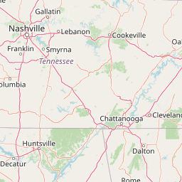
Map view of Gee Creek Wilderness

Use this park location map to pinpoint Gee Creek Wilderness in United States of America, understand its exact geographic position, and read its mapped placement within the surrounding landscape more clearly.

Pigeon | © OpenStreetMap contributors

Location context for Gee Creek Wilderness

Polk CountyTennessee
Recorded earthquake history

Examine Recorded Earthquake History Near Gee Creek Wilderness

Review documented seismic occurrences associated with the surrounding terrain of Gee Creek Wilderness. This record allows for an in depth exploration of historical events, magnitudes, and epicentre distances in the Southern Appalachian highlands through the MoriAtlas catalogue.

Gee Creek Wilderness Earthquake History

Catalogued events

30 events

Strongest magnitude

Magnitude 4.4

Most recent event

Dec 12, 2018

This history includes earthquakes recorded inside the park or within 50 km of its borders

Park atlas

Compare adjacent forest reserves, ridge terrain, and regional wilderness tracts.

Parks Near Gee Creek Wilderness and Surrounding Appalachian Protected Areas

Explore other protected areas near Gee Creek Wilderness to examine related Appalachian foothill topography and forest ecosystems. Comparing adjacent public lands reveals broader regional conservation patterns across the surrounding Tennessee highlands.
A horizontal watercolor painting depicting a soft green landscape with rolling hills, a meandering stream, and foreground grasses against a light white background.
Protected landscapeNorth Carolina
18 km away#1 closest

East

Nantahala National Forest: Geographic Overview of Protected Appalachian Mountain Landscapes

Mapping deep river gorges and temperate rainforests in North Carolina

The Nantahala National Forest represents a significant conservation achievement, encompassing diverse southern Appalachian mountain terrain. The landscape features deep river gorges, ancient old-growth forests, and extensive networks of waterfalls. This overview provides mapped context on its vast wilderness areas, including Joyce Kilmer-Slickrock, and the long-distance trail corridors that traverse this temperate rainforest region.

Area
2,150 km²
Established
1920
Relief
Mountain
Climate
Temperate
A horizontal watercolor painting showing a soft, impressionistic landscape with mature trees in the foreground, rolling green hills in the midground, and faded purple mountain silhouettes in the distance against a white background.
Wildlife reserveNorth Carolina
44 km away#2 closest

East

Joyce Kilmer-Slickrock Wilderness: Mapped Topography and Protected Forest Boundaries

Old-growth Appalachian wilderness in North Carolina

Analyze the dramatic valley-and-ridge geography of the Joyce Kilmer-Slickrock Wilderness. This protected area, encompassing the rare Joyce Kilmer Memorial Forest, serves as a vital reference for eastern forest conservation, featuring ancient hardwood groves and sweeping mountain vistas across the Unicoi range.

Area
70 km²
Established
1975
IUCN
Ib
Relief
Mountain
National parkTennessee
50 km away#3 closest

East

Great Smoky Mountains National Park: Exploring Its Protected Landscape and Regional Geography

Tennessee's premier national park, mapped for landscape discovery.

Delve into the protected area identity of Great Smoky Mountains National Park, a significant natural landmark within Tennessee. This page provides detailed context on its mountainous terrain, mapped ecological zones, and its foundational role in the broader geography of eastern North America. Understanding the park's specific protected landscape features and its geographic setting is essential for appreciating its unique conservation value.

Area
2,114.15 km²
Established
1934
IUCN
II
Visitors
12.2M annual
A wide watercolor painting showing a landscape of green rolling hills with trees in the foreground and layers of purple mountains in the background against a white background.
Protected areaGilmer County
55 km away#4 closest

South

Rich Mountain Wilderness: Mapping Appalachian Ridges and Protected Terrain in Georgia

Explore the high-elevation forests of Gilmer County.

Rich Mountain Wilderness encompasses nearly 9,500 acres of undisturbed Appalachian mountain landscape. Characterized by its signature 4,050-foot peak and unique porter's loam soils, the area supports a diverse forest ecosystem shielded under federal wilderness protection within the Chattahoochee National Forest.

Area
38.35 km²
Established
1986
IUCN
Ib
Relief
Mountain
A soft watercolor illustration depicting a landscape of rolling hills and mountain silhouettes in shades of green, yellow, and faint red against a white background.
Protected landscapeGeorgia
About 74 km away#5 closest

South

Ed Jenkins National Recreation Area and Southern Appalachian Mountain Geography

Protected forested ridges and trail gateway in northern Georgia

Covering over 23,000 acres, this protected area features the iconic southern terminus of the Appalachian Trail at Springer Mountain. The unit preserves a dense tapestry of hardwood forests, rolling ridges, and spring-fed stream valleys, representing a core portion of the Blue Ridge mountain range's continuous landscape in northern Georgia.

Area
94.4 km²
Established
1991
Relief
Mountain
Climate
Temperate
A pale, minimalist watercolor painting showing layers of soft green hills and a gentle stream against a white background.
Wildlife reserveGeorgia
78 km away#6 closest

Southeast

Raven Cliffs Wilderness: Exploring the Appalachian Ridges and Protected Forest Landscapes

High-elevation wilderness area in northern Georgia.

Spanning steep ridges and narrow valleys, Raven Cliffs Wilderness represents a significant protected area within the Chattahoochee National Forest. The landscape transitions from high, exposed ridgelines to dense hardwood forest, offering a compact yet varied study in Appalachian mountain geography.

Area
36.89 km²
Established
1986
IUCN
Ib
Relief
Mountain
Protected landscapeSouth Carolina
119 km away#7 closest

East

Sumter National Forest: Mapping Protected Landscapes and Terrain in South Carolina

Bridging Piedmont forests and Appalachian mountain foothills

Sumter National Forest offers a study in geographic contrast, as its three districts span the transition from South Carolina Piedmont ridges to the rugged spurs of the Blue Ridge Mountains. This protected area features the Chattooga Wild and Scenic River corridor, expansive hardwood-conifer mosaics, and complex mountain watersheds. The forest provides a window into regional land restoration, where reclaimed farmland and mountain ridges now form a continuous network of protected natural terrain.

Area
1,500.98 km²
Established
1936
Relief
Mixed relief
Climate
Temperate
A soft watercolor illustration depicting a winding river, a small waterfall over layered rocks, and distant rolling mountains in muted green, blue, and brown tones.
Wildlife reserveUnited States of America
125 km away#8 closest

East

Ellicott Rock Wilderness: Geographic and Historic Protected Landscape Overview

A rare tri-state wilderness in the Southern Appalachian Mountains

Discover the mapped terrain of Ellicott Rock Wilderness, a protected area defined by its steep river gorges, dense cove forests, and unique position at the tripoint of three U.S. states. This wilderness area preserves the Chattooga River corridor and historic survey landmarks within the southern Blue Ridge Mountains, offering deep insight into the regional geography of the American southeast.

Area
33.48 km²
Established
1975
IUCN
Ib
Relief
Mountain

Common questions about visiting, size, designation, and location context for Gee Creek Wilderness

Gee Creek Wilderness FAQs for park facts, access, geography, and protected area context

Find quick answers about Gee Creek Wilderness, including protected-area facts, park geography, trail and visitor context, and how the park fits into its surrounding country and regional landscape.
MoriAtlas Explorer

Continue Your Protected Areas Search Across the Global Atlas

Deepen your exploration by continuing the structured search for national parks and protected areas worldwide. Utilize the comprehensive filtering capabilities to compare different conservation landscapes and refine your understanding of global park geography. Discover more about the distribution and characteristics of protected natural areas.

Global natural geography