

Mori Atlas logo
Nature reserveGeegeela Conservation Park

Mapping native woodland regeneration and habitat corridors within the Limestone Coast region

Geegeela Conservation Park: A Protected Landscape and Ecological Refuge in South Australia

Geegeela Conservation Park serves as a vital protected area in South Australia, representing a successful transition from agricultural land to restored native ecosystems. The landscape encompasses a diverse mosaic of desert banksia heath, blue gum woodlands, and brown stringybark vegetation, providing essential habitat for threatened fauna including the south-eastern red-tailed black cockatoo. This nature reserve offers deep insight into regional conservation and the importance of preserving remnant biodiversity within a wider, cleared rural environment.

conservation parkSouth Australiabanksia heatheucalypt woodlandstringybark woodlandLimestone Coast

Geegeela Conservation Park

Nature reserve

Park overview

Structured park overview, official facts, and landscape profile for Geegeela Conservation Park

Geegeela Conservation Park park facts, protected area profile, and essential visitor context

Review the core facts for Geegeela Conservation Park, including designation, size, terrain, visitor scale, habitats, and operating context in one park-focused overview.

About Geegeela Conservation Park

Geegeela Conservation Park is a compact protected area in the south-east of South Australia, located in the locality of Bangham in the Hundred of Geegeela to the west of the Bordertown-Frances Road. The nearest town is Frances, with the park situated roughly twelve kilometres north-west of the Frances town centre. The surrounding region is part of the broader Limestone Coast of South Australia and is dominated by agricultural land use, a context that shapes the park's role as an island of remnant and regenerating native habitat within a largely cleared rural matrix.

The land that now makes up the conservation park has a layered history of pastoral and arable use. During the 1960s an area in the south-western corner was cleared and sown with native grasses for grazing, which continued for a number of years. Around 1970 cultivation was attempted on a smaller portion of the property, reportedly with limited success. Agricultural activity later ceased and the cleared land was left to regenerate. The property gained a formal conservation footing in 1986 as a private Heritage Agreement area under the Native Vegetation Management Act 1985, and was proclaimed a sanctuary in 1992 before being upgraded to conservation park status in 2005.

The vegetation of the park is dominated by three principal community types: desert banksia heath, an open woodland of blue gum and pink gum, and an open woodland and wetland system of brown stringybark. Small additional patches include woodland dominated by rough-barked manna gum, river red gum, and buloke. These communities, particularly the mature stringybark and gum woodlands, are ecologically significant because they support breeding habitat for hollow-dependent species such as the south-eastern red-tailed black cockatoo.

The park was proclaimed under the National Parks and Wildlife Act 1972 on 21 July 2005, with land acquired partly through support from the Australian Government's Natural Heritage Trust. Its name, approved by the Surveyor General of South Australia in 2003, is drawn from both the Hundred of Geegeela and the original 'Geegeela Old Station' homestead. It is managed by the South Australian Department for Environment and Water and is classified as an IUCN Category III protected area. The park is not promoted as a major visitor destination, with visitation described as minimal and visitor facilities essentially absent.

Quick facts and research context for Geegeela Conservation Park

Geegeela Conservation Park is situated in the south-east of South Australia, near the small town of Frances and within the gazetted locality of Bangham. It lies in the general Limestone Coast region of the state and is one of the smaller conservation parks in the South Australian reserve system.

The park protects land that was formerly used for pasture and limited cultivation but has been allowed to regenerate into native vegetation since the late twentieth century. Proclaimed as a conservation park in 2005, it is administered by the Department for Environment and Water and is classified under IUCN Category III as a natural monument or feature.

Protection and recognition

Documented terrestrial protection scope and international recognition records

Geegeela Conservation Park Protection Status and Mapped Designations

Geegeela Conservation Park maintains a documented terrestrial protection scope within the global protected area network. Official records outline the baseline designation framework and international recognition status for this conservation landscape.

Protection details

Protection scope
Terrestrial
Transboundary protection
No
Park context

Deeper park guide and search-rich context for Geegeela Conservation Park

Geegeela Conservation Park history, landscape, wildlife, and travel context

Explore Geegeela Conservation Park through its history, landscape character, ecosystems, wildlife, conservation priorities, cultural context, and seasonal travel timing in a structured park guide built for atlas discovery and search intent.

Why Geegeela Conservation Park stands out

Geegeela Conservation Park is best known for protecting a mosaic of native vegetation communities within a cleared agricultural landscape, including desert banksia heath, blue gum, pink gum, and brown stringybark woodlands together with small wetland patches. The park is also notable for providing habitat for the south-eastern red-tailed black cockatoo, a nationally endangered subspecies whose survival depends on retaining mature eucalypt and stringybark woodland across south-eastern South Australia. The park's vegetation, which has regenerated from former pasture and cultivation land, illustrates how former rural land can revert to ecologically valuable native habitat when grazing and cropping pressures are removed. This combination of recovery habitat, threatened-species value, and small protected-area status gives Geegeela a focused conservation rather than tourism identity.

Geegeela Conservation Park history and protected-area timeline

The land that now forms Geegeela Conservation Park has a long transition from purely agricultural use to formal nature conservation. Although the surrounding Hundreds were opened up for farming in the colonial and post-colonial periods, parts of this particular property were progressively retired from grazing and cultivation during the second half of the twentieth century.

During the 1960s an area of about two hundred hectares in the south-western corner of what would later become the park was cleared and sown with a pasture of native grasses, which was grazed for several years. Around 1970 a smaller area of roughly seventy hectares was cultivated, although historical accounts suggest this venture had limited agricultural success. Following these attempts, agricultural activity on the land was abandoned and the cleared areas were allowed to regenerate naturally.

The property's formal conservation history began in 1986, when it was recognised as a private Heritage Agreement area under South Australia's Native Vegetation Management Act 1985. After a change of ownership in the early 1990s, the incoming owners chose to retain the property as a private conservation area, and in 1992 a portion of the land was proclaimed as a sanctuary under the National Parks and Wildlife Act 1972. The final step came in 2005, when the South Australian Government acquired the broader property with assistance from the Australian Government's Natural Heritage Trust and proclaimed it as Geegeela Conservation Park on 21 July 2005. The park's name, approved in 2003, reflects both the cadastral Hundred of Geegeela and the historic 'Geegeela Old Station' homestead on the property.

Geegeela Conservation Park landscape and geographic character

Geegeela Conservation Park occupies a relatively small parcel of land in the south-east of South Australia, within the gently undulating country characteristic of the upper Limestone Coast and Wimmera-influenced landscapes near the Victorian border. The park sits west of the Bordertown-Frances Road in the locality of Bangham, in a region otherwise dominated by cleared farmland, pasture, and remnants of roadside vegetation.

The terrain itself is low and undulating rather than dramatic, with no major rivers, escarpments, or coastlines within the park. The Hundred of Geegeela cadastral unit in which the park sits reflects the surveyed pastoral landscape of nineteenth-century South Australia, and the park itself is simply composed of two adjoining land sections set aside within that broader framework.

Within this modest terrain the park supports a striking mosaic of vegetation, with desert banksia heath, stringybark woodland, and gum woodland creating visually distinct patches across the property. Small wetland areas, formed within the open brown stringybark woodland, add variation to the otherwise dry landscape. The combination of low, farmed surrounds with regenerating native vegetation, mature woodland, and shrubland gives the park a quiet but ecologically varied character.

Geegeela Conservation Park ecosystems, habitats, and plant life

The park's ecological identity is built around the recovery and protection of native vegetation communities in a landscape that has otherwise been extensively cleared for agriculture. Three principal vegetation types dominate the reserve: desert banksia heath, an open woodland of blue gum and pink gum, and an open woodland and wetland mosaic of brown stringybark. Smaller patches of woodland dominated by rough-barked manna gum, river red gum, and buloke contribute additional habitat diversity.

The desert banksia heath is particularly characteristic of sandy soils in the south-east of South Australia and provides important shrub-layer habitat for nectar-feeding birds, insects, and small mammals. The blue gum and pink gum open woodland represents a more open, eucalypt-dominated layer, while the brown stringybark woodlands, with their associated wetlands, contribute both mature tree habitat and seasonally variable wet areas within an otherwise dry environment.

Because much of the park has regenerated from former pasture and cultivation, its vegetation demonstrates an example of native vegetation recovery following the removal of agricultural pressure. This recovery context gives the park a particular conservation profile, as it shows how a former rural landscape can, over decades, develop into habitat of conservation value at both state and national levels.

Geegeela Conservation Park wildlife and species highlights

Wildlife is one of the park's principal conservation values, with surveys recording ninety native avifauna species and five mammal species within the reserve, all identified as having state conservation significance under South Australian frameworks. The high count of bird species reflects the diversity of habitat types present, with heath, woodland, and wetland patches each supporting different bird communities.

The most significant species recorded is the south-eastern red-tailed black cockatoo, a subspecies listed as nationally endangered under the Environment Protection and Biodiversity Conservation Act 1999. This cockatoo depends on large hollow-bearing eucalypts and stringybark trees for breeding, making the park's mature brown stringybark and gum woodlands particularly important even at this small landscape scale.

Beyond the red-tailed black cockatoo, the mix of banksia heath, open eucalypt woodland, and seasonal wetland contributes to habitat for a wider range of woodland and heath-dependent birds, as well as small native mammals that depend on intact shrub and ground layers. The park's ecological value lies less in charismatic large mammals and more in its role as a refuge for birdlife and smaller fauna within a heavily cleared agricultural landscape.

Geegeela Conservation Park conservation status and protection priorities

Geegeela Conservation Park is significant chiefly for its role in conserving native vegetation communities and habitat for threatened fauna within a region otherwise dominated by agriculture. By protecting an area of desert banksia heath and mature eucalypt woodland, the park helps maintain ecological connectivity and habitat resilience in a part of South Australia where natural vegetation cover has been substantially reduced.

The park's most important conservation function relates to the south-eastern red-tailed black cockatoo, a nationally endangered subspecies that requires large hollow-bearing trees for nesting. The retention of mature brown stringybark, blue gum, pink gum, and rough-barked manna gum woodland within the park contributes directly to the protection of breeding and foraging habitat for this species.

The conservation story of the park is also one of land-use transition. The progressive retirement of cropping and grazing pressure, recognition as a private Heritage Agreement area, declaration as a sanctuary in 1992, and ultimate proclamation as a conservation park in 2005 reflect a layered approach to conservation management that combines private stewardship with public protection. Its IUCN Category III classification recognises it as a natural monument or feature, and the park is managed by the Department for Environment and Water under the National Parks and Wildlife Act 1972.

Geegeela Conservation Park cultural meaning and human context

The cultural and human context of Geegeela Conservation Park is closely tied to the pastoral history of south-eastern South Australia. The park takes its name from the historic 'Geegeela Old Station' homestead and from the Hundred of Geegeela, the nineteenth-century cadastral division that shaped land use across the region. These naming elements reflect the legacy of European pastoral settlement in the Limestone Coast region.

The property itself illustrates the transition from active farming, including native grass pasture and short-lived cultivation attempts in the 1960s and 1970s, to landscape regeneration and formal conservation protection. In this sense the park is as much a record of rural land-use change as it is a natural area, capturing a shift from production-oriented farming toward private and then public nature conservation that became more common in Australian rural landscapes from the late twentieth century onward.

Top sights and standout views in Geegeela Conservation Park

Geegeela Conservation Park protects a compact mosaic of three main native vegetation communities: desert banksia heath, blue gum and pink gum open woodlands, and brown stringybark woodland with small wetlands, plus smaller patches of manna gum, river red gum, and buloke woodland.

Faunal highlights include ninety recorded native bird species and five native mammal species of state conservation significance, with the south-eastern red-tailed black cockatoo giving the park particular national-level importance. The 2005 proclamation of the reserve, supported by the Natural Heritage Trust, marked the final step in a transition from private heritage-agreement and sanctuary status to formal conservation park protection within the South Australian reserve system.

Best time to visit Geegeela Conservation Park

Geegeela Conservation Park has minimal visitor use and is not promoted as a major tourist destination, so seasonal visitation considerations are more about ecological character than visitor logistics. The south-east of South Australia generally experiences mild, wetter winters and warm, drier summers, and visits during the cooler months may align with more active bird movement and greener vegetation.

The desert banksia heath and eucalypt woodlands are likely most visually distinctive in spring, when banksias and other native plants are in bloom and woodland bird activity is typically higher. However, given the limited facilities and the park's conservation focus, any visit should be undertaken with the understanding that the reserve is managed primarily for ecological protection rather than recreation.
Monthly climate preview

Long-term representative temperature and monthly precipitation averages for South Australia

Geegeela Conservation Park Climate Normals and Annual Weather Patterns

Geegeela Conservation Park records long-term monthly temperatures ranging from cool winter minimums to high summer maximums alongside measured precipitation levels. Examining the complete twelve-month climatology dataset reveals detailed year-round environmental rhythms across the protected area.
Annual mean15 °C
9 °C22 °C
Jan22°
Feb22°
Mar19°
Apr16°
May12°
Jun10°
Jul
Aug10°
Sep12°
Oct14°
Nov18°
Dec20°
Warmest month
January

22.4 °C

Coolest month
July

9.1 °C

Wettest month
June

2 mm/day

Driest month
February

0.6 mm/day

Park location guide

Geography guide, regional context, and park location map for Geegeela Conservation Park

Geegeela Conservation Park park geography, regions, and map view in Australia

Understand where Geegeela Conservation Park sits in Australia through a broader geographic reading of the surrounding landscape, nearby location context, and its mapped position within the national park landscape.

How Geegeela Conservation Park fits into Australia

Australia is a constitutional monarchy and federal parliamentary democracy comprising six states and ten territories. With a population of nearly 28 million, it is one of the world's most urbanised countries, with most people concentrated on the eastern seaboard. The country has a high Human Development Index and is known for its cultural diversity, ancient Aboriginal heritage, and unique wildlife.

Wider geography shaping Geegeela Conservation Park in Australia

Australia occupies the entire Australian continent, the island of Tasmania, and numerous smaller islands. It is the world's flattest and driest inhabited continent, featuring vast deserts in the interior (the Outback), tropical rainforests along the eastern coast, and a coastline bordering the Indian and Pacific Oceans.

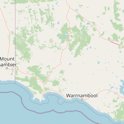
Map view of Geegeela Conservation Park

Use this park location map to pinpoint Geegeela Conservation Park in Australia, understand its exact geographic position, and read its mapped placement within the surrounding landscape more clearly.

Pigeon | © OpenStreetMap contributors

Location context for Geegeela Conservation Park

South Australia
Park atlas

Compare surrounding natural habitats and connected regional conservation landscapes

Other Parks Near Geegeela Conservation Park and Regional Protected Areas

Browsing other protected areas near Geegeela Conservation Park reveals wider ecological patterns across the upper Limestone Coast. Comparing adjacent woodland reserves and regional habitats provides valuable context for understanding local conservation networks.
National parkAustralia
About 10 km away#1 closest

East

Little Desert National Park: Victoria's Semi-Arid National Park and Protected Landscape

Explore mapped boundaries and unique mallee heathland ecosystems.

Delve into the protected landscape of Little Desert National Park, a significant national park covering over 1,300 square kilometers of Victoria's semi-arid western region. This area is characterized by its deep sandy soils, mallee heathlands, and diverse wildlife, including important populations of native birds. Understanding its geographic setting and mapped boundaries provides crucial insight into Australia's conservation efforts and the preservation of unique desert ecosystems.

Area
1,326.47 km²
Established
1988
IUCN
II
Visitors
50K annual
Wildlife reserveSouth Australia
About 22 km away#2 closest

North

Custon Conservation Park: Protected Wildlife Reserve and Woodland Landscape in South Australia

Geographic atlas of protected native grassy woodlands and local biodiversity reserves

Custon Conservation Park represents a vital protected land parcel within South Australia, focused on the conservation of endangered Grey-box Grassy Woodland. The site acts as a specialized wildlife reserve where native vegetation associations are preserved through integrated ecological strategies. This detail page offers insight into the park boundaries and regional environmental context of this significant Limestone Coast protected area.

Area
0.64 km²
Established
2007
IUCN
III
Relief
Lowland
Nature reserveSouth Australia
About 24 km away#3 closest

Southwest

Grass Tree Conservation Park: A Protected Nature Reserve in South Australia

Geography and native woodland map exploration.

Grass Tree Conservation Park is a 16 hectare nature reserve in the Limestone Coast of South Australia, focused on the protection of iconic grass trees. The reserve captures a landscape of calcarenite dunes and diverse forest communities, including brown stringybark and pink gum. Through its protected status, it offers valuable insight into the native vegetation and sandy terrain typical of the West Naracoorte Range.

Area
0.16 km²
Established
1972
IUCN
III
Relief
Lowland
Nature reserveSouth Australia
About 42 km away#4 closest

Southwest

Fairview Conservation Park: Protected Nature Reserve and Limestone Coast Geography

Mapped wetlands, sandy ridges, and woodlands in southeastern South Australia

Explore the geographic framework of Fairview Conservation Park, a nature reserve in South Australia's Limestone Coast. The protected area features a unique intersection of semi-permanent lagoons, periodically inundated flats, and varied woodland vegetation including blue gum and manna gum, offering a clear window into the regional geological and ecological character of the area.

Area
13.94 km²
Established
1960
IUCN
Ia
Relief
Lowland
National parkSouth Australia
About 42 km away#5 closest

South

Naracoorte Caves National Park: Detailed Map and Protected Landscape Context in South Australia

Explore its unique protected geography and natural terrain.

Naracoorte Caves National Park represents a vital protected area within the diverse geography of South Australia. This entry provides an atlas-driven perspective, highlighting its identity as a national park, its mapped landscapes, and its regional significance. Engage with structured information detailing the park's protected status and geographic features, offering a clear view of its contribution to South Australia's natural heritage.

Area
6.6 km²
Established
2001
IUCN
II
Visitors
90.8K annual
State or regional parkSouth Australia
About 48 km away#6 closest

West

Desert Camp Conservation Park: Geographic Overview and Protected Area Atlas

Interdunal plains and pink gum woodland in South Australia

Examine the unique geomorphology and protected vegetation of Desert Camp Conservation Park. This record details the park's characteristic sandy duplex soils, low dune ridges, and granite outcrops, offering insight into the specific ecosystems preserved within this South Australian regional conservation area.

Area
0.51 km²
Established
1967
IUCN
III
Relief
Lowland
Nature reserveSouth Australia
About 52 km away#7 closest

South

Hacks Lagoon Conservation Park: Wetland Landscape and Protected Area Geography

A vital Ramsar wetland site in the South Australia Limestone Coast region

Hacks Lagoon Conservation Park provides a protected freshwater sanctuary amidst the rural plains of South Australia. This nature reserve sustains a diverse wetland habitat, encompassing open water, marshes, and seasonally flooded zones that support critical waterbird populations within an internationally recognized ecological system.

Area
2.02 km²
Established
1967
IUCN
IV
Relief
Lowland
Nature reserveSouth Australia
About 54 km away#8 closest

Northwest

Christmas Rocks Conservation Park: Exploring Granite Outcrops in South Australia

A vital nature reserve and geological monument site

Located in the Limestone Coast region, Christmas Rocks Conservation Park preserves a rare granite landform that rises above the surrounding rural plains. The site functions as a protected natural monument, offering insights into the ancient geological history of South Australia while providing essential habitat for endangered native flora like the Monarto mintbush.

Area
0.19 km²
Established
2014
IUCN
III
Relief
Upland

Common questions about visiting, size, designation, and location context for Geegeela Conservation Park

Geegeela Conservation Park FAQs for park facts, access, geography, and protected area context

Find quick answers about Geegeela Conservation Park, including protected-area facts, park geography, trail and visitor context, and how the park fits into its surrounding country and regional landscape.
MoriAtlas Explorer

Continue Your Protected Areas Search Across the Global Atlas

Deepen your exploration by continuing the structured search for national parks and protected areas worldwide. Utilize the comprehensive filtering capabilities to compare different conservation landscapes and refine your understanding of global park geography. Discover more about the distribution and characteristics of protected natural areas.

Global natural geography