
Mori Atlas logo
Nature reserveGimpelfang

A study of ancient deciduous woodland ecosystems, brook forest corridors, and granite terrain.

Gimpelfang Nature Reserve: Mapped Protected Landscapes and Forest Geography in Sachsen

Gimpelfang represents a significant nature reserve in the Saxon Switzerland region, preserving a rare mosaic of ancient deciduous forest that resisted nineteenth-century spruce reforestation. Centered on the Mannsgraben brook, the area features a complex landscape of ash, alder, and beech stands rooted in granite substrate. This protected zone serves as a vital ecological corridor, supporting diverse woodland bird species and the hazel dormouse within its strictly managed boundaries.

nature reserveSaxon Switzerlanddeciduous forestbrook forestbeech foresthazel dormouse
A flat vector illustration of a valley between steep mountain cliffs with a waterfall in the center, framed by silhouetted forest trees in the foreground.

Gimpelfang

Nature reserve

Park overview

Structured park overview, official facts, and landscape profile for Gimpelfang

Gimpelfang park facts, protected area profile, and essential visitor context

Review the core facts for Gimpelfang, including designation, size, terrain, visitor scale, habitats, and operating context in one park-focused overview.

About Gimpelfang

Gimpelfang is a compact but ecologically dense forest reserve in Saxony, situated on the northern edge of the broader Saxon Switzerland landscape and within the Oberlausitzer Bergland, a transitional highland area between the main Saxon Switzerland sandstone formations and the eastern Ore Mountains. The roughly ten-hectare protected area lies on the flank of the Tanečnice, a mountain whose German name, Tanzplan, echoes a long local cultural history. The terrain combines a moist brook-side corridor along the Mannsgraben with drier slopes that support beech forest and more unusual, hard-to-classify deciduous woodland communities.

The reserve's defining quality is the survival of broadleaf trees that predate the large-scale spruce afforestation campaigns of the 1860s. While the state forestry service reforested most of the slope with Norway spruce beginning in 1862, isolated patches of the older coppice-like Niederwald were left intact, and they now host broadleaf trees more than a hundred and fifty years old. This juxtaposition of old deciduous stands against the surrounding spruce plantation makes Gimpelfang an unusually valuable reference site for understanding how Saxon forest landscapes have changed over the past two centuries.

Ecologically, Gimpelfang sits at the meeting point of several distinct woodland types. The Mannsgraben corridor is dominated by alder and ash in a wet, stream-influenced setting. To the south and east the slopes carry true beech forest, and across the reserve are transitional stands that mix species in combinations not easily assigned to the standard phytosociological forest categories used in central European forestry. The underlying geology is biotite granite of the Seidenberger Granit type, locally mantled by loess-derived loam, which contributes both to the soil conditions favoring broadleaf regeneration and to the mosaic of habitats found on the slope.

Since the late 1990s, the reserve has also been managed with a strict core zone. In 1997, five hectares of the total area were declared a total reserve, in which any form of human intervention, forestry or otherwise, is no longer permitted. Combined with its formal protection since 1961, this makes Gimpelfang one of the more strictly conserved small woodland sites in the Saxon Switzerland-Eastern Ore Mountains district.

Quick facts and research context for Gimpelfang

Gimpelfang is a Saxon nature reserve of approximately ten hectares located on the southeastern slope of the Tanečnice (Tanzplan) above the town of Sebnitz, within the natural region of the Oberlausitzer Bergland.

The reserve sits on biotite granite of the local Seidenberger Granit type, partly covered by loess loam, and it is identified under the German protected-area code D 56 and the international WDPA record 163249. It has held protected status since 1961, and about half of its area has been a strict no-intervention total reserve since 1997.

Protection and recognition

Review official conservation parameters and international database records for Gimpelfang.

Gimpelfang Protection Status and Documented Area Recognition

Gimpelfang holds documented protection records within international conservation databases for geographical analysis. Researchers examine official status histories and administrative metrics associated with this protected area.

Protection details

WDPA ID
163249
Park context

Deeper park guide and search-rich context for Gimpelfang

Gimpelfang history, landscape, wildlife, and travel context

Explore Gimpelfang through its history, landscape character, ecosystems, wildlife, conservation priorities, cultural context, and seasonal travel timing in a structured park guide built for atlas discovery and search intent.

Why Gimpelfang stands out

Gimpelfang is best known for its surviving patches of ancient broadleaf forest that escaped the spruce plantings of the late nineteenth century, particularly the near-natural alder and ash brook forest along the Mannsgraben stream. The reserve is also valued for its old-growth herb-layer flora, its breeding bird community including woodpeckers and owls, and the presence of the hazel dormouse. Its small size contrasts with the ecological complexity of its woodland communities, which include beech forest on the southern and eastern slopes and unusual transitional deciduous stands that are difficult to classify into standard forest typologies.
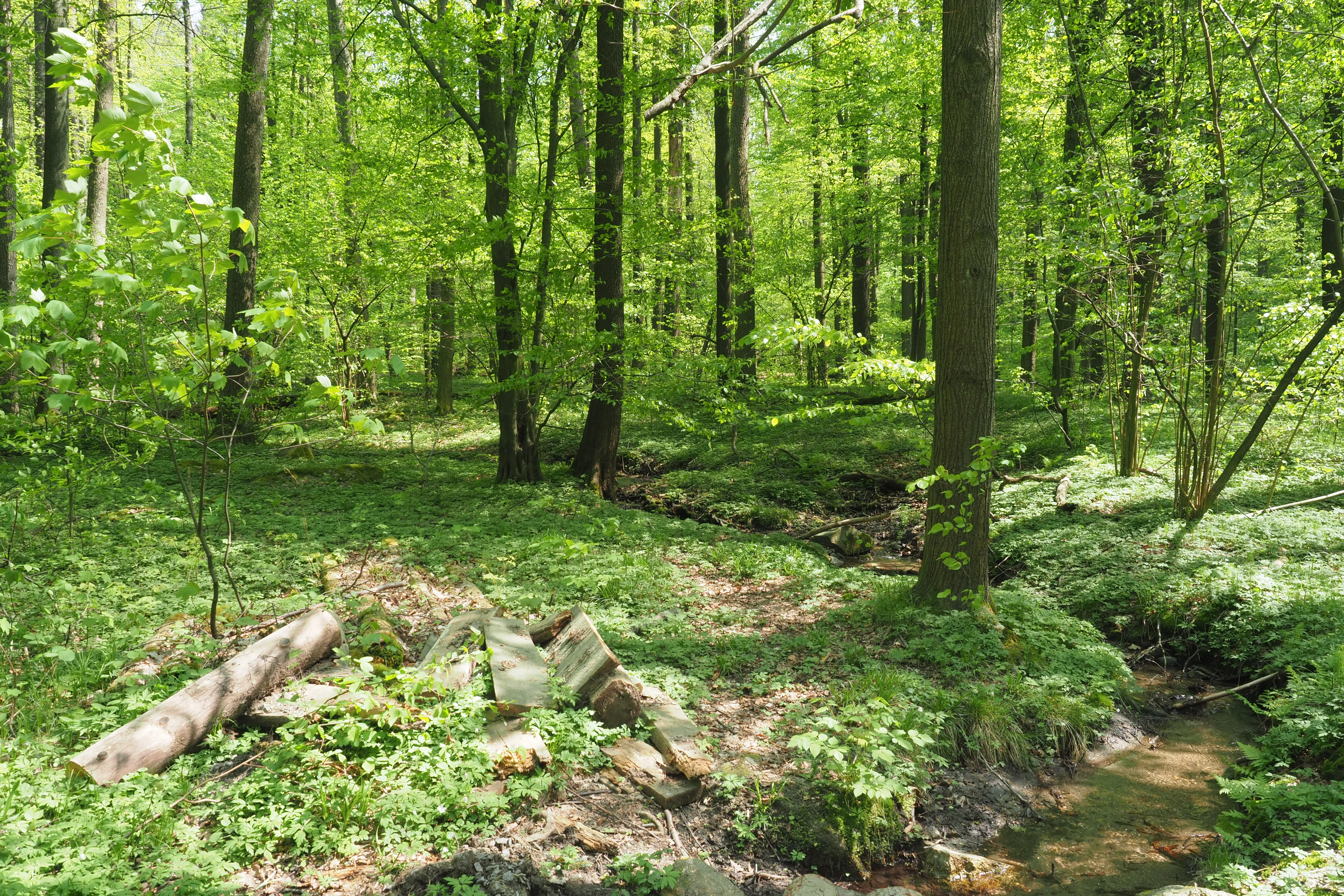
A sunny forest scene featuring vibrant green trees, a small winding stream in the foreground, and fallen logs on the forest floor.
A lush, green forest floor within the Gimpelfang nature reserve, featuring a small stream and dense deciduous canopy.

Gimpelfang history and protected-area timeline

The name Gimpelfang itself is a piece of local history. The field name refers to bird-catching, a form of small-scale, traditional hunting of songbirds that was once practiced on this very slope, and it hints at the heavily wooded, sheltered character of the place. Until the mid-nineteenth century the area was managed as Niederwald, the low-stem coppice woodland once widespread in Saxon hill country, which periodically produced firewood and small timber through rotational cutting.

In 1862, the state forestry administration began replanting most of the slope with spruce, in line with the broader nineteenth-century German push toward conifer forestry for timber and resin. Despite this, scattered patches of the older mixed deciduous forest remained, and these surviving broadleaf stands now contain trees that are more than 150 years old and form the ecological core of today's reserve.

Modern protection began after the Second World War. In 1952, local nature enthusiasts from Sebnitz lobbied the Saxon prime minister Max Seydewitz to set aside the area. In 1958 the district assembly of the former Kreis Sebnitz provisionally secured the site, and on 30 March 1961 the area was formally designated as the Naturschutzgebiet Gimpelfang. Decades later, in 1997, about half of the reserve was declared a strict total reserve in which all further human intervention is excluded, marking a decisive shift toward undisturbed, process-based conservation within the site.

Gimpelfang landscape and geographic character

The landscape of Gimpelfang is essentially a forested hill-slope, shaped by the underlying geology and by historical forest use rather than by dramatic topographic features. The reserve sits on a biotite granite substrate known locally as the Seidenberger Granit, and that bedrock is locally overlaid by loess-derived loam, creating a patchwork of soil conditions across a relatively small area.

The most distinctive terrain element is the Mannsgraben, a small stream that has cut a moist, shaded corridor into the slope. Along this corridor the forest has a distinctly brook-valley character, with soft, damp soils and a tree layer dominated by alder and ash. Away from the stream, on the south- and east-facing slopes, the land rises into true beech forest, while elsewhere the stand composition becomes mixed and difficult to assign to standard forest types. Compared with the towering sandstone formations for which Saxon Switzerland is famous, Gimpelfang offers a quieter but no less characteristic Saxon landscape: a small mosaic of forest communities on granite, shaped by centuries of human use and by the ecological processes now allowed to unfold freely in its total-reservate core.

Gimpelfang ecosystems, habitats, and plant life

Gimpelfang's ecological identity is built around an unusually rich concentration of deciduous woodland types within a very small area. The Mannsgraben brook forest of alder and ash forms the most clearly defined habitat, and it is the reserve's most distinctive feature. Surrounding and above it are beech stands on the drier upper and eastern slopes, plus a range of mixed deciduous communities whose species composition does not fit neatly into conventional forest typologies.

The herb layer of the reserve reflects the long continuity of the broadleaf cover. Characteristic plants include marsh hawk's-beard, woodland bittercress, wood horsetail, pendulous sedge, and hairy cow-parsnip in the wetter and more shaded parts, while the beech areas add spring pea and woodruff to the understory. Two orchid species that were documented around 1900, the ghost orchid and the giant orchid, are no longer found in the reserve and are now considered locally extinct at the site, an example of the historical losses that have shaped the present-day flora.

Because so much of the surrounding landscape was converted to spruce, the surviving habitat mosaic in Gimpelfang is disproportionately valuable as a refuge for forest-interior species that depend on the microclimate and soil conditions of true broadleaf woodland. The total-reserve designation on half the area further strengthens this refuge character by removing ongoing forestry disturbance from a substantial portion of the slope.

Gimpelfang wildlife and species highlights

Despite its small footprint, Gimpelfang supports an active breeding bird community of roughly twenty-five species typical of mature Central European broadleaf and mixed forest. The list includes forest owl, black woodpecker, and grey-headed woodpecker, all species that depend on old trees with cavities or soft wood for nesting. Other regularly recorded breeders include spotted flycatcher and hawfinch, both of which are associated with structurally rich woodland edges and understories.

Beyond the birds, the reserve is particularly notable for the documented presence of the hazel dormouse, a small, strictly woodland-bound mammal whose populations in Germany are fragmented and locally significant from a conservation perspective. Its occurrence in Gimpelfang is one of the clearest indicators of the site's value as a refuge for species sensitive to forest management and fragmentation.

The wildlife of the reserve is best understood not as a list of individual species but as a community shaped by habitat continuity and the absence of recent disturbance in the total-reserve zone. The combination of cavity-nesting birds, specialist woodland mammals, and a forest-interior bird community is characteristic of older deciduous woodland in central Europe, and it is the main reason the reserve carries more ecological weight than its modest size would suggest.

Gimpelfang conservation status and protection priorities

Gimpelfang's conservation value lies in the survival, within a small area, of broadleaf forest types that have largely disappeared from the surrounding, spruce-dominated landscape. The roughly ten-hectare reserve protects a relict of the Niederwald-era mixed deciduous forest that once covered the hill, and in doing so preserves the associated soil conditions, herb-layer flora, and forest-interior wildlife that depend on that continuity.

The reserve's protected status has been built up in layers. Initial local advocacy in 1952 led to provisional protection in 1958 and formal designation as a Naturschutzgebiet in 1961. In 1997, half of the area, about five hectares, was set aside as a strict total reserve, within which no further human intervention is allowed. Internationally, the site is recorded in the World Database on Protected Areas under the ID 163249, and it is classified in the IUCN system as a Category IV Habitat and Species Management Area.

For Saxon and central European nature conservation, Gimpelfang serves as a small-scale reference site for how remnant broadleaf forests can be preserved and allowed to develop under minimal intervention, against a background of intensively managed spruce forest. Its combination of formal legal protection, a no-intervention core, and a still-functioning forest community makes it a useful local example of layered, long-term forest conservation.

Gimpelfang cultural meaning and human context

The cultural dimension of Gimpelfang is rooted above all in its long history of human use of the forest. The name Gimpelfang preserves the memory of bird-catching, a traditional small-scale hunting practice once carried out in the woodlands on the edge of Saxon Switzerland. The Niederwald coppice management that shaped the forest until the mid-nineteenth century is another layer of this heritage, marking the site as part of the broader Central European tradition of rotational woodland harvesting.

In the post-war decades, the reserve also reflects the early grassroots phase of Saxon nature conservation. The 1952 campaign by Sebnitz locals to persuade the Saxon government to protect the site is an example of how small towns built up the network of protected areas in the region, long before formal conservation had wide public support. Today, Gimpelfang sits within a district, the Landkreis Sächsische Schweiz-Osterzgebirge, whose identity is closely tied to the landscapes of Saxon Switzerland and the eastern Ore Mountains.

Top sights and standout views in Gimpelfang

Gimpelfang's strongest highlights are concentrated rather than scattered. They include the ancient broadleaf stands surviving from the pre-spruce forestry era, the alder and ash brook forest along the Mannsgraben, and the unusual hard-to-classify mixed deciduous stands that distinguish the reserve from typical Saxon woodland.

Equally important are the reserve's strict, layered conservation arrangements: a 1961 Naturschutzgebiet designation combined with a 1997 no-intervention total reserve on half the area. Add to this a breeding bird community of around twenty-five woodland species and a documented hazel dormouse population, and the reserve reads less as a small forest patch than as a tightly assembled example of Saxon deciduous-forest conservation.

Best time to visit Gimpelfang

Gimpelfang is a small, forested nature reserve, and the experience of visiting it changes mainly with the seasons through the woodland rather than through dramatic landscape transformations. Late spring is the most rewarding period for the herb layer, when woodland bittercress, woodruff, and other characteristic plants are fullest beneath the broadleaf canopy and the bird community is at its most active.

Monthly climate preview

Long-term temperature and precipitation records across twelve months

Gimpelfang Climate Normals and Measured Weather by Month

Gimpelfang exhibits a measured annual temperature and precipitation rhythm derived from long-term representative coordinate records. Examining the complete monthly climate profile reveals detailed temperature shifts and precipitation patterns across the protected landscape.
Annual mean8 °C
-2 °C19 °C
Jan-2°
Feb-1°
Mar
Apr
May13°
Jun17°
Jul19°
Aug19°
Sep14°
Oct
Nov
Dec-1°
Warmest month
July

19 °C

Coolest month
January

-2.2 °C

Wettest month
July

2.9 mm/day

Driest month
April

1.3 mm/day

Park location guide

Geography guide, regional context, and park location map for Gimpelfang

Gimpelfang park geography, regions, and map view in Germany

Understand where Gimpelfang sits in Germany through a broader geographic reading of the surrounding landscape, nearby location context, and its mapped position within the national park landscape.

How Gimpelfang fits into Germany

Germany is a federal republic in Western and Central Europe with a population of over 83 million across sixteen constituent states. It is Europe's largest economy by nominal GDP and a major global exporter and importer. The capital is Berlin, and the country borders Denmark, Poland, Czech Republic, Austria, Switzerland, France, Luxembourg, Belgium, and the Netherlands.

Wider geography shaping Gimpelfang in Germany

Germany is located in Western and Central Europe, spanning 357,022 km². It borders Denmark to the north, Poland and the Czech Republic to the east, Austria and Switzerland to the south, and France, Luxembourg, Belgium, and the Netherlands to the west. The country has coastlines on the Baltic Sea and North Sea to the north, with the Alps located in the southern region.

Map view of Gimpelfang

Use this park location map to pinpoint Gimpelfang in Germany, understand its exact geographic position, and read its mapped placement within the surrounding landscape more clearly.

Pigeon | © OpenStreetMap contributors

Location context for Gimpelfang

Sachsen

Explore detailed imagery of ancient broadleaf stands, damp brook valleys, and granite terrain.

Gimpelfang Photos and Landscape Scenery: Visualizing the Protected Woodland

Visual documentation captures the rare patchwork of mature deciduous woodland and shaded stream corridors preserved within the reserve. Examining these protected habitats reveals the distinct ecological character and forest composition of the Saxon landscape.

A sunny forest scene featuring vibrant green trees, a small winding stream in the foreground, and fallen logs on the forest floor.

Park atlas

Compare adjacent forest reserves and regional protected landscapes across Saxony

Exploring Parks Near Gimpelfang, Protected Areas and Regional Woodland Reserves

Browse other parks near Gimpelfang to examine connected forest reserves, brook valleys, and regional protected landscapes across the surrounding terrain. Expanding the geographic scope allows for detailed comparison of woodland habitats and regional conservation areas.
Watercolor painting showing a landscape with green hills, trees, and a river winding through the scene
National parkGermany
About 3.3 km away#1 closest

South

Saxon Switzerland National Park: Protected Area Geography and Map Exploration

Discover its mapped boundaries and regional landscape context.

Saxon Switzerland National Park, a protected national park in Germany, offers a distinct focus for geographic and atlas-based discovery. This page details the park's specific protected landscape, its mapped boundaries, and its contribution to the regional geography. MoriAtlas allows for in-depth exploration of such natural areas, providing essential context for understanding their place within broader natural systems and mapped terrains.

Area
93.5 km²
Established
1990
IUCN
II
Visitors
1.7M annual
Watercolor illustration of rolling green hills, forests, and distant mountains
National parkCzechia
About 7.3 km away#2 closest

South

Bohemian Switzerland National Park: Czech Sandstone Protected Landscape and Map Exploration

Discover its unique terrain and protected area geography.

Bohemian Switzerland National Park is a protected area in the Czech Republic known for its exceptional sandstone geology. This national park showcases a dramatic landscape of towering rock formations, deep gorges, and striking canyons, forming a significant part of the Elbe Sandstone Mountains. Through MoriAtlas, users can explore its mapped protected boundaries, understand its regional geographic context, and appreciate its unique natural heritage.

Area
79 km²
Established
2000
IUCN
II
Relief
Mixed relief
Natural monumentÚstí nad Labem Region
About 12 km away#3 closest

East

Vlčice Natural Monument: Protected Acidophilic Beech Forest in the Ústí nad Labem Region

Mapped upland terrain and old-growth forest conservation

Vlčice represents a highly preserved fragment of old acidophilic beech forest in the northern Czech Republic. Characterized by its granodiorite geology and rolling upland terrain, the site provides a sanctuary for specialized forest species and serves as an important study area for natural woodland development within the broader Ústí nad Labem Region.

Area
0.273 km²
Established
2022
IUCN
IV
Relief
Upland
A watercolor landscape illustration showing a winding river flowing through a lush green valley with distant hills.
Natural monumentÚstecký kraj
About 15 km away#4 closest

South

Meandry Chřibské Kamenice: Geography of a Bohemian Natural Monument

Protected river meanders and sandstone valley terrain in northern Bohemia

Meandry Chřibské Kamenice serves as a vital protected area in the Czech Republic, specifically preserving the natural river dynamics of the Chřibská Kamenice stream. Its narrow floodplain, characterized by evolving meanders, riparian woodland, and marshy habitats, offers a focused look at how watercourses shape the sandstone landscapes of the Ústecký kraj region.

Area
0.085 km²
Established
1996
IUCN
III
Relief
Lowland
Natural monumentÚstecký kraj
About 19 km away#5 closest

South

Sojčí rokle Natural Monument: Atlas and Geography of the Ústecký kraj Sandstone Gorge

A protected ravine sanctuary within the Bohemian Switzerland landscape region.

The Sojčí rokle natural monument features a deep, moist sandstone gorge that sustains a specialized microclimate. Located near Janská in the Ústecký kraj, the site serves as a vital ecological corridor with unique oak-hornbeam forests and rare plant life, representing the intricate rock-carved geography that defines the wider protected landscape of northern Bohemia.

Area
0.035 km²
Established
2016
IUCN
IV
Relief
Upland
A soft watercolor illustration of a bog landscape with a dark central pool, surrounding marsh vegetation, and distant pale hills.
Nature reserveÚstecký kraj
About 27 km away#6 closest

Southwest

Rájecká rašeliniště Nature Reserve: Protected Peatland and Sandstone Geography in Ústecký kraj

Geographic atlas and protected area landscape summary

Rájecká rašeliniště serves as a critical study in landscape ecology, featuring rare peat-forming vegetation located within the high-relief sandstone formations of the Ústecký kraj. This protected nature reserve provides a unique look at how specialized bog communities thrive despite the porous, water-draining characteristics of the local sandstone terrain, highlighting the site's importance within the Czech conservation landscape.

Area
0.017 km²
Established
2004
IUCN
IV
Water
Major water bodies
Nature reserveBautzen
About 27 km away#7 closest

Northeast

Spreeniederung Malschwitz Nature Reserve and Riverine Floodplain Geography

Protected riparian landscapes in the Bautzen district

Spreeniederung Malschwitz represents a significant protected floodplain along the Spree river. This nature reserve provides crucial habitats through its complex network of traditional fishponds, oxbow lakes, and old-growth forests, serving as a key staging site for migratory waterfowl within the Upper Lusatian landscape.

Area
18.57 km²
Established
2002
Watercolor painting of a soft landscape featuring distant hills and foreground vegetation in shades of green, yellow, and soft red.
Nature reserveSachsen
About 28 km away#8 closest

West

Dresdner Elbtalhänge Nature Reserve: Geography, Mapped Boundaries, and Landscape Context

An essential nature reserve along the Elbe valley in Sachsen

Dresdner Elbtalhänge captures the striking transition between the flat Elbe floodplain and the Westlausitz hill region. This detailed atlas entry covers the reserve's unique geomorphology, including its incised ravine systems, south-facing oak forests, and exposed rock formations that define its protected character within Sachsen.

Area
203.6 km²
Established
2007
IUCN
IV

Common questions about visiting, size, designation, and location context for Gimpelfang

Gimpelfang FAQs for park facts, access, geography, and protected area context

Find quick answers about Gimpelfang, including protected-area facts, park geography, trail and visitor context, and how the park fits into its surrounding country and regional landscape.
MoriAtlas Explorer

Continue Your Protected Areas Search Across the Global Atlas

Deepen your exploration by continuing the structured search for national parks and protected areas worldwide. Utilize the comprehensive filtering capabilities to compare different conservation landscapes and refine your understanding of global park geography. Discover more about the distribution and characteristics of protected natural areas.

Global natural geography