

Mori Atlas logo
Nature reserveGiwining / Flora River Nature Park

Mapping the geological formations and riverine ecosystems of a remote nature reserve.

Giwining / Flora River Nature Park: A Protected Landscape in Northern Territory Australia

Giwining / Flora River Nature Park protects a significant stretch of the Flora River in the Northern Territory, showcasing rare limestone spring systems and extensive travertine formations. This reserve serves as a critical geographic corridor within the tropical savanna, where seasonal waterfalls and tufa dams define the local terrain. Managed in partnership with the Wardaman people, the area offers insight into protected riverine habitats and limestone geomorphology in northern Australia.

tropical savannalimestone springstufa formationsriverine habitatfreshwater springsbarramundi fishing

Giwining / Flora River Nature Park

Nature reserve

Park overview

Structured park overview, official facts, and landscape profile for Giwining / Flora River Nature Park

Giwining / Flora River Nature Park park facts, protected area profile, and essential visitor context

Review the core facts for Giwining / Flora River Nature Park, including designation, size, terrain, visitor scale, habitats, and operating context in one park-focused overview.

About Giwining / Flora River Nature Park

Giwining / Flora River Nature Park is a nature park in the Northern Territory of Australia, protecting a significant reach of the Flora River and the extensive spring system that rises from the surrounding Tindall Limestone plateau. Although modest in size at roughly 7,800 hectares, the park captures a remarkably varied riverine and spring-fed environment where spring waters, tufa dams, plunge pools, and fringing tropical vegetation form a continuous corridor of aquatic habitat.

The park sits in the wet-dry tropics of northern Australia, between Katherine and the better-known escarpment country further south. Its vegetation is characteristic of Top End savanna woodland, with riparian forest, paperbark-dominated flats, and rock-country plants along the limestone outcrops. Wildlife includes a mix of freshwater aquatic species, woodland birds, and the larger reptiles typical of the Northern Territory's tropical rivers. Fishing, particularly for barramundi, is a central attraction for visitors who make the long drive into the park, though swimming and boating are restricted due to crocodiles.

Culturally, the park is significant as Wardaman country, with traditional owners continuing to play an active role in how the reserve is managed and how its values are communicated. This joint management framework reflects a broader shift across the Northern Territory toward recognizing Aboriginal connection to protected landscapes. The combination of clearly defined riverfront boundaries, accessible short walks to waterfalls, and a relatively undeveloped road network gives Giwining a focused, water-and-rock character that distinguishes it from other parks in the region.

Quick facts and research context for Giwining / Flora River Nature Park

Giwining / Flora River Nature Park covers about 7,800 hectares in the Northern Territory of Australia, about 135 kilometres southwest of Katherine and roughly 450 kilometres south of Darwin. Established in the early 1990s, it is managed jointly by the Parks and Wildlife Commission of the Northern Territory and the Wardaman traditional owners. The park's central feature is a 25 kilometre section of the Flora River and its spring-fed tributaries, which are notable for limestone geology and tufa dam formations.

Protection and recognition

Examine documented terrestrial conservation frameworks and official area status.

Giwining / Flora River Nature Park Protection Status and Recognition

Giwining / Flora River Nature Park maintains a documented terrestrial protection scope within its regional conservation framework. Official records compile available management parameters and international recognition sources to support park exploration.

Protection details

Protection scope
Terrestrial
Transboundary protection
No
Park context

Deeper park guide and search-rich context for Giwining / Flora River Nature Park

Giwining / Flora River Nature Park history, landscape, wildlife, and travel context

Explore Giwining / Flora River Nature Park through its history, landscape character, ecosystems, wildlife, conservation priorities, cultural context, and seasonal travel timing in a structured park guide built for atlas discovery and search intent.

Why Giwining / Flora River Nature Park stands out

Giwining / Flora River Nature Park is especially known for its spring-fed limestone landscape, in which calcium-rich waters flowing from the Tindall Limestone have built extensive tufa and travertine formations over thousands of years. These rare tropical spring systems, combined with the river's barramundi fishery and dramatic seasonal waterfalls, give the park a strongly geological and aquatic identity. The reserve is also recognized as a culturally important place for the Wardaman people, who maintain ongoing connection with the country and share management responsibility for the protected area. Together, the unusual freshwater spring geomorphology, the riverine habitat, and the joint traditional-owner governance make Giwining one of the more distinctive nature parks of the Katherine region.
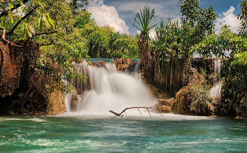
A small waterfall with silky flowing water cascading over light brown, textured limestone tufa rocks into a turquoise pool, surrounded by dense tropical foliage.
A small waterfall flowing over Tindall limestone tufa formations along the Flora River.

Giwining / Flora River Nature Park history and protected-area timeline

Giwining / Flora River Nature Park was formally established on 7 July 1993 as a protected area in the Northern Territory of Australia. Its declaration brought a substantial reach of the Flora River and its associated spring systems under coordinated state-level conservation management, while also recognizing the longstanding cultural connection of the Wardaman people to the area.

The park is now jointly overseen by the Parks and Wildlife Commission of the Northern Territory and the traditional owners, an arrangement that reflects the modern Northern Territory approach to protected-area governance. This shared stewardship has shaped both the visitor experience and the long-term management focus of the reserve, with traditional-owner input into planning, cultural interpretation, and on-ground care.

Since its establishment, Giwining has remained a relatively quiet nature park, primarily associated with barramundi fishing, short walks to waterfalls, and appreciation of the unusual tufa formations rather than large-scale tourism infrastructure. Its history is therefore less about dramatic events and more about the gradual development of a small but distinctive protected-area identity around a spring-fed tropical river.

Giwining / Flora River Nature Park landscape and geographic character

The landscape of Giwining / Flora River Nature Park is defined by water and rock. The park follows a 25 kilometre stretch of the Flora River, fed by a network of springs that emerge from the surrounding Tindall Limestone. Over long periods, the calcium-rich spring waters have deposited extensive tufa and travertine formations, building natural dams, terraced shelves, and shallow basins along the spring-fed creeks that join the main river.

In the wet season, heavy tropical rainfall swells the Flora River and its tributaries, turning the spring-fed creeks into cascading systems and reinforcing the park's dramatic waterfalls. Kathleen Falls and Djarrung Falls are among the most prominent seasonal features, each accessible by short walks and offering visitors a glimpse of the park's more rugged terrain. As the dry season settles in, water levels drop and the geology of the spring systems becomes more visible, exposing the tufa dams and the deep, still pools that collectors and fishers return to throughout the year.

Surrounding the river corridor, the landscape rises into savanna woodland typical of the Katherine region. Low limestone ridges, open woodland, and seasonal drainage flats create the broader setting for the park, framing the river as a clearly defined green corridor cutting through dry tropical country.

Giwining / Flora River Nature Park ecosystems, habitats, and plant life

Ecologically, Giwining / Flora River Nature Park is a riverine and spring-fed refuge within the broader Top End tropical savanna. The park's defining natural feature is the spring system itself: a series of permanent, groundwater-fed discharges that support lush fringing vegetation, aquatic plant communities, and stable freshwater conditions in an otherwise strongly seasonal landscape.

Along the riverbanks and spring margins, paperbark and other moisture-dependent species create narrow gallery forests that contrast with the surrounding eucalypt-dominated woodlands. These riparian and spring habitats are concentrated, ecologically productive zones within the park, supporting freshwater invertebrates, fish, waterbirds, and a wide range of dependent terrestrial species.

Within the larger woodland matrix, vegetation patterns reflect the transition from alluvial flats and seasonal drainage lines to the harder, rockier country associated with the Tindall Limestone. This mosaic creates a subtle but real ecological diversity, in which the constant presence of water along the central corridor supports a richer suite of species than the surrounding dry woodlands. The park's nature is therefore best understood not as a single ecosystem but as a graduated system in which river, springs, forest, and savanna interact.

Giwining / Flora River Nature Park wildlife and species highlights

Wildlife in Giwining / Flora River Nature Park is shaped by the contrast between the park's reliable freshwater habitats and the seasonally harsh surrounding savanna. The spring-fed pools and the slow stretches of the Flora River support populations of freshwater fish, including barramundi, which have made the park a long-standing destination for anglers in the Katherine region.

The river system also supports saltwater crocodiles, whose presence is the key reason swimming, wading beyond safe areas, and boating are not permitted within the park. Crocodile management is therefore a defining element of the visitor experience and of wildlife policy across the reserve.

Beyond the waterways, the park's mix of riparian forest and open tropical woodland supports typical Northern Territory birdlife, reptiles, and mammals associated with the Top End, including woodland birds that concentrate around water sources during the dry season. Mammals adapted to both riverine and savanna environments use the corridor of permanent water as a year-round refuge.

The combination of a relatively undisturbed river system, an unusual spring complex, and the surrounding savanna gives Giwining a distinctive wildlife profile in which aquatic species; large reptiles; and dry-country woodland fauna all converge in a compact reserve.

Giwining / Flora River Nature Park conservation status and protection priorities

From a conservation perspective, Giwining / Flora River Nature Park is significant because it protects a rare tropical spring complex, a substantial stretch of the Flora River, and the ecological gradient that links aquatic habitat, riparian forest, and tropical savanna. The tufa and travertine systems built by the springs are themselves the product of long-term geological processes, and the protected status of the reserve helps ensure that the water quality and hydrology that sustain them remain undisturbed.

The park also plays an important role in maintaining healthy populations of freshwater fish, including barramundi, in a region where riverine habitat is increasingly valued for both biodiversity and recreational fishing. By preventing large-scale development along the river corridor and restricting high-impact activities through crocodile-related safety rules, the protected area supports habitat values that extend beyond its own boundaries.

Joint management by the Northern Territory Government and the Wardaman traditional owners adds a cultural dimension to conservation at Giwining, recognizing that the country has been actively cared for long before formal protection and that ongoing management benefits from this continuity.

Giwining / Flora River Nature Park cultural meaning and human context

The cultural context of Giwining / Flora River Nature Park is inseparable from the Wardaman people, the traditional owners of the land on which the park sits. Their connection to the river, the springs, and the surrounding country long predates the park's 1993 establishment, and they continue to play an active role in how the area is governed and interpreted.

The park's naming reflects this heritage, with 'Giwining' sitting alongside the European-derived 'Flora River' to acknowledge both Indigenous and colonial naming traditions. Shared management between the Wardaman and the Parks and Wildlife Commission of the Northern Territory shapes decisions about visitor access, cultural protocols, and on-ground programs, reinforcing that the park is both a conservation reserve and a continuing cultural landscape.

While the park is not widely promoted as a tourism-focused cultural site, the Wardaman presence is a defining part of its identity and a key reason why Giwining differs from many other Northern Territory nature parks in structure and governance.

Top sights and standout views in Giwining / Flora River Nature Park

Giwining / Flora River Nature Park's strongest points of distinction are its spring-fed limestone system, the long reach of the Flora River it protects, and the unusually compact combination of tufa formations, seasonal waterfalls, and barramundi habitat within a single reserve.

Visitors are drawn to accessible features such as Kathleen Falls and Djarrung Falls, both reached by short walks, and to the broader experience of a quiet tropical river park set well away from the Northern Territory's main tourism corridors. Joint management with the Wardaman people adds cultural depth, and the park's emphasis on fishing and land-based sightseeing, rather than swimming or boating, defines a distinctive visitor character shaped by both safety considerations and the desire to keep this landscape relatively undisturbed.

Best time to visit Giwining / Flora River Nature Park

The character of a visit to Giwining / Flora River Nature Park changes notably with the seasons. During the Top End wet season, the Flora River and its tributaries swell with tropical rainfall, and the spring-fed creeks become more dynamic, intensifying the waterfalls and the surrounding greenery, though access can be affected by seasonal road conditions.

The dry season, generally from around May through September, brings more stable weather, easier road access, and clearer conditions for appreciating the park's geology. As water levels fall, the tufa dams and spring pools become more visible, barramundi fishing is typically a focus, and wildlife tends to concentrate around the remaining surface water. For visitors who prefer comfortable travel conditions, distinctive scenery, and good fishing, the dry months tend to offer the most rewarding experience.
Monthly climate preview

Long-term representative temperature and precipitation averages recorded across twelve months

Giwining / Flora River Nature Park Climate Normals and Annual Weather Patterns

Representative coordinate measurements reveal sustained high maximum temperatures alongside distinct wet and dry precipitation shifts throughout the year at Giwining / Flora River Nature Park. Examining the complete monthly climate dataset provides a comprehensive look at long-term temperature ranges and precipitation normals.
Annual mean27 °C
23 °C32 °C
Jan28°
Feb27°
Mar27°
Apr26°
May24°
Jun23°
Jul23°
Aug25°
Sep30°
Oct32°
Nov32°
Dec30°
Warmest month
October

32.1 °C

Coolest month
June

22.7 °C

Wettest month
January

8.7 mm/day

Driest month
July

0 mm/day

Park location guide

Geography guide, regional context, and park location map for Giwining / Flora River Nature Park

Giwining / Flora River Nature Park park geography, regions, and map view in Australia

Understand where Giwining / Flora River Nature Park sits in Australia through a broader geographic reading of the surrounding landscape, nearby location context, and its mapped position within the national park landscape.

How Giwining / Flora River Nature Park fits into Australia

Australia is a constitutional monarchy and federal parliamentary democracy comprising six states and ten territories. With a population of nearly 28 million, it is one of the world's most urbanised countries, with most people concentrated on the eastern seaboard. The country has a high Human Development Index and is known for its cultural diversity, ancient Aboriginal heritage, and unique wildlife.

Wider geography shaping Giwining / Flora River Nature Park in Australia

Australia occupies the entire Australian continent, the island of Tasmania, and numerous smaller islands. It is the world's flattest and driest inhabited continent, featuring vast deserts in the interior (the Outback), tropical rainforests along the eastern coast, and a coastline bordering the Indian and Pacific Oceans.

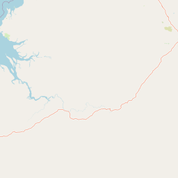
Map view of Giwining / Flora River Nature Park

Use this park location map to pinpoint Giwining / Flora River Nature Park in Australia, understand its exact geographic position, and read its mapped placement within the surrounding landscape more clearly.

Pigeon | © OpenStreetMap contributors

Location context for Giwining / Flora River Nature Park

Northern Territory

Visual reference of limestone springs, tufa formations, and tropical river habitats

Giwining / Flora River Nature Park Photos and Mapped Landscape Scenery

Captured imagery reveals the diverse terrain, spring-fed waterways, and distinct protected-area environment of Giwining / Flora River Nature Park. Visual documentation provides clear insight into the remote tropical savanna landscape and rare geological formations defining the region.

A small waterfall with silky flowing water cascading over light brown, textured limestone tufa rocks into a turquoise pool, surrounded by dense tropical foliage.

Park atlas

Compare regional savanna reserves and connected limestone landscapes across the Top End

Other Parks Near Giwining / Flora River Nature Park and Surrounding Protected Areas

Continue exploring protected natural areas by comparing adjacent regional parks and river reserves located near Giwining / Flora River Nature Park. Examining these surrounding habitats provides deeper geographic context into the tropical savanna ecosystems and limestone spring networks of the Northern Territory.
Protected landscapeNorthern Territory
About 69 km away#1 closest

Northeast

Kintore Caves Conservation Reserve: Karst Geography and Protected Landscape Analysis

Mapping subterranean terrain and cultural heritage in Australia's Northern Territory.

Kintore Caves Conservation Reserve in the Northern Territory is a vital protected area defined by its rare limestone karst geology and extensive cave networks. This site provides a concentrated look at subterranean biodiversity and archaeological history within a transitional rural setting near Katherine, showcasing the importance of focused conservation boundaries in safeguarding geological and human-linked landscapes.

Area
4.23 km²
Established
1965
IUCN
V
Access
Access unknown
National parkNorthern Territory
About 81 km away#2 closest

Northeast

Nitmiluk National Park: Detailed Protected Landscape and Geographic Context

Explore mapped park boundaries and regional terrain.

Delve into the specifics of Nitmiluk National Park, a designated national park within the Northern Territory of Australia. This section focuses on its protected-area status and how its geography contributes to the regional landscape. Users can explore the park's mapped extent and understand its placement within the broader geographical atlas, highlighting its importance as a distinct protected natural area.

Area
2,946.64 km²
Established
1977
IUCN
II
Visitors
309.8K annual
Watercolor illustration showing rolling green hills, a red rock formation, and scattered trees
National parkNorthern Territory
About 85 km away#3 closest

Southwest

Judbarra National Park: Northern Territory National Park Protected Landscape and Geography

Discover its mapped terrain and ancient Indigenous rock art.

Judbarra National Park is a major national park in Australia's Northern Territory, recognized for its extensive Indigenous rock art, which constitutes a significant artistic province. Spanning a vast area with two distinct geographic sections, the park showcases a transition between tropical and semi-arid ecosystems. Users can explore its rugged terrain, sandstone escarpments, and mapped park boundaries to understand its unique regional geographic context and rich cultural heritage.

Area
13,004.1 km²
Established
1990
IUCN
II
Relief
Mixed relief
Nature reserveNorthern Territory
About 94 km away#4 closest

East

Cutta Cutta Caves Nature Park: A Tropical Karst and Cave Reserve in Northern Territory

Protected tropical limestone karst and subterranean landscape geography.

Cutta Cutta Caves Nature Park is a specialized protected area in Australia, safeguarding a unique tropical limestone karst landscape near Katherine. This reserve manages subterranean cave systems, mineral-rich chambers, and the surrounding woodland terrain. As a significant ecological site, it provides essential habitat for rare wildlife, highlighting the complex intersection of geological formations and tropical biodiversity within the Northern Territory.

Area
14.99 km²
Established
1967
IUCN
III
Visitors
17.2K annual
National parkNorthern Territory
About 99 km away#5 closest

Northwest

Fish River Station National Park: Protected Landscapes and Geographic Atlas

Indigenous-managed conservation in the Northern Territory

Fish River Station serves as a critical conservation block south of Darwin, featuring a distinctive blend of riverine floodplains, billabongs, and rugged upland ranges. Its protected boundaries preserve a wide array of tropical habitats, highlighting the intersection of traditional land management and large-scale environmental preservation within the Australian National Reserve System.

Area
1,781 km²
Established
2010
IUCN
II
Relief
Mixed relief
National parkAustralia
About 131 km away#6 closest

Northeast

Kakadu National Park: Australia's Protected Landscape and Regional Geography

Explore Kakadu National Park's mapped boundaries and natural terrain.

Kakadu National Park stands as a significant national park entity within Australia, providing rich geographic context for atlas discovery. This page details the park's protected area identity, its mapped natural landscapes, and its place within the broader Australian continent's geography. Understand the unique regional setting and the specific topographic features that define Kakadu National Park for detailed exploration and comparative geographic analysis.

Area
19,804 km²
Established
1979
IUCN
II
Visitors
250K annual
National parkNorthern Territory
About 155 km away#7 closest

Northwest

Litchfield National Park: Northern Territory National Park Protected Landscape Atlas

Explore regional geography and mapped park boundaries.

Litchfield National Park is a protected natural area located in Australia's Northern Territory, designated as a national park. This page offers detailed geographic context and explores the park's mapped boundaries, providing a foundational understanding of its protected landscape identity. Discover how Litchfield National Park fits within the broader atlas of Australian conservation lands, highlighting its regional geographic significance and mapped terrain.

Area
1,458.47 km²
Established
1991
IUCN
II
Visitors
329.6K annual
National parkNorthern Territory
About 160 km away#8 closest

East

Elsey National Park: Northern Territory National Park Atlas and Protected Landscape Context

Discover the mapped terrain and unique natural features of Elsey National Park.

Elsey National Park, located in Australia's Northern Territory, is a significant protected area known for its distinctive thermal springs and characteristic paperbark woodlands. This national park provides a valuable point of study for understanding regional geography, mapped natural landscapes, and the hydrological importance of its riverine environments, offering a concrete example of protected land within the tropical savanna biome.

Area
138.96 km²
Established
1991
IUCN
II
Visitors
207.7K annual

Common questions about visiting, size, designation, and location context for Giwining / Flora River Nature Park

Giwining / Flora River Nature Park FAQs for park facts, access, geography, and protected area context

Find quick answers about Giwining / Flora River Nature Park, including protected-area facts, park geography, trail and visitor context, and how the park fits into its surrounding country and regional landscape.
MoriAtlas Explorer

Continue Your Protected Areas Search Across the Global Atlas

Deepen your exploration by continuing the structured search for national parks and protected areas worldwide. Utilize the comprehensive filtering capabilities to compare different conservation landscapes and refine your understanding of global park geography. Discover more about the distribution and characteristics of protected natural areas.

Global natural geography