
Mori Atlas logo
Nature reserveGlindower Alpen

A distinct post-industrial nature reserve featuring deep ravines and mixed forests

Glindower Alpen: Exploring the Protected Clay Mining Landscape and Geography in Brandenburg

(Naturschutzgebiet Glindower Alpen)

The Glindower Alpen serves as a remarkable protected area within the state of Brandenburg, Germany, where centuries of clay extraction for the regional brick industry have created a dramatic relief of ridges, slopes, and ravines. Situated near the Glindower See, this 120-hectare nature reserve stands in stark contrast to the surrounding flat plains and pine forests of the Mittelbrandenburgische Platten und Niederungen. The reserve features a dense mosaic of deciduous forests, dry grasslands, and small water bodies that provide valuable habitat diversity within a compact, post-industrial landscape.

nature reserveBrick-making landscapepost-industrial landscapeclay quarriesmixed deciduous forestdeadwood forest
A stylized flat-design illustration showing a sweeping valley view between large mountain cliffs, with a river and a waterfall in the background surrounded by dense pine forest.

Glindower Alpen

Nature reserve

Park overview

Structured park overview, official facts, and landscape profile for Glindower Alpen

Glindower Alpen park facts, protected area profile, and essential visitor context

Review the core facts for Glindower Alpen, including designation, size, terrain, visitor scale, habitats, and operating context in one park-focused overview.

About Glindower Alpen

The Glindower Alpen is a small nature reserve in Brandenburg that demonstrates how industrial heritage can become an ecological asset. Although its name suggests an Alpine character, the area is anything but mountainous in a regional sense. The 'Alpen' here refers to local spoil heaps or 'Erdeberge' (literally 'earth mountains') that were heaped up by clay miners over generations of brick production around Glindow. Once the clay pits became uneconomical, the same pits and mounds that made the area unappealing for conventional land use inadvertently created a terrain of unusually high relief within the Mittelbrandenburgische Platten und Niederungen.

This topographic variety translates directly into ecological variety. The ravines are deep and cool, harboring shade- and moisture-loving plant communities along their slopes; ridges and sun-exposed mounds support dry grassland; and the small ponds at the base of the ravines add still-water habitats. Mixed forests of sycamore and Norway maple, hornbeam, small-leaved lime, ash, beech, and black locust dominate much of the area. Because the forests are managed little or not at all for timber and deadwood is left in place, the woodland is rich in mosses, lichens, and structural complexity. The ponds are characterized by pondweed communities typical of small, sheltered waters.

Ecologically, the Glindower Alpen stands out sharply from the surrounding countryside, which is shaped by dry pine forests, large-scale fruit orchards, other farmland, and increasing settlement. The combination of its small size, sharp habitat contrast, and unusually varied relief in a flat region has made the reserve a well-known local destination for walking, school field trips, and informal nature study. Marked trails and interpretive panels introduce visitors to the geology, flora, and fauna of the post-clay-pit landscape.

Quick facts and research context for Glindower Alpen

Glindower Alpen is a designated Naturschutzgebiet in Brandenburg, located within Werder (Havel) in Landkreis Potsdam-Mittelmark. It lies southeast of Glindow and northwest of Petzow, just south of the Glindower See and west of the L 90 regional road. The reserve was formally placed under protection by ordinance on 30 June 1995 and carries the official designation number 1163. It covers about 119 to 120 hectares, making it a compact but highly varied protected site in the regional context of Brandenburg's natural areas.

Protection and recognition

Documented terrestrial protection scope and Natura 2000 records

Glindower Alpen Protection Status and International Recognition

Glindower Alpen maintains official terrestrial protection status backed by recorded Natura 2000 recognition sources. Structured atlas data compiles verified designation metrics and conservation boundaries for thorough geographical analysis.

International recognition

Protection details

Protection scope
Terrestrial
Transboundary protection
No
WDPA ID
163263
Park context

Deeper park guide and search-rich context for Glindower Alpen

Glindower Alpen history, landscape, wildlife, and travel context

Explore Glindower Alpen through its history, landscape character, ecosystems, wildlife, conservation priorities, cultural context, and seasonal travel timing in a structured park guide built for atlas discovery and search intent.

Why Glindower Alpen stands out

The reserve is especially known for the unusual, almost mountainous relief that resulted from centuries of clay extraction for the Brandenburg brick industry. Within a very small area, deep ravines up to around 40 meters, sheltered slopes, ridges, and small water bodies create a remarkable diversity of microhabitats, an uncommon geological and ecological feature in the otherwise flat Mittelbrandenburgische Platten und Niederungen. It is also notable for its largely unmanaged mixed deciduous forests dominated by sycamore maple, Norway maple, hornbeam, small-leaved lime, ash, beech, and black locust, abundant deadwood, moss- and lichen-covered surfaces, dry grassland fringes, and small ponds covered with pondweed. This compact mosaic of habitats, formed on former mining land, gives the Glindower Alpen their scientific and recreational interest.
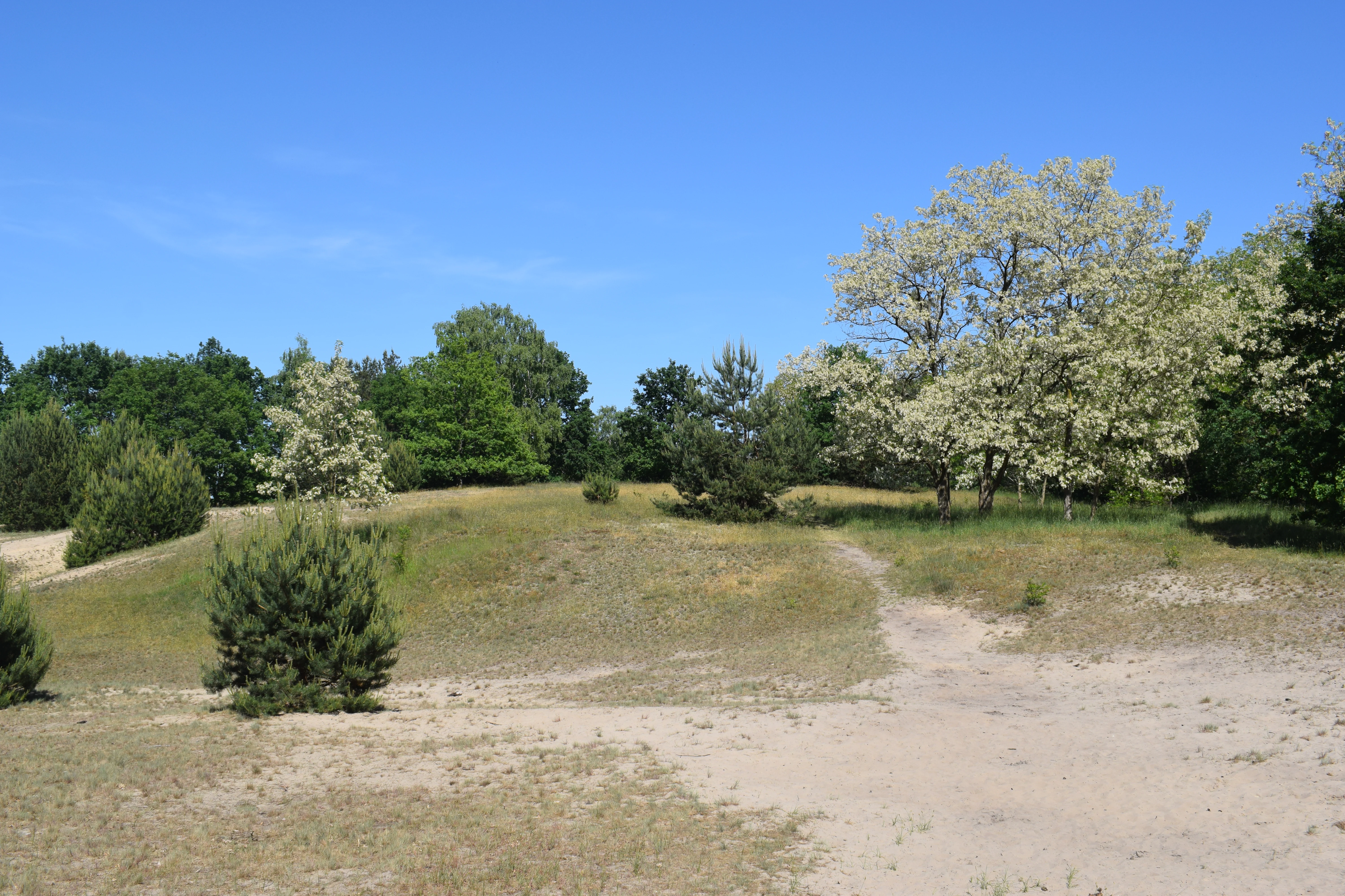
A sunny, sandy path winds through a hilly landscape with sparse grass, small shrubs, and blooming trees under a clear blue sky.
A sandy, sparsely vegetated plateau landscape in Glindower Alpen.

Glindower Alpen history and protected-area timeline

The Glindower Alpen is not a natural wilderness in origin, but a landscape shaped by the long history of brick manufacturing in the Mark Brandenburg. The area around Glindow was the site of clay mining (Tonabbau) for an Erdeberge clay works, and over the course of several centuries the cumulative effect of clay extraction left behind a network of pits, spoil heaps, and erosion channels.

This industrial past is what gives the present-day reserve both its name and its unusual character. By the second half of the twentieth century, the abandoned clay workings had produced a terrain whose deep ravines and mounds no longer fit the regional land-use pattern of dry pine woodlands and agricultural fields. Recognizing the resulting habitat diversity, the state of Brandenburg placed the area under formal protection as a Naturschutzgebiet by ordinance on 30 June 1995, under designation number 1163. A more recent regional study, Thomas Thränert's 2025 article 'Alpen aus Erdebergen. Die Umwertung und gestalterische Transformation der Bergbaufolgelandschaft Glindower Alpen' in Brandenburgische Denkmalpflege (Neue Folge, vol. 11, no. 2), has documented the cultural and landscape history of the site as a 'revaluation and creative transformation' of post-mining land.

Glindower Alpen landscape and geographic character

The most striking feature of the Glindower Alpen is its dramatic relief within an otherwise flat regional setting. The reserve lies within the Mittelbrandenburgische Platten und Niederungen, a broad landscape of low plateaus and shallow lowlands, yet within a few hectares it contains slopes and ravines up to roughly 40 meters deep. These landforms are not natural to the region, but are the eroded remnants of centuries of clay mining for the local brick industry, which left behind a labyrinth of pits and spoil heaps.

The result on the ground is a tight patchwork of ridges, sheltered slopes, valley bottoms, and small pond basins. Dry, sunny mound tops contrast sharply with cool, shaded ravines, while pockets of sandy substrate accumulate along slopes. The boundary of the area is defined by the villages of Glindow and Petzow, the regional L 90 road on the western edge, and the Glindower See to the north. Beyond the reserve, the surrounding landscape of dry pine woodland, fruit orchards, agricultural fields, and settlements makes the relief of the Glindower Alpen feel even more pronounced, almost like a miniature mountain range embedded in the Brandenburg plain.

Glindower Alpen ecosystems, habitats, and plant life

Ecologically, the Glindower Alpen represents an unusually compressed mosaic of habitats typical of a much larger and more varied region. The mix of ravines, slopes, dry ridges, and pond basins creates a strong gradient of moisture, light, and soil conditions that supports several distinct plant communities standing side by side.

The principal woodland type is mesophilic mixed forest. Species composition includes sycamore maple and Norway maple, hornbeam, small-leaved lime, ash, beech, and black locust. Because the forests have been little affected by forestry and deadwood is actively retained, the woodland structure is rich in fallen trunks, snags, and slow decay processes that support diverse mosses, lichens, and fungi. On the more sun-exposed parts of the site, particularly along the edges of the mounds and on sandy accumulations, dry grassland communities (Trockenrasen) take over, adding an open-land habitat type to the otherwise forested reserve.

At the bottom of the ravines, small standing waters have formed. These ponds are covered with floating pondweed (Teichlinsen), contributing a hygrophilic aquatic element to the habitat mosaic. The combination of cool and moist ravine forests, dry grassland fringes, deadwood-rich woodland, and standing water ponds is what makes this compact reserve ecologically distinctive in a regional context dominated by dry, coniferous woodlands.

Glindower Alpen wildlife and species highlights

Although the available sources do not provide a detailed species inventory, the Glindower Alpen is recognized locally for its rich fauna, which is supported by the unusually high habitat diversity within a small area. The combination of structured deadwood-rich mixed forest, dry open grasslands, deep cool ravines, and small ponds creates conditions for a wide range of insect, amphibian, bird, and small mammal life.

The standing waters at the base of the ravines, together with the conservation-oriented management that retains deadwood and avoids intensive forestry, contribute to habitat for amphibians and aquatic invertebrates, while the dry grassland edges and exposed slopes provide additional insect and reptile habitat. Interpretive panels along the visitor trails specifically highlight the area's flora and fauna, indicating that local authorities and conservationists treat the site as a notable hotspot for wildlife observation and ecological education in the Havel region. Precise species lists were not detailed in the source material, however, so specific claims about individual species are not made here.

Glindower Alpen conservation status and protection priorities

From a conservation perspective, the Glindower Alpen is important primarily as an example of how a relict industrial landscape can support a high level of biodiversity within an intensively used agricultural and settled region. Its designation as a Naturschutzgebiet under Brandenburg ordinance of 30 June 1995 (designation number 1163) reflects recognition that the former clay-mining terrain, with its ravines, slopes, and small water bodies, harbors ecological values that are rare in the Mittelbrandenburgische Platten und Niederungen.

The reserve's conservation value lies especially in its deadwood-rich, largely unmanaged mixed deciduous forest, its dry grassland fringes on spoil-heap soils, and its network of small ponds. Retaining deadwood and limiting forestry intensity are stated management features of the area, both of which are consistent with broader European conservation priorities for structurally rich woodland and post-mining habitats. The reserve is also listed among the protected areas of Landkreis Potsdam-Mittelmark and is referenced in the list of FFH (Habitat Directive) sites in Brandenburg, indicating its integration into wider regional and European conservation frameworks.

Glindower Alpen cultural meaning and human context

The cultural dimension of the Glindower Alpen is inseparably tied to the industrial heritage of the Glindow brick-making region. The very name 'Alpen' reflects local colloquial usage for the artificial 'mountains' of waste clay and rocky material that miners produced in pursuit of clay for brick (Ziegel) manufacture. This kind of clay mining was characteristic of the Mark Brandenburg, and over many generations it transformed a flat agricultural hinterland into a locally rugged terrain.

The modern reserve is therefore a place where industrial past and ecological present meet. Interpretive panels along the visitor trails explain the flora and fauna of the area, framing it as an educational site that connects natural history to the cultural and economic history of the region. Scholarly interest in this layered identity is reflected in recent publications such as Thomas Thränert's 2025 article on the 'revaluation and creative transformation' of the Glindower Alpen post-mining landscape in Brandenburgische Denkmalpflege.

Top sights and standout views in Glindower Alpen

A compact nature reserve with topography unlike anything else in its region, the Glindower Alpen packs deep clay-mining ravines, dry grassland ridges, deadwood-rich mixed forest, and shelly ponds into a footprint of roughly 120 hectares. The site is particularly striking for its contrast with the surrounding flat pine forests, orchards, and farmland, and for the way centuries of brick industry have inadvertently produced an island of habitat diversity that now anchors local conservation and outdoor recreation.

Best time to visit Glindower Alpen

Because the Glindower Alpen is a low-lying forest reserve with shaded ravines and small standing waters, the most comfortable conditions for walking are generally found in the milder half of the year. Spring and early summer bring fresh green foliage in the mixed deciduous canopy and active pond vegetation, while the exposed dry grassland slopes and warm edges can feel quite hot in midsummer. Autumn offers colorful leaf display in the maples, beeches, and limes and typically stable walking conditions.

Winter visits are possible on the marked trails, when the bare canopy reveals the dramatic relief of the ravines particularly clearly, but paths can be wet, slippery, or icy in the deeper valleys. For wildlife observation, late spring and early summer are commonly productive, while the structured deadwood-rich forest sustains fungi, mosses, and lichens year-round. Specific access, weather, or operational details were not provided in the source material.

Monthly climate preview

Long term temperature and precipitation records across twelve measured months

Glindower Alpen Climate Normals, Average Temperature and Precipitation

Glindower Alpen records a measured annual temperature range from sub-zero winter minimums to warm summer maximums alongside consistent daily precipitation. Reviewing the complete monthly climate normals clarifies the long-term meteorological rhythm sampled at representative park coordinates.
Annual mean9 °C
-1 °C20 °C
Jan-1°
Feb
Mar
Apr
May14°
Jun18°
Jul20°
Aug20°
Sep15°
Oct
Nov
Dec
Warmest month
July

20.3 °C

Coolest month
January

-0.7 °C

Wettest month
July

2.4 mm/day

Driest month
April

1 mm/day

Park location guide

Geography guide, regional context, and park location map for Glindower Alpen

Glindower Alpen park geography, regions, and map view in Germany

Understand where Glindower Alpen sits in Germany through a broader geographic reading of the surrounding landscape, nearby location context, and its mapped position within the national park landscape.

How Glindower Alpen fits into Germany

Germany is a federal republic in Western and Central Europe with a population of over 83 million across sixteen constituent states. It is Europe's largest economy by nominal GDP and a major global exporter and importer. The capital is Berlin, and the country borders Denmark, Poland, Czech Republic, Austria, Switzerland, France, Luxembourg, Belgium, and the Netherlands.

Wider geography shaping Glindower Alpen in Germany

Germany is located in Western and Central Europe, spanning 357,022 km². It borders Denmark to the north, Poland and the Czech Republic to the east, Austria and Switzerland to the south, and France, Luxembourg, Belgium, and the Netherlands to the west. The country has coastlines on the Baltic Sea and North Sea to the north, with the Alps located in the southern region.

Map view of Glindower Alpen

Use this park location map to pinpoint Glindower Alpen in Germany, understand its exact geographic position, and read its mapped placement within the surrounding landscape more clearly.

Pigeon | © OpenStreetMap contributors

Location context for Glindower Alpen

Brandenburg

Examine the dramatic topography, mixed deciduous forests, and clay extraction relief.

Glindower Alpen Photos and Landscape Scenery: Visualizing the Protected Terrain

Visual records reveal the striking contrast between deep excavated ravines and the flat Brandenburg plains surrounding the protected reserve. Photographic documentation highlights the unique post industrial microhabitats and forest ecosystems preserved within the terrain.

A sunny, sandy path winds through a hilly landscape with sparse grass, small shrubs, and blooming trees under a clear blue sky.

A dense, deciduous forest scene with bare trees, fallen logs, and leaf litter on a sloped, uneven ground surface.

Park atlas

Compare surrounding regional landscapes and connected conservation zones

Explore Protected Areas and Parks Near Glindower Alpen

Browse other protected areas and nature reserves located near Glindower Alpen across the Brandenburg plain. Comparing these neighboring conservation landscapes provides broader context on local topography, post-industrial terrain, and regional biodiversity.
Nature reserveBrandenburg
About 7.6 km away#1 closest

Northwest

Naturschutzgebiet Krielower See: Protected Nature Reserve and Glacial Wetland Geography

Located in Brandenburg, this reserve protects a complex, silted-up lake basin and wetland network.

Naturschutzgebiet Krielower See protects a distinct glacial landscape near the Havel river. This 155-hectare nature reserve preserves a network of alder carr, reed beds, and wet meadows, providing an essential refuge for diverse species within the broader Havelland natural region. Explore the mapped topography and conservation context of this integral Brandenburg wetland habitat.

Area
1.55 km²
Established
2004
Relief
Lowland
Climate
Temperate
A watercolor illustration showing a landscape with small clusters of trees and grassy ground under a soft, light-filled sky.
Nature reserveBrandenburg
8.1 km away#2 closest

Southwest

Lehniner Mittelheide und Quellgebiet der Emster: Nature Reserve and Protected Landscape Atlas

Mapping Brandenburg inland heath and spring valley terrain

Examine the geographic layout of Lehniner Mittelheide und Quellgebiet der Emster, a nature reserve in the Brandenburg district of Potsdam-Mittelmark. This protected area connects dry sandy heathland with the aquatic corridors of the Emster headwaters and Mühlenteich pond, offering a clear example of glacial lowland landscape integration.

Area
6.4 km²
Established
1996
IUCN
IV
Relief
Lowland
Watercolor painting of a lush, flat landscape with low green hills in the distance and wetland vegetation in the foreground.
Protected landscapeBrandenburg
About 14 km away#3 closest

Northwest

Landschaftsschutzgebiet Brandenburger Osthavelniederung: Protected Landscape and Regional Geography

Mapped Havel River floodplain and glacial moraine terrain in Brandenburg.

Covering over 9,000 hectares, this protected landscape serves as a prime example of the Brandenburg Havel region. The area integrates a network of canals, dikes, and backwater lakes with isolated moraine ridges, creating a diverse geographic mosaic of river-managed lowlands and forested glacial remnants.

Area
93.81 km²
Established
1998
Relief
Lowland
Climate
Temperate
A soft watercolor painting showing rolling green hills, patches of open land, and trees against a pale sky background.
Nature reserveHavelland
15 km away#4 closest

Northeast

Döberitzer Heide Nature Reserve: Geographic Atlas and Protected Landscape Mapping

Glacial sand flats and heathlands in the Havelland region

Döberitzer Heide occupies a unique position on the southeastern Nauener Platte, providing a study of dry heath, grassland, and wetland habitats. Once a restricted military training ground, the area now functions as a vital protected landscape where European bison and wild horses maintain open terrains. This atlas entry focuses on the regional geography and the structural components of this nature reserve situated near the urban centers of Berlin and Potsdam.

Area
34.15 km²
Established
1997
Relief
Upland
Climate
Temperate
A horizontal watercolor illustration depicting a calm lake surrounded by soft green forest and distant hazy hills.
Protected areaBerlin
About 15 km away#5 closest

Northeast

EU-Vogelschutzgebiet Westlicher Düppeler Forst: Protected Area and Regional Geography

Ecological sanctuary and Havel lakeshore landscape in Berlin

Located in the Steglitz-Zehlendorf district, this protected area spans nearly 10 square kilometres of diverse woodland and aquatic terrain. The site combines historical cultural landmarks with essential breeding grounds for migratory birds, including significant woodpecker populations and varied riparian corridors throughout the southwestern Berlin borderlands.

Area
9.44 km²
Established
2003
A soft watercolor illustration of a rolling green landscape with a small cluster of trees and birch trees in the foreground, against a pale background.
Nature reserveBrandenburg
16 km away#6 closest

North

Ferbitzer Bruch Nature Reserve: Exploring Brandenburg Protected Landscape Boundaries

A lowland mosaic of sandy habitat in the Havelland region

Ferbitzer Bruch provides a focused look at the sandy lowland ecosystems characteristic of western Brandenburg. This nature reserve, anchored between the Havel Canal and the Döberitzer Heide, preserves a distinct mosaic of open heath, scrub, and woodland habitats that define this segment of the German landscape.

Area
11.564 km²
Established
1996
IUCN
IV
Watercolor painting of a green wetland area with soft, blurred rolling hills in the background.
Nature reserveBerlin
About 16 km away#7 closest

East

Großes Fenn Nature Reserve: Protected Peatland and Kettle Bog Geography in Berlin

A study of post-glacial landforms and mire environments.

Großes Fenn represents a rare urban kettle bog formed during the last glacial period, now protected within the Berlin region. This reserve showcases the historical peat-forming processes and the fragile ecological balance of small depressions in the Düppeler Forest, offering a compact site for understanding glacial landscape legacies.

Area
0.064 km²
Established
1986
IUCN
IV
A soft, artistic watercolor painting of a river landscape with trees, grassy banks, and rolling hills in the background.
Nature reserveBrandenburg
About 16 km away#8 closest

North

Falkenrehder Wublitz Nature Reserve: Brandenburg Wetland Geography and Protected Landscape Atlas

A mapped riparian wetland reserve within the Havel valley floodplain.

Falkenrehder Wublitz is a nature reserve in Brandenburg, Germany, established to safeguard a representative slice of the Havel lowland wetlands. Centered on the Wublitz side arm of the Havel river, this protected area features diverse aquatic habitats, wet meadows, and swamp forests. The reserve plays a functional role in regional conservation by linking smaller wetland pockets into a broader, connected riparian landscape near the Havel Canal.

Area
0.976 km²
Established
2002
IUCN
IV

Common questions about visiting, size, designation, and location context for Glindower Alpen

Glindower Alpen FAQs for park facts, access, geography, and protected area context

Find quick answers about Glindower Alpen, including protected-area facts, park geography, trail and visitor context, and how the park fits into its surrounding country and regional landscape.
MoriAtlas Explorer

Continue Your Protected Areas Search Across the Global Atlas

Deepen your exploration by continuing the structured search for national parks and protected areas worldwide. Utilize the comprehensive filtering capabilities to compare different conservation landscapes and refine your understanding of global park geography. Discover more about the distribution and characteristics of protected natural areas.

Global natural geography