
Mori Atlas logo
Nature reserveGlockenbuckel von Viernheim

Geographic overview of inland sand dunes and dry grassland habitat conservation

Glockenbuckel von Viernheim Nature Reserve: Mapped Protected Landscapes in Hessen

(Naturschutzgebiet Glockenbuckel von Viernheim)

Glockenbuckel von Viernheim represents a critical protected area in the Hessian Upper Rhine plain, defined by rare inland sand dunes and dry grassland ecosystems. This nature reserve serves as an essential biodiversity hotspot for specialist flora and fauna, illustrating a unique evolution from former military land to a protected ecological refuge. The site offers significant value for understanding regional geomorphology and the active management of fragile sandy habitats within a busy metropolitan landscape.

inland dunesdry sandy grasslandsand biotopepine standsUpper Rhine PlainHessian nature reserve
A stylized graphic illustration of a mountain valley, featuring a tall waterfall dropping into a winding river surrounded by evergreen trees under a bright sun.

Glockenbuckel von Viernheim

Nature reserve

Park overview

Structured park overview, official facts, and landscape profile for Glockenbuckel von Viernheim

Glockenbuckel von Viernheim park facts, protected area profile, and essential visitor context

Review the core facts for Glockenbuckel von Viernheim, including designation, size, terrain, visitor scale, habitats, and operating context in one park-focused overview.

About Glockenbuckel von Viernheim

Glockenbuckel von Viernheim is a compact Hessian nature reserve centered on a strip of inland sand dunes on the Upper Rhine Plain just west of the Viernheim built-up area. The protected area covers roughly 40 hectares and consists of two rectangular patches of open sandy grassland set corner to corner, embedded inside a larger pine and mixed forest landscape. Although the surrounding area is now heavily wooded, the reserve itself is deliberately kept open, gently undulating, and almost bare, so that the dune soils and their specialized life forms remain visible and viable.

The reserve's setting in the Hessisches Ried, between Viernheim and the Mannheim metropolitan area, places it at the inland end of a long dune belt that runs from northern Baden through the Darmstadt region along the Rhine plain. These dunes were built up by windblown sand during the closing phase of the last ice age, around ten thousand years ago, and have shifted between open and forested conditions many times since. What distinguishes the Glockenbuckel from most other dunes in this belt is its current openness and its unusually high diversity of rare, sand-adapted species, which is directly linked to its more recent military past.

The site is layered into multiple protection systems. The Hessian nature reserve designation came first in February 1998, under a regulation issued by the Darmstadt regional council. A nearly identical area was then confirmed as an FFH (Fauna-Flora-Habitat) site under the EU Habitats Directive, and that area in turn sits inside a larger EU special protection area for birds covering forests of the southern Hessian Upper Rhine plain. The reserve is also part of the Geo-Naturpark Bergstrasse-Odenwald. In 2007 it was selected as Geotope of the Year within that park, recognizing both the geological interest of the dune belt and the conservation importance of the site.

For visitors, the landscape offers something rare in this densely populated corner of Germany: a piece of open, sandy, heath-like terrain that still feels semi-natural even though its modern character was created by human activity. Its closeness to Viernheim, to the autobahn, and to Mannheim makes the reserve both a quick escape from the city and a conservation challenge, since trampling, dogs, litter, campfires, and uncontrolled access can quickly damage the fragile sandy soils. Active management by professional and volunteer conservationists is therefore central to keeping the site from simply reverting to pine forest.

Quick facts and research context for Glockenbuckel von Viernheim

Glockenbuckel von Viernheim is a nature reserve (Naturschutzgebiet) on the Upper Rhine Plain in Viernheim, Hesse, within the Landkreis Bergstrasse. It covers about 40 hectares of inland sand dunes, dry sandy grassland, and pine stands set inside a much larger forested area west of the A6 motorway. It was designated as a nature reserve on 4 February 1998 and is almost fully coincident with the EU Natura 2000 Habitat Directive site DE6417305, and falls within the EU bird protection area covering forests of the southern Hessian Upper Rhine plain. The open sand surface is widely known locally as the Viernheimer Heide and serves both as a protected habitat and as a popular nearby recreation area for residents of Viernheim and the Mannheim urban region. The site is part of the Geo-Naturpark Bergstrasse-Odenwald and was named Geotope of the Year in 2007.

Protection and recognition

Documented conservation records and management framework details

Glockenbuckel von Viernheim Protection Status and Official Designation Data

Glockenbuckel von Viernheim brings together verified protection status records and designation details within the global database. Official administrative context and recognized parameters provide complete clarity for this protected area.

Protection details

WDPA ID
318444
Park context

Deeper park guide and search-rich context for Glockenbuckel von Viernheim

Glockenbuckel von Viernheim history, landscape, wildlife, and travel context

Explore Glockenbuckel von Viernheim through its history, landscape character, ecosystems, wildlife, conservation priorities, cultural context, and seasonal travel timing in a structured park guide built for atlas discovery and search intent.

Why Glockenbuckel von Viernheim stands out

Glockenbuckel is best known as one of the most important inland sand and dry grassland reserves in Hesse, with a remarkable concentration of rare, heat-loving flora and fauna. Inland dunes formed from windblown sand at the end of the last ice age here support silver grass and blue Schiller grass swards, sparse sand thyme, sand immortelle, and steppe spurge on near-sterile sandy soils, fringed by scattered pine. Because the open sandy substrate and rapidly changing soil temperatures were created and maintained by tank manoeuvres after 1945, the reserve is also famous as a textbook example of how former military training ground can become a biodiversity hotspot. Ecologically it stands out for spiders, ground beetles, wild bees, solitary wasps, sand-loving grasshoppers, ground-nesting birds such as the wood lark and nightjar, and rare reptiles and amphibians such as the sand lizard and natterjack toad. It combines strict conservation protection with intensive public use, making it a notable example of habitat management in a peri-urban setting.
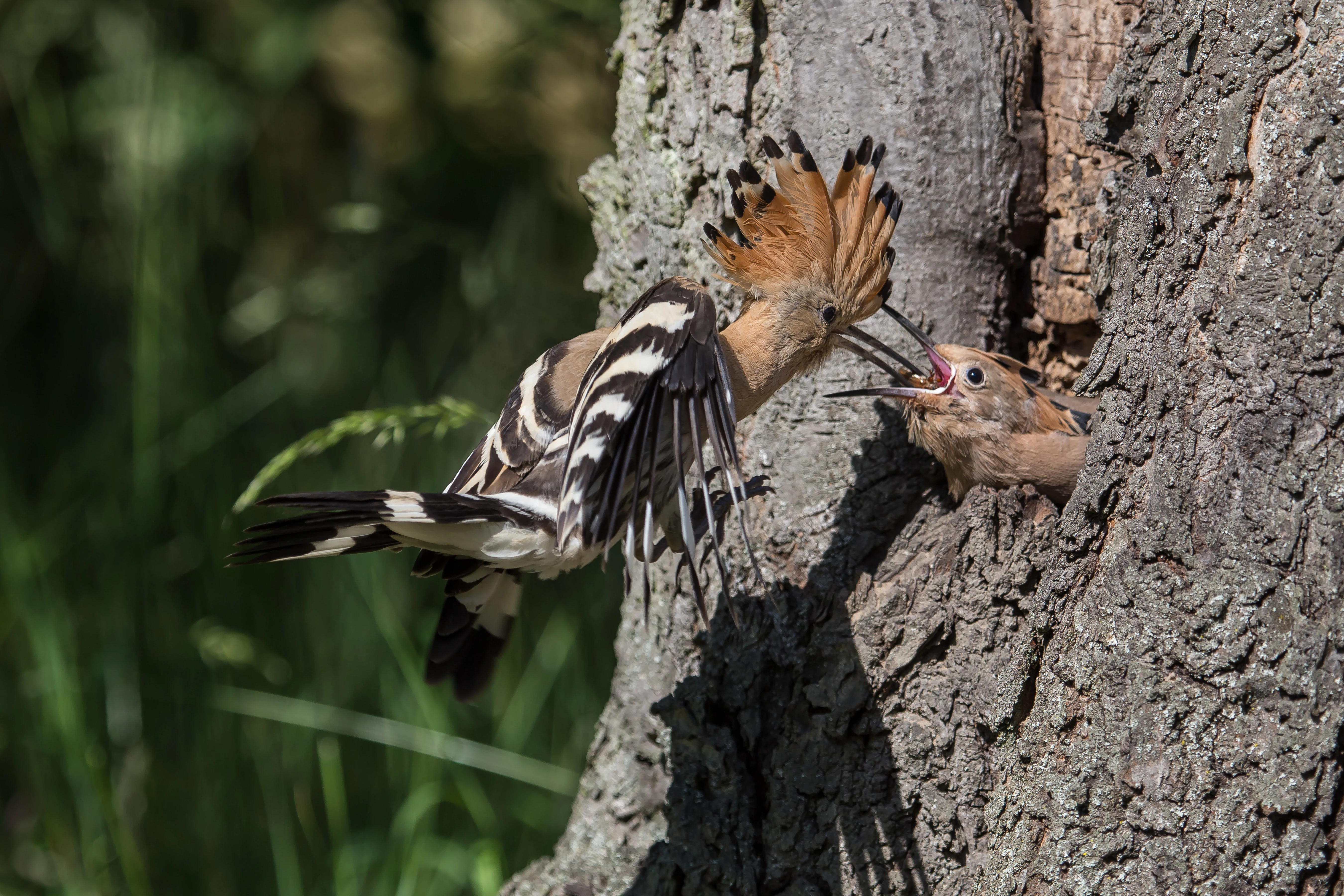
A hoopoe bird with a distinctive crest and black and white striped wings feeds a small chick poking its head out of a hole in a tree trunk.
A hoopoe feeding its chick at a nesting cavity within the Glockenbuckel von Viernheim nature reserve.

Glockenbuckel von Viernheim history and protected-area timeline

The dunes on which the Glockenbuckel reserve sits were formed at the end of the last ice age, roughly ten thousand years ago, when windblown sand accumulated across the Rhine plain in a long belt running from northern Baden into the Darmstadt region. For thousands of years after that the landscape alternated between open sandy grassland and pine forest, depending on land use and natural processes. By the twentieth century the Glockenbuckel area was again a piece of woodland, integrated into the larger forested Hessian Ried.

The decisive modern chapter began after the Second World War. From 1945 until 1994 the area was used as a tank training ground by US forces stationed near Viernheim. Tracked vehicles repeatedly stripped the soil, removed tree cover, displaced and mixed the sandy substrate, and generated the dry, warm, nutrient-poor conditions with strongly fluctuating soil temperatures that sand specialist species need. As soon as the tanks left, natural succession began to reclaim the site, and within a few years bushes and pines were starting to close in again.

Recognizing the unusual ecological value of the churned sand plain, the Darmstadt regional council (Regierungsprasidium Darmstadt) issued the protection order for the Viernheim inland sand biotopes on 4 February 1998, creating the Naturschutzgebiet Glockenbuckel von Viernheim with an area of about 40.8 hectares. Almost simultaneously the area was designated as an FFH site under the EU Habitats Directive, and later absorbed into a larger EU bird protection area for the southern Hessian Upper Rhine forests. In 2007 the reserve was named Geotope of the Year within the Geo-Naturpark Bergstrasse-Odenwald, recognizing its dual geological and ecological significance.

Because the original military disturbance no longer keeps the sand open, an active management regime was introduced essentially from the moment of designation. Conservation staff and volunteers remove invasive shrubs, graze the area with sheep, goats, and donkeys, mechanically expose sand patches from time to time to allow pioneer plants to re-establish, and manage the older pine stands to encourage dead wood and tree cavities. This ongoing intervention is what keeps the post-military landscape functioning as a biodiversity hotspot rather than collapsing back into ordinary forest.

Glockenbuckel von Viernheim landscape and geographic character

The reserve occupies a gently rolling section of the Hessian Upper Rhine plain, with low dune ridges, shallow sandy bowls, and small open flats threaded through surrounding pine forest. Two rectangular patches of open sand grassland, joined corner to corner, form the core of the protected area, together with the adjacent scattered pine groups. The total scene reads as a small patch of inland heath embedded inside continuous woodland. The most prominent named feature in the wider landscape is the Glockenbuckel hill itself, which rises to about 111 meters but actually sits just outside the boundary of the strict reserve rather than within it.

Soils across the area are almost entirely sandy, formed from windblown deposits at the close of the last ice age. Surface temperatures change rapidly because the loose, low-organic sand heats and cools quickly, and the substrate is nutrient-poor and free-draining. A tank track that runs along the edge of the reserve and through the junction of the two open rectangles is part of the post-war military imprint on the landscape and lies outside the formally protected area, but it illustrates how deeply the dune topography has been reworked by human activity.

A close up profile view of a natterjack toad sitting partially in shallow water against a blurred, golden-toned background.
A natterjack toad sitting in shallow water, a species native to the sandy habitats of Glockenbuckel von Viernheim.

Glockenbuckel von Viernheim ecosystems, habitats, and plant life

Ecologically, the Glockenbuckel reserve is shaped almost entirely by its dry, sandy, nutrient-poor substrate and by the active management that keeps it open. The vegetation mosaic includes silver grass swards and blue Schiller grass swards characteristic of inland dunes, interspersed with patches dominated by silver broom, scattered pine groups, and an unusually thin cover of higher plants. Where shrubs would normally invade, conservationists keep the canopy nearly absent to maintain the pioneer character of the site.

Several specialist plant species mark the dune grassland, including steppe spurge, sand thyme with its violet flowers, sand immortelle, and various drought-adapted grasses. Old pine stands on and around the reserve provide a different habitat layer, with cavities, dead wood, and bark features that other parts of the dune area cannot offer. The combination of warm bare sand, dry grassland, and old pines creates a stacked habitat structure, with bare ground pioneer zones on one side and mature pine communities on the other, separated by only short distances.

The reserve is formally recognized under the EU Habitats Directive for two priority and qualifying habitat types: inland dunes with open Corynephorus and Agrostis grasslands (EU code 2330) and dry, calcareous sand grasslands (EU code 6120). The latter is treated as a priority habitat type under EU rules, with stricter protection requirements. Conservation objectives are therefore defined not just by species lists but by the long-term persistence of these specific dune and dry-grassland habitat structures.

A close-up view of a blue-winged grasshopper in mid-air with wings spread, showing clear blue hindwings with dark edges against a blurred background.
A blue-winged grasshopper in flight, displaying its bright blue hindwings.

Glockenbuckel von Viernheim wildlife and species highlights

The fauna of the Glockenbuckel is what gives the reserve its broader reputation, and from an ecological standpoint it is regarded as the most important sandy dry area in all of Hesse because of the sheer density of Red List species. Specialists document more than 500 beetle species, around 190 spider species, and roughly 156 bee and wasp species across the reserve, many of them classified as threatened. Among the regularly highlighted insects are sand tiger beetles, the green coastal locust, the Italian beautiful locust, the wasp spider, and the blue-winged locust, all of which depend on warm bare sand and dry grasses.

For birds, the open sandy areas and old pines create conditions for a striking group of ground-nesting and insectivorous species. The wood lark sings from elevated song posts above the sand, the wryneck feeds on abundant ants in the pine stands, and the nightjar hides in low shrub cover by day and emerges at night to hunt insects over the dunes. The tawny pipit, the hoopoe, and other warmth-loving species have also been recorded in the area, and management plans under the EU Birds Directive specifically target these species.

Reptiles and amphibians are well represented despite the dry setting. Sand lizards bask in sunny patches, and the strongly threatened natterjack toad manages to breed here by using shallow, quickly warming puddles for its larvae. Solitary ground-nesting bees and wasps, sand wasps, and various spider species round out an invertebrate community that depends on the combination of bare sand, dry grass, and old wood for nesting, hunting, and shelter.
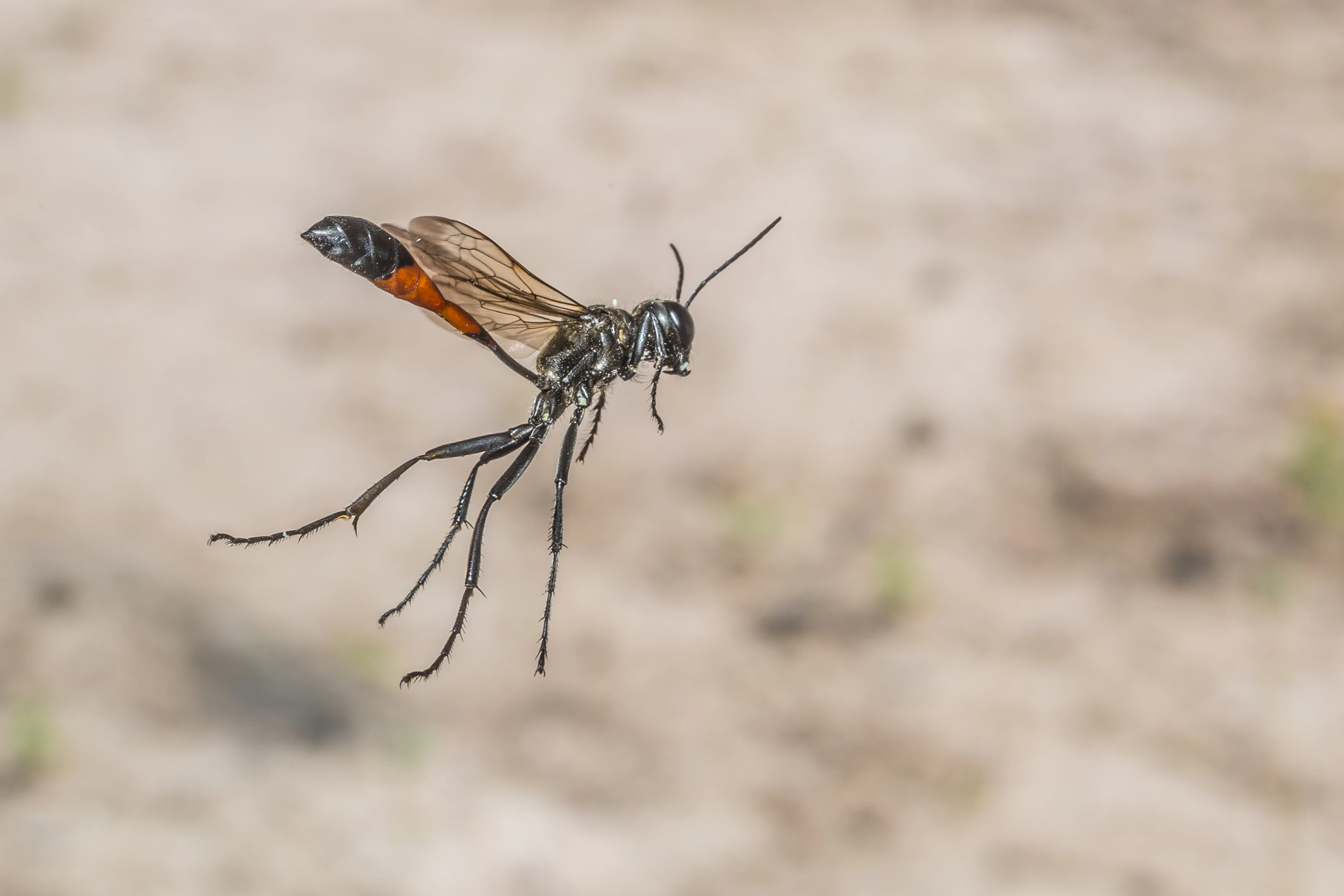
A close up view of a Great Golden Digger Wasp with black and orange coloration captured in mid air against a blurred sandy background.
A Great Golden Digger Wasp in flight, an insect species found in the sandy habitats of Glockenbuckel von Viernheim.

Glockenbuckel von Viernheim conservation status and protection priorities

Glockenbuckel is treated as a high-priority conservation site because it combines a rare and threatened habitat type, an exceptionally high density of Red List species, and a layered set of legal protections. The Hessian nature reserve designation runs in parallel with an almost identical EU Habitats Directive site and a wider EU bird protection area, all administered with input from the upper nature conservation authority at the Regierungsprasidium Darmstadt and within the framework of the Geo-Naturpark Bergstrasse-Odenwald. The 2007 Geotope of the Year recognition reflects both the geological value of the dune belt and the ecological significance of the protected area.

Conservation goals focus on keeping two specific habitat types viable over the long term: inland dunes with Corynephorus and Agrostis grasslands and dry, calcareous sand grasslands, the latter being a priority habitat under EU law. Because succession would otherwise close the open sand, management is treated as an essential conservation tool rather than an optional extra. Volunteer and professional conservationists remove non-native shrubs such as late-flowering cherry, black locust, and tree of heaven, while sheep, goats, and donkeys graze the area to keep the sward short. Mechanically scraped sand patches are periodically reopened to give pioneer plant species room to re-establish.

Target species drive much of this work. Management plans explicitly aim to maintain habitat for the green coastal locust and the natterjack toad as indicator and target species, support nightjar populations under the EU Birds Directive, and protect species listed in Annex II of the EU Habitats Directive. In the older pine stands, conservationists actively increase the amount of dead wood and the number of tree cavities to support nesting birds and saproxylic insects. The reserve is therefore not just a passively protected space but a managed conservation landscape in which habitat structure is intentionally maintained against both ecological succession and visitor pressure.

Glockenbuckel von Viernheim cultural meaning and human context

The open sandy area inside the reserve is locally known as the Viernheimer Heide and serves as an important nearby escape for residents of Viernheim and the Mannheim metropolitan area, who come to the site for walking, recreation, and a sense of open space that contrasts with the surrounding dense settlements. The modern shape of this landscape is itself part of post-war German cultural and military history, since the dunes were kept bare for decades by US forces training with tanks at Viernheim. When that military use ended in 1994, the area transitioned from a military training ground into a protected nature reserve within just a few years, a transition reflected in local awareness and in the conflicts that arise today between conservation goals and recreational use, including litter, free-running dogs, illegal camping, and campfires.
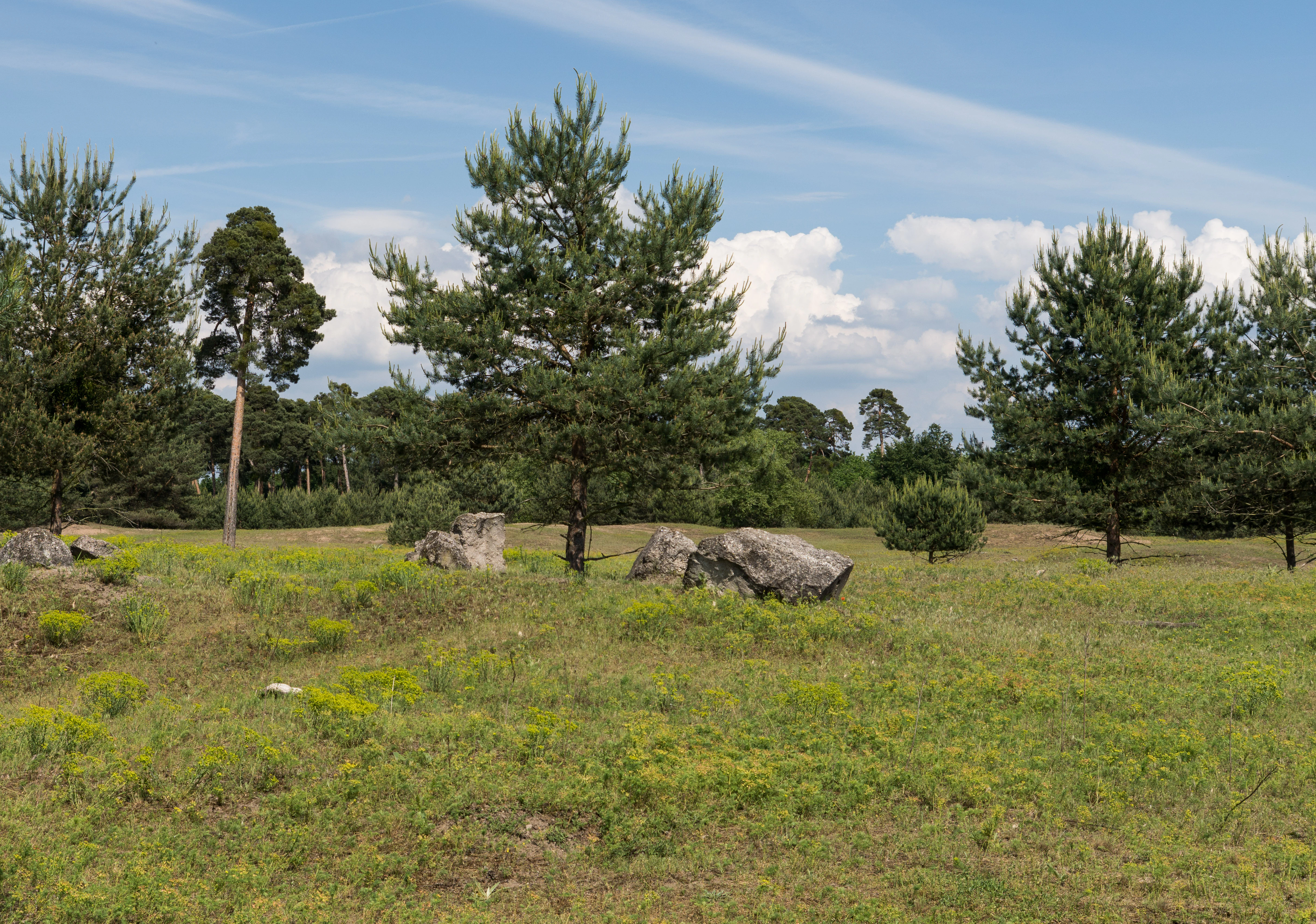
A sunny, open landscape with sparse, scrubby pine trees scattered across a grassy, sandy field, with large grey boulders visible in the midground.
A view of the sandy, dry grassland habitat at Glockenbuckel von Viernheim, characterized by sparse pine trees and rocky outcrops.

Top sights and standout views in Glockenbuckel von Viernheim

The reserve's strongest points of distinction are its inland dune character, its unusually high concentration of Red List species, and its ongoing open-land management. It is one of Hesse's most important sandy dry habitats, designated under both German nature reserve law and EU Natura 2000 instruments, and recognized as Geotope of the Year in 2007. Highlights to experience and understand include the silver grass and blue Schiller grass swards on the open dunes, the scattered pine groups on the fringe of the sand, the rare specialist plants such as steppe spurge, sand thyme, and sand immortelle, and the chance to be in habitat for wood lark, nightjar, wryneck, sand lizard, and natterjack toad. The site also stands out as a striking example of how a former tank training ground turned into a flagship conservation area managed in the middle of a busy urban region.
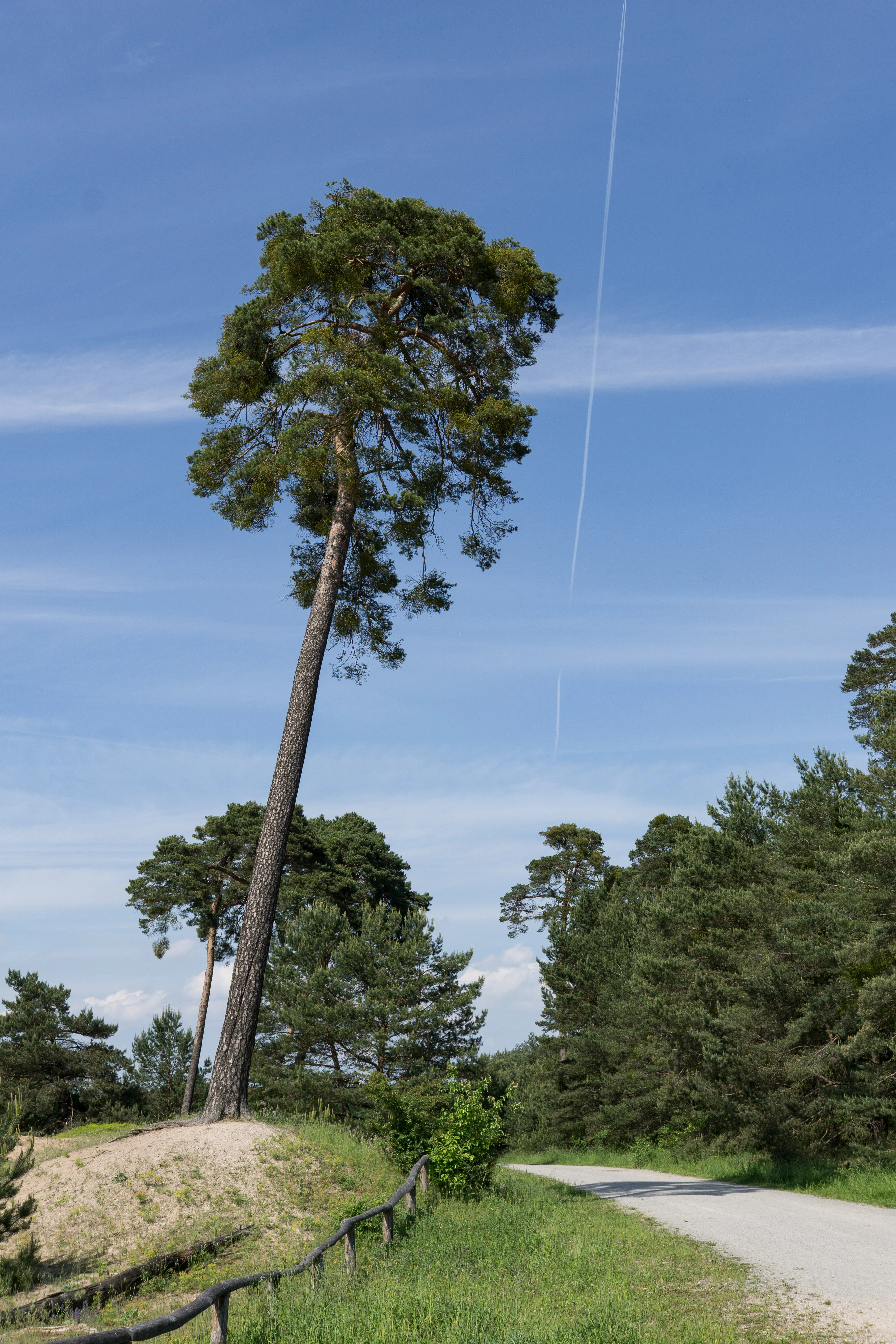
A tall pine tree on a sand dune next to a dirt trail under a blue sky with a contrail.
A lone pine tree stands atop a sandy dune within the Glockenbuckel von Viernheim nature reserve.

Best time to visit Glockenbuckel von Viernheim

The dry grassland character of the reserve is most visible and most ecologically active during the warmer months, when sand temperatures rise quickly and the specialist invertebrates and ground-nesting birds are at their most visible. Late spring and summer bring out the flowering of sand thyme and sand immortelle, and warm evenings and nights are when the nightjar becomes active over the dunes. In winter the site becomes quieter, with bare sand and mosses dominating the open areas, but the surrounding pine stands also take on a more sheltered character. Because the area is actively managed and relatively fragile, any visit benefits from staying on established paths and avoiding disturbance to the open sand patches.

Monthly climate preview

Examine long-term representative temperature and precipitation averages across twelve months.

Glockenbuckel von Viernheim Climate Normals and Annual Weather Patterns

Representative coordinate records show measured temperature swings and steady precipitation rates across the annual cycle at Glockenbuckel von Viernheim. Opening the complete monthly climate breakdown provides deeper reference points for long-term temperature and moisture norms.
Annual mean10 °C
0 °C20 °C
Jan
Feb
Mar
Apr
May14°
Jun18°
Jul20°
Aug20°
Sep15°
Oct10°
Nov
Dec
Warmest month
July

20.3 °C

Coolest month
January

0.1 °C

Wettest month
July

2.4 mm/day

Driest month
April

1.5 mm/day

Park location guide

Geography guide, regional context, and park location map for Glockenbuckel von Viernheim

Glockenbuckel von Viernheim park geography, regions, and map view in Germany

Understand where Glockenbuckel von Viernheim sits in Germany through a broader geographic reading of the surrounding landscape, nearby location context, and its mapped position within the national park landscape.

How Glockenbuckel von Viernheim fits into Germany

Germany is a federal republic in Western and Central Europe with a population of over 83 million across sixteen constituent states. It is Europe's largest economy by nominal GDP and a major global exporter and importer. The capital is Berlin, and the country borders Denmark, Poland, Czech Republic, Austria, Switzerland, France, Luxembourg, Belgium, and the Netherlands.

Wider geography shaping Glockenbuckel von Viernheim in Germany

Germany is located in Western and Central Europe, spanning 357,022 km². It borders Denmark to the north, Poland and the Czech Republic to the east, Austria and Switzerland to the south, and France, Luxembourg, Belgium, and the Netherlands to the west. The country has coastlines on the Baltic Sea and North Sea to the north, with the Alps located in the southern region.

Map view of Glockenbuckel von Viernheim

Use this park location map to pinpoint Glockenbuckel von Viernheim in Germany, understand its exact geographic position, and read its mapped placement within the surrounding landscape more clearly.

Pigeon | © OpenStreetMap contributors

Location context for Glockenbuckel von Viernheim

Hessen

Visualizing the sandy terrain, rare dry grassland habitats, and protected pine-fringed topography of Hesse.

Glockenbuckel von Viernheim Photos: Scenery and Inland Dune Landscapes

Visual documentation reveals the delicate balance of open inland sand dunes and scattered pine stands across the protected Upper Rhine plain. Examining these landscape views clarifies the unique topography and rare habitat conditions preserved within the Hessian nature reserve.

A hoopoe bird with a distinctive crest and black and white striped wings feeds a small chick poking its head out of a hole in a tree trunk.

Close up, macro photograph of a male ladybird spider showing a bright orange abdomen with four black spots against a light, sandy-colored background.

A close up profile view of a natterjack toad sitting partially in shallow water against a blurred, golden-toned background.

A close-up view of a blue-winged grasshopper in mid-air with wings spread, showing clear blue hindwings with dark edges against a blurred background.

A close up view of a Great Golden Digger Wasp with black and orange coloration captured in mid air against a blurred sandy background.

A wide view of a dry, sandy nature reserve in Germany with patches of low, green, yellow-flowering vegetation and scattered pine trees under a clear blue sky with a faint contrail.

A sunny, open landscape with sparse, scrubby pine trees scattered across a grassy, sandy field, with large grey boulders visible in the midground.

A tall pine tree on a sand dune next to a dirt trail under a blue sky with a contrail.

A field covered in yellow blooming ground cover under a partly cloudy sky with a forest line in the background.

A sunny landscape view of a sandy, sparsely vegetated meadow foreground with patches of low yellow-flowering plants, backed by a grove of tall pine trees under a clear blue sky.

A landscape view of a sand dune featuring sparse vegetation with yellow flowers in the foreground, a young pine tree in the center, and a dense line of pine trees in the background under a blue sky.

A wide view of a dry, grassy meadow with scattered pine trees and patches of low-lying yellow-green vegetation under a blue sky with white clouds.

Park atlas

Compare regional nature reserves and protected areas across the Upper Rhine Plain.

Explore Parks Near Glockenbuckel von Viernheim and Surrounding Protected Landscapes

Browse protected areas and sandy reserves adjacent to Glockenbuckel von Viernheim in the southern Hessian landscape. Comparing these neighboring habitats provides deeper context on regional biodiversity and inland dune geography.
A horizontal watercolor painting showing a calm lake or pond surrounded by green trees and shrubs against a soft, light background.
Nature reserveHesse
About 1.9 km away#1 closest

North

Oberlücke von Viernheim Nature Reserve: Mapped Wetland Landscapes in Hesse, Germany

A protected quarry lake refuge for waterbirds and amphibians

The Oberlücke von Viernheim nature reserve represents a significant successional habitat within the Hessian Ried. Formed from an abandoned sand and gravel quarry, its five-hectare water body and surrounding riparian margins serve as a critical wetland sanctuary. This protected area highlights the intersection of industrial legacy and ecological recovery, functioning as a key node for local wildlife in the dense landscape of western Germany.

Area
0.129 km²
Established
1985
IUCN
IV
Relief
Lowland
A soft watercolor illustration depicting a marshy wetland with rolling hills, trees, and tall grasses in a muted, pastel color palette.
Nature reserveHessen
About 4 km away#2 closest

East

Neuzenlache von Viernheim Nature Reserve: Geographic Overview and Protected Landscape Mapping

A rare remnant of an ancient Neckar river arm in Hessen

Neuzenlache von Viernheim offers a focused look at small-scale conservation within the Upper Rhine Plain. This nature reserve provides valuable insight into the transformation of historical river landscapes, featuring a complex of reedbeds and exotic bald cypress trees that mark its unique cultural and natural heritage.

Area
0.091 km²
Established
1990
IUCN
IV
Relief
Lowland
A watercolor painting showing a winding river flowing through a green valley with rolling hills in the background, executed in a soft, impressionistic style with light greens, purples, and pinks.
Protected landscapeRhein-Neckar-Kreis
About 7.9 km away#3 closest

South

Neckartal I-Kleiner Odenwald: Protected Landscape and Regional Geography in Rhein-Neckar-Kreis

Mapping the sandstone ridges and river valley systems of southwestern Germany.

The Neckartal I-Kleiner Odenwald protected landscape serves as a prime example of a transitional natural region where the Neckar river cuts through the Odenwald highlands. This record provides a detailed look at the area's physical geography, including its signature abandoned river bends, block-strewn slopes, and the dense forest canopy that characterizes this significant protected land in the Rhein-Neckar-Kreis district.

Area
63.159 km²
Established
2002
IUCN
V
Relief
Mountain
Protected landscapeBaden-Württemberg
About 11 km away#4 closest

Southwest

Waldpark Mannheim: Protected Floodplain Landscape and Riparian Geography

Natural fluvial terrain along the Rhine in Baden-Württemberg

Waldpark Mannheim encompasses 150 hectares of protected floodplain forest, meadows, and old Rhine river channels. This landscape serves as a crucial ecological zone, defined by shifting water levels and a lack of artificial flood defenses, illustrating the natural rhythm of riparian habitats in southwestern Germany.

Area
1.496 km²
Established
1975
IUCN
V
Relief
Lowland
A soft watercolor painting showing a winding river through a green landscape with soft, rolling hills in the background under a pale sky.
Nature reserveHessen
About 12 km away#5 closest

Northwest

Naturschutzgebiet Lampertheimer Altrhein: Mapped Wetland Nature Reserve in Hessen Germany

Historic Rhine meander and protected bird sanctuary landscape

The Naturschutzgebiet Lampertheimer Altrhein stands as a landmark of floodplain conservation in Hessen, protecting a large-scale former Rhine meander. This reserve integrates shallow oxbow lakes, extensive wet grasslands, and riparian forest into a coherent mosaic of habitats, offering a detailed glimpse into the ecological evolution of the Upper Rhine valley.

Area
5.156 km²
Established
1937
IUCN
IV
Relief
Lowland
A soft watercolor painting depicting a winding river landscape with lush green vegetation, grassy banks, and a treeline in the distance, set against a plain white background.
Nature reserveRheinland-Pfalz
About 13 km away#6 closest

South

Horreninsel Nature Reserve: Detailed Rhine Floodplain Geography and Protected Land Map

A preserved riparian zone in Rheinland-Pfalz, Germany.

Horreninsel represents a significant protected floodplain along the Upper Rhine, featuring a narrow, elongated strip of habitat between the river and its western dike. This reserve hosts diverse terrain, from old river channels and lush Auwald forests to unique Stromtalhalbtrockenrasen dry grasslands, offering a deep look into regional fluvial ecosystems.

Area
0.55 km²
Established
1978
Relief
Lowland
Climate
Temperate
A pale, soft watercolor painting showing a flat, grassy landscape with distant rolling hills and patches of trees.
Nature reserveRhineland-Palatinate
About 13 km away#7 closest

Southwest

Pfälzische Rheinauen Nature Reserve: Protected Alluvial Landscapes in Rhineland-Palatinate

Regional floodplain geography and protected area map context

The Pfälzische Rheinauen is a major landscape protection area encompassing a mosaic of habitats along the Upper Rhine. From the Haardt mountains eastward, this region features rare alluvial forests, reclaimed gravel pit lakes, and complex river systems. It remains a focal point for understanding the integration of floodplain biodiversity with long-standing human activity in Western Germany.

Area
208.33 km²
Established
1971
Relief
Lowland
Climate
Temperate
A soft-focus watercolor painting of a wetland scene showing a calm body of water with reeds in the foreground and a tree-lined horizon under a pastel sky.
Nature reserveHessen
About 14 km away#8 closest

North

Erlache bei Bensheim: Exploring Protected Wetlands and Altneckar Landscapes in Hessen

A distinct nature reserve and bird sanctuary site

The Erlache bei Bensheim nature reserve serves as a critical wetland corridor in the Hessian Rhine plain. This area features a former loop of the River Neckar, now characterized by alder swamp forest, reedbeds, and open water, creating a highly specific ecological terrain surrounded by the regional infrastructure of the Bergstraße district.

Area
0.49 km²
Established
2000
IUCN
IV
Relief
Lowland

Common questions about visiting, size, designation, and location context for Glockenbuckel von Viernheim

Glockenbuckel von Viernheim FAQs for park facts, access, geography, and protected area context

Find quick answers about Glockenbuckel von Viernheim, including protected-area facts, park geography, trail and visitor context, and how the park fits into its surrounding country and regional landscape.
MoriAtlas Explorer

Continue Your Protected Areas Search Across the Global Atlas

Deepen your exploration by continuing the structured search for national parks and protected areas worldwide. Utilize the comprehensive filtering capabilities to compare different conservation landscapes and refine your understanding of global park geography. Discover more about the distribution and characteristics of protected natural areas.

Global natural geography