
Mori Atlas logo
State or regional parkGolden Ears Provincial Park

Mapping the terrain, ecological zones, and expansive boundaries of British Columbia's significant wilderness

Golden Ears Provincial Park: A Comprehensive Geographic Profile of a Coast Mountains Protected Area

Spanning over 62,500 hectares of rugged terrain, Golden Ears Provincial Park represents a vital protected landscape in the Lower Mainland of British Columbia. This expansive wilderness features a complex convergence of the Eastern Pacific Ranges, Southern Pacific Ranges, and the Fraser Lowlands. By integrating glacial lakes and mountain summits, the park offers a detailed study in Pacific Northwest geography and conservation-focused protected area management.

Coast MountainsLower Mainlandtwin peaksAlouette LakePitt LakePacific Northwest forest
A digital illustration showing a snow-capped mountain peak rising above a forest surrounding a calm lake, rendered in a modern flat-art style with a pastel color palette.

Golden Ears Provincial Park

State or regional park

Park overview

Structured park overview, official facts, and landscape profile for Golden Ears Provincial Park

Golden Ears Provincial Park park facts, protected area profile, and essential visitor context

Review the core facts for Golden Ears Provincial Park, including designation, size, terrain, visitor scale, habitats, and operating context in one park-focused overview.

About Golden Ears Provincial Park

Golden Ears Provincial Park is a cornerstone protected area in southwestern British Columbia, occupying a substantial portion of the Coast Mountains immediately north and east of Maple Ridge. The park's identity is inseparable from its namesake summits, the Golden Ears, twin peaks of the Mount Blanshard massif that have served as a regional landmark for generations. Today the park represents one of the most popular and most ecologically significant provincial parks in the Lower Mainland.

The terrain of Golden Ears is layered and varied. Forested valleys carved by rivers and streams descend toward larger lake basins such as Alouette Lake and Pitt Lake, while higher elevations give way to subalpine ridges, rocky slopes, and the jagged peaks of the Golden Ears group. The park's geographic position, where Coast Mountains meet the Fraser Lowlands, produces dramatic transitions over short distances, with coastal rainforest species at lower elevations giving way to montane and subalpine communities higher up.

Recreationally, the park is a hub for outdoor activity in the metro Vancouver region. Visitors come for the trail networks that include the long Golden Ears Trail, which ascends toward the northern summit of the massif, as well as shorter walks and more than 20 kilometres of equestrian trails. Alouette Lake and other water bodies support boating, swimming, and marine camping. The park's accessibility from the Lower Mainland has made it one of the most visited parks in British Columbia, drawing hundreds of thousands of visitors each year.

Ecologically, Golden Ears stands out as a refuge for species at risk. Documented occurrences include more than 85 Red-listed species, ranging from rare plants like Actaea elata to threatened fauna such as the spotted owl and monarch butterfly, alongside Western population grizzly bears identified as a species of special concern. The park also retains stands of trees endemic to the Pacific Northwest, including Sitka spruce, western white pine, Douglas fir, and mountain hemlock, many of which are themselves blue or red listed.

Quick facts and research context for Golden Ears Provincial Park

Golden Ears Provincial Park is one of the largest provincial parks in British Columbia, covering more than 62,000 hectares within the Lower Mainland region near Maple Ridge. Created in 1967 when it was separated from Garibaldi Provincial Park, the park is governed by BC Parks under an IUCN Category II designation.

The park protects part of the Coast Mountains along with portions of the Fraser Lowlands, creating an unusually diverse transition zone within a single protected area. Over 85 BC Red-listed species and roughly 1,800 Blue-listed species have been documented within its boundaries, including species protected under Canada's Species at Risk Act.

Protection and recognition

Terrestrial protection status, management scope, and recognition facts

Golden Ears Provincial Park Protection Status and Designated Area Records

Golden Ears Provincial Park holds documented terrestrial protection status within its regional conservation landscape. Structured records outline the official management scope and available designation history for this protected area.

Protection details

Protection scope
Terrestrial
Transboundary protection
No
Park context

Deeper park guide and search-rich context for Golden Ears Provincial Park

Golden Ears Provincial Park history, landscape, wildlife, and travel context

Explore Golden Ears Provincial Park through its history, landscape character, ecosystems, wildlife, conservation priorities, cultural context, and seasonal travel timing in a structured park guide built for atlas discovery and search intent.

Why Golden Ears Provincial Park stands out

Golden Ears Provincial Park is best known for the commanding twin summits of the Golden Ears massif, with Mount Blanshard reaching 1,716 metres, which rise above the surrounding lakes and forests and define the park's silhouette. The park is also recognized for its unusually large size among Lower Mainland protected areas, combining Coast Mountains terrain with fringe lowland habitats. The park is equally known for its ecological diversity. The meeting of three eco-sections within its boundaries: Eastern Pacific Ranges, Southern Pacific Ranges, and Fraser Lowlands, produces a rich mosaic of Pacific Northwest forest types and supports populations of species at risk, including grizzly bear and spotted owl.
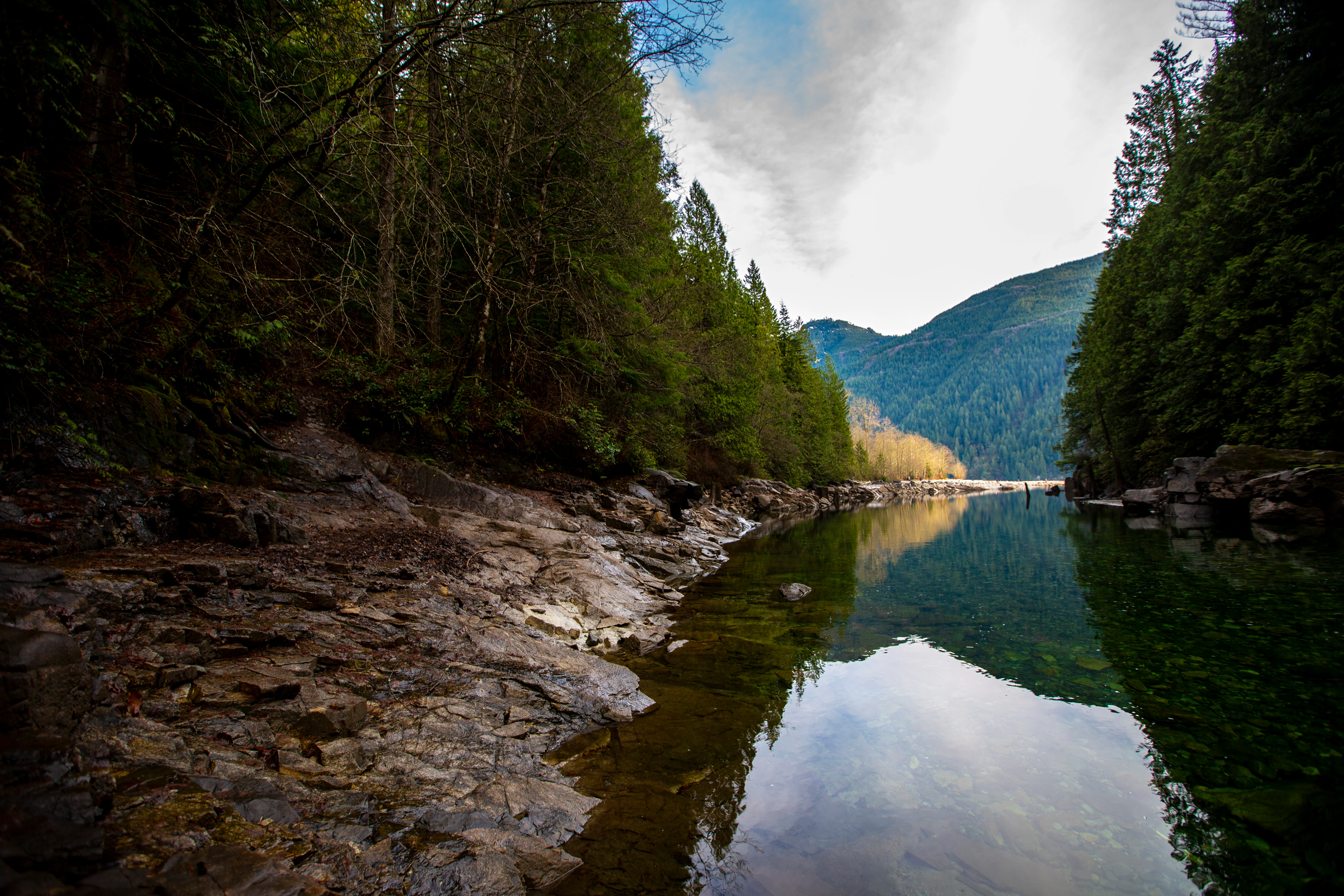
A wide angle view of a calm, reflective river flowing between steep, rocky banks covered in dense evergreen trees.
A calm, reflective river lined with dense coniferous forest in Golden Ears Provincial Park.

Golden Ears Provincial Park history and protected-area timeline

The lands that now form Golden Ears Provincial Park have a layered human and industrial history. The piner, mining, and hydroelectric development that shaped the early twentieth century left enduring marks before conservation planning took hold. The area was logged extensively during the 1920s by the Lougheed and Abernathy Logging Company, at one point the largest logging operation in North America. A major forest fire in 1929 burned an estimated 60,000 hectares and effectively halted logging operations, with most of the old growth cedar and hemlock in the area lost either to harvest or to the blaze.

Mining activity also touched the park. A copper mine was developed in 1897 on the east side of Pitt Lake and changed hands several times before being abandoned during the Great Depression. The broader region is also tied to local legend through the story of Pitt Lake's lost gold mine and the figure of Slumach, a story that has continued to attract public attention, including through the History Channel's documentary series Deadman's Curse.

On the industrial water side, BC Hydro constructed the Alouette Dam on Alouette Lake in 1926 to support power generation, with the resulting reservoir later connected to Stave Lake via a diversion tunnel. The dam blocked historical salmon access into Alouette Lake, an alteration that later became the focus of multi-party restoration efforts.

As a protected area, Golden Ears traces its origin to 1933, when the wider region was incorporated into Garibaldi Provincial Park because of its scenic and recreational value. In 1967, the area now known as Golden Ears was split off as a separate park. The intent was partly to highlight the geographic barrier between the Golden Ears region and the Garibaldi area, and partly to focus management on the recreational assets around Alouette Lake and its surroundings. Improvements in highway access boosted visitation and firmly established Golden Ears as one of British Columbia's most popular provincial parks.

Recognition of the park's First Nations context has grown significantly more recently. The original 1967 Order in Council made no mention of First Nations involvement, but BC Parks has since committed to including First Nations voices in park management decisions. The Katzie First Nation, in particular, has been active in restoration projects, including partnerships with BC Hydro and the Alouette River Management Society aimed at restoring spawning salmon access to Alouette Lake, and studies of plant diversity in the lake's riparian zone.

Golden Ears Provincial Park landscape and geographic character

The landscape of Golden Ears Provincial Park is defined by the contrast between mountain mass and lake basin. The eastern and northern portions of the park rise into the Coast Mountains, culminating in the Golden Ears Group, whose peaks include Mount Blanshard at 1,716 metres. Below these summits, ridges and subalpine bowls descend through forested slopes into the broader valley system.

Much of the park's southern and central landscape is shaped by water. Alouette Lake is a focal feature, bordered by campgrounds, beaches, and recreational areas, while Pitt Lake to the northwest extends deep into the mountains and connects the park to one of the deepest freshwater lakes in North America. The Alouette River, Stave Lake's diversion system, and an extensive network of creeks carve through the terrain, contributing to a system of valleys, riparian flats, and wetlands.

The western fringe of the park transitions into the Fraser Lowlands, producing a softer, lower-elevation landscape that historically supported extensive old growth cedar and hemlock forests. Much of that old growth was removed through early twentieth century logging and fire, but second growth and remnant stands remain a defining element of the park's scenery. Viewpoints such as Viewpoint Beach near Alder Flats offer classic panoramic vistas of the Golden Ears peaks rising above the surrounding forest.
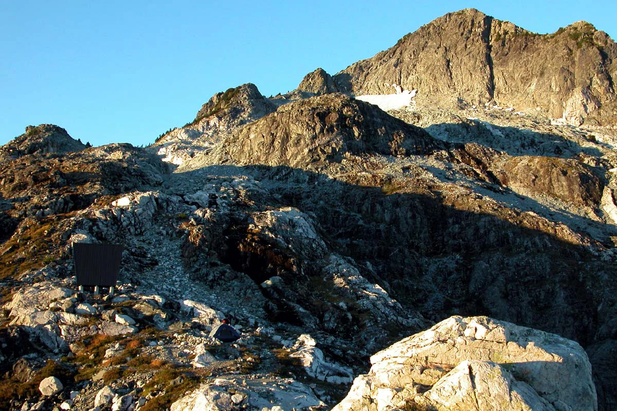
Rugged, rocky alpine peak under clear blue sky with a small emergency shelter visible on the lower left ridge.
The rugged North Summit of Golden Ears, viewed from Panorama Ridge.

Golden Ears Provincial Park ecosystems, habitats, and plant life

Vegetation in Golden Ears Provincial Park reflects the convergence of three ecological sections: the Eastern Pacific Ranges, the Southern Pacific Ranges, and the Fraser Lowlands. This junction creates a notable diversity of plant communities within a relatively compact area, ranging from lowland coastal forest to montane and subalpine vegetation on the higher slopes.

At lower elevations, typical Pacific Northwest forest associations dominate, with stands of Douglas fir, western hemlock, and western redcedar, accompanied by understory species such as western sword fern, leathery grape fern, American parsley fern, and common bracken. Wet areas feature skunk cabbage and salmonberry, while shrub communities include snow bramble and, in disturbed locations, the invasive Himalayan blackberry and various knotweeds. Higher elevations support tree species such as mountain hemlock and western white pine, often in more open and exposed settings.

The park is also notable for its conservation value to rare and endemic plants. Species such as Sitka spruce, western white pine, Douglas fir, and mountain hemlock, considered endemic to the Pacific Northwest, find protected habitat within the park, alongside rare plants like coastal wood fern, Menzies' burnet, and snow bramble. Wetland and riparian habitats around Alouette Lake and along the park's rivers add further ecological complexity.

Golden Ears Provincial Park wildlife and species highlights

Golden Ears Provincial Park supports a wide range of fauna typical of the south Coast Mountains and adjacent lowlands. Historically, the area provided habitat for mule deer, Roosevelt elk, mountain goat, American black bear, North American beaver, and American marten, all of which were important traditional resources for local First Nations. Today the park continues to function as important habitat for several of these species and others.

The park's conservation profile for wildlife is particularly strong. Over 85 BC Red-listed species have been documented, including the spotted owl and monarch butterfly, both of which appear on Schedule 1 of Canada's Species at Risk Act. The Western population of grizzly bears, listed as a species of special concern under the same act, has been documented among the park's approximately 1,800 Blue-listed species. The park's riparian and aquatic environments also support Pacific salmon (five species historically harvested from Alouette Lake and the Alouette River), steelhead, sturgeon, and trout, with restoration efforts focused on re-establishing salmon access to historic spawning habitat.

Golden Ears Provincial Park conservation status and protection priorities

Golden Ears Provincial Park is a high-priority conservation area within British Columbia's protected areas network. The combination of mountain and lowland ecosystems within a single park creates a refuge for numerous at-risk species, and the park has been formally recognized through the official Golden Ears Park Management Plan enacted in November 2013.

The management plan reflects the pressures associated with being one of the most visited parks in the province, drawing an average of roughly 610,000 visitors annually. It focuses on mitigating erosion from heavily used hiking trails and shoreline erosion from water-based recreation, while supporting research into the park's wildlife populations and recovery initiatives for endangered species. The plan also recognizes the importance of controlling invasive species such as Himalayan blackberry and knotweed, which have the potential to disrupt native plant communities.

Conservation in Golden Ears also extends to cultural and ecological restoration. Efforts led by the Katzie First Nation with BC Hydro and the Alouette River Management Society have aimed at restoring spawning salmon to Alouette Lake, blocked since the construction of the Alouette Dam in 1926, alongside studies of plant diversity in the Alouette Lake riparian zone. These initiatives illustrate a model of conservation that integrates ecological recovery with First Nations leadership.

Golden Ears Provincial Park cultural meaning and human context

The lands within Golden Ears Provincial Park fall within the traditional territory of the Coast Salish peoples. Several First Nations have historic and ongoing relationships with the area, including the Katzie, Kwantlen, Matsqui, Sts'Ailes, Tsawwassen, Stó:lō, In-SHUCK-ch, and St'at'imc/Lillooet peoples, whose territories collectively overlap the entire park.

Traditionally, the area served as an important source of sustenance. The Katzie First Nation used what are now the southern and western portions of the park for hunting and fishing, and several culturally important Katzie sites are located within park boundaries. The St'at'imc/Lillooet people used the northern part of what is now Golden Ears as a trade corridor, while the Kwantlen used the southeastern portion for hunting and trapping. Plants gathered in the area historically included cedar bark, wapato, cranberries, and other berries.

Fishing has a particularly deep history around Alouette Lake and the Alouette River, where archaeological evidence indicates fishing activity spanning several thousand years. Species historically harvested included five species of Pacific salmon, steelhead, sturgeon, and trout. The construction of the Alouette Dam in 1926 interrupted salmon access, and the Katzie First Nation has been central to efforts to restore that access.

Today, the local Nations retain rights to gather resources within the park, with hunting and trapping limited to members of these communities. The Katzie Cultural Education Society runs educational programs at the park's Outdoor Learning Centre, and BC Parks has committed to including First Nations voices in management decisions, an approach formalized in the Golden Ears Park Management Plan.

Top sights and standout views in Golden Ears Provincial Park

Golden Ears Provincial Park stands out for the combination of scale and accessibility. Few other parks in the Lower Mainland offer such an extensive network of Coast Mountains terrain, glacial lakes, and subalpine ridges within a short drive of a major urban center. The Golden Ears peaks themselves, with Mount Blanshard's summit reaching 1,716 metres, are among the most recognizable mountain landmarks in the region.

The park's ecological concentrations are another defining highlight. With three eco-sections meeting within its boundaries and more than 85 Red-listed species documented, Golden Ears offers an unusually rich conservation context. Trails such as the Golden Ears Trail, the West Canyon Trail, and the network around Alouette Lake give visitors direct access to the full range of that ecological diversity, from lakeshores and riparian flats to high subalpine ridges.

Best time to visit Golden Ears Provincial Park

The character of Golden Ears Provincial Park shifts meaningfully with the seasons. Summer is the most active period, with warm weather opening up the full range of camping, boating, and hiking opportunities, and the network of lakeside beaches and campgrounds around Alouette Lake drawing the largest crowds. Trail conditions are generally most accessible in this period, although higher elevation routes, including the Golden Ears Trail itself, can retain snow and challenging conditions well into the summer months.

Spring and fall tend to bring quieter conditions and shifting scenery, with fresh greens in late spring and vivid autumn color in the subalpine forests later in the year. Gold Creek campground is the only one of the park's three main campgrounds open year-round, with amenities restricted during winter. In winter, the park transitions primarily to a quieter landscape of snow-covered trails, frozen lake edges, and reduced accessibility to backcountry areas, attractive for visitors seeking solitude rather than full summer amenity access.
Monthly climate preview

Long-term temperature ranges and monthly precipitation averages for Golden Ears Provincial Park

Golden Ears Provincial Park Climate Normals and Annual Weather Patterns

Representative coordinate records outline the measured annual temperature rhythm and monthly precipitation totals across Golden Ears Provincial Park. Detailed twelve-month climate profiles provide comprehensive long-term data for deeper geographical comparison.
Annual mean5 °C
-4 °C15 °C
Jan-3°
Feb-3°
Mar
Apr
May
Jun12°
Jul15°
Aug15°
Sep12°
Oct
Nov
Dec-4°
Warmest month
July

15.4 °C

Coolest month
December

-3.7 °C

Wettest month
November

11.9 mm/day

Driest month
July

2.2 mm/day

Park location guide

Geography guide, regional context, and park location map for Golden Ears Provincial Park

Golden Ears Provincial Park park geography, regions, and map view in Canada

Understand where Golden Ears Provincial Park sits in Canada through a broader geographic reading of the surrounding landscape, nearby location context, and its mapped position within the national park landscape.

How Golden Ears Provincial Park fits into Canada

Canada is a federal parliamentary constitutional monarchy spanning North America from the Atlantic to the Pacific and Arctic Oceans. With a population of over 41 million, it is officially bilingual in English and French at the federal level. The country gained independence from the United Kingdom through a gradual process culminating in 1982.

Wider geography shaping Golden Ears Provincial Park in Canada

Canada occupies the northern portion of North America, sharing its longest international border with the United States. The country extends from the Atlantic Ocean to the Pacific Ocean and northward into the Arctic Ocean, giving it the longest coastline of any nation.

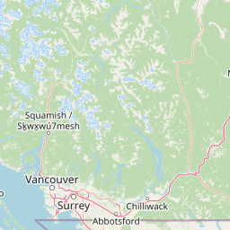
Map view of Golden Ears Provincial Park

Use this park location map to pinpoint Golden Ears Provincial Park in Canada, understand its exact geographic position, and read its mapped placement within the surrounding landscape more clearly.

Pigeon | © OpenStreetMap contributors

Location context for Golden Ears Provincial Park

British Columbia
Recorded earthquake history

Review the Historical Earthquake Catalogue for Golden Ears Provincial Park

Examine the record of seismic events detected near the boundaries of Golden Ears Provincial Park. This MoriAtlas collection offers a structured look at historical earthquake data, allowing for direct review of magnitudes and epicentre proximity within this significant protected region.

Golden Ears Provincial Park Earthquake History

Catalogued events

11 events

Strongest magnitude

Magnitude 4.3

Most recent event

Jul 5, 2015

This history includes earthquakes recorded inside the park or within 50 km of its borders

Explore photographic records of twin peaks, glacial lakes, and Pacific Northwest forest zones.

Golden Ears Provincial Park Photos and Landscapes: Visualizing Coast Mountains Scenery

Visual documentation captures the rugged topography of Coast Mountains terrain, alpine ridges, and deep lake basins across the protected landscape. Examining photographic framing reveals the ecological diversity and massive scale defining the regional environment.

A wide angle view of a calm, reflective river flowing between steep, rocky banks covered in dense evergreen trees.

A panoramic mountain landscape showing snow capped twin peaks partially obscured by clouds above a dense evergreen forest.

Rugged, rocky alpine peak under clear blue sky with a small emergency shelter visible on the lower left ridge.

Park atlas

Compare adjacent mountain terrain and connected regional protected areas

Explore Parks Near Golden Ears Provincial Park and Surrounding Protected Landscapes

Browse other parks near Golden Ears Provincial Park to examine similar Coast Mountains terrain and regional valley ecosystems. Expanding the geographic view reveals connected protected landscapes across the surrounding region.
A horizontal watercolor painting depicting a light, airy landscape with distant snow-capped mountains, rolling green hills, and coniferous forest edges.
State or regional parkBritish Columbia
Park boundaries overlap#1 closest

Northwest

Garibaldi Provincial Park: An Atlas of Volcanic and Glacial Terrain in British Columbia

Protected wilderness in the Garibaldi Volcanic Belt

Garibaldi Provincial Park preserves a massive expanse of mountainous wilderness, defined by iconic landmarks such as The Black Tusk and Garibaldi Lake. The park represents a crucial study in vertical zonation, transitioning from temperate coastal forests to vast alpine meadows, glaciers, and jagged volcanic summits. Analyze the geological history and mapped protected boundaries that shape this significant British Columbia conservation area.

Area
1,950 km²
Established
1920
IUCN
II
Visitors
136K annual
A watercolor illustration of a mountain landscape featuring soft rolling hills, evergreen trees, and low-lying vegetation on a white background.
State or regional parkBritish Columbia
1.4 km away#2 closest

West

Pinecone Burke Provincial Park: Coast Mountain Wilderness and Protected Terrain Geography

Mapping a vast ecological corridor in British Columbia

Spanning over 38,000 hectares, Pinecone Burke Provincial Park represents a dramatic transition from the urban proximity of Coquitlam to the remote interiors of the southern Coast Mountains. The landscape is defined by its rugged relief, featuring subalpine meadows, deep freshwater systems, and historically significant forested slopes. This park provides a critical look at the complex topography of the Pacific Northwest, serving as a sanctuary for wildlife and a foundational piece of regional conservation.

Area
380 km²
Established
1995
IUCN
II
Relief
Mountain
A soft watercolor painting of a landscape featuring a lake, low rolling hills in the background, and grassy vegetation along the foreground shoreline under a warm, pale yellow sky.
State or regional parkFraser Valley Regional District
About 8.1 km away#3 closest

South

Rolley Lake Provincial Park: An Atlas of Protected Landscapes and Regional Geography

Lakeshore forest terrain and protected park geography

Delve into the geographic identity of Rolley Lake Provincial Park, a state-protected landscape in the Fraser Valley Regional District. This documentation traces the park's internal map, including its central freshwater lake, loop trail connectivity, and surrounding second-growth forest topography, providing essential context for understanding this localized wilderness zone.

Area
1.15 km²
Established
1961
IUCN
II
A watercolor painting showing a soft, hazy landscape of a lake with green forest along the shore and distant purple mountains under a pale sky.
State or regional parkBritish Columbia
About 12 km away#4 closest

Southeast

Davis Lake Provincial Park: Protected Forest and Lake Geography in British Columbia

Regional protected area with old-growth forest and waterfalls

Davis Lake Provincial Park represents a significant protected area in the Fraser Valley, characterized by its undisturbed Western Hemlock forest and the scenic descent of Murdo Creek into McDonald Falls. The park provides an essential look at the regional geography of southwestern British Columbia, balancing dense coniferous canopy with accessible lake-based terrain in a quiet, natural setting.

Area
0.75 km²
Established
1963
IUCN
II
Relief
Upland
A horizontal watercolor painting depicting a soft-toned landscape with green trees, rolling hills, a calm body of water, and distant pale mountains.
State or regional parkBritish Columbia
30 km away#5 closest

Southwest

Peace Arch Park: Mapped Geography and Protected Landscapes of the Canada and US Border

Coastal binational protected area in British Columbia

Peace Arch Park is a notable protected landscape positioned directly on the international border. This site acts as a continuous green space between Canada and the United States, offering an unusual study of territorial boundaries and coastal geography. Spanning manicured terrain and historic monument grounds, the park provides an essential vantage point for understanding land-based connectivity in the Pacific Northwest region.

Area
0.17 km²
Established
1939
Visitors
500K annual
Access
Easy access
State or regional parkBritish Columbia
About 31 km away#6 closest

Southeast

Kilby Provincial Park: Protected Riverfront Geography and Historic Sites in BC

A unique riparian landscape along the Harrison River

Kilby Provincial Park offers an intimate look at the flood plain geography of the Harrison River. The site features an elevated, boardwalk-linked heritage environment integrated with sandy riverfronts and seasonal wildlife corridors. This protected area stands out for its combination of historical pioneer preservation and river-based ecosystem monitoring within the Upper Fraser Valley region of British Columbia.

Area
0.03 km²
Established
1973
IUCN
II
Relief
Lowland
State or regional parkBritish Columbia
About 44 km away#7 closest

Southeast

Ferry Island Provincial Park: Geography, Riparian Terrain, and Protected River Boundaries

A study of Fraser River alluvial landscapes and provincial park land use

Ferry Island Provincial Park provides a rare protected island setting along the Fraser River in British Columbia. Spanning 29 hectares near the Agassiz-Rosedale Bridge, this Class C park represents an important alluvial riparian ecosystem within the heavily cultivated Fraser Valley, offering key insights into regional river-corridor geography and protected land management.

Area
0.29 km²
Established
1963
IUCN
II
Access
Access unknown
A horizontal watercolor illustration depicting soft green rolling hills and distant purple mountains above a flat shoreline with patches of marsh grasses.
State or regional parkBritish Columbia
47 km away#8 closest

West

Porteau Cove Provincial Park: Mapping Coastal Protected Landscapes in British Columbia

Geography of Howe Sound shorelines and marine habitats

Porteau Cove Provincial Park offers a unique geographic vantage point at the meeting of granite-sloped mountains and the Pacific waters of Howe Sound. This park detail covers the coastal landscape, including protected intertidal zones, artificial reef structures, and the surrounding terrain that characterizes this segment of the British Columbia coastline.

Area
0.5 km²
Established
1981
IUCN
II
Visitors
611.8K annual

Common questions about visiting, size, designation, and location context for Golden Ears Provincial Park

Golden Ears Provincial Park FAQs for park facts, access, geography, and protected area context

Find quick answers about Golden Ears Provincial Park, including protected-area facts, park geography, trail and visitor context, and how the park fits into its surrounding country and regional landscape.
MoriAtlas Explorer

Continue Your Protected Areas Search Across the Global Atlas

Deepen your exploration by continuing the structured search for national parks and protected areas worldwide. Utilize the comprehensive filtering capabilities to compare different conservation landscapes and refine your understanding of global park geography. Discover more about the distribution and characteristics of protected natural areas.

Global natural geography