

Mori Atlas logo
National parkGoobang National Park

Discover the mapped boundaries and landscape context of this designated national park.

Goobang National Park: New South Wales Protected Area and Geographic Atlas

Goobang National Park is a protected natural landscape situated within New South Wales, Australia. This page provides an atlas-centered view of the park, focusing on its geographic identity, mapped boundaries, and the surrounding regional context. Understand its place within the broader geography of New South Wales through detailed mapping and protected-area data.

Woodland conservationNew South Wales national parksEucalyptus forestsProtected wildlife habitatCentral west NSWAustralian wildlife

Goobang National Park

National park

Park overview

Structured park overview, official facts, and landscape profile for Goobang National Park

Goobang National Park park facts, protected area profile, and essential visitor context

Review the core facts for Goobang National Park, including designation, size, terrain, visitor scale, habitats, and operating context in one park-focused overview.

About Goobang National Park

Goobang National Park occupies a distinctive position in New South Wales' protected area network as the largest remnant forest and woodland in the state's central west region. The park's landscape is dominated by the Hervey Range, a mountain range that creates a complex topography of ridges, valleys, and plateaus supporting diverse vegetation communities. This geographic position creates an ecological crossroads where species from interior arid and semi-arid zones meet those from the coastal plains, resulting in unusual species combinations and high biodiversity. The park is managed by the New South Wales National Parks and Wildlife Service and provides essential ecosystem services including watershed protection, soil conservation, and climate regulation. Visitors can access a camping ground and the Burrabadine Peak Walking Track, a moderate 3.6-kilometer round-trip hike that rewards walkers with sweeping views from Caloma lookout across the timbered ranges. The park's value extends beyond recreation to serve as a living laboratory for ecological research and a repository for genetic diversity in a landscape largely cleared for agriculture throughout the surrounding region.

Quick facts and research context for Goobang National Park

Goobang National Park covers 421 square kilometers in central west New South Wales, situated about 296 kilometers northwest of Sydney near the city of Parkes. The area was originally named Hervey Range by explorer John Oxley in 1817 and was reserved as state forest in 1897 due to its valuable timber resources before achieving national park status in December 1995. The park sits within a temperate to semi-arid climate zone with hot summers and cool winters, experiencing its heaviest rainfall during summer months. It contains 459 recorded plant species and supports 31 mammal species, 31 reptile species, 14 frog species, and numerous bird species, several of which are threatened. The park features 11 distinct ecological communities, with five of these communities found only within Goobang, making it particularly significant for conservation.

Protection and recognition

Verifying the terrestrial management scope, historical designation, and official conservation data

Goobang National Park Protected Area Designation and Recognition Profile

Established in 1995, Goobang National Park represents a dedicated terrestrial protected area managed under regional conservation frameworks. Natural geographic explorers can trace the formal protection status, boundary scope, and historical designation records that define the regional conservation landscape.

Protection details

Protection scope
Terrestrial
Designated year
1995
Transboundary protection
No
Park context

Deeper park guide and search-rich context for Goobang National Park

Goobang National Park history, landscape, wildlife, and travel context

Explore Goobang National Park through its history, landscape character, ecosystems, wildlife, conservation priorities, cultural context, and seasonal travel timing in a structured park guide built for atlas discovery and search intent.

Why Goobang National Park stands out

Goobang National Park is best known for protecting the largest remaining forest and woodland tract in central west New South Wales, a region where inland and coastal species intermix. The park's significance is underscored by its five endemic ecological communities that exist nowhere else, including red stringybark woodland on siliceous hillslopes, black cypress pine hummock grass shrubland on volcanic and sedimentary ranges, and red ironbark shrubby woodland on sandy soils derived from sandstone. The park provides crucial habitat for several threatened species including the koala, carpet python, brush-tailed rock wallaby, and the endangered regent honeyeater. Burrabadine Peak Walking Track offers a 3.6-kilometer round-trip hike to panoramic views from Caloma lookout, showcasing the park's diverse woodland scenery.

Goobang National Park history and protected-area timeline

The history of Goobang National Park reflects broader patterns of Australian colonial exploration, resource exploitation, and eventual environmental conservation. The area was first recorded by European explorers when John Oxley named the range Herveys Range in 1817 during an expedition through inland New South Wales. Recognizing the timber value of the tall eucalyptus forests and cypress woodlands, the colonial government reserved the area as state forest in 1897, making it one of the earliest reserved timber areas in the central west region. For nearly a century, the forest was managed primarily for timber production, with various selective harvesting and fire management practices employed. Growing recognition of the area's ecological significance, particularly its role as a biodiversity refuge in an increasingly cleared agricultural landscape, led to its redesignation as a national park on 22 December 1995. This transition marked a shift from extractive use to conservation priority, though the park's management continues to address challenges from its historical uses including altered fire regimes and invasive species.

Goobang National Park landscape and geographic character

The landscape of Goobang National Park is characterized by the ancient Hervey Range, a series of ridges and valleys carved from sedimentary and volcanic substrates. The terrain ranges from steep sandstone ridgelines to gentle slopes and valley floors, creating a diverse topography that influences local climate, drainage, and vegetation patterns. The park spans a climatic transition zone between the temperate coastal influences and the semi-arid interior, resulting in a landscape of mixed woodland character. Ridges are typically covered in open forests of ironbark and stringybark species, while valley floors support more dense woodlands of box and gum species along watercourses. The combination of sandstone and volcanic geology creates varied soil types that support distinct plant communities, from heathland on acidic siliceous ridges to shrubby woodlands on deeper valley soils. The park's visual character is quintessentially Australian woodland, with gnarled eucalypts, cypress pines, and an understory of native grasses and shrubs across rolling hills.

Goobang National Park ecosystems, habitats, and plant life

The ecological character of Goobang National Park is defined by its position at a biogeographic crossroads and the diversity of microhabitats created by its complex terrain. The park contains 459 recorded plant species across 11 distinct ecological communities, with five of these communities found only within Goobang, making it critically important for regional biodiversity conservation. The dominant vegetation includes various eucalyptus associations such as red stringybark, red ironbark, mugga ironbark, and scribbly gum, often in combination with black cypress pine and diverse understory species. Several plant species are threatened, including Tylophora linearis listed as vulnerable under state legislation and endangered under federal law, Pomaderris queenslandica, and Astrotricha linearis which has its only known record west of the Great Dividing Range within this park. The park also protects significant fragments of white box woodland, a community that has been heavily cleared throughout its former range for agriculture. This ecological diversity supports a corresponding richness of fauna, with 31 mammal species, 31 reptile species, and 14 frog species recorded within the park boundaries.

Goobang National Park wildlife and species highlights

Goobang National Park supports a rich fauna community across its woodland and forest habitats, with 31 mammal species, 31 reptile species, and 14 frog species documented within the park. Mammals include common species such as echidnas, various wallaby and kangaroo species, possums, and bats, alongside threatened species that depend on the park's old-growth trees and rock shelters. The koala, listed as endangered in some Australian states, finds important habitat within the park's eucalyptus woodlands, though populations face pressures from disease, drought, and habitat fragmentation. The brush-tailed rock wallaby inhabits rocky outcrops and cliff lines, while the grey-headed flying-fox roosts in dense vegetation and serves as an important pollinator. Reptile diversity includes carpet pythons and various skink and dragon species, while frogs occupy the park's creeks and temporary water bodies. The avifauna is particularly significant, with birds such as the endangered regent honeyeater, painted honeyeater, varied sittella, and glossy black cockatoo recorded in the park's woodlands. Many woodland bird species are declining throughout Australia due to habitat clearing, making Goobang's protected woodlands increasingly important for their survival.

Goobang National Park conservation status and protection priorities

Goobang National Park represents a critical conservation asset in a largely cleared agricultural landscape, protecting the largest remaining forest and woodland tract in central west New South Wales. The park's significance is amplified by five ecological communities that exist only within its boundaries, representing irreplaceable genetic reservoirs and habitat types. Conservation challenges include managing the impacts of feral animals such as cats, foxes, rabbits, goats, and dogs that predate native wildlife and compete for resources, while environmental weeds particularly blackberry form dense thickets that alter native vegetation structure. Agricultural practices surrounding the park, including grazing and vegetation clearing for crop production, threaten to sever wildlife corridors between the park and remaining woodland fragments. Climate change poses an increasingly serious threat, with projections suggesting significant impacts on frog and bird populations, while koalas face particular risks from changing eucalyptus leaf nutrition, increased drought frequency, and more intense bushfire regimes. The park employs prescribed burning to maintain biodiversity, recognizing that fire is an intrinsic feature of Australian ecosystems despite the risks of wildfire from dry lightning strikes.

Goobang National Park cultural meaning and human context

Goobang National Park exists within the traditional Country of Aboriginal peoples, though the source material does not provide detailed information about specific Indigenous connections to this landscape. The park's European history dates to early colonial exploration when John Oxley named the Hervey Range in 1817, and subsequent timber extraction shaped the landscape through nearly a century of state forest management before national park designation in 1995. The surrounding agricultural region has been extensively cleared for cropping and grazing, making the park's preserved woodlands increasingly significant as a cultural and ecological reference point for understanding the pre-colonial landscape. Place names in the region, including the park's name derived from the Indigenous term for the area, reflect the long human presence in this landscape even if specific traditional knowledge is not documented in available sources.

Top sights and standout views in Goobang National Park

The largest remaining forest and woodland in central west New South Wales makes Goobang a flagship conservation area for the region, protecting five ecological communities found nowhere else on Earth. The park provides essential habitat for threatened species including koalas, carpet pythons, brush-tailed rock wallabies, and the endangered regent honeyeater. Caloma lookout offers panoramic views across timbered ridges and valleys along the Burrabadine Peak Walking Track, a 3.6-kilometer moderate hike. The park's position at the overlap between interior and coastal NSW species creates unique ecological assemblages not found in other protected areas. Visitors can camp within the park and explore diverse vegetation communities ranging from ironbark ridges to box-gum valley forests.

Best time to visit Goobang National Park

Goobang National Park can be visited throughout the year, with each season offering different experiences of the park's woodland landscapes. Autumn and spring generally offer mild daytime temperatures comfortable for hiking and wildlife observation, with wildflower displays in spring adding color to the woodland understory. Summer brings warmer conditions with daytime temperatures ranging from 17 to 32 degrees Celsius and the heaviest rainfall, which can make some tracks muddy and difficult while also supporting frog activity in creeks and ponds. Winter temperatures drop to between 4 and 15 degrees Celsius, offering cool conditions for extended walks but requiring warm clothing for early mornings and evenings. The park's semi-arid character means that conditions can be dry for much of the year, so visitors should carry adequate water regardless of season and check current fire restrictions before visiting.
Monthly climate preview

Long term representative measurements tracking monthly temperature and precipitation patterns

Goobang National Park Climate Normals and Annual Temperature Rhythm

Representative coordinate records establish the measured annual temperature and precipitation rhythm across Goobang National Park from 1991 to 2020. Detailed month by month climate normals provide deeper analytical context for the complete meteorological profile.
Annual mean18 °C
8 °C27 °C
Jan27°
Feb26°
Mar22°
Apr18°
May13°
Jun10°
Jul
Aug10°
Sep14°
Oct18°
Nov22°
Dec24°
Warmest month
January

26.9 °C

Coolest month
July

8.5 °C

Wettest month
December

2 mm/day

Driest month
April

1 mm/day

Park location guide

Geography guide, regional context, and park location map for Goobang National Park

Goobang National Park park geography, regions, and map view in Australia

Understand where Goobang National Park sits in Australia through a broader geographic reading of the surrounding landscape, nearby location context, and its mapped position within the national park landscape.

How Goobang National Park fits into Australia

Australia is a constitutional monarchy and federal parliamentary democracy comprising six states and ten territories. With a population of nearly 28 million, it is one of the world's most urbanised countries, with most people concentrated on the eastern seaboard. The country has a high Human Development Index and is known for its cultural diversity, ancient Aboriginal heritage, and unique wildlife.

Wider geography shaping Goobang National Park in Australia

Australia occupies the entire Australian continent, the island of Tasmania, and numerous smaller islands. It is the world's flattest and driest inhabited continent, featuring vast deserts in the interior (the Outback), tropical rainforests along the eastern coast, and a coastline bordering the Indian and Pacific Oceans.

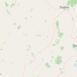
Map view of Goobang National Park

Use this park location map to pinpoint Goobang National Park in Australia, understand its exact geographic position, and read its mapped placement within the surrounding landscape more clearly.

Pigeon | © OpenStreetMap contributors

Location context for Goobang National Park

New South Wales
Natural feature types

Browse the Detailed Natural Features and Topography of Goobang National Park

Examine the specific landforms, ridges, and valleys that characterize the landscape of Goobang National Park. Use this collection to map the diverse terrain and ecological features that make this New South Wales protected area a significant geographic landmark within the MoriAtlas ecosystem.
Recorded earthquake history

Review the Historical Earthquake Catalogue for Goobang National Park

Access a detailed record of seismic events documented near Goobang National Park. MoriAtlas provides this historical catalogue for geographic context, allowing users to review documented earthquake data, magnitudes, and epicentre proximity within the surrounding New South Wales landscape.

Goobang National Park Earthquake History

Catalogued events

6 events

Strongest magnitude

Magnitude 3.8

Most recent event

Mar 18, 2008

This history includes earthquakes recorded inside the park or within 50 km of its borders

Park atlas

Map Goobang's surrounding protected landscapes and compare nearby national parks across New South Wales' unique woodland regions.

Discover Other National Parks Near Goobang National Park, Central West New South Wales

Explore other protected areas and national parks situated within Goobang National Park's regional context, tracing the diverse woodland and forest ecosystems of central west New South Wales. Compare terrain, conservation landscapes, and ecological interfaces as you broaden your discovery from Goobang across geographically adjacent protected areas.
Nature reserveNew South Wales
About 13 km away#1 closest

Southeast

South West Woodland Nature Reserve: Geographic Overview and Protected Forest Boundaries

A fragmented network of conservation precincts in inland New South Wales

Examine the geographic structure of South West Woodland Nature Reserve, a nature reserve defined by its unusual patchwork of twenty-seven isolated woodland islands. Stretching across 400 kilometres, this protected area anchors crucial white cypress pine and eucalypt forest remnants, forming a transition zone between the South Western Slopes and the arid plains of the Murray Darling Depression.

Area
138.4 km²
Established
2011
IUCN
Ia
Relief
Lowland
National parkNew South Wales
20 km away#2 closest

South

Nangar National Park: Australian National Park Geography and Mapped Boundaries

Explore the protected landscape within New South Wales.

Nangar National Park is a key protected area situated in New South Wales, Australia, offering a valuable point for geographic discovery. This page details its status as a national park, providing insight into its mapped boundaries and its role within the regional landscape. Users can utilize this information to understand the park's specific geographic context and its contribution to the broader atlas of Australia's protected lands.

Area
94 km²
Established
1983
IUCN
II
Relief
Mountain
Nature reserveNew South Wales
About 41 km away#3 closest

Southeast

Borenore Karst Conservation Reserve: Exploring Limestone Caves and Volcanic Geology

Protected karst landscapes and fossil heritage in New South Wales

Borenore Karst Conservation Reserve offers a dense concentration of limestone features, including the notable Tunnel Cave and expansive fossil-rich sediments. Its geographic identity is defined by the striking contrast between its sedimentary core and the surrounding volcanic terrain of the Central Tablelands, providing a distinct site for investigating regional earth sciences and subterranean ecology.

Area
1.36 km²
Established
1997
IUCN
III
Relief
Upland
Nature reserveNew South Wales
About 51 km away#4 closest

East

Wellington Caves Nature Reserve: Mapping Limestone Formations and Pleistocene Fossil Sites

Geological atlas of subterranean karst landscapes in New South Wales

The Wellington Caves reserve features a rich subterranean geography shaped by water working through Devonian limestone. Explore the site's mapped network of chambers, including Cathedral Cave and its massive Altar Rock, alongside historic fossil deposits that have shaped Australian paleontology since the 1830s. This protected landscape offers a unique look at karst evolution and subterranean lake systems within the Australian bush.

Established
1884
Visitors
35K annual
Relief
Upland
Scope
Terrestrial
National parkNew South Wales
53 km away#5 closest

South

Conimbla National Park: Protected Landscape Atlas and Regional Geography

Mapped boundaries and terrain within New South Wales.

Examine the protected landscape of Conimbla National Park, a designated national park situated in New South Wales, Australia. This entry provides focused geographic context, detailing its mapped boundaries and the regional terrain. It serves as a valuable resource for understanding the park's identity within the national atlas and its specific place in the Australian landscape.

Area
84.71 km²
Established
1980
IUCN
II
Relief
Upland
National parkNew South Wales
84 km away#6 closest

South

Weddin Mountains National Park: National Park Mapping and Geographic Context

Discover mapped protected landscape boundaries in New South Wales.

Weddin Mountains National Park represents a key protected area within New South Wales, Australia, offering a focused lens for geographic exploration. This detail page provides access to the park's specific mapped boundaries and its role as a national park. Understand the surrounding regional geography and the protected landscape's identity through a detailed atlas perspective, ideal for mapping conservation areas.

Area
83.61 km²
Established
1971
IUCN
II
Relief
Mountain
National parkAustralia
About 100 km away#7 closest

Northeast

Yarrobil National Park: Australia's Protected Landscape for Geographic Discovery

Explore its national park designation and mapped regional context.

Yarrobil National Park stands as a distinct protected landscape within Australia, identified as a national park. Its geographic significance lies in its contribution to the nation's atlas of conservation areas. This page focuses on providing a clear understanding of the park's identity, its environmental setting, and how its mapped boundaries fit into the broader regional geography of Australia, enabling structured exploration for enthusiasts of protected areas and natural landscapes.

Area
13.22 km²
Established
2005
IUCN
II
Relief
Upland
Natural monumentNew South Wales
About 116 km away#8 closest

Southeast

Abercrombie Caves: Protected Karst Landscape and Geological Monument in New South Wales

Exploration of karst formations and cave morphology

Abercrombie Caves preserve a sophisticated limestone karst system within the Central West region of New South Wales. The reserve is anchored by The Archway, a massive natural bridge sculpted by water erosion, alongside various chambers including King Solomon's Temple and Bushranger's Cave. This natural monument highlights the interplay between rugged range geography, solutional cave development, and the site's enduring historical significance as a former gold-mining and bushranger landscape.

Area
14.34 km²
Established
1997
IUCN
III
Relief
Upland

Common questions about visiting, size, designation, and location context for Goobang National Park

Goobang National Park FAQs for park facts, access, geography, and protected area context

Find quick answers about Goobang National Park, including protected-area facts, park geography, trail and visitor context, and how the park fits into its surrounding country and regional landscape.
MoriAtlas Explorer

Continue Your Protected Areas Search Across the Global Atlas

Deepen your exploration by continuing the structured search for national parks and protected areas worldwide. Utilize the comprehensive filtering capabilities to compare different conservation landscapes and refine your understanding of global park geography. Discover more about the distribution and characteristics of protected natural areas.

Global natural geography