
Mori Atlas logo
National parkGorczański Park Narodowy

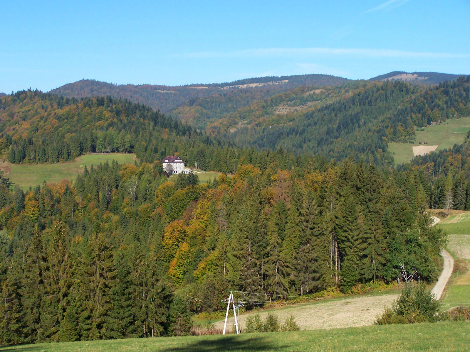
A detailed map and landscape overview of the forested Gorce massif in southern Poland

Gorczański Park Narodowy: Protected Carpathian Forests and Mountain Summit Geography

Gorczański Park Narodowy preserves the central range of the Gorce Mountains, featuring expansive old-growth beech and fir forests interspersed with traditional grassy clearings. Located within the Lesser Poland Voivodeship, this protected area serves as a significant mountain sanctuary for large mammals such as brown bears and wolves. The terrain is characterized by long ridges, deep stream valleys, and panoramic summits that provide expansive views across the neighboring Tatra and Beskid ranges.

Carpathiansmountain forestbeech forestspruce forestmountain clearingspastoral landscape

Gorczański Park Narodowy

National park

Park overview

Structured park overview, official facts, and landscape profile for Gorce National Park

Gorce National Park park facts, protected area profile, and essential visitor context

Review the core facts for Gorce National Park, including designation, size, terrain, visitor scale, habitats, and operating context in one park-focused overview.

About Gorce National Park

Gorce National Park lies in the heart of the Gorce Mountains, a Carpathian range in southern Poland that rises between the Gorce foothills and the broader network of Beskid ranges. Unlike the high, rocky Tatras to its south, the Gorce present a softer, forested profile: rounded summits, long forested ridges, deeply cut stream valleys, and a mosaic of meadows and clearings that give the range its distinctive open character at higher elevations.

The park covers the central, most elevated section of this range, encompassing the massif of Turbacz and adjacent peaks such as Jaworzyna Kamienicka, Kiczora, Trzy Kopce, and Kudłoń. Its territory extends across five gminas, with most of the land held by the state and the remainder in private or municipal hands. The protection framework inside the park divides the landscape into strict, active, and landscape-level zones, allowing different intensities of use and conservation intervention.

Ecologically, the park is a stronghold of Carpathian forest communities. Two vegetation belts structure the woodland: a lower montane forest belt and an upper montane forest belt above roughly 1100 meters, where spruce becomes more dominant. The combination of vast forests, clearings, seep areas, and rocky habitats supports a remarkable range of plant species, including many mountain specialists and a notable share of legally protected taxa. This ecological richness is matched by a cultural landscape shaped by the historic pastoral economy, whose open clearings still define the visual rhythm of the mountains.

Quick facts and research context for Gorce National Park

Gorce National Park is a Polish national park located in the Małopolska voivodeship, covering the central part of the Gorce mountain range. It was established in 1981 by regulation of the Council of Ministers, with its headquarters in Poręba Wielka in the Limanowa county area, and a protective buffer zone has surrounded the park since 1997.

The park's territory spans parts of five gminas, dominated by a mix of state-owned and smaller private and municipal holdings. Forests make up the overwhelming majority of the area, while traditional mountain clearings still dot the higher elevations. The park is administered through a system that distinguishes strict, active, and landscape-level protection zones, and its flora and fauna catalogs list hundreds of vascular plants, mosses, lichens, vertebrates, and invertebrates, including a sizable share of species protected under Polish law.

Protection and recognition

Review documented terrestrial protection scope and international recognition records for Gorczański Park Narodowy.

Gorczański Park Narodowy Protection Status And Terrestrial Area Designations

Gorczański Park Narodowy maintains a documented terrestrial protection scope within the regional landscape. Official records outline the established conservation status and governance framework for this natural area.

Protection details

Protection scope
Terrestrial
Transboundary protection
No
Buffer area
166.47 km²
Park context

Deeper park guide and search-rich context for Gorce National Park

Gorce National Park history, landscape, wildlife, and travel context

Explore Gorce National Park through its history, landscape character, ecosystems, wildlife, conservation priorities, cultural context, and seasonal travel timing in a structured park guide built for atlas discovery and search intent.

Why Gorce National Park stands out

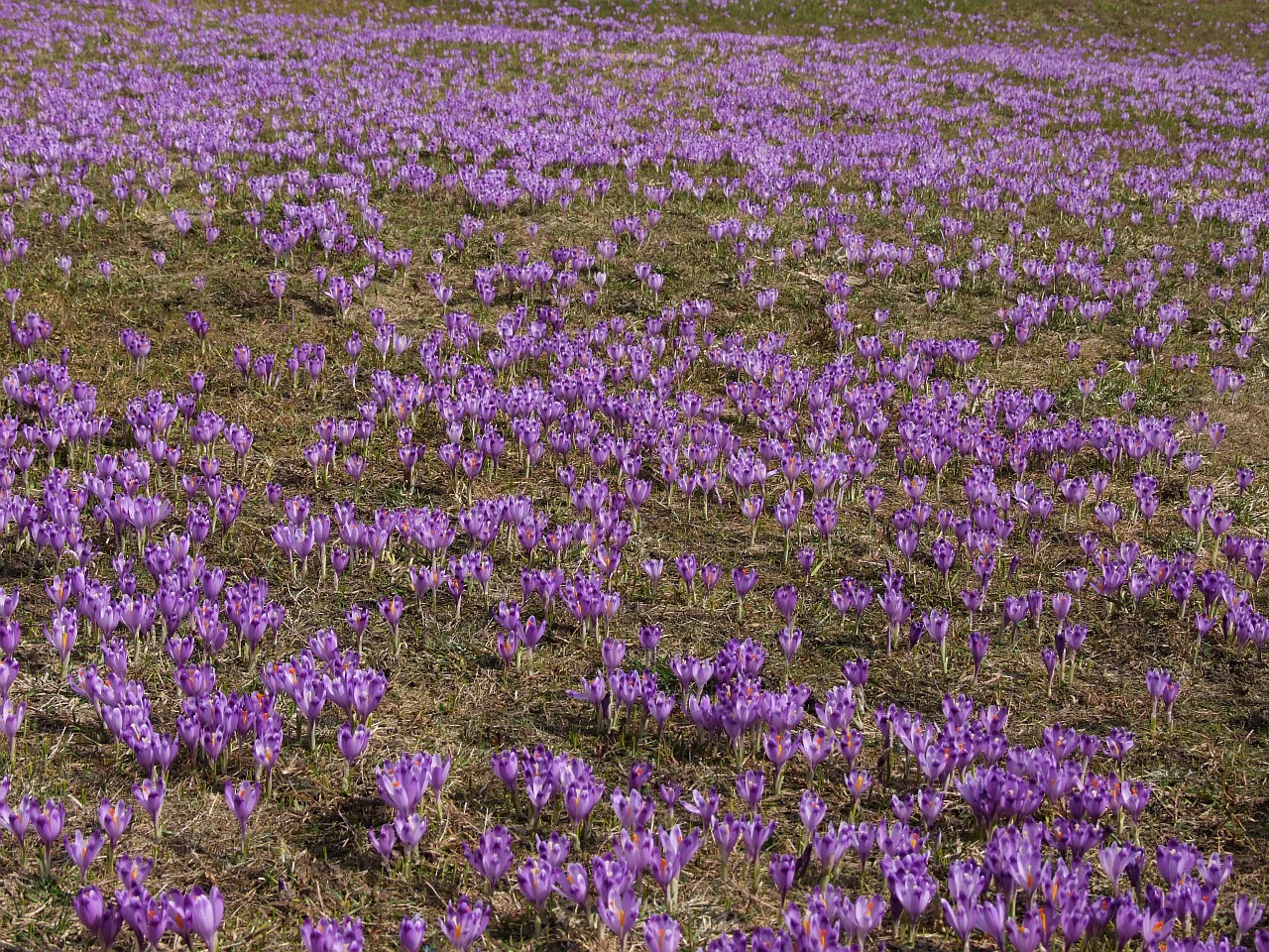
Gorce National Park is best known for its sweeping Carpathian panoramas from open mountain clearings, with Turbacz and neighboring summits acting as natural viewpoints toward the Tatras, Pieniny, and surrounding Beskid ranges. The park's grassy polany, or clearings, spring to life with flowering crocuses in early season and have become one of the most recognizable visual signatures of the park. Equally central to its identity is the extensive Carpathian forest, where old-growth beech, fir, and spruce stands thrive across two forest vegetation belts and shelter species such as brown bear, wolf, Eurasian lynx, black grouse, and capercaillie. The park is also recognized for combining high conservation value with a layered cultural landscape shaped by centuries of Wallachian-influenced pastoral traditions.
Gorce National Park history and protected-area timeline

The desire to protect the Gorce landscape predates the establishment of the national park by decades. As early as 1927, Ludwik Wodzicki, owner of extensive lands around Poręba Wielka, created a 114-hectare nature reserve named after the writer Władysław Orkan in recognition of the area's scenic and natural value.

Despite earlier conservation interest, the formal national park was not established until decades later. Created by a 1980 regulation of the Council of Ministers and officially designated in 1981, the park initially covered 5908 hectares. It was expanded in 1988 to 6763 hectares and has since grown further, with later documentation recording an area of roughly 7030 hectares. In 1997, a protective buffer zone of over 16,600 hectares was added around the park to strengthen its long-term ecological integrity.

The park's cultural roots run deeper still. The open clearings that visitors see today were shaped from the fourteenth century onward by pastoralists who migrated from the Balkan Peninsula and brought transhumance traditions with them. Their continued seasonal grazing maintained the open character of the hills, and even after the national park's creation, debates about how to preserve these clearings from reforestation have shaped the park's ongoing management philosophy. The first director and organizer of the park was Jerzy Honowski.

Gorce National Park landscape and geographic character

The landscape of Gorce National Park is defined by the typical rounded forms of the western Carpathians: long ridges, broad summit plateaus, and deep stream valleys rather than dramatic rocky spires. The park includes several of the range's most notable peaks, with Turbacz as the dominant massif, alongside Jaworzyna Kamienicka, Kiczora, Trzy Kopce, Kudłoń, Gorc, and Czoło Turbacza. From the higher points and especially from the open clearings, the panorama stretches across the Tatras, the Pieniny, and the Beskid Wyspowy and Beskid Sądecki ranges, giving the park some of the most expansive views in the Polish Carpathians.

Water plays a defining role in shaping the terrain. Mountain streams drain the slopes into the surrounding valleys, while small seepage areas known locally as młaki create wet depressions where unique vegetation thrives. The contrast between these wet pockets, rocky exposures, dense forest, and wide grassy clearings gives the park its layered visual identity. The clearings themselves, products of human activity, now feel like integral features of the landscape, particularly in spring when they bloom with crocuses.

Within the forested zones, the park contains treestands that are repeatedly described as well over a hundred years old, lending many parts of the range a near-primeval feel. The combination of mature canopy, fallen deadwood, and shaded gullies gives the lower montane forests a softer, more closed character, while the upper forests become more open and dominated by spruce, signaling the transition toward the subalpine style of the higher peaks.
Gorce National Park ecosystems, habitats, and plant life

Gorce National Park hosts one of the most botanically diverse forest landscapes in the Polish Carpathians. More than 900 vascular plant species have been recorded in the Gorce area, alongside hundreds of species of mosses, lichens, and liverworts, with a substantial share found within the park and its buffer zone. The flora includes alpine specialists, mountain forbs, and a remarkable concentration of legally protected taxa.

Forests cover around 95 percent of the park's area, and they form two distinct vegetation belts: a lower montane forest belt between roughly 650 and 1100 meters and an upper montane forest belt above that line. The lower belt is rich in mixed communities combining beech, fir, and spruce, while the upper belt becomes increasingly spruce-dominated. Notable forest communities include Carpathian beech forests, acidophilus beech forests, fertile fir forests, mixed spruce-fir forests typical of this elevation, and alder swamp variants in wetter areas.

The park's botanical richness is not limited to the forest. Wet depressions along the streams shelter rare herbaceous communities, and the open clearings host more than a hundred plant species that are tied directly to this maintained open habitat. These include orchids, crocuses, and various mountain-meadow plants whose continued presence depends on preserving the clearing ecosystem. The careful contrast between forest and meadow is one of the defining ecological themes of the park.
Gorce National Park wildlife and species highlights

The extensive forests and varied habitats of Gorce National Park support a rich vertebrate fauna, including all the large mammals typical of the Carpathian highlands. Wild boar, red deer, roe deer, European otter, European badger, and stoat are all present, joined in rarer roles by brown bear, gray wolf, and Eurasian lynx, alongside the European wildcat in more concealed habitats. The presence of these large predators and ungulates underscores the value of the park's connected forest ecosystems.

The park also records 185 vertebrate species, of which 21 appear on Poland's Red Data Book of Animals. Notable amphibians include the Carpathian newt, while birdlife is rich and varied: black grouse, white-backed woodpecker, three-toed woodpecker, capercaillie, lesser spotted eagle, golden eagle, Eurasian eagle-owl, Ural owl, Eurasian pygmy owl, and Eurasian pygmy-owl relatives such as the boreal owl are among the species of conservation concern documented here. About 130 bird species occur in the area, with roughly 100 breeding within the park itself, nine bat species are present, and seven amphibian species complete the broader vertebrate picture. The park's streams shelter two fish species, including brown trout.

Gorce National Park conservation status and protection priorities

Gorce National Park carries significant conservation weight within the Polish Carpathians. Its protected zone system distinguishes strict protection areas, where natural processes take precedence, from active protection areas and landscape-level protection zones where management interventions occur. This zoning approach reflects the need to preserve high-value forest habitats while maintaining the open clearings that are themselves key to local biodiversity.

The park hosts 21 vertebrate species listed in Poland's Red Data Book of Animals, along with 113 protected plant taxa, highlighting its role as a refuge for species that have lost habitat elsewhere in the region. Its invertebrate fauna is also notable, with more than 1000 documented species including 23 Carpathian or Carpathian-Sudeten endemics and roughly 100 species of mountain or boreal affinity. The diversity of species tied specifically to open clearings is particularly important, as these habitats have declined across much of Europe.

The buffer zone added around the park in 1997 strengthens these conservation gains by reducing pressures on the core area and supporting ecological connectivity with surrounding landscapes. Ongoing plans to expand the park's boundaries reflect continuing recognition of its conservation potential and the value of integrating additional forest areas into its protection framework.

Gorce National Park cultural meaning and human context

The Gorce mountains carry a deep pastoral cultural imprint that is visible in the park's landscape today. The open clearings that punctuate the forest were created beginning in the fourteenth century by settlers arriving from the Balkan Peninsula, who introduced transhumance practices and the seasonal use of high mountain meadows for grazing. Their techniques, later continued by local highlanders, shaped both the vegetation pattern and the cultural identity of the Gorce range.

At its peak, this pastoral activity made the Gorce second only to the Tatras as a center of highland grazing in the Polish mountains, with active shepherding and a network of wooden shepherd shelters dotting the clearings. The most intensive grazing period ended around the Second World War, and the subsequent abandonment of many clearings led to natural reforestation. The park has responded by reintroducing cultural grazing at selected sites and managing clearings through manual mowing in others, in an effort to preserve both the biodiversity and the cultural memory of these traditional mountain landscapes.

Top sights and standout views in Gorce National Park

The defining highlights of Gorce National Park are concentrated where the dense Carpathian forest gives way to wide, sweeping clearings high in the range. These polany shape the visual rhythm of the park and offer some of the most expansive views in southern Poland, looking out toward the Tatras, the Pieniny, and surrounding Beskid ranges.

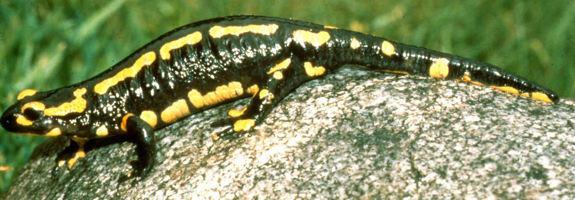
The park's natural diversity is a second major highlight. Old beech-fir-spruce forests stretch across most of the area, while seepage meadows, wetlands, and rocky pockets nurture rare plants and unique invertebrates. Large mammals, including brown bear, wolf, and Eurasian lynx, share these forests with rarer woodland birds such as capercaillie and black grouse. The fire salamander, as the park's symbol, anchors an identity tied to old, healthy forest and clean mountain streams.

A more subtle but equally meaningful highlight is the layered cultural landscape, where medieval pastoral traditions still echo in the maintained clearings and in the resurgence of cultural grazing at selected sites.

Best time to visit Gorce National Park

Late spring and early summer bring the high mountain clearings to life with carpets of crocuses and rich displays of mountain flora, while the fresh green of the surrounding forests and the wide visibility toward the Tatras make this period especially rewarding for landscape-oriented visits. Temperatures are generally mild, and trails through the forest are at their most photogenic in this season.

Late summer and early autumn offer a different character. The forests stabilize into deeper greens, and the clearings regain broader views as the weather becomes more reliable, with autumn colors bringing warm tones to the beech and fir stands. Winter transforms the park into a quieter, snow-covered landscape; while conditions can be more demanding for travel, the snow-blanketed clearings and forest edges have a particular stillness that complements the park's more contemplative identity.


Monthly climate preview

Measured monthly climate patterns and representative elevation statistics for Gorczański Park Narodowy

Gorczański Park Narodowy Climate Normals, Long-Term Temperature and Precipitation Rhythm

Representative coordinate records show average temperatures ranging from negative winter lows to warm summer maximums alongside varying monthly precipitation rates across the landscape. Examining the full twelve-month profile provides complete historical averages for detailed monthly comparison within Lesser Poland Voivodeship.
Annual mean6 °C
-5 °C17 °C
Jan-5°
Feb-4°
Mar
Apr
May11°
Jun15°
Jul17°
Aug17°
Sep12°
Oct
Nov
Dec-4°
Warmest month
July

16.7 °C

Coolest month
January

-4.9 °C

Wettest month
July

4.4 mm/day

Driest month
December

1.7 mm/day

Park location guide

Geography guide, regional context, and park location map for Gorce National Park

Gorce National Park park geography, regions, and map view in Poland

Understand where Gorce National Park sits in Poland through a broader geographic reading of the surrounding landscape, nearby location context, and its mapped position within the national park landscape.

How Gorce National Park fits into Poland

Poland, officially the Republic of Poland, is a Central European country spanning from the Baltic Sea in the north to the Carpathian Mountains in the south. It borders Germany, Czech Republic, Slovakia, Ukraine, Belarus, Lithuania, and Kaliningrad Oblast. The country has a temperate climate, diverse landscapes, and is known for its rich history, cultural heritage, and strong economic position within the EU.

Wider geography shaping Gorce National Park in Poland

Poland occupies 312,696 km2 in Central Europe, extending from the Baltic Sea coast in the north to the Sudetes and Carpathian Mountains in the south. It borders Germany to the west, Czech Republic and Slovakia to the south, Ukraine and Belarus to the east, and Lithuania and Kaliningrad Oblast to the northeast. The landscape includes lowland plains, uplands, and mountain ranges.

Map view of Gorce National Park

Use this park location map to pinpoint Gorce National Park in Poland, understand its exact geographic position, and read its mapped placement within the surrounding landscape more clearly.

Pigeon | © OpenStreetMap contributors

Location context for Gorce National Park

Lesser Poland Voivodeship
Natural feature types

Examine the Geographic Features and Natural Landmarks of Gorczański Park Narodowy

Explore the diverse topography and natural landforms associated with Gorczański Park Narodowy through our structured geographic index. MoriAtlas enables precise browsing of summits, clearings, and wetland habitats that constitute this protected Carpathian massif. Start mapping the physical landscape of this unique Polish natural area.
Recorded earthquake history

Examine the Earthquake History Catalogue for Gorczański Park Narodowy

Review the recorded seismic activity and historical earthquake data associated by proximity with Gorczański Park Narodowy. This structured dataset, powered by MoriAtlas, offers clear access to technical records for those exploring the geological context and seismic documentation of the region.

Gorczański Park Narodowy Earthquake History

Catalogued events

9 events

Strongest magnitude

Magnitude 4.8

Most recent event

Jun 25, 2006

This history includes earthquakes recorded inside the park or within 50 km of its borders

Park atlas

Compare adjacent Carpathian mountain reserves and regional protected areas

Parks Near Gorczański Park Narodowy and Surrounding Protected Landscapes

Browsing nearby national parks allows visitors to compare the dense beech forests and mountain clearings of Gorczański Park Narodowy with other protected landscapes across the region. Expanding the geographic scope reveals how surrounding Carpathian terrain and regional habitats connect across the broader mountain ecosystem.
Watercolor painting showing rolling green hills, forests, and distant mountains under a pale sky
National parkLesser Poland Voivodeship
Park boundaries overlap#1 closest

West

Gorce National Park: A Comprehensive Geographic Profile and Protected Area Analysis

Mountain meadows and Carpathian forest landscapes in southern Poland

Gorce National Park preserves an essential segment of the Western Beskids, offering a look into the region's arched ridges and forested terrain. The area serves as a critical protected landscape featuring significant biodiversity, ancient woodland, and open mountain meadows that distinguish the local geography of the Lesser Poland Voivodeship.

Area
70.3 km²
Established
1981
IUCN
II
Visitors
80K annual
Nature reserveLesser Poland Voivodeship
Park boundaries overlap#2 closest

East

Ostoja Gorczańska: Protected Area Mapping and Carpathian Mountain Geography in Lesser Poland

Ecological corridors across the Gorce and Beskid Wyspowy ranges

Covering nearly 18,000 hectares, Ostoja Gorczańska represents a significant biodiversity reservoir in the Polish Carpathians. The site integrates multiple protection frameworks, safeguarding varied habitats from subalpine grasslands to dense montane forests and peatland depressions. Use this resource to examine the structural connectivity of these mountain units and the expansive wilderness corridors found within the Lesser Poland Voivodeship.

Area
179.979 km²
Established
2008
Relief
Mountain
Climate
Temperate
Protected areaLesser Poland Voivodeship
2.7 km away#3 closest

Southeast

Środkowy Dunajec z dopływami: Protected River Habitats and Carpathian Foothills Geography

Exploring the river corridor and riparian ecosystems of southern Poland

Spanning 755 hectares across four connected enclaves, Środkowy Dunajec z dopływami protects the vital riverine systems of the middle Dunajec and its tributaries. This site offers a unique look at the fluvial processes and biodiversity of Carpathian mountain streams, showcasing diverse habitat structures from pioneer gravel banks to mature riparian forests.

Area
7.56 km²
Relief
Upland
Scope
Terrestrial
Water
Major water bodies
Nature reserveLesser Poland Voivodeship
6 km away#4 closest

Southwest

Torfowiska Orawsko-Nowotarskie Nature Reserve: Mapped Geography and Protected Bog Landscapes

A vital peatland complex within the Polish Carpathian foothills.

Torfowiska Orawsko-Nowotarskie stands as one of the most comprehensive peatland conservation sites in the Polish Carpathians. Its landscape is defined by dome-shaped raised bogs, marshy pools, and boggy woodlands that occupy the broad intermontane basin of the Kotlina Orawsko-Nowotarska, offering a unique look at post-glacial wetland ecology.

Area
82.667 km²
Established
2007
Relief
Upland
Climate
Temperate
Protected areaLesser Poland Voivodeship
7.1 km away#5 closest

Northwest

Raba z Mszanką Protected Area: Atlas of Carpathian Riverine and Riparian Landscapes

Geographic map and habitat overview for southern Poland.

Raba z Mszanką serves as a significant protected corridor within the Lesser Poland Voivodeship. The site illustrates the ecological gradient of mountain stream environments, featuring shifting gravel bars, willow shrublands, and floodplain forests. This entry provides context on the riverine geography, including its role in sustaining populations of the Mediterranean barbel within the Carpathian foothills.

Area
2.493 km²
Scope
Terrestrial
Water
Major water bodies
Nature reserveWojewództwo małopolskie
About 7.7 km away#6 closest

Northeast

Rezerwat przyrody Mogielica: Mapping Protected Forests and Summit Terrain in the Beskid Wyspowy

A vital Carpathian nature reserve and bird sanctuary

Located at the highest point of the Beskid Wyspowy, Rezerwat przyrody Mogielica is a significant protected area dedicated to forest conservation and the preservation of rare wildlife, including the capercaillie. This site showcases unique geological features around its rocky summit and preserves intact montane forest gradients that characterize the natural heritage of the Polish Carpathians.

Area
0.504 km²
Established
2011
Relief
Mountain
Climate
Temperate
Nature reserveLesser Poland Voivodeship
About 9.2 km away#7 closest

Southeast

Rezerwat przyrody Modrzewie: Mapping Protected Larch Woodland Geography in Lesser Poland

Nature reserve on the southern slopes of the Gorce mountains

The Rezerwat przyrody Modrzewie nature reserve protects a rare stand of old-growth larch trees within the Gorce mountain range. Located on the southern slopes of Lubań in the Lesser Poland Voivodeship, this site provides valuable data on Carpathian forest ecology, displaying distinct tree populations that contrast with the surrounding alpine meadows and montane landscapes of southern Poland.

Area
0.107 km²
Established
1959
Relief
Mountain
Climate
Temperate
Nature reserveLesser Poland Voivodeship
9.6 km away#8 closest

North

Łąki koło Kasiny Wielkiej: Protected Meadow Habitats in Lesser Poland Voivodeship

Ecological mapping of traditional Carpathian grassland ecosystems.

Łąki koło Kasiny Wielkiej is a specialized nature reserve in the Beskid Wyspowy range, protecting fragmented semi-natural meadows that represent essential habitat types within the European Natura 2000 network. By analyzing the site boundaries and regional landscape context within Lesser Poland Voivodeship, this entry provides insight into how low-intensity farming preserves distinctive grassland flora and terrain structure in the Carpathian foothills.

Area
0.244 km²
Established
2011
Relief
Mountain
Climate
Temperate

Common questions about visiting, size, designation, and location context for Gorce National Park

Gorce National Park FAQs for park facts, access, geography, and protected area context

Find quick answers about Gorce National Park, including protected-area facts, park geography, trail and visitor context, and how the park fits into its surrounding country and regional landscape.
MoriAtlas Explorer

Continue Your Protected Areas Search Across the Global Atlas

Deepen your exploration by continuing the structured search for national parks and protected areas worldwide. Utilize the comprehensive filtering capabilities to compare different conservation landscapes and refine your understanding of global park geography. Discover more about the distribution and characteristics of protected natural areas.

Global natural geography