
Mori Atlas logo
Nature reserveGras-Ellenbacher Wiesen

Examining the valley basin geography, seepage spring horizons, and wet meadow ecosystems of this Hessian nature reserve.

Gras-Ellenbacher Wiesen Nature Reserve: Mapped Protected Landscapes in the Sandstone Odenwald

(Naturschutzgebiet Gras-Ellenbacher Wiesen)

Gras-Ellenbacher Wiesen is a protected nature reserve nestled within a shallow valley basin of the sandstone Odenwald in southern Hesse. This atlas entry details the site's 24 hectares of managed grassland, drainage ditches, and seepage spring horizons. The protected area serves as a vital ecological transition between the forested Dachsberg and Kirchberg ridges and the open valley floor, preserving a traditional mosaic of moist habitats and wet meadow terrain.

wet meadownature reserveseepage springssmall sedge communitiesOdenwaldsandstone upland
A flat-style digital illustration of a green, rolling valley with a dirt path winding through the foreground toward a small village near a waterfall and forested mountains.

Gras-Ellenbacher Wiesen

Nature reserve

Park overview

Structured park overview, official facts, and landscape profile for Gras-Ellenbacher Wiesen

Gras-Ellenbacher Wiesen park facts, protected area profile, and essential visitor context

Review the core facts for Gras-Ellenbacher Wiesen, including designation, size, terrain, visitor scale, habitats, and operating context in one park-focused overview.

About Gras-Ellenbacher Wiesen

Gras-Ellenbacher Wiesen is a compact nature reserve set within the sandstone Odenwald of southern Hesse, in the Bergstraße district of central Germany. It occupies a shallow basin northeast of the village of Gras-Ellenbach, where the Ulfenbach stream gathers seepage water from the surrounding meadows. The reserve covers only about 24 hectares, yet within that small footprint it preserves a layered mosaic of grassland, wetland, and arable habitats that are otherwise rare in the region.

The site is defined by its valley setting. To the east, the forested slopes of the Dachsberg (around 482 meters) and Kirchberg (around 493 meters) close in toward the meadows, while the western side opens toward a state road and the edges of Grasellenbach itself. A sports field sits at the forest edge, marking the transition from settlement to protected landscape. Beyond the strict reserve boundary, additional meadow areas and a parallel landscape protection area (Landschaftsschutzgebiet) extend the ecological and visual character of the site outward.

Ecologically, the reserve is dominated by extensive wet meadows, fallow wet ground, and small springs and ditches. These moist habitats are the core reason for protection, sustaining populations of threatened plant and animal species that depend on persistent water seepage and traditional low-intensity grassland use. The protection ordinance specifies extensive meadow management and the preservation of small sedge communities (Kleinseggenriede), ensuring that the reserve remains actively managed rather than passively preserved.

As part of the Geo-Naturpark Bergstraße-Odenwald, Gras-Ellenbacher Wiesen contributes to a broader regional network of geological, ecological, and cultural heritage sites. Its small scale makes it less visually dramatic than larger German national parks, but its ecological concentration, traditional character, and clean integration into the Odenwald landscape make it a meaningful representative of the area's intact valley meadow heritage.

Quick facts and research context for Gras-Ellenbacher Wiesen

Gras-Ellenbacher Wiesen is a Naturschutzgebiet (nature reserve) in the Bergstraße district of southern Hesse, Germany, located in the Odenwald near the community of Grasellenbach. It was placed under formal nature protection in 1994 (marking its current designation cycle) and carries the official identifier 1431023 within the Hessian protected-area system. Although German sources reference an earlier protective status date in 1981, the reserve is administratively recorded as a small-scale grassland and wetland protection area of about 24 hectares.

The reserve lies within the natural region known as the Wegscheidekamm in the sandstone Odenwald, an area characterized by forested ridges and shallow valley basins. It is also part of the Geo-Naturpark Bergstraße-Odenwald, a UNESCO Global Geopark that connects geological, ecological, and cultural heritage across the region. Its IUCN category is IV, indicating a habitat and species management area.

Protection and recognition

Terrestrial protected area documentation, scope, and conservation status

Gras-Ellenbacher Wiesen Protection Status and Official Designation Record

Gras-Ellenbacher Wiesen features documented terrestrial protection status within global conservation databases. Official records outline the registered management scope and environmental framework associated with the protected landscape.

Protection details

Protection scope
Terrestrial
WDPA ID
163302
Park context

Deeper park guide and search-rich context for Gras-Ellenbacher Wiesen

Gras-Ellenbacher Wiesen history, landscape, wildlife, and travel context

Explore Gras-Ellenbacher Wiesen through its history, landscape character, ecosystems, wildlife, conservation priorities, cultural context, and seasonal travel timing in a structured park guide built for atlas discovery and search intent.

Why Gras-Ellenbacher Wiesen stands out

The reserve is best known for its extensive wet meadows and seepage spring habitats set in a small Odenwald valley basin. The combination of managed grassland, fallow wet ground, drainage ditches, and natural spring horizons creates a mosaic of moist habitats that support numerous threatened plant and animal species. It is also notable as a landscape-level example of how traditional extensive meadow management is used to maintain species-rich wet grassland in a low-intensity, small-scale German setting. The protected status of the area explicitly combines habitat conservation with the preservation of local landscape beauty, reflecting an integrated approach typical of well-established Hessian Naturschutzgebiete.
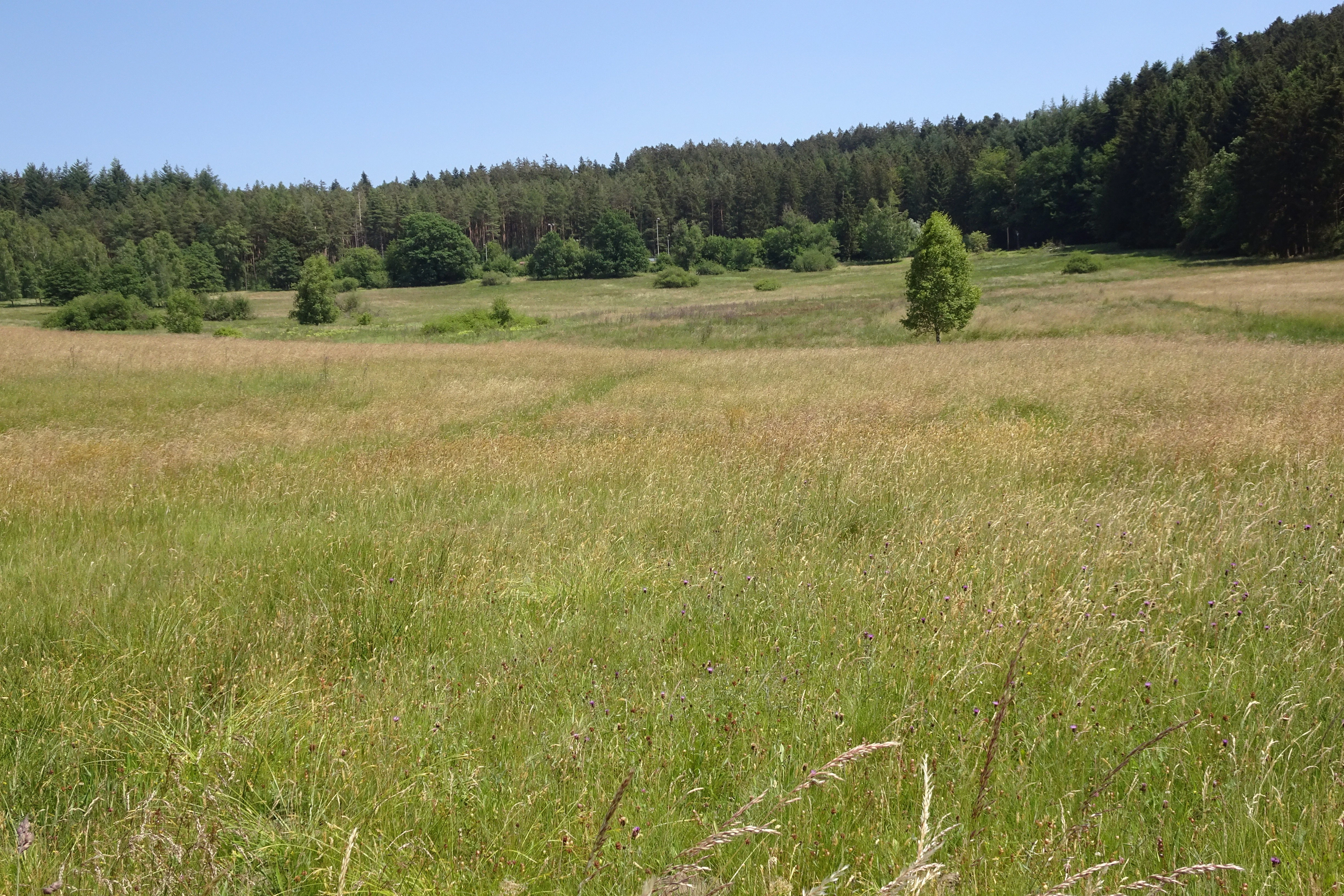
A wide, grassy meadow stretches toward a dense forest line under a clear blue sky.
A view of the open wet meadows at Gras-Ellenbacher Wiesen in the Odenwald region.

Gras-Ellenbacher Wiesen history and protected-area timeline

The area now protected as Gras-Ellenbacher Wiesen received its formal nature protection status as a Naturschutzgebiet under Hessian law in the early 1990s, with the protection ordinance process culminating in a December 1994 administrative establishment. German sources also reference an earlier protective designation date associated with the 1981 planning effort under the identifier 1431023, indicating that the site's conservation history stretches back through several decades of regional protection administration.

Throughout this period, the reserve has been managed primarily to maintain its traditional meadow character, with protection provisions specifying extensive grassland use and the preservation of small sedge wetland communities. This management continuity reflects a long-standing regional commitment to preserving valley-bottom wet habitats in the Odenwald, where small-scale farming and small-scale grassland protection have coexisted for generations.

Gras-Ellenbacher Wiesen landscape and geographic character

The landscape of Gras-Ellenbacher Wiesen is shaped by a shallow valley basin within the sandstone Odenwald. The reserve sits in a softly sloping hollow framed on the east by the forested Dachsberg and Kirchberg ridges, whose summits reach roughly 482 and 493 meters in elevation. The combination of forested slopes above and open meadow below creates the classic Odenwald transition between dense woodland and managed valley grassland.

The terrain within the protected area itself is gently undulating rather than dramatic, dominated by meadows, fallow wet ground, and edges of small arable fields. The Ulfenbach stream flows through the reserve, originating from a pond near a sawmill northwest of the main meadows and gathering seepage water from the surrounding wet ground. Ditches and natural spring horizons weave through the grassland, adding small-scale hydrological structure to what would otherwise be a uniform meadow plain.

West of the reserve, the landscape opens further toward the state road L 3105 and the outskirts of Grasellenbach, where additional meadow areas and a companion landscape protection area continue the visual and ecological character of the site. The result is a layered, transitional landscape: from hilltop forest to valley meadow, from protected reserve to broader protected countryside, and from natural spring seepage to managed farmland edge.
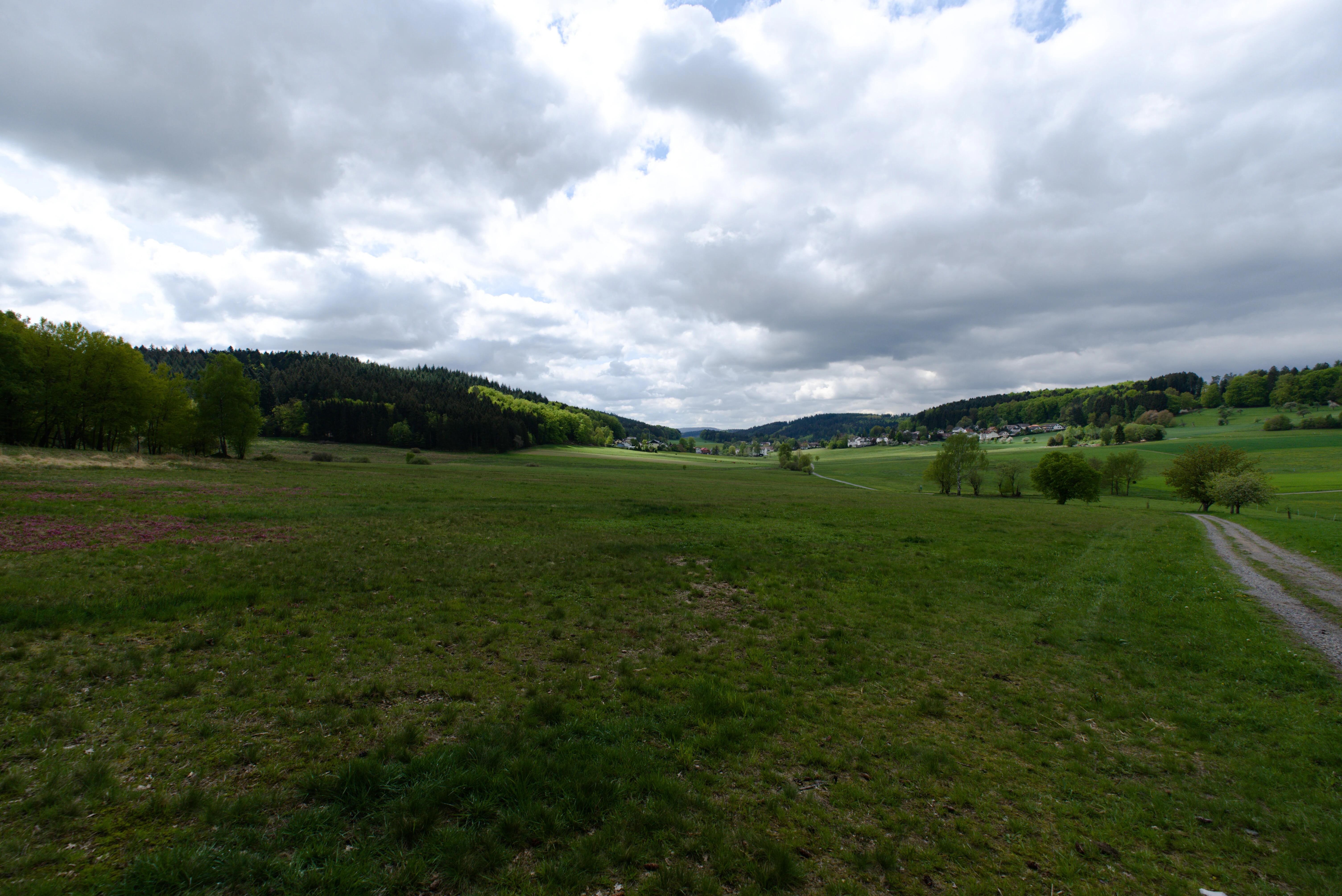
A wide landscape view of green meadows at Gras-Ellenbacher Wiesen in Germany under a cloudy sky, with a small trail on the right and forested hills in the distance.
A view of the meadows at Gras-Ellenbacher Wiesen, looking towards the village.

Gras-Ellenbacher Wiesen ecosystems, habitats, and plant life

Gras-Ellenbacher Wiesen preserves a concentrated ecological mosaic within the sandstone Odenwald, centered on wet meadow and seepage habitat types that are otherwise scarce in the broader region. The reserve's vegetation is dominated by managed grassland and fallow wet ground, interspersed with small arable patches that reflect the site's agricultural heritage. The wet meadows are interspersed with ditches, small streams, and natural spring horizons, creating a connected network of moist microhabitats.

A particular conservation emphasis is placed on small sedge communities (Kleinseggenriede), a characteristic wet habitat type of spring-influenced valley grasslands. These communities depend on a delicate balance of seepage flow, mowing regime, and low nutrient input, all of which are explicitly addressed in the reserve's protection ordinance. The combination of meadow, fallow ground, wet ditches, and spring seepage creates the habitat complexity required to support a diverse, often specialized, plant and animal community in an otherwise modest area.

Although the reserve is small, the ecological intensity of its habitats gives it a significance that exceeds its footprint. Each habitat element, from the wet meadow edge to the upper spring horizon, contributes to a functioning lowland valley ecosystem typical of the sandstone Odenwald.

Gras-Ellenbacher Wiesen wildlife and species highlights

The reserve is described as habitat for numerous threatened plant and animal species, with the wet meadows, ditches, and spring seepage supporting the bulk of this biodiversity. Its mosaic of managed grassland, wet ground, and small arable patches creates a layered habitat structure where specialized species can find refuge within an intensively used regional landscape.

Moisture-dependent fauna benefits particularly from the seepage zones and slow-flowing ditches of the Ulfenbach valley bottom, while the surrounding meadow structure provides nesting and foraging cover for typical grassland-associated species. The combination of small-scale habitat diversity and traditional management continuity makes the reserve a stable refuge for species that would otherwise be marginalized by more intensified land use outside its boundaries.

Gras-Ellenbacher Wiesen conservation status and protection priorities

Gras-Ellenbacher Wiesen is classified as a Habitat/Species Management Area under the IUCN system (Category IV), reflecting its role as a site actively managed to conserve specific habitats and species rather than preserved as a strict wilderness area. Its designation as a Naturschutzgebiet under Hessian law gives it formal protection status and commits it to a defined management regime.

Conservation priorities at the site focus on preserving the wet meadows, seepage springs, and small sedge communities that define its ecological value. The protection ordinance specifies extensive meadow management, allowing traditional low-intensity use to continue while preventing changes that would degrade the moisture-dependent habitats. This combination of habitat protection and continued cultural landscape use is characteristic of Hessian grassland reserves.

Beyond its borders, the reserve sits within the Geo-Naturpark Bergstraße-Odenwald, a UNESCO Global Geopark that links geological, ecological, and cultural heritage across the region. Its inclusion in this network strengthens its profile as a regionally recognized conservation area, even though nationally it remains a small, locally important site within the broader network of Bergstraße district nature reserves.

Gras-Ellenbacher Wiesen cultural meaning and human context

The reserve reflects the cultural landscape tradition of the Odenwald, where small valley meadows have been managed continuously for hay production and low-intensity grazing over many generations. The combination of meadow, village edge, and forested hill in the reserve's setting is a classic configuration of the southern Hessian sandstone uplands, and the protection ordinance explicitly recognizes the scenic value of the area alongside its ecological value.

This integration of cultural landscape and conservation is central to the reserve's identity. Rather than removing human use, the protected status is designed to preserve the traditional relationship between the local community and its valley-bottom grasslands, ensuring that the cultural landscape character of the Grasellenbach area remains recognizable even as ecological management takes precedence.

Top sights and standout views in Gras-Ellenbacher Wiesen

A concentrated 24-hectare wet meadow reserve with seepage springs, drainage ditches, and small sedge communities at its core. The site combines traditional extensive meadow management with formal nature protection, exemplifying how small Hessian grassland reserves integrate cultural landscape preservation and habitat conservation.

Located in the sandstone Odenwald near Grasellenbach, the reserve lies within the UNESCO Global Geopark Bergstraße-Odenwald and forms part of the broader network of Naturschutzgebiete in the Bergstraße district. Its valley basin setting, framed by the Dachsberg and Kirchberg hills and crossed by the Ulfenbach, gives it a clear and recognizable Odenwald geography that complements its ecological significance.

Best time to visit Gras-Ellenbacher Wiesen

As a meadow and wetland reserve at moderate Odenwald elevations, Gras-Ellenbacher Wiesen is best appreciated in late spring and summer, when the grasslands are in active growth and traditional mowing typically takes place. The combination of green meadow color, full ditches, and visible spring seepage tends to make the site's hydrological character most apparent during these seasons.

Outside the growing season, autumn can also offer a quieter experience with fewer visitors, while winter visits reveal the structural character of the Odenwald valley but offer limited visibility of the meadow flora. Because the reserve is a working protected landscape rather than a visitor attraction, access at any time should prioritize staying on visible paths and respecting ongoing management activity.

Monthly climate preview

Monthly temperature ranges and precipitation averages recorded at a representative coordinate

Gras-Ellenbacher Wiesen Climate Normals and Measured Annual Temperature Patterns

Long-term NASA measurements establish the baseline temperature progression and precipitation rhythm across twelve months at Gras-Ellenbacher Wiesen. Examining the complete climate profile reveals detailed monthly fluctuations in average maximums, minimums, and daily precipitation.
Annual mean10 °C
0 °C20 °C
Jan
Feb
Mar
Apr
May14°
Jun18°
Jul20°
Aug20°
Sep15°
Oct10°
Nov
Dec
Warmest month
July

20.3 °C

Coolest month
January

0.1 °C

Wettest month
July

2.4 mm/day

Driest month
April

1.5 mm/day

Park location guide

Geography guide, regional context, and park location map for Gras-Ellenbacher Wiesen

Gras-Ellenbacher Wiesen park geography, regions, and map view in Germany

Understand where Gras-Ellenbacher Wiesen sits in Germany through a broader geographic reading of the surrounding landscape, nearby location context, and its mapped position within the national park landscape.

How Gras-Ellenbacher Wiesen fits into Germany

Germany is a federal republic in Western and Central Europe with a population of over 83 million across sixteen constituent states. It is Europe's largest economy by nominal GDP and a major global exporter and importer. The capital is Berlin, and the country borders Denmark, Poland, Czech Republic, Austria, Switzerland, France, Luxembourg, Belgium, and the Netherlands.

Wider geography shaping Gras-Ellenbacher Wiesen in Germany

Germany is located in Western and Central Europe, spanning 357,022 km². It borders Denmark to the north, Poland and the Czech Republic to the east, Austria and Switzerland to the south, and France, Luxembourg, Belgium, and the Netherlands to the west. The country has coastlines on the Baltic Sea and North Sea to the north, with the Alps located in the southern region.

Map view of Gras-Ellenbacher Wiesen

Use this park location map to pinpoint Gras-Ellenbacher Wiesen in Germany, understand its exact geographic position, and read its mapped placement within the surrounding landscape more clearly.

Pigeon | © OpenStreetMap contributors

Location context for Gras-Ellenbacher Wiesen

Hesse

Visual exploration of wet meadows, valley basins, and protected Odenwald habitats

Gras-Ellenbacher Wiesen Photos and Landscape Scenery

Visual records illustrate the extensive wet meadows, seepage spring horizons, and valley basin terrain that characterize the protected landscape. Photographic documentation reveals the traditional grassland management and transitional forest edges defining the regional ecosystem.

A wide, grassy meadow stretches toward a dense forest line under a clear blue sky.

A wide landscape view of grassy meadows and rolling hills in a rural region, with scattered trees and a dirt path on the right side.

A wide landscape view of green meadows at Gras-Ellenbacher Wiesen in Germany under a cloudy sky, with a small trail on the right and forested hills in the distance.

Park atlas

Compare regional valley basins and connected Odenwald conservation landscapes

Explore Other Parks Near Gras-Ellenbacher Wiesen And Surrounding Protected Areas

Discover nearby national parks and protected areas sharing the distinctive sandstone upland geography of southern Hesse. Browsing adjacent reserves reveals broader regional meadow habitats and connected valley terrain.
A wide watercolor painting showing rolling green hills and trees with pale pink and yellow hues across a valley landscape.
Nature reserveHessen
About 3.3 km away#1 closest

South

Rotes Wasser von Olfen Nature Reserve: Protected Wetland and Odenwald Geography

A unique bog and iron-rich stream landscape in Hessen, Germany.

Rotes Wasser von Olfen preserves a rare, small-scale mosaic of transitional bog and wet meadow vegetation within the Odenwald range. This protected site features reddish, iron-rich seepage waters and provides essential habitat for specialized flora and dragonfly populations amidst a surrounding forested mountain landscape.

Area
0.121 km²
Established
1980
IUCN
IV
Relief
Upland
Watercolor painting of soft, rolling green hills and meadows in a minimalist style, set against a light background.
Nature reserveHessen
About 8.1 km away#2 closest

South

Dürr-Ellenbachtal von Wald-Michelbach: Odenwald Nature Reserve and Protected Valley Geography

A historic meadow valley in Hessen, Germany

The Dürr-Ellenbachtal von Wald-Michelbach nature reserve protects an elongated, narrow valley framed by forested ridges in the central Odenwald. This area is defined by its meandering brook, diverse alder stands, and species-rich meadows that sustain significant local biodiversity. As a key Natura 2000 site, it serves as an essential example of protected meadow landscapes and rural mountain terrain within the Bergstraße district.

Area
0.542 km²
Established
1990
IUCN
IV
Relief
Mountain
A wide watercolor illustration showing a river curving through a grassy valley with trees and hills in the background.
Nature reserveHessen
About 9.2 km away#3 closest

Southwest

In der Erbach bei Mörlenbach Nature Reserve: Protected Odenwald Stream Valley

Regional geography and habitat mapping in southern Hessen

The In der Erbach bei Mörlenbach nature reserve preserves a well-defined side-valley ecosystem within the broader Odenwald landscape. Its protected boundaries encompass a moisture-rich corridor featuring wet meadows, reedbeds, and forest edges that exemplify the traditional cultural geography of the Weschnitz river basin in southern Germany.

Area
0.197 km²
Established
1997
IUCN
IV
Relief
Upland
Watercolor painting of a green wetland landscape with a winding stream and distant hills in soft pastel colors.
Nature reserveHesse
About 9.4 km away#4 closest

West

Albersbacher Riedwiesen Nature Reserve: Mapped Geography and Protected Landscapes in Hesse

A detailed atlas view of the Albersbach stream valley conservation corridor.

Situated in the Weschnitz valley region of Hesse, the Albersbacher Riedwiesen nature reserve offers a concentrated look at traditional Odenwald landscapes. The area protects a unique combination of wet meadows, reedbeds, and dry grasslands that follow the natural meandering course of the Albersbach stream, providing a vital study in local geomorphology and conservation geography.

Area
0.124 km²
Established
1996
Nature reserveHesse
About 9.7 km away#5 closest

Northeast

Rohrsee von Rehbach Nature Reserve: Protected Wetland Atlas and Regional Geography

Wetland ecosystems in the sandstone Odenwald region of Hesse

Examine the geography of Rohrsee von Rehbach, an IUCN category protected area in southern Hesse. The site features a man-made pond and significant reed habitats that offer a rare wetland contrast to the surrounding sandstone terrain. Our atlas details the reserve's topography, hydrologic features, and its function as a managed refuge for waterbirds in the Odenwald landscape.

Area
0.156 km²
Established
1986
IUCN
IV
Nature reserveHesse
About 11 km away#6 closest

Southwest

In der Striet bei Vöckelsbach Nature Reserve: Regional Geography and Mapped Protected Landscapes

A compact forest and wetland mosaic in the Odenwald of southern Hesse

The nature reserve In der Striet bei Vöckelsbach is an essential protected area covering four and a half hectares of valley floor. It provides a dense habitat gradient from reeded spring zones through alder forests to mixed deciduous slopes. This record details the park landscape, stream systems, and its integration into the larger Geo Naturpark Bergstraße Odenwald and Natura 2000 protected areas.

Area
0.048 km²
Established
1988
A horizontal watercolor illustration of a soft green landscape with meadows, scattered trees, and distant rolling hills under a pale pink sky.
Nature reserveHessen
About 12 km away#7 closest

Northwest

Schannenbacher Moor Nature Reserve: Geographic Overview and Protected Area Boundaries

Wetland and forest mosaic in the southern Hessian Odenwald

Schannenbacher Moor represents a significant protected area within Hessen, characterized by its combination of raised bog remnants, reedbeds, and near-natural floodplain woodlands. Framed by the Krehberg slopes and the Meerbach stream system, the reserve offers a rare example of low mountain bog ecology and biodiversity conservation. This mapped landscape provides essential data on the distribution of mire plant communities and bryophyte habitats in the region.

Area
0.162 km²
Established
1975
IUCN
IV
Watercolor painting of a gentle, rolling green landscape with sparse trees and distant hills on a white background.
Nature reserveHesse
About 12 km away#8 closest

Southeast

Jakobsgrund bei Gammelsbach Nature Reserve: Geographic Atlas and Park Boundary Mapping

Protected sandstone valley landscapes in southern Hesse

This nature reserve in the Odenwald hills provides a concentrated example of traditional valley land use. The area features a sharp contrast between dry south-facing slopes and damp, stream-carved lowlands, creating a botanical hotspot within the regional geography of Hesse, Germany.

Area
0.095 km²
Established
1996
IUCN
IV
Relief
Upland

Common questions about visiting, size, designation, and location context for Gras-Ellenbacher Wiesen

Gras-Ellenbacher Wiesen FAQs for park facts, access, geography, and protected area context

Find quick answers about Gras-Ellenbacher Wiesen, including protected-area facts, park geography, trail and visitor context, and how the park fits into its surrounding country and regional landscape.
MoriAtlas Explorer

Continue Your Protected Areas Search Across the Global Atlas

Deepen your exploration by continuing the structured search for national parks and protected areas worldwide. Utilize the comprehensive filtering capabilities to compare different conservation landscapes and refine your understanding of global park geography. Discover more about the distribution and characteristics of protected natural areas.

Global natural geography