
Mori Atlas logo
Nature reserveGriesheimer Bruch

Understanding the geography, wetland mosaic, and protected boundaries of this southern Hesse nature reserve

Griesheimer Bruch Nature Reserve: Mapped Protected Landscapes in the Hessian Rhine Plain

(Naturschutzgebiet Griesheimer Bruch)

Griesheimer Bruch is a protected nature reserve in the Darmstadt-Dieburg district of Hessen, preserving fragments of a former lowland bog ecosystem within the Hessian Upper Rhine Plain. This area provides an essential refuge for wetland species through a mosaic of wet meadows, alder carr forest, and managed amphibian habitats. Explore the mapped geographic features of this protected land, its integration into the wider Natura 2000 network, and its ecological connection to neighboring wetlands in the Rhine-Main region.

wetlandlowland bognature reservenaturschutzgebietNatura 2000EU bird protection area
A flat-style digital illustration showing a path splitting into two directions in a forest setting with green trees and grassy foreground.

Griesheimer Bruch

Nature reserve

Park overview

Structured park overview, official facts, and landscape profile for Griesheimer Bruch

Griesheimer Bruch park facts, protected area profile, and essential visitor context

Review the core facts for Griesheimer Bruch, including designation, size, terrain, visitor scale, habitats, and operating context in one park-focused overview.

About Griesheimer Bruch

Griesheimer Bruch is a compact but ecologically rich nature reserve in the southern part of the German state of Hesse, lying on the western outskirts of the town of Griesheim in the Darmstadt-Dieburg district. Positioned within the Hessian Upper Rhine Plain, it forms a small green pocket of wetland habitat in a region otherwise dominated by settlements, agriculture, and infrastructure. The reserve occupies about 35 hectares of mixed woodland, wet meadows, fallow ground, and open water, and protects the surviving remnants of what was once a larger lowland bog landscape.

Formally protected since 7 February 2000, the area has gradually been integrated into broader European conservation frameworks. Since 2007, it has been part of the EU Bird Protection Area known as the Hessische Altneckarschlingen, giving the local site an additional layer of recognition for its value to breeding and migrating birds. At the international level, the reserve is registered in the World Database on Protected Areas (WDPA 318462) and is formally designated under the Natura 2000 code DE6217403.

From an ecological perspective, Griesheimer Bruch is unusual for combining several rare or declining habitat types in one place. Its substrate features high-standing, base-rich groundwater that historically supported a near-pure black alder and grey willow carr forest (Alnetea glutinosae), while its surface now showcases mat-grass swards on silicate soils and small purple moor-grass meadows on calcareous, peaty and clayey-silty ground. Together these habitats support a diverse mix of moisture-loving plants, amphibians, and breeding waterbirds, making the reserve a locally important stepping stone for wetland biodiversity in the Rhine-Main lowlands.

Quick facts and research context for Griesheimer Bruch

Griesheimer Bruch is a small nature reserve located west of Griesheim in the Darmstadt-Dieburg district of Hesse, Germany, within the natural region of the Hessian Upper Rhine Plain. The reserve covers approximately 35 hectares and combines wetland, meadow, and woodland habitats. It was officially designated as a Naturschutzgebiet on 7 February 2000 and was incorporated into the EU Bird Protection Area 'Hessische Altneckarschlingen' in 2007. It carries the WDPA identifier 318462 and the Natura 2000 site code DE6217403, classifying it as an IUCN Category IV habitat and species management area.

Protection and recognition

Examine the verified conservation standing and administrative tracking records

Griesheimer Bruch Protection Status and Official Designation Records

Griesheimer Bruch brings together documented protection status, management scope, and official designation records from verified conservation databases. Structured tracking details provide reliable context regarding the protected area designation and associated administrative records.

Protection details

WDPA ID
318462
Park context

Deeper park guide and search-rich context for Griesheimer Bruch

Griesheimer Bruch history, landscape, wildlife, and travel context

Explore Griesheimer Bruch through its history, landscape character, ecosystems, wildlife, conservation priorities, cultural context, and seasonal travel timing in a structured park guide built for atlas discovery and search intent.

Why Griesheimer Bruch stands out

Griesheimer Bruch is best known as a refuge for remnants of a former lowland bog (Niedermoor) ecosystem within one of Germany's most intensively used lowland regions. Its character is defined by species-rich mat-grass swards (Borstgrasweide), purple moor-grass meadows (Molinion caeruleae), and a partially surviving alder carr forest of black alder and grey willow. The reserve is also notable for its amphibian-friendly wetland features, including wet meadows, ditches, fish ponds, and a purpose-built amphibian pool, which together support common frogs, toads, newts, and visiting white storks.
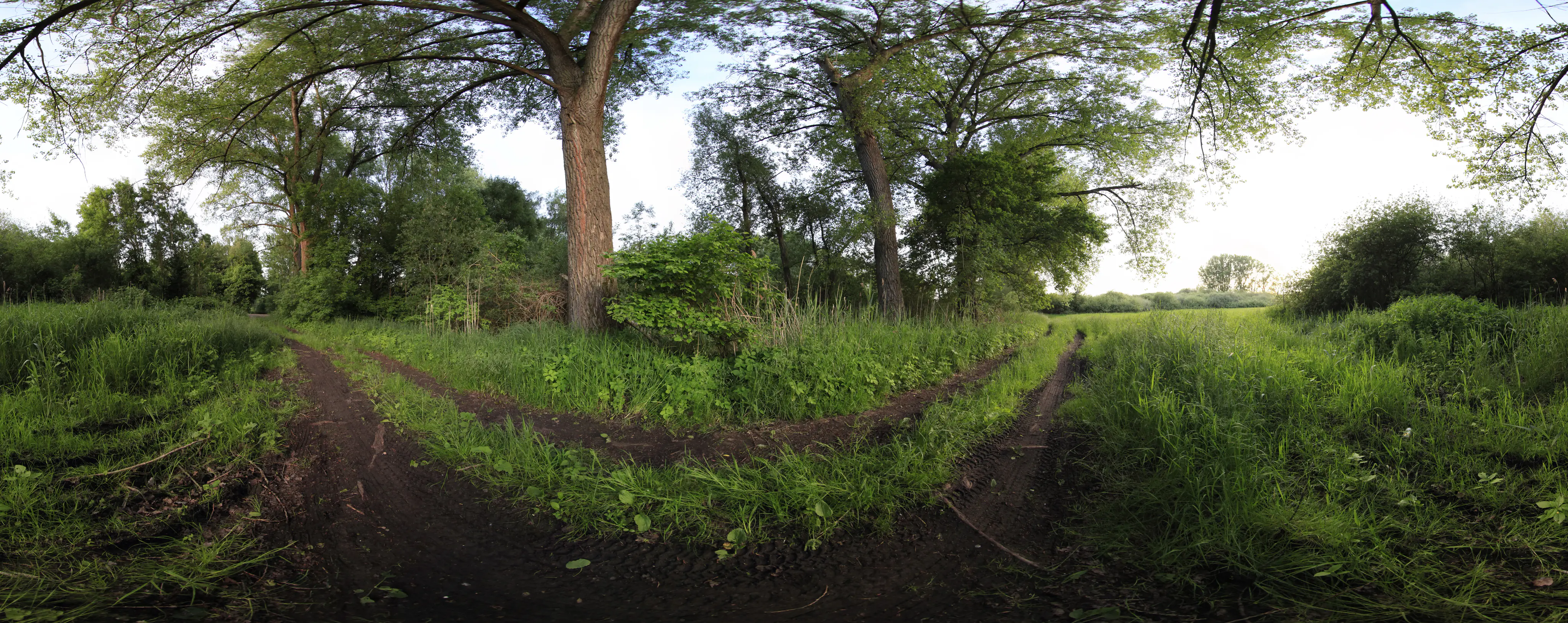
A 360-degree panoramic view of a dirt walking path passing through tall green grass and mature trees in a natural setting.
A wide-angle view of a muddy trail winding through the green, lush landscape of Griesheimer Bruch.

Griesheimer Bruch history and protected-area timeline

The legal foundation of the modern Griesheimer Bruch reserve dates to 7 February 2000, when the area was formally designated as a Naturschutzgebiet (nature reserve) under Hessian conservation law. Since then it has been managed with the explicit goal of preserving the relict wetland habitats that survived in this part of the Upper Rhine Plain.

In 2007 the reserve was also recognized as part of the larger EU Bird Protection Area 'Hessische Altneckarschlingen,' embedding the local site within the European Natura 2000 network. Conservation efforts in the reserve have focused on gradually raising groundwater levels and encouraging extensive use of the remaining grassland in order to maintain the value of the wet meadows, fallow areas, and shrub groups. In 2015 a dedicated amphibian pool was created within the reserve to further improve conditions for native amphibian species.

The name itself has older roots: the German word 'Bruch,' derived from Old High German and Middle High German 'bruoch,' refers to marshy or boggy ground, and the historical form 'Das Griesheimer Bruch' reflects this long-standing association with wet meadows and damp terrain.

Griesheimer Bruch landscape and geographic character

Griesheimer Bruch sits at ground level within the flat Hessian Upper Rhine Plain, a lowland setting where subtle differences in groundwater and soil chemistry shape the character of the landscape rather than dramatic topography. The reserve is essentially a mosaic of damp woodland, wet meadows, shrub groups, and open ditches, crisscrossed by field and forest paths. To the west it borders the adjacent nature reserve Torfkaute–Bannholz von Dornheim-Wolfskehlen, strengthening its landscape continuity.

The underlying hydrology is central to the site's character. High-standing, base-rich groundwater moves slowly beneath the reserve, and in spring, before the growing season begins, the area can experience flooding and prolonged waterlogging. The thick peat layer beneath the historical carr forest consists largely of wood and cone fragments that have largely lost recognizable plant structure. Surface drainage through a network of ditches, combined with several fish ponds and a purpose-built amphibian pool, gives the landscape its mix of open water, wet meadow, and damp woodland patches.

At the northwest margin of the reserve stands the listed historic Hohe Brücke (High Bridge), a cultural landmark that marks the transition between the protected wetland and the surrounding countryside.

Griesheimer Bruch ecosystems, habitats, and plant life

The reserve is an unusual concentration of declining lowland wetland habitats within a heavily used agricultural and suburban region. Its core ecological identity rests on a former black alder and grey willow carr forest, surviving patches of mat-grass swards on silicate soil, and small purple moor-grass meadows on calcareous peaty soils. Surface vegetation includes grasses and herbs typical of damp grasslands, while the ground layer on the deeper peat reflects centuries of slowly accumulating organic material.

Today the area no longer functions as a pure alder carr. Instead it resembles a partially drained mixed woodland interspersed with forest meadows (Waldwiesen). A network of ditches, several fish ponds, and a constructed amphibian pool add open-water habitats that are crucial for amphibians and for overall habitat diversity. Historically the site was likely a near-pure Alnetea glutinosae community, but groundwater drawdown has shifted the balance toward dry-tolerant species and altered the original forest structure.

Griesheimer Bruch wildlife and species highlights

Wildlife in Griesheimer Bruch is shaped strongly by the site's wet meadows, ditches, ponds, and damp woodland. Amphibians are a particular focus of the reserve. Native frogs, toads, and newts inhabit the wet meadows and ditches, while rarer species such as the common frog (Grasfrosch), the garlic toad (Knoblauchkröte), and the natterjack toad (Kreuzkröte) appear locally, although they have not yet established permanent populations. The 2015 construction of an amphibian pool reflects active efforts to create the shallow, sun-warmed open waters that these species require for long-term breeding success.

The reserve also provides nesting habitat for white storks (Weißstorch), which return to the area to breed each year. This birdlife presence contributed to the inclusion of Griesheimer Bruch within the larger EU Bird Protection Area Hessische Altneckarschlingen. The combination of water bodies, damp meadows, shrub thickets, and woodland edges supports a broader community of wetland-associated invertebrates and small fauna, even though the site's partial drainage limits how much of the original wetland fauna can persist.

Griesheimer Bruch conservation status and protection priorities

Conservation is the central purpose of Griesheimer Bruch. The reserve's designation in 2000 was aimed specifically at preserving the relict lowland bog habitats, including wet meadows, fallow ground, and shrub groups, that remained in the western part of Griesheim. The protection goal is to secure these wet biotopes as habitat for rare and endangered plant and animal species, while gradually raising the groundwater levels and encouraging extensive grassland management.

Over time, the site has gained additional protection through its incorporation into the EU Bird Protection Area Hessische Altneckarschlingen in 2007 and through its formal listing as a Natura 2000 site (DE6217403). Internationally it is recognized as an IUCN Category IV habitat and species management area and is recorded in the World Database on Protected Areas under ID 318462. Management interventions, such as the 2015 amphibian pool, demonstrate an ongoing effort to restore habitat function despite the partial drainage that still affects parts of the reserve.

Griesheimer Bruch cultural meaning and human context

The main cultural reference associated with Griesheimer Bruch is linguistic rather than architectural. The word 'Bruch,' from Old High German and Middle High German 'bruoch,' refers to marshy, boggy ground, and so the place name itself encodes the landscape's identity as wet meadow and damp lowland. The historical form 'Das Griesheimer Bruch' preserves this older naming tradition.

On the northwestern edge of the reserve stands the listed Hohe Brücke (High Bridge) at Griesheim, a heritage-protected structure that points to longer human engagement with this corner of the Rhine plain. Beyond these elements, the reserve is best understood as a small, locally meaningful patch of traditional wetland landscape that has been retained within a region otherwise shaped by modern settlement and agriculture.

Top sights and standout views in Griesheimer Bruch

Griesheimer Bruch stands out for packing several rare lowland wetland features into a compact 35-hectare reserve. Highlights include surviving mat-grass swards on silicate soil, small purple moor-grass meadows on calcareous peat, and remnants of a black alder and grey willow carr forest over thick peat deposits shaped by base-rich groundwater. The reserve's mix of ditches, fish ponds, forest meadows, and a dedicated amphibian pool supports a notable amphibian community and provides breeding habitat for white storks.

Its position within the wider Natura 2000 network, as part of the EU Bird Protection Area Hessische Altneckarschlingen, gives the reserve value beyond its local scale and reinforces its role as a refugium for wetland biodiversity in the southern Hessian Rhine plain.

Best time to visit Griesheimer Bruch

The reserve's character shifts visibly with the seasons in ways that reflect its wetland identity. In early spring, before the main growing season, the area can experience flooding and prolonged saturation, which highlights the site as a working floodplain landscape and offers strong conditions for observing amphibians and wetland birds. Late spring and early summer tend to bring out the grassland communities, including the mat-grass swards and purple moor-grass meadows, while summer evenings offer the most accessible walking conditions along the field and forest paths crossing the reserve. Autumn and winter bring quieter conditions and a different atmospheric palette over the partially drained mixed woodland and wet meadows.

Monthly climate preview

Long-term monthly temperature and precipitation patterns across representative coordinate points

Griesheimer Bruch Climate Normals, Annual Temperature and Precipitation Rhythm

Griesheimer Bruch exhibits a measured annual temperature and precipitation rhythm spanning long-term averages from NASA data. Detailed monthly breakdowns provide deeper insight into temperature ranges and precipitation variations across the protected terrain.
Annual mean10 °C
0 °C21 °C
Jan
Feb
Mar
Apr10°
May14°
Jun18°
Jul21°
Aug20°
Sep15°
Oct10°
Nov
Dec
Warmest month
July

20.6 °C

Coolest month
January

0.2 °C

Wettest month
July

2.2 mm/day

Driest month
April

1.4 mm/day

Park location guide

Geography guide, regional context, and park location map for Griesheimer Bruch

Griesheimer Bruch park geography, regions, and map view in Germany

Understand where Griesheimer Bruch sits in Germany through a broader geographic reading of the surrounding landscape, nearby location context, and its mapped position within the national park landscape.

How Griesheimer Bruch fits into Germany

Germany is a federal republic in Western and Central Europe with a population of over 83 million across sixteen constituent states. It is Europe's largest economy by nominal GDP and a major global exporter and importer. The capital is Berlin, and the country borders Denmark, Poland, Czech Republic, Austria, Switzerland, France, Luxembourg, Belgium, and the Netherlands.

Wider geography shaping Griesheimer Bruch in Germany

Germany is located in Western and Central Europe, spanning 357,022 km². It borders Denmark to the north, Poland and the Czech Republic to the east, Austria and Switzerland to the south, and France, Luxembourg, Belgium, and the Netherlands to the west. The country has coastlines on the Baltic Sea and North Sea to the north, with the Alps located in the southern region.

Map view of Griesheimer Bruch

Use this park location map to pinpoint Griesheimer Bruch in Germany, understand its exact geographic position, and read its mapped placement within the surrounding landscape more clearly.

Pigeon | © OpenStreetMap contributors

Location context for Griesheimer Bruch

Hessen

Explore detailed imagery of wet meadows, alder carr woodland, and protected wetland habitats.

Griesheimer Bruch Photos and Landscapes: Visualizing the Lowland Bog Environment

Visual documentation captures the flat terrain and intricate hydrology of the reserve across changing seasons. Studying these habitat views helps reveal the ecological character of the protected lowland bog landscape.

A 360-degree panoramic view of a dirt walking path passing through tall green grass and mature trees in a natural setting.

A nature reserve triangular sign on a post stands in a green field next to a dirt path, with trees and bushes in the background.

Park atlas

Compare adjacent wetland reserves and regional conservation areas in southern Hesse

Parks Near Griesheimer Bruch and Surrounding Protected Landscapes

Browse protected areas near Griesheimer Bruch to examine similar lowland bog habitats and wetland ecosystems across the Upper Rhine Plain. Extending conservation research through neighboring nature reserves reveals broader regional patterns in floodplain hydrology and specialized wildlife refuges.
Soft watercolor illustration of a calm, marshy wetland scene with reeds, a lone bare tree on the left, and a soft forest line in the background.
Nature reserveHessen
About 4.2 km away#1 closest

Northeast

Löserbecken von Weiterstadt Nature Reserve in Hessen: A Detailed Geographic Overview

Protected landscape within the Upper Rhine Plain

Löserbecken von Weiterstadt protects a distinct basin landscape characterized by the interaction between former sand extraction slopes and naturally forming rainwater wetlands. This reserve showcases the transformation of post-industrial ground into a high-value habitat for crested newts and other species. Explore the boundaries and topographic features of this compact, protected Hessen nature area.

Area
0.08 km²
Established
1983
IUCN
IV
A horizontal watercolor painting depicting a soft, rolling meadow with patches of trees and distant hills.
Nature reserveHessen
About 4.7 km away#2 closest

Northwest

Bruchwiesen bei Büttelborn Nature Reserve: Hessen Protected Wetland and River Meander

Mapped terrain and protected fen ecology in the Rhine Main region

Bruchwiesen bei Büttelborn represents a major protected lowland fen situated along a former course of the Neckar River. The site provides a mosaic of reedbeds, moist grasslands, and deciduous woodlands, creating a crucial habitat within the agricultural landscape of Hessen. This data highlights the park boundaries and the complex hydrological features that define this ecologically significant wetland.

Area
0.88 km²
Established
1997
IUCN
IV
A soft watercolor painting of a winding river flowing through a lush green floodplain with distant hills under a pale sky.
Nature reserveHessen
About 5.1 km away#3 closest

Southwest

Kühkopf-Knoblochsaue Nature Reserve: A Detailed Look at Hessian Rhine Floodplain Geography

Protected river island terrain, alluvial forests, and floodplain dynamics

Examine the geographic characteristics of Kühkopf-Knoblochsaue, the premier nature reserve in the Hessian Ried. This site provides an in-depth atlas perspective on the Rhine floodplain, featuring the iconic inland island structure, softwood and hardwood forest transitions, and the ongoing influence of the Stockstadt-Erfelder Altrhein on the local terrain.

Area
24.4 km²
Established
1952
Relief
Lowland
Climate
Temperate
Nature reserveHessen
About 7.4 km away#4 closest

North

Am Belzberg Nature Reserve: A Detailed Atlas of Protected Sand Grassland Landscapes

Protected natural areas and regional terrain in Hessen, Germany

Explore the specialized geography of Am Belzberg, a nature reserve nestled in the Untermainebene region of Hessen. This protected area represents an essential habitat for dry-substrate plant communities and local fauna, serving as a key example of small-scale conservation management in the lower Main river plain.

Area
0.053 km²
Established
1996
IUCN
IV
A horizontal watercolor painting depicting a calm lake with grassy banks, reeds, and a soft, hazy treeline in the background against a pale sky.
Nature reserveHessen
About 8.8 km away#5 closest

East

Bessunger Kiesgrube Nature Reserve: A Detailed Look at the Hessen Protected Landscape

Examining post-industrial geography and forest recovery

The Bessunger Kiesgrube is a designated nature reserve located in Hessen, Germany. Once a centuries-old gravel extraction site, the area now features a groundwater-fed lake bordered by steep rocky banks and dense, naturally regenerated woodland. This site provides a clear case study of ecological recovery on the edge of urban development, offering insight into the geological and environmental legacy of the region.

Area
0.118 km²
Established
1978
Relief
Lowland
Climate
Temperate
A pale, soft watercolor landscape painting of a quiet lake with shoreline reeds, trees in the background, and branches framing the scene on the sides.
Nature reserveHesse
About 9.4 km away#6 closest

Northeast

Am Kleewoog von Gräfenhausen Nature Reserve: Geography and Protected Area Landscape Overview

A regional sanctuary of sand habitats and former gravel pits in Hesse

Examine the distinct ecological geography of Am Kleewoog von Gräfenhausen. This reserve showcases the transition between rugged, water-filled gravel excavations and stable pine-oak forest stands on acidic inland dunes. Gain insight into the regional importance of this protected mosaic as an amphibian refuge and a remnant of the unique geological substrate found across the Darmstadt sand sheet.

Area
0.209 km²
Established
1985
IUCN
IV
Relief
Lowland
A pale, soft-toned watercolor painting showing rolling green and golden dunes under a light, hazy sky.
Nature reserveHessen
About 9.5 km away#7 closest

Southeast

Düne am Ulvenberg von Darmstadt-Eberstadt: Inland Sand Dune Protected Area Geography

A rare Pleistocene dune ecosystem in the Hessen region.

Düne am Ulvenberg von Darmstadt-Eberstadt represents a critical inland dune fragment within the Upper Rhine Graben. This nature reserve provides essential habitat for sand-dwelling flora in a setting defined by its open, dry sandy flats, pine woodland, and specialized steppe-like turf that persists as a unique geological legacy.

Area
0.089 km²
Established
1991
IUCN
IV
Nature reserveHessen
About 10 km away#8 closest

North

Niederwald von Groß-Gerau Nature Reserve: Hessen Protected Woodland and Riparian Geography

A preserved lowland forest habitat in the Rhine-Main landscape

Niederwald von Groß-Gerau serves as a protected refuge for moist deciduous woodland in the Untermainebene. This nature reserve features an intricate network of streams and deadwood habitats, standing as a vital ecological link within the heavily developed region of Hessen. Explore the mapped boundaries and natural terrain of this unique, habitat-rich forest fragment.

Area
0.696 km²
Established
1995
IUCN
IV
Relief
Lowland

Common questions about visiting, size, designation, and location context for Griesheimer Bruch

Griesheimer Bruch FAQs for park facts, access, geography, and protected area context

Find quick answers about Griesheimer Bruch, including protected-area facts, park geography, trail and visitor context, and how the park fits into its surrounding country and regional landscape.
MoriAtlas Explorer

Continue Your Protected Areas Search Across the Global Atlas

Deepen your exploration by continuing the structured search for national parks and protected areas worldwide. Utilize the comprehensive filtering capabilities to compare different conservation landscapes and refine your understanding of global park geography. Discover more about the distribution and characteristics of protected natural areas.

Global natural geography