
Mori Atlas logo
Nature reserveHaff Réimech

A mosaic of reclaimed gravel pits and reedbeds in the Schengen border region

Haff Réimech Nature Reserve: Mapped Protected Wetlands and Moselle Valley Geography

(Naturschutzgebitt Haff Réimech)

Haff Réimech represents a significant protected wetland landscape situated along the Moselle river in southeastern Luxembourg. Spanning nearly one hundred hectares, this nature reserve features a complex network of shallow lakes and ponds formed from former industrial gravel extraction sites. The area provides critical habitat for diverse avian populations, serving as an important node within European wetland networks and providing unique insights into the transformation of industrial terrain into restored alluvial ecosystems.

wetland reserveformer gravel pitsbird sanctuaryRamsar siteNatura 2000 areaMoselle valley
A stylized vector-style illustration of a green valley framed by steep, blocky mountain cliffs with a waterfall cascading down one side and a dense coniferous forest in the foreground.

Haff Réimech

Nature reserve

Park overview

Structured park overview, official facts, and landscape profile for Haff Réimech

Haff Réimech park facts, protected area profile, and essential visitor context

Review the core facts for Haff Réimech, including designation, size, terrain, visitor scale, habitats, and operating context in one park-focused overview.

About Haff Réimech

Haff Réimech is a wetland nature reserve in the southeastern corner of Luxembourg, lying in the lower Moselle valley within the commune of Schengen. The site sits where the borders of Luxembourg, Germany, and France converge, close to the villages of Remerschen, Wintrange, and Schengen. Geographically, it occupies the broad, flat floor of the Moselle valley between the river on one side and the steep, vineyard-clad slopes of the Luxembourg Moselle wine region on the other.

The character of the reserve is shaped by its unusual origin. The land was originally floodplain of the Moselle, where regular flooding deposited layers of sand, gravel, and other sediments over the centuries. Archaeological finds show that the fertile soils here were already appreciated in Roman times. From the 1940s onward, the sandy-gravel mixtures of the Moselle floodplain were extracted on an industrial scale for construction use. Extraction left behind a landscape of deep basins, around forty of which gradually filled with water fed largely by underground springs originating in the vineyards above.

Following the canalization of the Moselle in the 1960s and the construction of the main Moselle road, the area finally lost direct contact with the river, but the former gravel pit landscape was already beginning its transformation into ecologically rich habitat. The combination of clean, spring-fed water, varied shoreline profiles, and nutrient-poor sandy soils produced a surprisingly diverse mosaic of open water, shallow shorelines, reedbeds, and small wooded patches. This mosaic now supports an exceptional range of birdlife, amphibians, reptiles, insects, and rare plant communities, including orchids on the drier sandy fringes of the reserve.

Quick facts and research context for Haff Réimech

Haff Réimech is a protected wetland in the commune of Schengen, in the triple-border area where Luxembourg meets Germany and France. It lies on the floor of the broad lower Moselle valley, west of the river and below the steep slopes of the Luxembourg wine region.

The reserve was formally established by Grand-Ducal regulation on 23 March 1998 and is classified as a zone of national interest. Its core and buffer zones together cover about 100 hectares. It is recognized internationally as a Ramsar wetland site and is also designated as an Important Bird Area under the European Union Birds Directive, forming part of the Natura 2000 network.

Protection and recognition

Documented protection history, terrestrial scope, and international designations

Haff Réimech Protection Status and International Recognition Data

Terrestrial protection records for Haff Réimech trace back to 1998 alongside official designations including Natura 2000 and Ramsar listings. Structured records detail international recognition sources and management frameworks established for the protected landscape.

International recognition

Protection details

Protection scope
Terrestrial
Designated year
1998
Transboundary protection
No
Core area
0.75 km²
Buffer area
0.26 km²
Park context

Deeper park guide and search-rich context for Haff Réimech

Haff Réimech history, landscape, wildlife, and travel context

Explore Haff Réimech through its history, landscape character, ecosystems, wildlife, conservation priorities, cultural context, and seasonal travel timing in a structured park guide built for atlas discovery and search intent.

Why Haff Réimech stands out

Haff Réimech is best known for its concentration of former gravel pit lakes that have been reclaimed by nature to form one of Luxembourg's most important wetland bird habitats. The site is nationally and internationally valued for its breeding, migratory, and wintering bird populations, and for the unusual way in which a heavily altered industrial landscape has reverted into ecologically rich habitat. It is also notable for being one of the few Luxembourg sites where several rare bird species, such as the little bittern and the tufted duck, still regularly breed, and where typical floodplain vegetation like extensive reedbeds has re-established itself on land that was once stripped of soil.
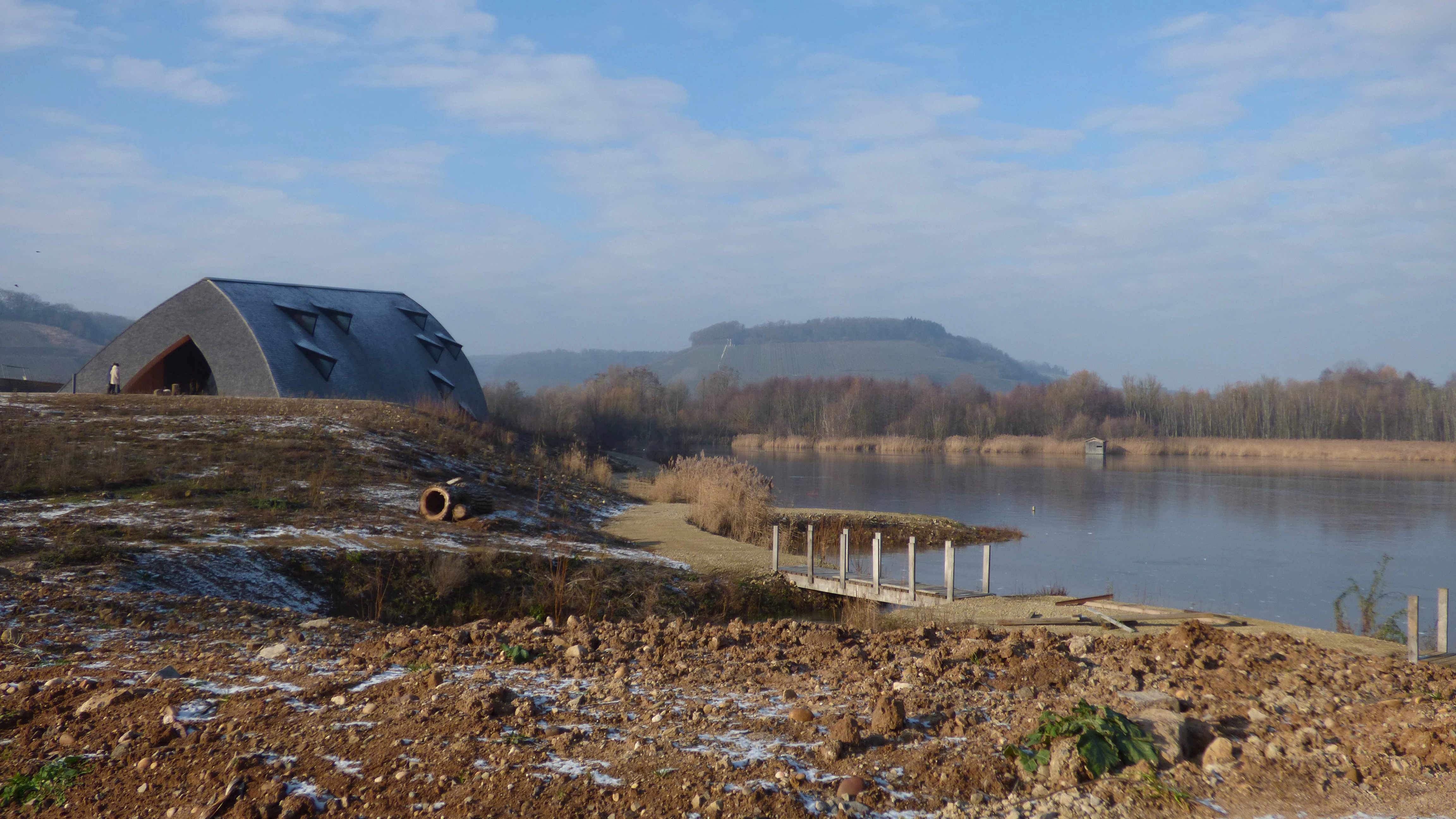
A modern curved structure stands on a grassy bank next to a calm lake, with hills in the background on a bright winter day.
A winter view of the Haff Réimech nature reserve, featuring the visitor center and pond.

Haff Réimech history and protected-area timeline

The land of Haff Réimech has a long history shaped by the Moselle. Regular flooding of the river over many centuries deposited successive layers of sand, gravel, and other sediments across the valley floor, gradually building up a fertile floodplain. Archaeological objects recovered from the area indicate that this productive land was already valued and used during the Roman period.

During the twentieth century, the landscape was transformed by industry. Beginning in the 1940s, the sand and gravel deposits of the Moselle valley were extracted at industrial scale to supply construction materials. Extraction left behind a network of deep pits, and once operations ceased in individual locations, these basins naturally filled with groundwater to form what is now a chain of about forty ponds and lakes.

Two further developments in the 1960s altered the wider setting of the site: the canalization of the Moselle and the construction of the main Moselle road. With these changes, the area lost its direct hydrological connection with the river, but the abandoned gravel pits had already begun their ecological transformation into wetlands. After long discussion, the site was finally given formal protection through a Grand-Ducal regulation of 23 March 1998, which declared the Haff Réimech wetland a protected zone of national interest. It includes the two nature reserves of Baggerweieren and Taupeschwues and comprises a core zone of roughly 75 hectares with a buffer zone of about 26 hectares. Today the site is also recognized as part of the international Ramsar network of important wetlands and is integrated into the European Natura 2000 network as an Important Bird Area under the EU Birds Directive.

Haff Réimech landscape and geographic character

Haff Réimech lies on the flat floor of the lower Moselle valley, in a section where the river valley widens noticeably north of the Stromberg hill near Schengen. To the east runs the Moselle itself, and to the west rise the steep slopes of the Luxembourg wine region, almost entirely covered in vineyards. Between these two landmarks stretches a broad alluvial plain that forms the setting of the reserve.

Within this plain, the most distinctive visual feature of the landscape is the series of former gravel extraction pits, of which roughly forty are counted within the reserve. These deeply cut basins, with their often vertical sandy or gravelly walls, contrast sharply with the surrounding flatter terrain. Over time, many of the steeper shorelines have been deliberately flattened to create gentle shallow-water zones, while others have been left more rugged. Some basins still expose bare sand and gravel flats, and a small artificial gravel island has been created as part of habitat management.

Between and around the water bodies, the landscape includes extensive reedbeds dominated by common reed, patches of riparian woodland along a small river-delta woodland zone, dry sandy and gravelly areas with low herbaceous vegetation, and a few banks where sand has been washed into low flats. The overall impression is of a deliberately varied, mosaic-like wetland landscape framed by the river and the vineyard slopes, rather than a uniform natural lake or marsh.

Haff Réimech ecosystems, habitats, and plant life

The ecological richness of Haff Réimech arises from the unusual combination of very clean, spring-fed groundwater, nutrient-poor sandy substrates, and a wide variety of shoreline types within a relatively compact area. Where sand and gravel pits were abandoned, sunken basins naturally filled with water from underground sources flowing out of the vineyards above, producing a network of about forty ponds with excellent water quality.

The reserve encompasses several distinct but interconnected habitats. Open water with deeper basins is interspersed with shallow-water zones created by flattening former pit walls, allowing light to reach the bottom and stimulating rich aquatic vegetation. Extensive reedbeds have developed around much of the shoreline, becoming one of the most characteristic features of the site. Drier sandy and gravelly areas with low herbaceous vegetation surround the reserve margins, and small patches of softwood floodplain woodland occupy parts of a small river-delta area, providing nesting habitat for less common bird species.

Although the landscape has been strongly shaped by human activity, this very disturbance has produced the mosaic of bare ground, open water, shallow margins, and reedbed that supports the reserve's exceptional biodiversity. The dynamics of regeneration after extraction are themselves an ecological feature of the site, and ongoing management, including vegetation clearing on the artificial gravel island and modification of shoreline profiles, continues to influence how habitats evolve.

Haff Réimech wildlife and species highlights

Haff Réimech is above all a bird reserve of national and international importance. Around 230 bird species have been recorded within the reserve, of which approximately 90 are breeding species. The site functions as a breeding area, a stopover for migrating birds, and a wintering refuge for waterbirds.

Among breeding species, the reserve was one of the first sites in Luxembourg where the little ringed plover and the sand martin nested, and several rare species rely heavily on the site. The great crested grebe, the little bittern, and the tufted duck all still breed in Luxembourg essentially only in this area. Large reedbeds around the ponds support further breeding species such as the great reed warbler and the bearded reedling, while the small river-delta woodland is notable for hosting nesting penduline tits with their characteristic hanging nests. Sand martins and kingfishers have historically nested in the steep walls of the old pits, though rapid overgrowth and erosion of sand banks have reduced nesting opportunities, and a gravel island has been created to maintain suitable habitat for ground-nesting species like the little ringed plover.

In winter, the ponds attract cormorants and bitterns, and the open water and surrounding shallow margins provide important refuge for waterfowl during cold periods. Shallow sand banks also serve as resting sites for waders during migration.

Beyond birds, the reserve is ecologically rich in other groups. In spring, frogs, toads, and newts use the warm, vegetation-rich shallow water for spawning, and the surrounding meadows and ponds host grass snakes, lizards such as the sand lizard which basks on open sandy and gravelly areas, and a notable dragonfly fauna. Drier, herb-rich margins of the reserve support rare wild orchid populations, which in turn attract a variety of butterflies and moths. Specialist studies have also documented rich communities of wild bees, wasps, water beetles, and other insects associated with the former gravel pit habitats.

Haff Réimech conservation status and protection priorities

Haff Réimech is recognized as one of the most ecologically valuable wetlands in Luxembourg, and conservation interest in the site extends well beyond the national level. It was formally designated as a protected zone of national interest by Grand-Ducal regulation on 23 March 1998, combining the two constituent nature reserves of Baggerweieren and Taupeschwues into a single protected area under a clear regulatory framework.

Internationally, the reserve is part of the Ramsar Convention's worldwide network of wetlands of international importance, reflecting its significance for migratory and wintering waterbirds as well as for the wetland habitats themselves. It is also an Important Bird Area under the European Union Birds Directive (Directive 79/409/EEC) and is integrated into the Natura 2000 network, meaning that its conservation status is formally recognized within European nature protection policy.

At a local level, conservation management focuses on maintaining and enhancing the mosaic of habitats that emerged after gravel extraction ended. Activities include flattening of selected former pit walls to create shallow-water zones, maintenance and clearing of vegetation on a small artificial gravel island to preserve bare-ground nesting habitat for species like the little ringed plover, and protection of reed margins and softwood floodplain patches. The site is also notable as an example of how a heavily disturbed industrial landscape, once abandoned, can be transformed into a high-value nature reserve through a combination of natural regeneration and targeted management.

Haff Réimech cultural meaning and human context

The floodplain that forms Haff Réimech has carried human meaning for a very long time. Archaeological discoveries of Roman-era objects in the area indicate that the fertile Moselle alluvial soils were valued and used during the Roman period, long before any modern industrial activity.

The surrounding region retains a strong cultural identity based on the Moselle wine trade. The western slopes bordering the reserve are almost entirely covered in vineyards, and the springs that rise through those vineyards feed the reserve's clean groundwater. Nearby communities, including Remerschen, Wintrange, and Schengen, are part of a wine-producing landscape that shapes local agriculture, architecture, and traditions, and the village of Schengen itself has become internationally recognizable through the Schengen Agreement.

The transformation of former gravel pits into a nature reserve is itself part of the broader cultural and environmental story of the Luxembourg Moselle, illustrating a shift in the regional economy away from heavy extraction and toward tourism, wine production, and nature-based recreation.

Top sights and standout views in Haff Réimech

Haff Réimech stands out as one of Luxembourg's most important wetland reserves, set in the unusually wide lower section of the Moselle valley where Luxembourg meets Germany and France. Its defining feature is a chain of around forty former gravel pit ponds fed by vineyard springs, which together support a mosaic of open water, shallow shoreline, reedbed, sandy dry ground, and small floodplain woodland.

The reserve is recognized internationally as a Ramsar wetland and European Natura 2000 site, and is perhaps best known for its birdlife, with around 230 recorded species including rare national breeders such as little bittern and tufted duck, and strong populations of migratory and wintering waterbirds. It is also notable as an example of how an industrial extraction landscape can revert into ecologically rich habitat, with ongoing management of an artificial gravel island, flattened shorelines, and protected reed margins to maintain that diversity.

Best time to visit Haff Réimech

As a wetland bird reserve, Haff Réimech changes its character meaningfully through the seasons, and different periods reward different interests. Spring is one of the most rewarding times to visit, when the reserve hosts breeding birds such as great reed warblers, bearded reedlings, and kingfishers, and when amphibians such as frogs, toads, and newts use the shallow warm water for spawning.

Late summer and autumn bring migratory waders and waterfowl to rest and feed on the shallow sand banks, open water, and reed edges. In winter, the ponds serve as an important refuge for waterbirds including cormorants and bitterns, and the surrounding bare sandy areas can also make wildlife easier to observe from the reserve's viewpoints and observation tower. The marked trails, relatively flat terrain, and viewpoints mean that the site can generally be explored across most of the year, with the strongest birdlife displays typically associated with spring and the migration seasons.

Monthly climate preview

Examining long-term temperature ranges and precipitation averages across the protected landscape

Haff Réimech Climate Normals and Annual Weather Patterns by Month

Representative coordinate measurements record monthly mean temperatures ranging from near freezing to warm summer highs alongside steady daily precipitation amounts throughout the year. Reviewing the complete twelve-month climatology profile provides deeper insight into long-term environmental conditions across the protected terrain.
Annual mean9 °C
0 °C19 °C
Jan
Feb
Mar
Apr
May13°
Jun17°
Jul19°
Aug19°
Sep14°
Oct
Nov
Dec
Warmest month
July

19.1 °C

Coolest month
January

0.4 °C

Wettest month
December

2.7 mm/day

Driest month
April

1.6 mm/day

Park location guide

Geography guide, regional context, and park location map for Haff Réimech

Haff Réimech park geography, regions, and map view in Luxembourg

Understand where Haff Réimech sits in Luxembourg through a broader geographic reading of the surrounding landscape, nearby location context, and its mapped position within the national park landscape.

How Haff Réimech fits into Luxembourg

Luxembourg is a small landlocked nation in Western Europe and the world's only grand duchy. It borders Belgium, Germany, and France, with Luxembourg City as its capital and largest city. The country has one of the highest GDP per capita figures globally and hosts several EU institutions, notably the Court of Justice. Its population of nearly 700,000 is multinational, with Luxembourgish as the national language and French and German as administrative languages.

Wider geography shaping Haff Réimech in Luxembourg

Luxembourg is located in Western Europe, landlocked between Belgium to the west and north, Germany to the east, and France to the south. The terrain consists largely of forested uplands and plains in the Oesling region to the north, with the Gutland region in the south featuring more fertile land. The country covers 2,586 square kilometres, making it Europe's seventh-smallest nation.

Map view of Haff Réimech

Use this park location map to pinpoint Haff Réimech in Luxembourg, understand its exact geographic position, and read its mapped placement within the surrounding landscape more clearly.

Pigeon | © OpenStreetMap contributors

Location context for Haff Réimech

Schengen
Recorded earthquake history

Browse the Historical Record of Earthquakes Near Haff Réimech

Explore the structured catalogue of documented seismic events associated with the Haff Réimech nature reserve. MoriAtlas provides a clear look at recorded earthquake magnitudes and distances for the surrounding Moselle valley region.

Haff Réimech Earthquake History

Catalogued events

185 events

Strongest magnitude

Magnitude 4.5

Most recent event

Sep 28, 2008

This history includes earthquakes recorded inside the park or within 50 km of its borders

Explore photographic records of gravel pit lakes, reedbeds, and protected valley habitats.

Haff Réimech Photos and Landscape Scenery: Visualizing the Wetland Reserve

Visual records capture the mosaic of shallow ponds, reedbeds, and wetland habitats defining Haff Réimech across the Moselle valley floor. Studying these photographs reveals the terrain, vegetation, and ecological character of the protected area in fine detail.

A modern curved structure stands on a grassy bank next to a calm lake, with hills in the background on a bright winter day.

A panoramic landscape view showing interconnected shallow ponds, grassy islands, and reeds at Haff Réimech nature reserve under a clear blue sky.

Park atlas

Compare adjacent wetland reserves and regional conservation areas in the Moselle valley.

Exploring Parks Near Haff Réimech and Surrounding Protected Landscapes

Visitors exploring Haff Réimech can continue browsing other protected areas across the surrounding region to examine connected wetland habitats and river valley terrain. Expanding the geographic comparison highlights broader conservation networks and regional park geography.
Nature reserveSaarland
9.4 km away#1 closest

East

Steilhänge der Saar Nature Reserve: Mapped Protected Landscapes and River Valley Geography

Protected river slopes and forested terrain in Saarland

The Steilhänge der Saar nature reserve encompasses steep, wooded hillsides rising above the Saar river valley. This consolidated protected area features complex ecological gradients between rocky, sun-exposed upper slopes and shadowed tributary streams, serving as a critical habitat zone and a defining feature of the regional Saarland landscape.

Area
10.86 km²
Established
2017
IUCN
IV
A horizontal watercolor painting depicting a gentle river flowing through a soft green landscape with trees and distant rolling hills.
Nature reserveLuxembourg
About 14 km away#2 closest

Northwest

Naturschutzgebitt Birelergronn Nature Reserve: Luxembourg Protected Valley Geography

A sandstone valley landscape in central Luxembourg.

Naturschutzgebitt Birelergronn encompasses a 270 hectare nature reserve in Luxembourg, recognized for its complex hydrological features and historic milling valley structure. The area highlights the geological significance of the Luxembourg Sandstone, supporting diverse alluvial forests and the expansive Neimillen wetland complex which defines the regional ecosystem.

Area
2.717 km²
Established
1999
Relief
Upland
Climate
Temperate
Nature reserveRheinland-Pfalz
About 16 km away#3 closest

North

Langheck bei Nittel Nature Reserve: A Detailed Atlas of Protected Moselle Landscapes

Ecological geography and calcareous grassland habitat in Rheinland-Pfalz

Langheck bei Nittel is a significant nature reserve located in the Upper Moselle valley of Germany. The site protects a rare mosaic of calcareous dry grasslands, shrubbery, and forest edges that host a high concentration of orchid species. As a critical component of the regional biotope network, it offers insight into the conservation of warm-loving flora and the management of stony, nutrient-poor landscapes.

Area
0.42 km²
Established
1998
A soft watercolor painting of a landscape featuring a small river or pond in the center, flanked by green trees on the left and pink-flowered trees on the right, with low hills in the distance.
Nature reserveLuxembourg
About 17 km away#4 closest

North

Naturschutzgebitt Kelsbaach Nature Reserve: A Geographical Overview of Luxembourg Landscapes

Dolomite rock formations and protected dry grassland ecosystems

Naturschutzgebitt Kelsbaach preserves a distinctive environmental gradient across the Moselle valley hillsides in Luxembourg. From exposed dolomite cliffs and arid plateau grasslands to the shaded Kelsbaach stream gorge, the reserve illustrates the complex interplay of regional geology and microclimate. This protected area offers a precise look at local biodiversity habitats and the lasting impact of historical land use on the natural terrain.

Area
0.755 km²
Established
1998
Relief
Upland
Climate
Temperate
Nature reserveLuxembourg
About 17 km away#5 closest

West

Naturschutzgebitt Däerebësch-Waal-Hellengerbësch: Protected Forest and Transboundary Geography

Nature reserve profile and regional landscape connectivity

Spanning 222 hectares across Bettembourg, Dudelange, and Frisange, this nature reserve preserves a contiguous forest landscape essential to the Natura 2000 network. The site is defined by its role as a cross-border ecological corridor, connecting Luxembourgish woodlands with the Forêt domaniale de Zoufftgen in France through a sophisticated wildlife bridge.

Area
2.223 km²
Established
2023
Relief
Upland
Climate
Temperate
Nature reserveLuxembourg
About 18 km away#6 closest

Northwest

Cornelysmillen-Schucklai Nature Reserve: Geographic and Protected Area Overview

Wetland ecosystems on the Luxembourg plateau

Cornelysmillen-Schucklai serves as a key protected area of national interest, encompassing a mosaic of marshland, meadows, and deciduous woodland. This reserve acts as a vital corridor for moisture-dependent plant communities and threatened bird populations, defining the hydrological character of the plateau region with its intricate stream systems and restored pond basins.

Area
1.437 km²
Established
2023
Relief
Upland
Climate
Temperate
Watercolor painting of a green, rolling landscape with scattered trees and soft, faded hills in the background.
Nature reserveLuxembourg
About 18 km away#7 closest

Northwest

Naturschutzgebitt Aarnescht Nature Reserve; Geographic Atlas and Protected Area Profile

Exploring calcareous dry grasslands and ecological mosaic habitats in Luxembourg

Discover the geographic composition of Naturschutzgebitt Aarnescht, a premier nature reserve in Luxembourg. This profile details the site's unique Keuper sediments, extensive orchid populations, and varied terrain, including traditional orchards and oak low-forests that form a vital protected landscape.

Area
0.752 km²
Established
1988
Relief
Upland
Climate
Temperate
Nature reserveLuxembourg
About 20 km away#8 closest

West

Beetebuerger Bësch: Nature Reserve and Protected Woodland Mapping in Luxembourg

A crucial reference site for forest ecology in southern Luxembourg

Beetebuerger Bësch stands as a designated nature reserve within the communes of Bettembourg, Leudelange, and Roeser. This protected forest landscape is managed to allow natural woodland development, providing researchers and visitors with a view of old growth dynamics, saproxylic invertebrate habitats, and restored riparian zones along the Koleschgriecht stream.

Area
2.373 km²
Established
2005
Relief
Lowland
Climate
Temperate

Common questions about visiting, size, designation, and location context for Haff Réimech

Haff Réimech FAQs for park facts, access, geography, and protected area context

Find quick answers about Haff Réimech, including protected-area facts, park geography, trail and visitor context, and how the park fits into its surrounding country and regional landscape.
MoriAtlas Explorer

Continue Your Protected Areas Search Across the Global Atlas

Deepen your exploration by continuing the structured search for national parks and protected areas worldwide. Utilize the comprehensive filtering capabilities to compare different conservation landscapes and refine your understanding of global park geography. Discover more about the distribution and characteristics of protected natural areas.

Global natural geography