Mori Atlas logo
Nature reserveHammersbecker Wiesen

A diverse mosaic of wet meadows, hedgerows, and stream valley terrain in northern Germany

Hammersbecker Wiesen Nature Reserve: Mapped Protected Landscapes in Bremen, Germany

Hammersbecker Wiesen serves as a vital nature reserve and ecological corridor within the city-state of Bremen. The protected area preserves a complex mosaic of wet grasslands, reedbeds, and stream-fed floodplains that characterize the local Geest landscape. Through detailed mapping and landscape data, you can examine the connectivity of this meadow complex and its unique role in safeguarding regional biodiversity near the Lower Saxony border.

nature reservewet meadowsGeest landscapehedgerowsstream valleyorchids

Hammersbecker Wiesen

Nature reserve

Park overview

Structured park overview, official facts, and landscape profile for Hammersbecker Wiesen

Hammersbecker Wiesen park facts, protected area profile, and essential visitor context

Review the core facts for Hammersbecker Wiesen, including designation, size, terrain, visitor scale, habitats, and operating context in one park-focused overview.

About Hammersbecker Wiesen

Hammersbecker Wiesen is a compact yet ecologically valuable nature reserve in the northern part of the city of Bremen, in the Vegesacker Geest near the Lower Saxony border. The protected area occupies the floodplain and surrounding meadows of the Beckedorfer Beeke, a small near-natural Geest stream that winds through the locality of Aumund-Hammersbeck in Bremen-Vegesack. Although the reserve spans only about 25.8 hectares, it preserves a richly structured mosaic of habitats that has become rare in the broader Bremen region.

The site is dominated by hedgerow-divided damp and wet grassland, interspersed with reedbeds, tall herb communities, swampy patches, and small pond or quarry features. In the south of the reserve lies the Pottkuhle, a former clay pit now surrounded by alder and willow scrub, adding further habitat diversity. Hedgerows of blackthorn, bramble, elder, hawthorn, and dog rose divide the meadows into smaller field units, while trees such as pedunculate oak, hornbeam, alder, and willow rise along the boundaries and stream edges.

Land management at Hammersbecker Wiesen is deliberately low-intensity. Portions of the grassland are grazed extensively by Aberdeen Angus cattle, mimicking traditional meadow use and keeping the habitat open for meadow plants and ground-nesting birds. The reserve is not open to visitors on foot, but it can be observed from surrounding public roads, making it essentially a conservation and viewing area rather than a recreational park.

Ecologically, the reserve functions as both a biodiversity refuge and a connecting element between larger protected landscapes. It links Bremen directly to the Lower Saxon landscape protection area Bremer Schweiz to the north, and to local landscape protection areas covering adjacent grassland and stream valley habitat. A 2012 biotope survey recorded approximately 270 plant species, and the area is particularly valued for its orchids, marsh plants, breeding songbirds, meadow birds, amphibians, and insect life, including beetles and hoverflies that depend on the structured meadowscape.

Quick facts and research context for Hammersbecker Wiesen

Hammersbecker Wiesen is a designated nature reserve (Naturschutzgebiet) in the Free Hanseatic City of Bremen, Germany. It is recorded as protection area number 6 in Bremen's nature protection register and has been legally protected since 22 July 1986, with its boundaries revised in March 2014. The reserve covers approximately 25.8 hectares in the Vegesacker Geest landscape, near the Lower Saxony border.

The site consists mainly of wet meadows, reedbeds, and hedgerow-framed grassland traversed by the Beckedorfer Beeke stream. It adjoins grassland areas designated as landscape protection areas and the Lower Saxon landscape protection area known as Bremer Schweiz. The responsible conservation authority is the Bremen Senator for Environment, Construction, and Transport.

Protection and recognition

Examine official conservation status records and verified international database designations.

Hammersbecker Wiesen Protection Status and Protected Area Designation Record

Hammersbecker Wiesen maintains documented protection status details compiled from global conservation registries. Official designation records outline baseline administrative data without implying specific management outcomes.

Protection details

WDPA ID
163516
Park context

Deeper park guide and search-rich context for Hammersbecker Wiesen

Hammersbecker Wiesen history, landscape, wildlife, and travel context

Explore Hammersbecker Wiesen through its history, landscape character, ecosystems, wildlife, conservation priorities, cultural context, and seasonal travel timing in a structured park guide built for atlas discovery and search intent.

Why Hammersbecker Wiesen stands out

Hammersbecker Wiesen is best known for its species-rich wet meadows and hedgerow habitats within an otherwise heavily built-up Bremen district. The reserve is particularly notable for hosting Bremen's largest known population of the broad-leaved marsh orchid, a striking wildflower of damp grassland. It is also recognized as a refuge for amphibians such as common frogs and common toads, and for the songbirds and meadow birds associated with intact hedge-and-meadow countryside. The site is admired locally as a surviving fragment of the traditional Vegesacker Geest meadow landscape, a small but ecologically meaningful example of northern German Geest habitat where damp grassland, scrub, and a near-natural stream come together in one place.
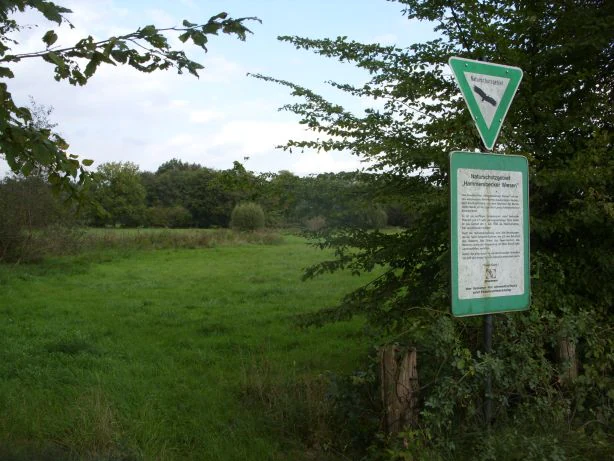
A green-and-white nature reserve sign on a metal post at the edge of a green meadow, with trees in the background.
A nature reserve sign at the entrance to the Hammersbecker Wiesen, a protected area of meadows and wetlands.

Hammersbecker Wiesen history and protected-area timeline

The Hammersbecker Wiesen area has long functioned as agricultural meadowland within the Vegesacker Geest, but rising recognition of its ecological value led to its formal protection in the late twentieth century. On 22 July 1986, the area was officially designated as a Naturschutzgebiet under the Bremen nature protection register, where it carries the identifier number 6.

At the time of its original designation, the reserve covered approximately 27.2 hectares. In March 2014, its boundaries were formally adjusted to the current area of about 25.8 hectares, refining the extent of the protected meadows and stream corridor. Throughout its history, conservation responsibility for the site has rested with the Bremen Senator for Environment, Building, and Transport, which continues to oversee its management and protection today.

Hammersbecker Wiesen landscape and geographic character

The reserve lies in the Vegesacker Geest, a gently undulating sandy landscape north of Bremen that rises only modestly above sea level; the protected area itself sits between roughly 17 and 25 meters in elevation. The terrain is shaped by glacial and periglacial Geest processes and then modified by the small Beckedorfer Beeke stream, which has cut a narrow valley through the sandy uplands and created a moist floodplain beneath.

Within this subtle topography, the landscape is structured by hedgerows, scattered trees, reedbeds, small swampy depressions, and the open meadow matrix that gives the site its name. In the southern part of the reserve, the former clay pit known as the Pottkuhle forms a small enclosed hollow ringed by alder and willow thickets, contrasting with the open grassland that surrounds it. The result is a small-scale mosaic where field, hedge, scrub, water, and meadow constantly change the view across even short distances.

Hammersbecker Wiesen ecosystems, habitats, and plant life

Ecologically, Hammersbecker Wiesen is a textbook example of a Geest wet meadow complex, combining damp grassland, marshy zones, tall herb vegetation, reedbeds, hedgerows, scrub, and a near-natural brook. The Beckedorfer Beeke runs through the reserve as a small, relatively undisturbed lowland stream, and its floodplain provides the moisture gradient that supports much of the site's botanical richness.

The wet meadows support a wide range of moisture-loving plants, including marsh marigold, ragged robin, yellow flag iris, marsh forget-me-not, large and small rattle, brooklime, creeping bugle, and various sedges and rushes such as remote sedge, bladder sedge, and thread rush, alongside grasses including meadow brome. On slightly drier sections, meadow cress, creeping and bulbous buttercup, and red clover add to the floral mix. Slightly elevated patches, hedge understories, and swampy hollows host their own distinctive species groups, ranging from primrose and wood anemone in shaded edges to tubular water dropwort and flote grass in wetter stands.

Hedgerows of blackthorn, bramble, elder, hawthorn, and dog rose, with ivy, hop, and honeysuckle weaving through them, give the meadows structural variety. Pedunculate oak, hornbeam, alder, and willow appear in the woody layer, providing nesting and shelter habitat throughout the reserve. A 2012 biotope survey documented about 270 plant species, underscoring the unusually high botanical density for such a small Bremen site.

Hammersbecker Wiesen wildlife and species highlights

Despite its compact size, Hammersbecker Wiesen supports a varied community of animals that depend on the mosaic of wet meadows, scrub, hedges, and water. Numerous songbirds breed in the hedgerows and shrubby edges, including species such as the Eurasian blackcap, the winter wren, and the dunnock, all of which favor dense low vegetation. The reserve also has documented significance for typical meadow birds tied to damp open grassland.

The wetter parts of the site, including the Beckedorfer Beeke, its floodplain, the swampy hollows, and the small pond-like features, provide habitat for amphibians. Common frogs and common toads are described as occurring in large populations, taking advantage of the moisture and standing water typical of Geest meadow habitats. Insects also thrive in the structured meadowscape: beetles and hoverflies are highlighted as notable groups that depend on the combination of flowers, dead wood, scrub, and water.

Together, these fauna communities make the reserve a small but functioning refuge for lowland meadow wildlife within the city-state of Bremen.

Hammersbecker Wiesen conservation status and protection priorities

Hammersbecker Wiesen holds clear conservation significance as one of Bremen's most botanically diverse protected areas and as a key node in the regional network of meadow and stream habitat. Its legal status as a Naturschutzgebiet, dating back to 1986, provides strong statutory protection against development and destructive land use, while its role as protection area number 6 in Bremen's nature register reflects its recognized importance at the city-state level.

The reserve's value is both local and landscape-scale. Locally, it safeguards habitat for rare and characteristic meadow species, including Bremen's largest population of the broad-leared marsh orchid, as well as amphibians, songbirds, and a rich insect fauna. At the landscape level, it connects directly to the adjacent Lower Saxon landscape protection area Bremer Schweiz and to surrounding Bremen landscape protection areas, forming a continuous corridor of meadow, hedgerow, and stream habitat across the state border. Extensive grazing with Angus cattle, controlled boundaries, and long-term protection have together maintained the open, species-rich character of the meadowscape.

Hammersbecker Wiesen cultural meaning and human context

The Hammersbecker Wiesen area is rooted in the rural and agricultural history of the Vegesacker Geest, where small farmsteads and traditional hay meadows long shaped the northern Bremen landscape. The place name itself reflects this heritage: Wiesen, or meadows, points to centuries of grassland use in a region otherwise dominated by sandy Geest soils. The presence of the Pottkuhle, a former clay pit, also hints at small-scale historical extraction activity alongside farming.

In the modern era, the cultural role of the site has shifted from working farmland to a protected natural heritage site within an urban city-state. Although the reserve is not open to the public on foot, it is viewed and stewarded as a shared ecological legacy linking Bremen's more rural Geest traditions with the surrounding Lower Saxon countryside.

Top sights and standout views in Hammersbecker Wiesen

Hammersbecker Wiesen stands out for combining unusually high botanical diversity with a compact, easily understood habitat mosaic. Within just 25.8 hectares it contains wet meadows, hedgerows, reedbeds, tall herb communities, swampy hollows, and a near-natural Geest brook, supporting around 270 recorded plant species including Bremen's largest known population of the broad-leaved marsh orchid.

Equally notable are the reserve's breeding songbirds, meadow birds, and amphibians, especially common frogs and common toads, which thrive in the wet meadow and stream habitat. The reserve's connection to the Lower Saxon landscape protection area Bremer Schweiz adds a cross-border conservation dimension, making it a small but meaningful corner of Bremen where traditional Geest meadowland is still actively preserved.

Best time to visit Hammersbecker Wiesen

Hammersbecker Wiesen is fundamentally a conservation site rather than a walking destination. The reserve itself is not open to visitors, and the area can only be observed from surrounding public roads, so the experience is one of viewing and appreciation rather than entry. After a long German winter, the wet meadows begin to green up in early spring, and late spring into early summer is when meadow plants such as marsh marigold, ragged robin, and the broad-leaved marsh orchid are most visibly in bloom, giving the meadowscape its richest color and ecological peak.

Late summer and early autumn bring mature seedheads and tall herb flowering along the hedgerows and stream edges, while the open grassland character is best appreciated in the warmer half of the year when the contrast between yellow-green meadows, dark hedgerows, and alder-willow scrub is strongest. Cooler months still reveal the structural beauty of the landscape, with the Beckedorfer Beeke and the Pottkuhle clay pit hollow standing out clearly against the surrounding grazed fields.


Monthly climate preview

Long-term representative measurements of temperature and precipitation for Bremen

Hammersbecker Wiesen Climate Normals and Annual Temperature Rhythm

Historical averages for Hammersbecker Wiesen document a recorded mean annual temperature range spanning from near freezing up to eighteen degrees Celsius alongside stable daily precipitation rates. Examining the full twelve-month profile provides deeper context for tracking monthly meteorological baselines across the protected area.
Annual mean9 °C
1 °C18 °C
Jan
Feb
Mar
Apr
May13°
Jun16°
Jul18°
Aug18°
Sep14°
Oct10°
Nov
Dec
Warmest month
July

18 °C

Coolest month
January

1 °C

Wettest month
July

2.5 mm/day

Driest month
April

1.4 mm/day

Park location guide

Geography guide, regional context, and park location map for Hammersbecker Wiesen

Hammersbecker Wiesen park geography, regions, and map view in Germany

Understand where Hammersbecker Wiesen sits in Germany through a broader geographic reading of the surrounding landscape, nearby location context, and its mapped position within the national park landscape.

How Hammersbecker Wiesen fits into Germany

Germany is a federal republic in Western and Central Europe with a population of over 83 million across sixteen constituent states. It is Europe's largest economy by nominal GDP and a major global exporter and importer. The capital is Berlin, and the country borders Denmark, Poland, Czech Republic, Austria, Switzerland, France, Luxembourg, Belgium, and the Netherlands.

Wider geography shaping Hammersbecker Wiesen in Germany

Germany is located in Western and Central Europe, spanning 357,022 km². It borders Denmark to the north, Poland and the Czech Republic to the east, Austria and Switzerland to the south, and France, Luxembourg, Belgium, and the Netherlands to the west. The country has coastlines on the Baltic Sea and North Sea to the north, with the Alps located in the southern region.

Map view of Hammersbecker Wiesen

Use this park location map to pinpoint Hammersbecker Wiesen in Germany, understand its exact geographic position, and read its mapped placement within the surrounding landscape more clearly.

Pigeon | © OpenStreetMap contributors

Location context for Hammersbecker Wiesen

Bremen

Visual exploration of wet meadows, hedgerows, and stream valley habitats

Hammersbecker Wiesen Photos and Landscape Scenery

Visual records capture the damp grasslands, winding stream valleys, and hedgerow matrices that define the protected nature reserve. Photographic documentation reveals the subtle terrain variations and native plant communities sustaining local biodiversity across the protected landscape.

A green-and-white nature reserve sign on a metal post at the edge of a green meadow, with trees in the background.

Park atlas

Compare surrounding regional reserves and lowland meadow habitats.

Parks Near Hammersbecker Wiesen And Connected Protected Landscapes

Browsing parks near Hammersbecker Wiesen reveals wider ecological connections across the Vegesacker Geest and adjacent Lower Saxon protected areas. Expanding the view beyond individual wet meadow reserves provides deeper context for regional conservation terrain and lowland habitat distribution.
Nature reserveBremen
About 5.2 km away#1 closest

East

Ruschdahlmoor Nature Reserve: Deep Peatlands and Protected Wetland Geography in Bremen

Geological subsidence sinkhole and urban protected landscape

Ruschdahlmoor stands as a unique nature reserve in Bremen, Germany, distinguished by a peat-forming wetland developed inside a sinkhole over the Lesum salt dome. This protected area supports tall herb meadows, reed-fringed ponds, and rare peat-depth records, offering a dense, ecologically rich landscape context that remains a vital part of the city's natural geography.

Area
0.048 km²
Established
1991
IUCN
IV
Relief
Lowland
A horizontal watercolor painting depicting a soft-focus landscape with a pond in the foreground, pink and green heath vegetation, and distant tree lines under a pale sky.
Nature reserveBremen
About 5.2 km away#2 closest

West

Eispohl, Sandwehen und Heideweiher: Protected Landscape and Geest Geography

Nature reserve featuring historic dunes and heath pond networks

This nature reserve in Bremen protects a remnant of the Rekumer Geest, featuring a complex of inland dunes, wet heath, and small heath ponds. Through its combination of extensively grazed grasslands and mixed forests, the area serves as a vital habitat corridor, maintaining the traditional Geest landscape patterns that once dominated the region between Bremen and the lower Weser.

Area
0.036 km²
Established
1988
Relief
Lowland
Climate
Temperate
Nature reserveBremen
About 5.3 km away#3 closest

Southeast

Dunger See Nature Reserve: Mapped Protected Wetland and Landscape Geography in Bremen

A structured geographic look at the Werderland bird protection habitat.

Dunger See is a compact, ecologically diverse nature reserve in Bremen, shaped by intentional land management to provide critical nesting and wintering grounds for wildfowl. This protected area stands out for its indented shoreline, artificial island clusters, and surrounding woodland buffers that contrast with the open agricultural terrain of the wider Werderland landscape.

Area
0.33 km²
Established
1990
Relief
Lowland
Climate
Temperate
A horizontal watercolor painting showing a tranquil lake scene with green trees, low-lying hills in the distance, and grassy banks against a white background.
Nature reserveBremen
About 7.8 km away#4 closest

Southeast

Grambker Feldmarksee Nature Reserve: Mapping the Protected Landscapes of Bremen

A vital wetland sanctuary shaped by regional infrastructure and natural restoration

Grambker Feldmarksee offers a focused look at how post-industrial quarry sites evolve into ecologically dense nature reserves. This groundwater-fed lake in Bremen acts as a green island, showcasing mature woodland fringes and specialized wetland habitats that are integral to the local bird protection network.

Area
0.226 km²
Established
2009
Relief
Lowland
Climate
Temperate
Nature reserveBremen
About 8 km away#5 closest

East

Untere Wümme Nature Reserve: Riverine Biodiversity and Protected Tidal Landscapes in Bremen

Protected floodplain geography and tidal river habitats.

This nature reserve protects the meandering lower course of the Wümme river, showcasing one of northern Germany's few freshwater tidal systems. Spanning reedbeds, willow forests, and open mudflats, the reserve forms a vital corridor for migratory fish and waterfowl, reflecting a complex mosaic of protected riverine ecosystems and historic meadow landscapes.

Area
1.485 km²
Established
1991
Relief
Lowland
Climate
Temperate
Nature reserveLower Saxony
About 13 km away#6 closest

South

Stenumer Holz Nature Reserve: Protected Ancient Woodland Geography in Lower Saxony

A detailed map-based overview of ancient oak and beech forest ecosystems

Stenumer Holz functions as a critical nature reserve within the Oldenburg district, preserving an ancient broadleaf forest mosaic that stretches across 96 hectares of sandy-geest terrain. The area is defined by its diverse structural composition, including moist oak-hornbeam stands, drier Luzula beech ridges, and narrow alluvial corridors that support specialized woodland flora and old-growth ecological features.

Area
0.96 km²
Established
2018
Relief
Lowland
Climate
Temperate
A watercolor painting showing a soft, panoramic view of a flat wetland area with green trees, a solitary tree in the middle, and industrial silos faintly visible in the background.
Nature reserveBremen
About 13 km away#7 closest

Southeast

Hochwasserschutzpolder zwischen Senator-Apelt-Straße und Neustädter Hafen: Bremen Protected Lands

A vital wetland reserve integrating flood management and avian biodiversity in the port district.

Located within the port district of Bremen, the Hochwasserschutzpolder zwischen Senator-Apelt-Straße und Neustädter Hafen is a notable protected area that balances essential flood-control infrastructure with rich ecological functions. The reserve sustains a variety of wetland bird populations across its reed-lined waters and alluvial woodlands, providing a critical haven for wildlife amidst the surrounding industrial and urban development of the Lower Weser region.

Area
0.847 km²
Established
2014
IUCN
IV
Nature reserveLower Saxony
About 15 km away#8 closest

North

Südliches Hagener Königsmoor Nature Reserve: A Protected Peatland in Lower Saxony

Ecological mosaic of bog woodland and historical peat cuttings

Südliches Hagener Königsmoor is a protected nature reserve in Hagen im Bremischen, Lower Saxony. The terrain features a distinct mosaic of raised bog vegetation, drainage channels, and water-filled peat cuttings that anchor a rare remnant of the original lowland moor landscape against modern agricultural surroundings.

Area
0.85 km²
Established
1981
IUCN
IV

Common questions about visiting, size, designation, and location context for Hammersbecker Wiesen

Hammersbecker Wiesen FAQs for park facts, access, geography, and protected area context

Find quick answers about Hammersbecker Wiesen, including protected-area facts, park geography, trail and visitor context, and how the park fits into its surrounding country and regional landscape.
MoriAtlas Explorer

Continue Your Protected Areas Search Across the Global Atlas

Deepen your exploration by continuing the structured search for national parks and protected areas worldwide. Utilize the comprehensive filtering capabilities to compare different conservation landscapes and refine your understanding of global park geography. Discover more about the distribution and characteristics of protected natural areas.

Global natural geography