Mori Atlas logo
Nature reserveHartensteiner Wald

Tracing the protected boundaries and varied terrain along the Zwickauer Mulde river valley

Hartensteiner Wald Nature Reserve: A Detailed Geographic Atlas of Saxon Woodland and River Valley Protected Landscapes

(Naturschutzgebiet Hartensteiner Wald)

Hartensteiner Wald serves as a critical nature reserve within the Free State of Sachsen, representing a complex mosaic of woodland and riverine habitats along the Zwickauer Mulde. This protected area bridges the lower Westerzgebirge and the Erzgebirgsvorland, offering a distinct study in geological outcrops and forest management. Through this atlas entry, observe the integrated habitat corridors, including the Prinzenhöhle fissure and the prominent Knoblauchfelsen, which highlight the intersection of medieval mining history and ecological preservation in eastern Germany.

protected forestbeech woodlandriver valleyMulde valleyNatura 2000FFH site

Hartensteiner Wald

Nature reserve

Park overview

Structured park overview, official facts, and landscape profile for Hartensteiner Wald

Hartensteiner Wald park facts, protected area profile, and essential visitor context

Review the core facts for Hartensteiner Wald, including designation, size, terrain, visitor scale, habitats, and operating context in one park-focused overview.

About Hartensteiner Wald

The Hartensteiner Wald nature reserve occupies a distinctive niche in the Saxon protected-area system. Although relatively small in absolute area, its significance is amplified by its position within a much larger landscape protection area and its inclusion in the European Natura 2000 network. The reserve stretches along both sides of the Zwickauer Mulde between the Burg Stein and the Prinzenhöhle, extending west into the Steinwald and east toward the boundary of the Landkreis Zwickau. Its location between the lower slopes of the Westerzgebirge and the gentler Erzgebirge foreland gives it a transitional landscape character that mixes valley features with upland forest.

Ecologically, the reserve reflects a deliberate shift away from centuries of communal forest management. Late 20th-century changes in land use, tied to Natura 2000 obligations, ended the traditional working forest economy in the communal woodlands, allowing the forest composition to gradually return toward a more natural state through careful protection and supplementary planting. The vegetation includes characteristic Hainsimsen beech forest alongside spruce, with diverse understory flora such as wild garlic, toothwort species, Turk's-cap lily, and various ferns and vetches that give the woodland a rich seasonal character.

The cultural and geological layer of the reserve adds a second dimension to its identity. The Prinzenhöhle, an 18-meter-long rock fissure originally developed as a medieval mine gallery, is locally famous for its connection to the Kunz von Kaufungen legend. Below it stands the Forsthaus Zur Prinzenhöhle, which doubles as a forest restaurant and visitor waypoint, while the Knoblauchfelsen provides another notable rocky landmark within the forest. Walking routes such as the Dreibrückenweg, Mühlweg, Lößnitzer Weg, and Muldentalwanderweg connect the reserve to surrounding trails and to the broader Mulde valley.

Quick facts and research context for Hartensteiner Wald

Hartensteiner Wald is a Saxon nature reserve of roughly 89 hectares (C 04 designation) inscribed within a larger landscape protection area of about 90 hectares south of the town of Hartenstein.

First placed under protection in 1961 during the GDR period, the reserve had its status renewed after German reunification and is now part of the Natura 2000 Muldetal bei Aue site. Its location between the lower Westerzgebirge and the Erzgebirge foreland gives it a transitional character between upland and valley ecosystems, with the Zwickauer Mulde as its central geographical axis.

Protection and recognition

Documented terrestrial protected area designation and management scope details.

Hartensteiner Wald Protection Status and Conservation History

Hartensteiner Wald maintains a documented terrestrial protection status established in 2001. Official records outline the designation timeline and management scope without additional international recognition sources.

Protection details

Protection scope
Terrestrial
Designated year
2001
Transboundary protection
No
WDPA ID
163533
Park context

Deeper park guide and search-rich context for Hartensteiner Wald

Hartensteiner Wald history, landscape, wildlife, and travel context

Explore Hartensteiner Wald through its history, landscape character, ecosystems, wildlife, conservation priorities, cultural context, and seasonal travel timing in a structured park guide built for atlas discovery and search intent.

Why Hartensteiner Wald stands out

Hartensteiner Wald is best known for combining a Natura 2000 woodland reserve with striking cultural and geological curiosities along the Mulde valley. The reserve protects native beech and mixed forest communities that have been allowed to recover after centuries of community woodland use. Alongside its ecological character, the area is distinguished by features such as the Prinzenhöhle, an 18-meter medieval mining fissure tied to local legend, and the Knoblauchfelsen rock outcrop. Together, these elements give the reserve a hybrid identity as both a habitat protection site and a compact cultural-natural landscape along the Zwickauer Mulde.
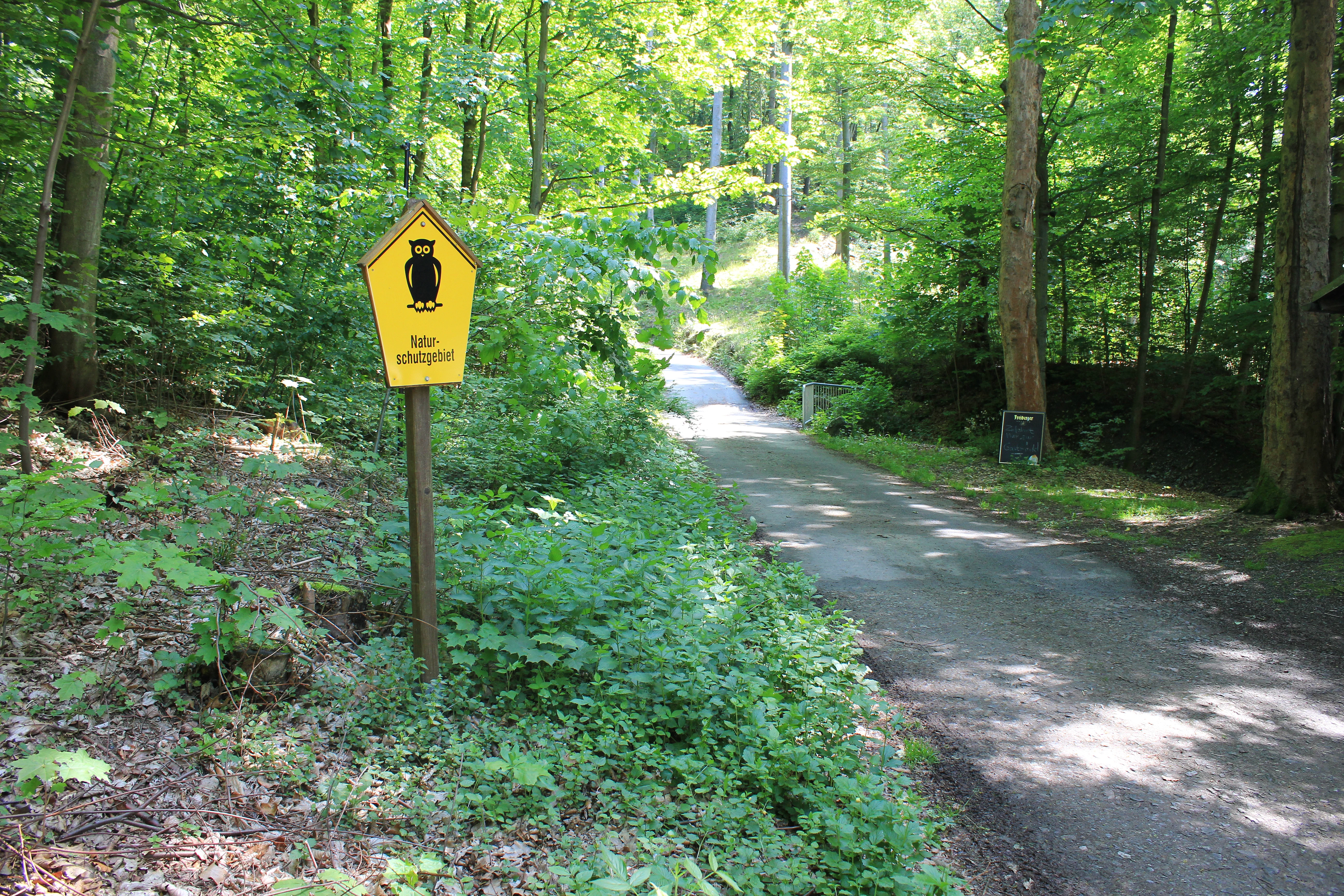
A yellow sign in the shape of a house with an owl icon and German text stands next to a forest path in a green, wooded area.
A pentagonal yellow sign marking the entrance to the Hartensteiner Wald nature reserve.

Hartensteiner Wald history and protected-area timeline

The Hartensteiner Wald was first placed under formal nature protection in 1961, during the period of the German Democratic Republic. At that time, the area was recognized for its ecological and landscape-historical significance, representing roughly a thousand years of Saxon land-use history between Hartenstein and Bad Düben.

After German reunification, the reserve's status was renewed in 1993, aligning it with the new federal and European conservation framework. In 2001, the Saxon state government published an updated decision confirming the reserve's continued protection under the designation NSG C 04. With this re-designation, the reserve became formally integrated into the European Natura 2000 network through its inclusion in the FFH site known as Muldetal bei Aue. The Natura 2000 framework effectively ended the previous communal forestry regime in the area, opening the way for a gradual return toward near-natural woodland composition through protective management and selective replanting.

Hartensteiner Wald landscape and geographic character

The landscape of the Hartensteiner Wald is shaped by the valley of the Zwickauer Mulde, which runs through the reserve as its central axis. The terrain rises from the river valley into the wooded slopes of the Steinwald to the west and continues eastward toward the edge of the Landkreis Zwickau. This gives the reserve a continuous gradient between the river floodplain and the surrounding hills.

Geologically, the area combines soft valley terrain with harder rocky outcrops, of which the Knoblauchfelsen is the most prominent. The Prinzenhöhle, a fissure-style cave feature, was historically enlarged through medieval mining activity and now reads as a distinct cleft in the valley rock. State roads S 283 and S 255 pass to the north and east of the area, while named local paths such as the Tieftalweg, Dreibrückenweg, and Lößnitzer Weg mark parts of its boundary.

The surrounding landscape protection area broadens the visual context well beyond the reserve itself, framing the woodland within the broader transition zone between the lower Westerzgebirge and the Erzgebirgsvorland. Within the larger protected mosaic, smaller features such as the Erlen-Auwald Stein floodplain forest, the Steiner Schlosshang slope, the Schlosspromenade, and the so-called Hochzeits-Eichen oaks add further landscape detail and texture to the area.

Hartensteiner Wald ecosystems, habitats, and plant life

Ecologically, Hartensteiner Wald functions as a habitat and species management area under IUCN Category IV, focused on maintaining and restoring near-natural forest conditions. The woodland is dominated by beech forest of the Hainsimsen type, interspersed with spruce stands that reflect the area's historical forestry use. Understory vegetation is unusually diverse for a relatively small area, with characteristic spring flora such as wild garlic, bulbous coralroot, and various toothwort species, alongside Turk's-cap lily, bird's-nest orchid, and forest vetch.

The reserve's position along the Zwickauer Mulde adds a riparian and valley element that contrasts with the surrounding slopes. Moist meadow margins support species such as Japanese knotweed, while sheltered pockets harbor rarer ferns including the northern and brown-stalked strap ferns. Habitat elements named explicitly under Saxony's nature conservation law include those important for reproduction, feeding, migration, passage, and wintering, framing the woodland as a multi-functional habitat rather than a single-purpose reserve.

Outside the strict reserve boundaries, the broader landscape protection area expands the ecological value of the site, including the Erlen-Auwald Stein alder floodplain forest, which extends woodland and freshwater habitat along the Mulde. The combined effect is a mosaic where upland forest, valley slopes, and floodplain woodland reinforce one another as a coherent ecological unit within the Natura 2000 Muldetal bei Aue site.

Hartensteiner Wald wildlife and species highlights

The wildlife profile of Hartensteiner Wald combines woodland-specialist birds, bats, amphibians, and a notable assemblage of butterflies. Nesting and breeding habitat along the Mulde valley supports eagle owl and black woodpecker, while the old-growth character of parts of the forest attracts grey-headed woodpecker, stock dove, and tengmalm's owl. Forest bat species recorded here include the barbastelle, the greater mouse-eared bat, and the Daubenton's bat, reflecting the importance of mature woodland and shelter features for roosting.

The reserve also has a particular significance for butterflies, with protected species such as the large white admiral, the lesser purple emperor, and the scarce large purple emperor present, alongside other woodland butterflies observed in the area. The fire salamander is recorded in the spring area of the Ottertal, indicating healthy amphibian habitat in the moist valley zones.

Broader bird surveys have added a wider community of woodland and riparian species including green woodpecker, Eurasian jay, coal, crested, blue, and great tits, goldcrest, nuthatch, great grey shrike-like waterbirds such as the white-throated dipper, and visitors such as the great egret. Additional species such as tawny owl, marsh tit, blackcap, treecreeper, and wren have been recorded in recent observation periods, suggesting a stable and diverse breeding and wintering assemblage throughout the protected forest and adjoining valley.

Hartensteiner Wald conservation status and protection priorities

As a formally designated Naturschutzgebiet and a component of the Natura 2000 network, Hartensteiner Wald plays an outsized conservation role relative to its modest size. Its protection history, dating back to 1961 and renewed in 1993, gives it one of the longer continuous conservation records in the region. The 2001 Saxon state government's conservation decision explicitly recognized habitats important for breeding, feeding, migration, passage, and wintering, framing the reserve as a multi-functional refuge within a heavily altered Saxon landscape.

The Natura 2000 designation, through inclusion in the FFH site Muldetal bei Aue, has shifted the area's management away from active timber extraction toward protection-led recovery. Former communal woodland practices were abandoned at the end of the 20th century, and the forest is now being guided toward a near-natural state through controlled protection and careful replanting. This combination of historical protection status, Natura 2000 obligations, and active habitat recovery gives the reserve a layered conservation significance that extends beyond its 89-hectare core.

Within the regional context, the reserve sits inside a much larger landscape protection area, which functions as a buffer and ecological corridor. Together with nearby protected elements such as the Erlen-Auwald Stein floodplain forest, the Steiner Schlosshang, and the Schlosspromenade, the reserve contributes to a continuous network of forest, slope, and riparian habitats along the Zwickauer Mulde.

Hartensteiner Wald cultural meaning and human context

The cultural dimension of Hartensteiner Wald is anchored in the medieval mining history of the Mulde valley and in the regional folklore surrounding the Prinzenhöhle. The cave feature itself was originally created as a mining gallery in the Middle Ages and is locally associated with the legend of Kunz von Kaufungen, in which two knights are said to have hidden a kidnapped prince in the fissure. The Prinzenhöhle's name preserves this story, making the rock formation as much a cultural landmark as a geological one.

The forest also carries a long communal land-use history, with local woodland management traditions that shaped the forest structure for generations before conservation priorities changed in the late 20th century. Today, the Forsthaus Zur Prinzenhöhle operates as a forest restaurant and waypoint for hikers, providing a tangible link between historical forest use and modern recreational use. The Hochzeits-Eichen, or wedding oaks, within the broader landscape protection area add a further cultural layer, marking local tradition and memory within the protected landscape.

Top sights and standout views in Hartensteiner Wald

The Hartensteiner Wald reserve stands out for its combination of a Natura 2000 woodland with cultural heritage features along the Zwickauer Mulde. The Prinzenhöhle and the Knoblauchfelsen give the forest a recognizable geological and historical character that elevates it above many similarly sized lowland reserves. At the same time, the habitat value of the area, especially for woodland birds, bats, butterflies, and amphibians, gives it a strong conservation profile.

The reserve's location on the boundary between the lower Westerzgebirge and the Erzgebirge foreland, combined with the valley setting of the Mulde, creates a layered landscape that mixes slope forest, valley woodland, and rocky outcrops within walking distance of each other. For visitors interested in combining protected nature, short hikes, and Saxon cultural landscape, Hartensteiner Wald offers a compact but unusually varied experience.

Best time to visit Hartensteiner Wald

The reserve can be enjoyed throughout much of the year, with seasonal variation mainly shaping the experience rather than accessibility. Spring is particularly attractive for visitors interested in woodland flora, when species such as wild garlic, toothwort, and other characteristic forest herbs create a rich understory across the beech and spruce stands. Late spring and early summer bring active birdlife, with breeding species of the Mulde valley and the mixed forest most easily observed along paths such as the Muldentalwanderweg.

Summer offers the fullest landscape experience, with dense foliage, the warmest walking conditions, and the best chance to see butterflies and other warm-weather insects around forest margins and rocky outcrops such as the Knoblauchfelsen. Autumn gives the woodland a different mood, with beech and mixed forest coloration that suits the cultural features of the area, including the medieval Prinzenhöhle and nearby Burg Stein. Winter visits are quieter and allow easier observation of woodland structure and any resident birdlife, though they typically involve shorter daylight hours and cooler conditions on the valley paths.

Monthly climate preview

Long-term representative monthly precipitation and temperature patterns across Sachsen

Hartensteiner Wald Climate Normals and Annual Temperature Rhythm

Historical data records a measured annual temperature span from negative winter minimums to warm summer highs alongside steady monthly precipitation rates. Exploring the full twelve-month profile provides complete historical averages for Hartensteiner Wald weather by month.
Annual mean7 °C
-3 °C17 °C
Jan-3°
Feb-2°
Mar
Apr
May12°
Jun15°
Jul17°
Aug17°
Sep13°
Oct
Nov
Dec-1°
Warmest month
July

17.5 °C

Coolest month
January

-2.5 °C

Wettest month
July

2.8 mm/day

Driest month
April

1.4 mm/day

Park location guide

Geography guide, regional context, and park location map for Hartensteiner Wald

Hartensteiner Wald park geography, regions, and map view in Germany

Understand where Hartensteiner Wald sits in Germany through a broader geographic reading of the surrounding landscape, nearby location context, and its mapped position within the national park landscape.

How Hartensteiner Wald fits into Germany

Germany is a federal republic in Western and Central Europe with a population of over 83 million across sixteen constituent states. It is Europe's largest economy by nominal GDP and a major global exporter and importer. The capital is Berlin, and the country borders Denmark, Poland, Czech Republic, Austria, Switzerland, France, Luxembourg, Belgium, and the Netherlands.

Wider geography shaping Hartensteiner Wald in Germany

Germany is located in Western and Central Europe, spanning 357,022 km². It borders Denmark to the north, Poland and the Czech Republic to the east, Austria and Switzerland to the south, and France, Luxembourg, Belgium, and the Netherlands to the west. The country has coastlines on the Baltic Sea and North Sea to the north, with the Alps located in the southern region.

Map view of Hartensteiner Wald

Use this park location map to pinpoint Hartensteiner Wald in Germany, understand its exact geographic position, and read its mapped placement within the surrounding landscape more clearly.

Pigeon | © OpenStreetMap contributors

Location context for Hartensteiner Wald

Sachsen

Visualizing native beech woodland, rocky outcrops, and river valley habitats

Hartensteiner Wald Photos and Landscape Scenery Exploration

Examine detailed photographs showcasing the protected habitats, rolling terrain, and geological features of Hartensteiner Wald. Visual records reveal the diverse forest communities and river valley topography that define this eastern German nature reserve.

A yellow sign in the shape of a house with an owl icon and German text stands next to a forest path in a green, wooded area.

Park atlas

Compare adjacent woodland reserves and regional protected landscapes across Saxony

Parks Near Hartensteiner Wald and Surrounding Protected Natural Areas

Browse other protected areas near Hartensteiner Wald to examine connected river valleys and regional forest habitats. Expanding the geographic comparison reveals broader ecological patterns across the surrounding hills and river basins.
Nature reserveSaxony
About 10 km away#1 closest

Southwest

Heide und Moorwald am Filzteich: Nature Reserve and Bog Landscape in Saxony

Protected moorland forest and heathland geographic context

Heide und Moorwald am Filzteich provides a unique look at habitat management in the Erzgebirge region. This nature reserve, adjacent to the Filzteich reservoir, encompasses a protected mosaic of open heath, remnant bog systems, and historical peatland terrain. Its geographic boundaries offer insights into the transitional landscapes of the Saxon uplands and local water table influences on wetland biodiversity.

Area
3.14 km²
Established
2010
IUCN
IV
Nature reserveSachsen
About 12 km away#2 closest

South

Conradswiese Nature Reserve: Geographic Overview of the Saxon Ore Mountains Forest Meadow

Protected mountain meadow and mixed forest terrain in Sachsen.

Conradswiese encompasses a distinct Waldwiese clearing embedded within the Bergmischwald of the western Ore Mountains. Located near the Morgenleithe, this nature reserve is positioned along a watershed boundary between two river systems, making it a point of geographic interest for those exploring the natural heritage and silvicultural history of Germany.

Area
38.97 km²
IUCN
IV
Nature reserveSachsen
About 19 km away#3 closest

South

Friedrichsheider Hochmoor Nature Reserve: Geography and Protected Bog Landscape in Sachsen

High-elevation peatland and bog pine forest mapping

Situated at 800 meters above sea level near Sosa, Friedrichsheider Hochmoor serves as a cornerstone of peatland conservation in the Erzgebirge. This reserve is defined by its thick peat body and dense Spirken moor forest, offering a rare look at near-intact mire ecosystems that support diverse Sphagnum mosses and subarctic plant communities within a protected regional framework.

Area
0.19 km²
Established
1967
IUCN
IV
A horizontal watercolor illustration of a gentle landscape with scattered trees, soft green foliage, and faint mountain outlines in the background.
Nature reserveSaxony
About 21 km away#4 closest

Southwest

Am Riedert Nature Reserve: Protected Mountain Forest Geography in Saxony, Germany

Analyzing the ecological boundaries and Hercynian mountain mixed forest terrain

Am Riedert is a compact but ecologically important nature reserve situated on the rugged slopes of the western Erzgebirge. This site protects a significant example of mountain mixed forest, characterized by its mature silver fir populations and active natural regeneration. By examining its location south of the Zwickauer Mulde river, visitors can trace the intersection of Saxon history and conservation within this unique protected landscape.

Area
0.185 km²
Established
1961
IUCN
IV
Relief
Mountain
A horizontal watercolor painting showing rolling green hills and distant mountain ridgelines behind a foreground of grassy meadows and trees.
Nature reserveSaxony
About 25 km away#5 closest

South

Dreibächel Nature Reserve: Mapping the Old-Growth Spruce Stands of the Western Ore Mountains

A historic protected landscape and mountain watershed in Saxony, Germany

Dreibächel serves as a living archive of traditional forest management, holding the distinction of containing the oldest spruce trees in Saxony. Located on the slopes of the Schneehübel, the reserve is characterized by a dense, multi-layered mountain forest canopy and the confluence of three vital streams. The area remains a essential site for observing historical plenterwald ecology and the natural hydrology of the Westerzgebirge region.

Area
0.147 km²
Established
1961
IUCN
IV
Nature reserveSaxony
About 25 km away#6 closest

West

Waschteich Reuth Nature Reserve: Mapped Wetland Landscapes of the Saxony Vogtland

Protected pond habitats and regional woodland ecosystems

Waschteich Reuth serves as a compact yet ecologically rich nature reserve in the Vogtland. Its protected boundaries encompass a traditional pond with floating-leaf vegetation, damp meadows, and native oak-hornbeam forest. This site stands as a prime example of Saxony's wetland heritage, illustrating the importance of small-scale habitat preservation within the broader German river network.

Area
0.212 km²
Established
1995
Water
Major water bodies
Watercolor painting of a flat marshy landscape with a small winding stream in the foreground, green trees in the midground, and soft purple mountain silhouettes in the distance.
Nature reserveSaxony
About 25 km away#7 closest

South

Großer Kranichsee Nature Reserve: Protected Raised Bog Geography and Ore Mountain Landscapes

Watershed moorland, mountain pine forests, and Saxony high plateau geography.

Großer Kranichsee serves as a primary example of an intact raised bog system in the Ore Mountains. The reserve features rare peat-forming vegetation and highland bog forests, occupying a high-altitude plateau that bridges the border between Saxony and the Czech Republic. Its geographic significance stems from its role as a triple watershed, defining the drainage patterns for three distinct regional river systems within the protected Erzgebirgskamm zone.

Area
6.11 km²
Established
1912
Natural monumentKarlovarský kraj
About 28 km away#8 closest

South

Vlčí jámy Natural Monument: Protected Geological and Industrial Heritage in Bohemia

Ore Mountains mining collapse and relict microclimate landscape

Vlčí jámy protects a rare intersection of medieval mining history and environmental significance in the Karlovarský kraj. The site is defined by two deep collapse features, Ledová jáma and Vlčí jáma, which function as persistent cold traps. These geological anomalies support critically endangered mosses and bat colonies, illustrating how abandoned industrial landscapes in the Ore Mountains evolve into essential, small-scale protected habitats.

Area
0.014 km²
Established
1975
IUCN
III
Relief
Mountain

Common questions about visiting, size, designation, and location context for Hartensteiner Wald

Hartensteiner Wald FAQs for park facts, access, geography, and protected area context

Find quick answers about Hartensteiner Wald, including protected-area facts, park geography, trail and visitor context, and how the park fits into its surrounding country and regional landscape.
MoriAtlas Explorer

Continue Your Protected Areas Search Across the Global Atlas

Deepen your exploration by continuing the structured search for national parks and protected areas worldwide. Utilize the comprehensive filtering capabilities to compare different conservation landscapes and refine your understanding of global park geography. Discover more about the distribution and characteristics of protected natural areas.

Global natural geography