

Mori Atlas logo
Nature reserveHeipker See

Examining the ecological structure and mapped boundaries of this North Rhine-Westphalia wetland

Heipker See Nature Reserve: A Protected Riparian Landscape in the Werre Valley, Germany

(Naturschutzgebiet Heipker See)

Heipker See is a 24.6 hectare nature reserve located in the Kreis Lippe district of North Rhine-Westphalia, Germany. The area protects a complex mosaic of stillwater lakes formed by past excavation, floodplain woodland relics, and grassland sections along the Werre river valley. This site functions as a significant migration stopover, illustrating the regional importance of compact, diverse riparian habitats in the eastern Westphalian foothills.

nature reservewetlandstillwater lakefloodplain woodlandriparian habitatWerre valley

Heipker See

Nature reserve

Park overview

Structured park overview, official facts, and landscape profile for Heipker See

Heipker See park facts, protected area profile, and essential visitor context

Review the core facts for Heipker See, including designation, size, terrain, visitor scale, habitats, and operating context in one park-focused overview.

About Heipker See

Heipker See is a compact nature reserve in the eastern Westphalian landscape, where the Werre river cuts through lowland terrain between the Teutoburg Forest and the broader Lippe basin. The reserve forms part of a long-term effort in the region to preserve representative sections of the Werre valley, including stands of floodplain woodland that have survived alongside the river and the surrounding agricultural use.

The most distinctive element of the protected area is the stillwater lake from which the reserve takes its name. The lake is itself a product of former excavation activity, illustrating how past land use has shaped modern habitat conditions. The resulting interplay between standing water, the inflowing Heipker Bach, the larger Werre river along the eastern boundary, dry former excavation pits, and adjacent grassland produces a habitat mosaic that, although small in scale, contains an unusually high density of structural elements.

Ecologically, the reserve functions primarily as a refuge for wetland-dependent species and as a rest and forage area for birds on migration. Its floodplain woodland relics, combined with open grassy areas and the lake itself, support a vertical and horizontal habitat diversity that is uncommon for a reserve of this size. Conservation management, overseen by the landscape authority of Kreis Lippe, aims to maintain this habitat mosaic in the face of ongoing regional pressures.

The reserve is closely connected to the wider landscape protection network of the area. Immediately across the Werre, the larger Holzhauser Bruch reserve (around 39.6 hectares, designation LIP-045) continues habitat coverage on the Bad Salzuflen side, meaning that the Werre valley here functions ecologically as a continuous corridor of protected land. Heipker See is therefore best understood not as a stand-alone nature reserve but as a node within a broader Werre valley conservation landscape.

Quick facts and research context for Heipker See

Heipker See is a Naturschutzgebiet (nature reserve under German protected-area law) in Leopoldshöhe, Kreis Lippe, North Rhine-Westphalia. It has an area of approximately 24.6 hectares and carries the official designation LIP-019. The reserve was designated in 1998 and is administered by the Untere Landschaftsbehörde of Kreis Lippe. It is classified as an IUCN Category IV area, meaning a habitat and species management zone. Geographically, the reserve lies in the local area of Heipke in the Krentrup district of Leopoldshöhe and forms part of the Werre river valley landscape.

Protection and recognition

Documented terrestrial protection records and designation timeline details

Heipker See Protection Status and Official Designation History

Heipker See maintains a documented terrestrial protection status established through historical conservation records dating from 1998. Official protection metrics outline the designated management scope and administrative framework associated with the protected area.

Protection details

Protection scope
Terrestrial
Designated year
1998
Transboundary protection
No
WDPA ID
163614
Park context

Deeper park guide and search-rich context for Heipker See

Heipker See history, landscape, wildlife, and travel context

Explore Heipker See through its history, landscape character, ecosystems, wildlife, conservation priorities, cultural context, and seasonal travel timing in a structured park guide built for atlas discovery and search intent.

Why Heipker See stands out

Heipker See is best known for its stillwater lake created by earlier sand or gravel excavation, combined with surviving floodplain woodland relics along the Werre river. The site is notable as a stopover for migratory birds traveling along the Werre valley corridor, where wetland, grassland, and former extraction features create a tight mosaic of habitats in a compact area. It also represents a typical example of how small, structurally diverse reserves in the Lippe region contribute to regional habitat connectivity.
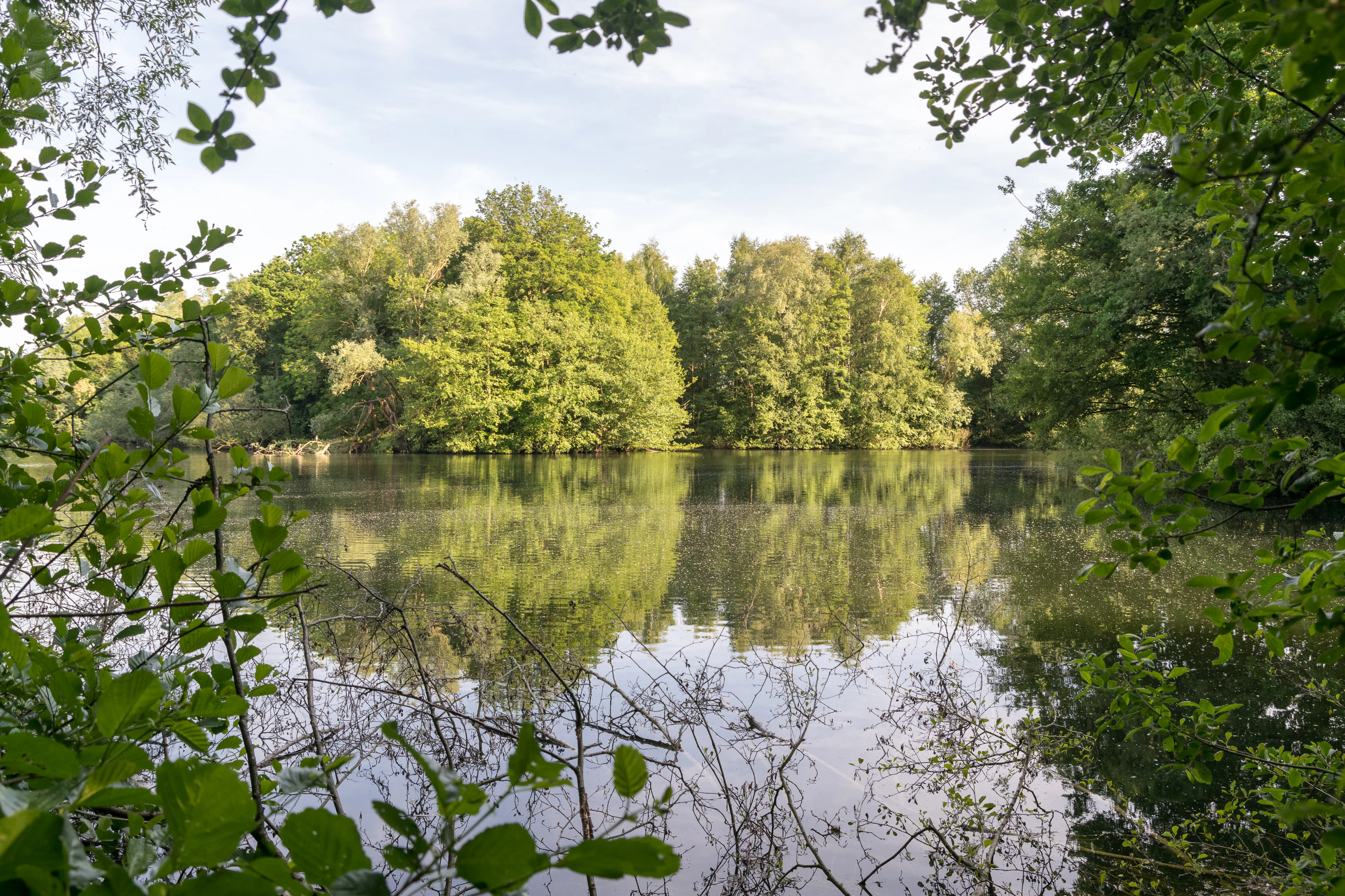
A calm lake surrounded by dense green trees, with the trees reflected in the still water. Branches and leaves frame the foreground.
A view of the Heipker See nature reserve showing a calm lake surrounded by lush green trees with reflections in the water.

Heipker See history and protected-area timeline

The area now protected as Heipker See has a layered human history. Like many sites in the Werre valley, the landscape was modified by earlier extractive activity, in this case old gravel or sand workings whose lingering pits filled with water and gave the reserve its central lake. These former workings, referred to as Trockengrabungen in the reserve documentation, were originally utilitarian but eventually became the defining feature of the protected landscape.

The reserve was formally designated as a Naturschutzgebiet in 1998, giving legal protection to approximately 24.6 hectares of the Werre valley landscape in the municipality of Leopoldshöhe. Administration was placed under the Untere Landschaftsbehörde of Kreis Lippe, the regional landscape authority responsible for managing smaller protected areas in the district. The official identifier LIP-019 places the reserve within the district-wide numbering system used for nature reserves in the Lippe region.

In environmental planning terms, the site is referenced in the Kreis Lippe landscape plan number 2, covering Leopoldshöhe and the northern Oerlinghausen area. Its designation reflects a regional strategy of conserving smaller, structurally diverse habitat patches along the Werre valley, complementing larger reserves such as Holzhauser Bruch on the opposite bank. The reserve has since functioned as one component of a coordinated valley-level approach to landscape protection in the eastern Westphalian lowlands.

Heipker See landscape and geographic character

Geographically, Heipker See sits in the flat to gently rolling lowland country of the eastern Westphalian foothills, where the Werre river flows northward through a broad glacial and post-glacial valley. The relief is subdued, with the river, its tributaries, and the former workings creating the main topographic variation. The Werre marks the eastern boundary of the reserve, separating Leopoldshöhe from the Bad Salzuflen district of Holzhausen.

The center of the protected area is the Heipker See itself, a stillwater lake formed within former excavation pits. The lake is fed and partly drained by the Heipker Bach, a small watercourse that gives the lake and the reserve both their hydrological character and their names. Together, the stillwater, the stream, the river, and the surrounding meadows and woodland fragments create a finely textured riparian landscape in which water dominates the visual identity of the reserve.

Around the water features, the landscape includes patches of floodplain woodland that represent surviving remnants of the once more extensive Auenwald along the Werre. These woodland relics alternate with open grassland, the dry hollows left by earlier extraction, and transitional edge habitats where forest, meadow, and water meet. Although the total area is modest, the landscape reading of Heipker See is one of compressed but clearly visible ecological layering within a single valley reach.

Heipker See ecosystems, habitats, and plant life

Heipker See is a structurally rich reserve concentrated on a small area. The combination of standing water, a flowing stream, the larger river along the boundary, floodplain woodland relics, and open grassland produces a habitat mosaic with a high diversity of ecological niches in a relatively compact footprint. Such compressed diversity is characteristic of well-designed small reserves in agricultural landscapes, where isolated habitat patches must compensate through internal structural complexity.

The floodplain woodland remnants are one of the defining elements of the reserve, representing relicts of the natural Auenwald that once extended along the Werre valley. Their survival in a protected setting creates important forest microhabitats, including damp, shaded ground conditions along the stream and river margins. These are complemented by more open habitats in the former excavation areas and grasslands, allowing species groups with very different ecological requirements to coexist within the reserve.

Hydrologically, the site sits within the Werre valley system, with the Heipker See fed by the Heipker Bach and influenced by the Werre flowing along the eastern edge. This hydrological connectivity links the reserve to larger landscape-scale processes. The combination of stagnant water in the lake, running water in the stream, and the larger river creates a gradient of moisture conditions and habitat types within a very short distance, reinforcing the ecological importance of the reserve beyond its absolute size.

Heipker See wildlife and species highlights

Wildlife at Heipker See reflects the reserve's character as a key stopover on the Werre valley. The site is officially recognized as a resting area for migrating birds (Zugvögel), and its combination of open water, shallow margins, wet woodland, grassland, and dry excavation edges provides a wide range of feeding and cover conditions within a small area. Migratory waterbirds in particular benefit from the stillwater lake, whose calm surface and sheltered location make it suitable for resting during seasonal movements.

The surrounding floodplain woodland fragments provide nesting and shelter opportunities for typical woodland bird species, while open grassland areas support insect populations and, in turn, the bird species that feed on them. The Werre river itself, along the eastern boundary, adds another habitat dimension, with riparian species using the river corridor for foraging and movement.

Although the source documentation does not enumerate individual species in detail, the structural diversity of the reserve implies a correspondingly diverse faunal community. The reserve's ecological value lies less in the presence of single rare species and more in its capacity to support a full seasonal cycle of use: spring and autumn passage of migratory birds, summer breeding in both woodland and open habitat patches, and winter use of sheltered riparian areas.

Heipker See conservation status and protection priorities

Heipker See is classified as an IUCN Category IV area, identifying it as a habitat and species management zone in which active protection of specific habitats and species is the primary conservation objective. This category suits reserves like Heipker See, where the goal is not a fully untouched wilderness but the deliberate maintenance of a particular habitat structure and species assemblage in an otherwise heavily used landscape.

The reserve contributes to conservation at multiple scales. Locally, it preserves a representative segment of the Werre valley habitat complex, protecting floodplain woodland relics and wetland features that would otherwise be vulnerable to further agricultural drainage or land-use change. Regionally, it functions as one node in a network of protected areas along the Werre, including the larger Holzhauser Bruch reserve across the river on the Bad Salzuflen side. Together these reserves form a continuous corridor of protected valley habitat, an arrangement that significantly increases their individual ecological value.

Management responsibility lies with the Untere Landschaftsbehörde des Kreises Lippe, the regional landscape authority, and the reserve is integrated into the Kreis Lippe landscape plan for the Leopoldshöhe and Oerlinghausen-Nord area. The site is also entered in the World Database on Protected Areas under WDPA ID 163614, ensuring its recognition within international conservation datasets. Its importance is therefore both local, in protecting a distinctive Werre valley patch, and systemic, as part of an interconnected regional reserve network.

Top sights and standout views in Heipker See

Heipker See stands out for the unusually high habitat density within a compact area, combining stillwater, stream, river boundary, floodplain woodland relics, grassland, and former excavation pits in a single reserve. Its identity as a Werre valley migration stopover gives it a clear and specific ecological role that extends well beyond its modest size. The reserve's integration with the neighboring Holzhauser Bruch across the Werre creates a transboundary conservation corridor that lifts the conservation value of both sites. As a 1998 designation under the regional landscape authority of Kreis Lippe, it also exemplifies the systematic approach to protecting smaller, structurally critical sites in the agricultural landscape of eastern Westphalia.

Best time to visit Heipker See

Heipker See is a working nature reserve rather than a developed visitor attraction, and visitation should focus on quiet observation of wetland and valley scenery. Spring and autumn offer the greatest ecological interest, as these are the periods when migrating birds use the lake and surrounding habitats as resting and feeding areas. Late spring and early summer also bring active vegetation growth in the floodplain woodland relics and grasslands, while winter provides unobstructed views across the open valley landscape. Birdwatchers typically find the reserve most rewarding during passage seasons, while visitors interested in landscape structure and quiet walks along the Werre can find value year-round in calm weather.

Monthly climate preview

Trace average annual temperatures and precipitation rhythms for Heipker See

Heipker See Climate Normals and Long-Term Monthly Weather Patterns

Long-term data records illustrate how average temperatures and monthly precipitation shift across the year at Heipker See. Reviewing the complete twelve-month normals provides a structured baseline for understanding regional meteorological conditions.
Annual mean9 °C
1 °C18 °C
Jan
Feb
Mar
Apr
May13°
Jun16°
Jul18°
Aug18°
Sep14°
Oct
Nov
Dec
Warmest month
July

18.1 °C

Coolest month
January

0.5 °C

Wettest month
December

2.6 mm/day

Driest month
April

1.6 mm/day

Park location guide

Geography guide, regional context, and park location map for Heipker See

Heipker See park geography, regions, and map view in Germany

Understand where Heipker See sits in Germany through a broader geographic reading of the surrounding landscape, nearby location context, and its mapped position within the national park landscape.

How Heipker See fits into Germany

Germany is a federal republic in Western and Central Europe with a population of over 83 million across sixteen constituent states. It is Europe's largest economy by nominal GDP and a major global exporter and importer. The capital is Berlin, and the country borders Denmark, Poland, Czech Republic, Austria, Switzerland, France, Luxembourg, Belgium, and the Netherlands.

Wider geography shaping Heipker See in Germany

Germany is located in Western and Central Europe, spanning 357,022 km². It borders Denmark to the north, Poland and the Czech Republic to the east, Austria and Switzerland to the south, and France, Luxembourg, Belgium, and the Netherlands to the west. The country has coastlines on the Baltic Sea and North Sea to the north, with the Alps located in the southern region.

Map view of Heipker See

Use this park location map to pinpoint Heipker See in Germany, understand its exact geographic position, and read its mapped placement within the surrounding landscape more clearly.

Pigeon | © OpenStreetMap contributors

Location context for Heipker See

North Rhine-Westphalia

Visualizing the landscape, habitats, and wetland environment of the Werre river valley

Heipker See Photos and Protected Area Scenery

Visual documentation provides a clear window into the topography, water features, and floodplain woodland relics that define the protected landscape. Examining these field photographs reveals the compact ecological layering and habitat density of the nature reserve.

A calm lake surrounded by dense green trees, with the trees reflected in the still water. Branches and leaves frame the foreground.

Park atlas

Compare adjacent wetland reserves and surrounding river valley protected areas.

Exploring Parks Near Heipker See and Connected Regional Protected Landscapes

Browsing other protected areas near Heipker See reveals a broader network of floodplain reserves and river valley habitats across the surrounding region. Extending the geographic comparison uncovers how adjacent conservation sites share similar lowland terrain and wetland characteristics.
Nature reserveNordrhein-Westfalen
About 1.2 km away#1 closest

Southeast

Holzhauser Bruch Nature Reserve: Protected Wetland and Riparian Geography in Nordrhein-Westfalen

Mapping lowland bog and meandering river corridors

Holzhauser Bruch in Nordrhein-Westfalen preserves a compact yet ecologically vital riverine landscape. Its terrain contrasts wet alder-dominated swamp forests with drier, sandy upland slopes. This summary explores the geographic boundary of the reserve, highlighting its role as a representative fragment of the Werre valley habitat system.

Area
0.4 km²
Established
2002
Nature reserveNordrhein-Westfalen
About 5.1 km away#2 closest

Southwest

Windwehetal Nature Reserve: Mapped Protected Brook Valley in Nordrhein-Westfalen

Dynamic stream geography and woodland protected landscapes

Windwehetal represents a compact yet ecologically significant protected area in the German federal state of North Rhine-Westphalia. The reserve showcases near-natural stream dynamics, including undercut slopes reaching three metres, alongside a complex mosaic of gallery woodlands, damp grasslands, and beech forests that define the valley floor and surrounding ridges.

Area
0.565 km²
Established
1998
IUCN
IV
Relief
Upland
Nature reserveNordrhein-Westfalen
About 5.7 km away#3 closest

West

Windweheniederung Nature Reserve: Geographic Atlas of an East Westphalian Floodplain

Riparian ecosystems and protected valley land mapping

Windweheniederung represents a specialized nature reserve in Nordrhein-Westfalen that centers on the natural morphology of the Windwehe stream. This protected area provides a critical refuge for wetland-dependent species through its alder-ash woodland and reed-fringed pools. Explore the structural geography of this lowland catchment and understand its role in maintaining functional floodplains amidst a heavily developed regional environment.

Area
0.297 km²
Established
1991
IUCN
IV
Nature reserveNordrhein-Westfalen
About 6.4 km away#4 closest

North

In der Masch Nature Reserve: Mapped Floodplain Geography in Nordrhein-Westfalen

Protected nature reserve with rare lowland meadow habitats.

In der Masch offers a focused look at protected lowland river-meadow terrain within Germany. This 23-hectare nature reserve in Nordrhein-Westfalen protects interconnected oat-grass grasslands, riparian wood fringes, and historical boundary markers, providing a distinct study in regional floodplain topography and habitat preservation.

Area
0.23 km²
Established
2002
IUCN
IV
Nature reserveNorth Rhine-Westphalia
About 11 km away#5 closest

East

Ilse Nature Reserve: Protected Stream Corridor and Floodplain Geography in North Rhine-Westphalia

Mapped riparian habitats and regional conservation landscape context.

Ilse Nature Reserve serves as a critical protected corridor within the Lippe district, spanning five distinct sections along the Ilse stream. The reserve is defined by its near-natural watercourse, wet meadows, and traditional orchard remnants that safeguard species-rich habitats. This geographic focus provides essential insights into the conservation of lowland stream ecosystems and their role in maintaining the ecological connectivity of the broader Bega river valley.

Area
0.142 km²
Established
2009
IUCN
IV
Relief
Upland
Nature reserveNordrhein-Westfalen
About 14 km away#6 closest

Northeast

Kleiner Selberg Nature Reserve: Protected Landscape and Geographic Mapping

Essential geographic context for the Lipper Bergland protected areas

Kleiner Selberg stands as a prominent hill and nature reserve within the Kreis Herford region. Its landscape is defined by a dense population of juniper shrubs and restored heathland, offering a vital ecological corridor in the Weserbergland. Explore the spatial arrangement of its woodland patches and pasture slopes that characterize this protected hill environment.

Area
0.136 km²
Established
1971
Relief
Mountain
Climate
Temperate
Nature reserveNorth Rhine-Westphalia
About 15 km away#7 closest

North

Naturschutzgebiet Mittelbach Nature Reserve: Mapped Protected Landscapes in Vlotho

Classic Siek stream valley geography and riparian woodland habitats

The Naturschutzgebiet Mittelbach is a protected area in eastern Westphalia that defines the local landscape with its deeply cut moisture-rich valley. This site serves as a vital reference for the traditional Ravensberger Siek morphology, preserving a compact ecological network of sedge communities, beech forest patches, and riparian alder stands along a two-kilometer stream stretch.

Area
0.341 km²
Established
1998
Relief
Upland
Climate
Temperate
Nature reserveNorth Rhine-Westphalia
About 15 km away#8 closest

Southwest

Kipshagener Teiche Nature Reserve: A Protected Wetland Sanctuary in North Rhine-Westphalia

Geographic analysis of historic bogs and managed wetland habitats

Kipshagener Teiche is a small but essential nature reserve in the Senne region, characterized by a distinct mosaic of ponds, transitional bog, and wet heath. Originally protected in 1937, the site serves as a vital record of wetland biodiversity and recovery in western Germany. Its varied topography, featuring dune-based pine plantations and swamp forest, offers a precise look at the intersection of conservation and landscape management in a human-influenced region.

Area
0.113 km²
Established
1970
IUCN
IV

Common questions about visiting, size, designation, and location context for Heipker See

Heipker See FAQs for park facts, access, geography, and protected area context

Find quick answers about Heipker See, including protected-area facts, park geography, trail and visitor context, and how the park fits into its surrounding country and regional landscape.
MoriAtlas Explorer

Continue Your Protected Areas Search Across the Global Atlas

Deepen your exploration by continuing the structured search for national parks and protected areas worldwide. Utilize the comprehensive filtering capabilities to compare different conservation landscapes and refine your understanding of global park geography. Discover more about the distribution and characteristics of protected natural areas.

Global natural geography