
Mori Atlas logo
Nature reserveHochstein

Examining the volcanic cone geography and protected boundaries of a classic Eifel landmark

Hochstein Nature Reserve: A Geological and Protected Volcanic Landscape in Rhineland-Palatinate

(Naturschutzgebiet Hochstein)

Hochstein represents a distinctive extinct volcanic cone rising above the Hohe Eifel plateau within Rhineland-Palatinate. As a protected nature reserve, the area preserves the textbook geological profile of an Osteifel stratovolcano, defined by forested slopes, small stream valleys, and the historic Genoveva Cave on its northwestern flank. The landscape serves as a critical link between the Nitz-Nette-Wald and the broader Laacher Vulkane volcanic field.

Eifelvolcanic landscapeNaturschutzgebietRhineland-PalatinateHohe EifelVulkanberg
A colorful digital illustration of a mountainous valley with pine trees, a winding river, and a waterfall.

Hochstein

Nature reserve

Park overview

Structured park overview, official facts, and landscape profile for Hochstein Nature Reserve

Hochstein Nature Reserve park facts, protected area profile, and essential visitor context

Review the core facts for Hochstein Nature Reserve, including designation, size, terrain, visitor scale, habitats, and operating context in one park-focused overview.

About Hochstein Nature Reserve

Hochstein is a freestanding extinct volcano in the Hohe Eifel region, part of the broader volcanic landscape that defines the eastern Eifel between the Middle Rhine and the Mayen area. Its 563-meter cone rises clearly above the surrounding plateau, retaining much of the rounded volcanic profile typical of the Vulkanberge found throughout the Osteifel. Although it no longer shows obvious crater features on the surface, the mountain's geological origin as a volcanic vent remains its defining identity.

The protected area around Hochstein preserves a contiguous block of forest and semi-open habitats on and around the cone. It was designated as the Naturschutzgebiet Hochstein in 1983, anchoring the mountain within the regional conservation framework. The reserve is embedded in a layered protection system that includes the much larger Rhein-Ahr-Eifel landscape protection area, designated in 1980 to safeguard the broader countryside of the region, and part of the Unteres Mittelrheingebiet bird protection area, which links the site to wider ornithological conservation goals along the Middle Rhine corridor.

Hochstein is administratively divided among several communities, with most of the mountain and its summit falling within the western part of the city of Mendig and smaller portions lying in the Ettringen municipal area. Small streams descending from the slopes, including the Kellbach to the north and the Segbach to the south, feed the Krufter Bach, a tributary of the Nette. This hydrological setting ties Hochstein firmly into the catchments that drain the volcanic uplands toward the Middle Rhine.

Beyond its ecological and geological value, Hochstein carries a strong local cultural imprint through the Genoveva Cave on its northwestern flank. According to medieval legend, the noblewoman Genoveva of Brabant, a figure widely celebrated in German folklore, is said to have taken refuge here. This combination of volcanic landscape, protected habitats, and regional legend gives the Hochstein reserve a distinctive identity among Eifel conservation areas.

Quick facts and research context for Hochstein Nature Reserve

Hochstein rises to 563 m above sea level and is classified as a Vulkanberg within the Hohe Eifel subsection of the Eifel mountains. It lies within the Landkreis Mayen-Koblenz in Rhineland-Pfalz, Germany.

The core of the protected area was designated as the Naturschutzgebiet Hochstein in 1983 and covers roughly 3.5 square kilometers. The reserve is part of the Ettringer Vulkankuppen natural region within the Laacher Vulkane subunit, and it hosts parts of the larger Rhein-Ahr-Eifel landscape protection area and the Unteres Mittelrheingebiet bird protection zone.

Protection and recognition

Documented terrestrial conservation scope and recognition records

Hochstein Protection Status and Official Designation History

Established in 1983 as a terrestrial protected area, Hochstein maintains official conservation records within global databases. Verified designation metrics outline the administrative status and formal recognition history for this natural landscape.

Protection details

Protection scope
Terrestrial
Designated year
1983
Transboundary protection
No
WDPA ID
163713
Park context

Deeper park guide and search-rich context for Hochstein Nature Reserve

Hochstein Nature Reserve history, landscape, wildlife, and travel context

Explore Hochstein Nature Reserve through its history, landscape character, ecosystems, wildlife, conservation priorities, cultural context, and seasonal travel timing in a structured park guide built for atlas discovery and search intent.

Why Hochstein Nature Reserve stands out

Hochstein is best known as a small but distinctive extinct volcano whose forested slopes preserve characteristic Eifel volcanic geology right next to the Laacher See volcanic field. Its still-recognizable cone shape makes it one of the textbook Vulkanberge of the Osteifel. The reserve is also closely associated with the Genoveva Cave on its northwestern flank. According to local tradition, this cave once sheltered the Pfalzgräfin Genoveva of Brabant, giving it both a geological and a folkloric identity that sets Hochstein apart from many neighboring volcanic hills.
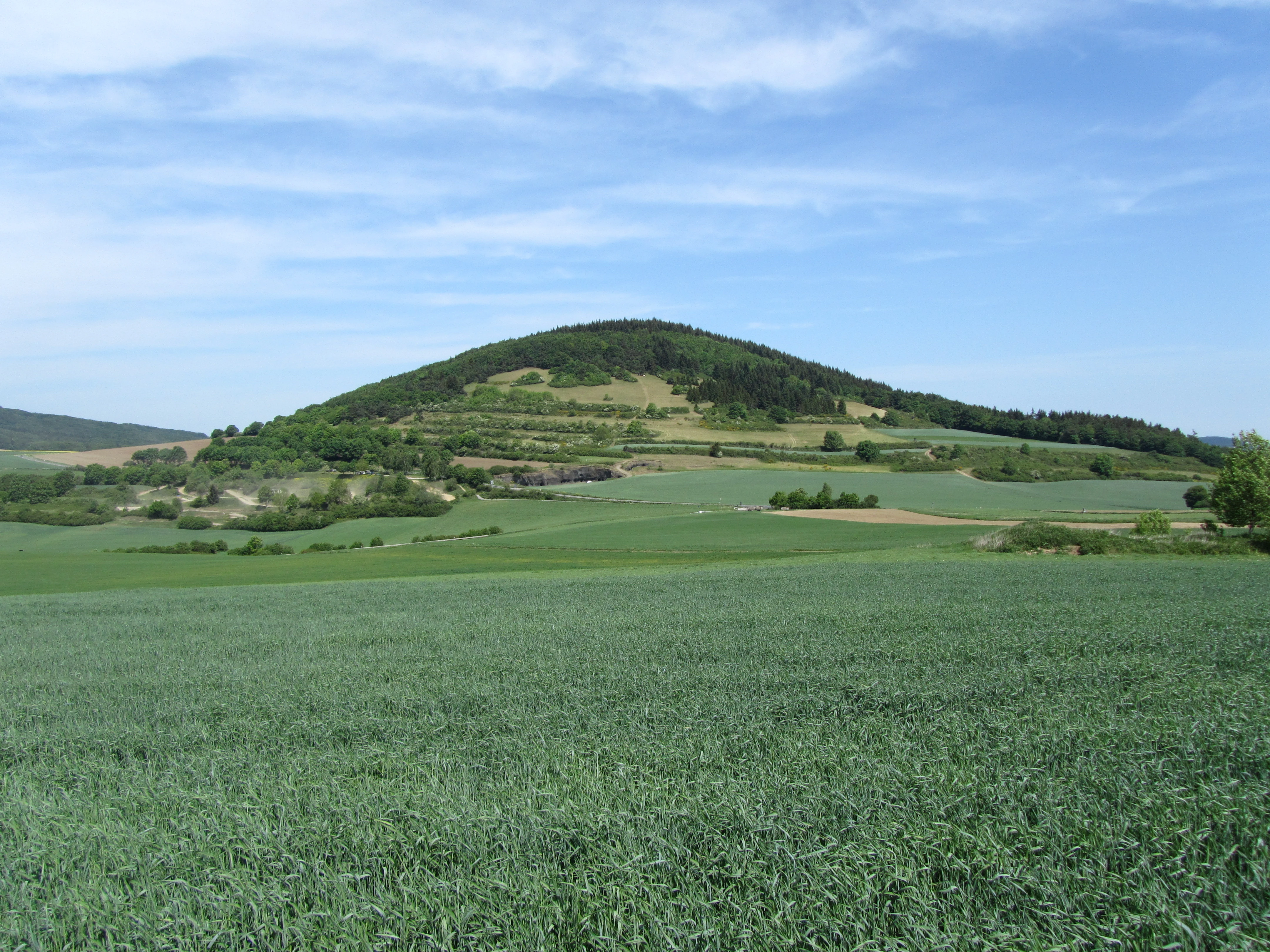
A wide landscape shot of a green volcanic hill, the Hochstein, rising above agricultural fields under a blue sky.
The Hochstein volcanic cone viewed from the southwest.

Hochstein Nature Reserve history and protected-area timeline

The Hochstein itself is a relic of the Eifel's volcanic past, formed during the geological phase that produced the broader Laacher Vulkane volcanic field long before human settlement. While the mountain itself is ancient in geological terms, its formal protection is a much more recent development in the history of the site.

In 1983, the core area around the volcano was designated as the Naturschutzgebiet Hochstein, placing its roughly 3.5 square kilometers under nature conservation status and giving it an established identity within the Rhineland-Palatinate protected-areas register. Only three years earlier, in 1980, the surrounding countryside had already been included in the extensive Rhein-Ahr-Eifel landscape protection area, embedding the Hochstein reserve within a much wider regional framework for protecting scenery, habitats, and rural character.

The mountain also carries a deeper cultural history tied to the legend of the Pfalzgräfin Genoveva of Brabant, who according to medieval tradition sought refuge in a cave on the northwestern flank of the Hochstein. This gave the cave its persistent name, Genovevahöhle or Hochsteinhöhle, and linked the geological monument to one of the most widely circulated folk legends of the German Middle Ages.

Hochstein Nature Reserve landscape and geographic character

Hochstein is a classic Vulkanberg of the Osteifel, a conical hill with gently rounded slopes that reflect its origin as a former volcanic vent. Although erosion has softened its profile over the millennia, the mountain still stands out clearly against the surrounding plateau as a recognizable volcanic cone within the Hohe Eifel highland.

The reserve sits at the interface between the volcanic Ettringer Vulkankuppen natural region to the north and east and the forested Nitz-Nette-Wald region to the west. This transitional position gives the protected area a varied relief: the central cone is interspersed with forested flanks and small valleys where brooks descend toward the Nette river system. The Kellbach arises just north of the mountain and the Segbach just south, both contributing to the Krufter Bach and ultimately to the Middle Rhine drainage.

The hill's position within the larger Laacher Vulkane volcanic field ties Hochstein visually and geologically to neighboring landmarks such as the Ettringer Vulkanberge and the broader volcanic uplands around Mayen. Forest cover dominates the slopes, creating a quiet, gently undulating landscape that contrasts with the more open agricultural plateau surrounding the mountain.

Hochstein Nature Reserve ecosystems, habitats, and plant life

The Hochstein reserve protects a representative example of Eifel volcanic upland habitats. The forested cone supports mixed woodland typical of the Osteifel, while the transition zones toward the surrounding lowlands contain semi-open habitats that fall under the broader Rhein-Ahr-Eifel landscape protection framework. Because the reserve overlaps with part of the Unteres Mittelrheingebiet bird protection area, the site also contributes to the conservation of bird species associated with the Middle Rhine valley and the wooded volcanic uplands.

The landscape mosaic around Hochstein, with its mix of closed forest, slopes, small stream valleys, and woodland edges, allows for a range of microhabitats on a relatively compact site. This is particularly relevant at the eastern edge of the Laacher Vulkane volcanic field, where forest habitat continuity matters for both resident species and migratory birds along the Rhine corridor.

The Kellbach to the north and the Segbach to the south shape the immediate ecological character of the reserve's lower flanks, adding small riparian zones that complement the woodland communities higher up the cone. Together with the geology of the volcanic bedrock and the long-established forest cover on the slopes, these features give Hochstein a clearly defined ecological identity within Rhineland-Palatinate's protected-area system.

Hochstein Nature Reserve wildlife and species highlights

Hochstein's woodlands support typical Eifel forest fauna associated with mixed deciduous and coniferous stands on volcanic substrate. The reserve's overlap with the Unteres Mittelrheingebiet bird protection area reflects its relevance for birdlife that depends on the wooded uplands along the Middle Rhine and the transition between forested slopes and open valley habitats.

Small stream valleys shaped by the Kellbach and Segbach add modest but ecologically meaningful riparian habitat around the base of the cone. The combination of mature forest, slope variation, and streamside zones creates opportunities for woodland birds, small mammals, and insect communities typical of the Volcanic Eifel.

Hochstein Nature Reserve conservation status and protection priorities

Hochstein's conservation value is rooted primarily in its protected status as a designated Naturschutzgebiet since 1983, anchored in the Rhineland-Palatinate register with the Common Database on Designated Areas entry 163713. The reserve safeguards a characteristic Vulkanberg together with much of its forested slopes, preserving both geological heritage and the woodland habitats that have long characterized the site.

Layered protection amplifies the site's significance. The mountain falls partly within the much larger Rhein-Ahr-Eifel landscape protection area, designated in 1980, which buffers the core reserve with a wider countryside-level protection framework spanning several hundred square kilometers. Additionally, part of Hochstein lies within the Unteres Mittelrheingebiet bird protection area, recognized under the European bird directive for its ornithological value, linking the local site to trans-regional conservation priorities along the Middle Rhine.

Together, status as a nature reserve, partial inclusion in a vast landscape protection area, and overlap with a designated bird protection area establish Hochstein as a small but well-integrated component of the regional conservation network of the eastern Eifel.

Hochstein Nature Reserve cultural meaning and human context

Hochstein's cultural identity is closely tied to the medieval legend of Genoveva of Brabant, the Pfalzgräfin whose story became one of the most widespread folk tales in German-speaking lands, later immortalized in plays, operas, and literary retellings. The cave known as the Genovevahöhle, also called Hochsteinhöhle, on the northwestern flank of the volcano is by tradition the place where she is said to have taken refuge, giving the otherwise ordinary geological feature a strong local and regional resonance.

In the local community of Ettringen, the mountain is still known by the dialectal name Kalberg, meaning bare or bald mountain, a name documented on a map from around 1809 when the volcano was referred to as the Forstberg. This layered naming history reflects how Hochstein has long been a recognizable local landmark, woven into everyday regional identity in the Volcanic Eifel.

Top sights and standout views in Hochstein Nature Reserve

Hochstein stands out as one of the defining Vulkanberge of the Osteifel, a rare protected example of an extinct volcano whose forested cone remains a clearly visible landmark above the Eifel plateau.

Best time to visit Hochstein Nature Reserve

Hochstein is most appealing in spring and early summer, when woodland flora on the slopes comes into bloom and birdlife in and around the Unteres Mittelrheingebiet bird protection area is most active. Autumn brings rich forest color across the volcanic uplands, while winter views can be especially clear from the surrounding plateau toward the cone. Visitor use of the site is generally low-key and tied to walking the forested slopes rather than structured tourism infrastructure, so seasonal choice mostly affects atmosphere and the chance to observe woodland and valley habitats at their seasonal peak.

Monthly climate preview

Examine long term weather by month variations and representative coordinate averages across Hochstein

Hochstein Climate Normals, Annual Temperature and Precipitation Profiles

Long term climate data for Hochstein maps measured monthly temperature swings alongside steady daily precipitation averages from 1991 to 2020. Detailed monthly normals provide deeper analytical context for evaluating regional weather patterns across the protected terrain.
Annual mean9 °C
0 °C19 °C
Jan
Feb
Mar
Apr
May13°
Jun16°
Jul19°
Aug18°
Sep14°
Oct
Nov
Dec
Warmest month
July

18.7 °C

Coolest month
January

0 °C

Wettest month
December

2.5 mm/day

Driest month
April

1.6 mm/day

Park location guide

Geography guide, regional context, and park location map for Hochstein Nature Reserve

Hochstein Nature Reserve park geography, regions, and map view in Germany

Understand where Hochstein Nature Reserve sits in Germany through a broader geographic reading of the surrounding landscape, nearby location context, and its mapped position within the national park landscape.

How Hochstein Nature Reserve fits into Germany

Germany is a federal republic in Western and Central Europe with a population of over 83 million across sixteen constituent states. It is Europe's largest economy by nominal GDP and a major global exporter and importer. The capital is Berlin, and the country borders Denmark, Poland, Czech Republic, Austria, Switzerland, France, Luxembourg, Belgium, and the Netherlands.

Wider geography shaping Hochstein Nature Reserve in Germany

Germany is located in Western and Central Europe, spanning 357,022 km². It borders Denmark to the north, Poland and the Czech Republic to the east, Austria and Switzerland to the south, and France, Luxembourg, Belgium, and the Netherlands to the west. The country has coastlines on the Baltic Sea and North Sea to the north, with the Alps located in the southern region.

Map view of Hochstein Nature Reserve

Use this park location map to pinpoint Hochstein Nature Reserve in Germany, understand its exact geographic position, and read its mapped placement within the surrounding landscape more clearly.

Pigeon | © OpenStreetMap contributors

Location context for Hochstein Nature Reserve

Rhineland-Palatinate

Visual reference collection showcasing the forested volcanic cone and terrain of the East Eifel reserve

Hochstein Photos and Volcanic Landscape Imagery

Examine detailed visual documentation of Hochstein to understand the topography, forest cover, and extinct volcanic features defining the reserve. Photographic records reveal the characteristic cone profile and protected environment within the broader Rhineland upland landscape.

A wide landscape shot of a green volcanic hill, the Hochstein, rising above agricultural fields under a blue sky.

Park atlas

Compare regional volcanic topography and connected conservation areas

Explore Other Parks Near Hochstein and Surrounding Protected Landscapes

Browse nearby national parks and protected areas located throughout the surrounding region to compare regional volcanic terrain. Expanding beyond Hochstein reveals connected conservation landscapes, forested highland reserves, and geological features across the Eifel.
Nature reserveRhineland-Palatinate
About 1.9 km away#1 closest

East

Nettetal Nature Reserve: Geography and Protected Boundaries in Rhineland-Palatinate

Steep-sided valley landscapes and biodiversity corridors.

Nettetal Nature Reserve offers a deep look into the geomorphology of a classic Kerbtal in Rhineland-Palatinate. This protected area along the Nette tributary showcases a rare density of contrasting terrains, from sun-exposed rock formations to damp valley floors, providing a clear window into regional conservation mapping.

Area
7.05 km²
Established
1986
Scope
Terrestrial
Water
Major water bodies
A horizontal watercolor painting showing a soft, stylized landscape of green rolling hills and volcanic peaks behind a line of pine trees and a calm body of water in the foreground.
Nature reserveRheinland-Pfalz
About 1.9 km away#2 closest

Southwest

Hochsimmer Nature Reserve: Volcanic Topography and Forested Highlands of the Eastern Eifel

A study of basaltic twin cones and protected regional wilderness

Hochsimmer is a well-defined volcanic cinder cone near the Mayen-Koblenz district, characterized by its twin-peak profile and expansive woodland canopy. This protected nature reserve anchors the local topography where the volcanic Eifel meets the Middle Rhine basin, offering an essential reference for understanding the geological and ecological structure of the Rhineland-Palatinate high country.

Area
2.491 km²
Established
1973
Relief
Mountain
Climate
Temperate
A watercolor painting showing a rocky, layered cliff face in the center, surrounded by green foliage, with rolling hills and a mountain range in the background against a white backdrop.
Protected areaRheinland-Pfalz
About 4.4 km away#3 closest

South

Mayener Grubenfeld: Protected Industrial Landscapes and Volcanic Terrain in Germany

A historic basalt mining district and vital bat hibernation hub

The Mayener Grubenfeld preserves deep traces of volcanic activity and industrial evolution, marked by porous basalt sheets and centuries of extraction. Today, the terrain consists of abandoned quarry pits, gallery systems, and dry grassland habitats that form a protected area of significant geological and ecological value within Rheinland-Pfalz.

Area
1.5 km²
Relief
Upland
Climate
Temperate
Access
Easy access
Watercolor painting of a calm lake with a shoreline of green trees and distant, soft-hued rolling hills in the background.
Nature reserveRheinland-Pfalz
About 5.8 km away#4 closest

Northeast

Naturschutzgebiet Laacher See: Volcanic Crater Lake and Protected Regional Landscape

Geographic overview of the Eifel volcanic caldera and nature reserve.

Naturschutzgebiet Laacher See is a significant nature reserve in the Eifel volcanic field, centering on a deep crater lake of great ecological importance. Its protected boundaries encompass surrounding volcanic crater slopes, providing a critical refuge for waterfowl and breeding birds throughout the year. This record details the unique terrain and regional landscape context of this primary Rhineland-Palatinate conservation site.

Area
21.04 km²
Established
1940
IUCN
IV
Nature reserveRhineland-Palatinate
About 7 km away#5 closest

Northwest

Lehrenkopf Nature Reserve: Mapped Volcanic Terrain and Regional Eifel Geography

Geological landscape and protected botanical site in Ahrweiler

Lehrenkopf stands as a compact nature reserve characterized by its 496-meter volcanic hill, which anchors the botanical and geological identity of the site. Spanning across the municipal territories of Kempenich and Brenk, this protected area serves as a focal point for regional conservation within the Eifel, emphasizing the preservation of rare wild plant species and the maintenance of distinct skyline features in the Ahrweiler district.

Area
0.35 km²
Established
1989
IUCN
IV
Relief
Mountain
Nature reserveRheinland-Pfalz
About 11 km away#6 closest

North

Bausenberg Nature Reserve: Geological Scoria Cone and Volcanic Landscape in Rhineland-Palatinate

Protected Eifel volcanic terrain and ancient earthwork geography.

Bausenberg serves as a protected window into eastern Eifel volcanism, showcasing a classic scoria cone and horseshoe-shaped crater profile. Located between Niederzissen and Waldorf, this 127-hectare reserve preserves critical lava-flow remnants and rare habitats, offering a deep look at the volcanic and human history shaped into the landscape of Rhineland-Palatinate.

Area
1.27 km²
Established
1981
Relief
Mountain
Climate
Temperate
Nature reserveRhineland-Palatinate
About 11 km away#7 closest

West

Wacholderheiden Raßberg und Heidbüchel: Protected Juniper Heathland in Rhineland-Palatinate

Mapping traditional Eifel bergheide landscapes

Located in the Arft municipality, this nature reserve protects two distinct sections of Raßberg and Heidbüchel. The area is defined by its characteristic juniper-dotted slopes that exemplify the rare mountain-heath ecosystems once common across the German uplands. This site serves as a vital anchor for regional habitat conservation within the broader Rhein-Ahr-Eifel landscape context.

Area
0.24 km²
Established
1981
Relief
Upland
Scope
Terrestrial
A watercolor painting showing a reddish-brown layered geological formation, likely a quarry or volcanic cliff, topped with trees, with softer green hills in the distance.
Nature reserveRhineland-Palatinate
About 11 km away#8 closest

Northeast

Nastberg Nature Reserve: Volcanic Geology and Protected Landscapes in Rhineland-Palatinate

Tracing volcanic fissures and scoria cone history in the Middle Rhine region

Nastberg represents a significant geological site within the Vulkanpark network. The nature reserve exposes complex layers of tuff and scoria, documenting a long history of explosive activity. With views extending across the Neuwied Basin toward the Westerwald and Hunsrück, this site offers deep insight into the regional volcanic geography of western Germany.

Relief
Mountain
Climate
Temperate
Access
Easy access
Scope
Terrestrial

Common questions about visiting, size, designation, and location context for Hochstein Nature Reserve

Hochstein Nature Reserve FAQs for park facts, access, geography, and protected area context

Find quick answers about Hochstein Nature Reserve, including protected-area facts, park geography, trail and visitor context, and how the park fits into its surrounding country and regional landscape.
MoriAtlas Explorer

Continue Your Protected Areas Search Across the Global Atlas

Deepen your exploration by continuing the structured search for national parks and protected areas worldwide. Utilize the comprehensive filtering capabilities to compare different conservation landscapes and refine your understanding of global park geography. Discover more about the distribution and characteristics of protected natural areas.

Global natural geography