Mori Atlas logo
Nature reserveHohes Kreuz

Examining the ecological significance and terrain of this forest island in central Germany.

Hohes Kreuz Nature Reserve and Protected Woodland Landscapes of the Thuringian Forest Region

(Naturschutzgebiet Hohes Kreuz)

Hohes Kreuz serves as a vital nature reserve situated on the edge of the Thuringian Forest, representing a concentrated refuge for mixed broadleaf woodland within an agricultural landscape. Spanning a Muschelkalk plateau, the site provides crucial structural complexity for mature forest species and breeding birds. This protected area illustrates the importance of small habitat patches in maintaining biodiversity across the regional geography of the Ilm district.

nature reserveNaturschutzgebietThuringian Forestbroadleaf forestoak-hornbeam forestMuschelkalk plateau

Hohes Kreuz

Nature reserve

Park overview

Structured park overview, official facts, and landscape profile for Hohes Kreuz

Hohes Kreuz park facts, protected area profile, and essential visitor context

Review the core facts for Hohes Kreuz, including designation, size, terrain, visitor scale, habitats, and operating context in one park-focused overview.

About Hohes Kreuz

Hohes Kreuz is a compact yet ecologically valuable nature reserve on the northern fringes of the Thuringian Forest, in central Germany. Located in the Ilm district northwest of Stadtilm, near the road linkage toward Wüllersleben, the reserve protects one of the surviving fragments of natural broadleaf woodland in a region otherwise dominated by farmland. Its modest size, just over ten hectares, belies its significance as a habitat island where forest-dependent flora and fauna can persist amid an intensively cultivated landscape.

Geologically, Hohes Kreuz rests on a Muschelkalk shelf, the characteristic shell limestone that defines much of Thuringia's hill country. The plateau surface is draped in loess, which together with the underlying limestone produces a mosaic of calcareous loamy soils, Parabraunerde, and patches of Pseudogley where drainage is restricted. The terrain slopes at only about five degrees, creating a stable, well-drained environment that supports a layered, mature forest community rather than rocky outcrops.

Ecologically, the reserve functions as a relic forest complex embedded within agricultural fields. This setting gives Hohes Kreuz a high conservation profile despite its small footprint: the woodland edge interfaces, the mix of soil types, and the regional climate of the low mountain landscape together create conditions for a distinctive blend of species. The reserve's official designation in 1961 reflects early recognition of its botanical and ornithological importance, and it remains a focus area for habitat and species management in the Ilm district.

Quick facts and research context for Hohes Kreuz

Hohes Kreuz is a 10.5 hectare nature reserve in the Ilm district of Thuringia, northwest of the town of Stadtilm near Wüllersleben. Designated in 1961 with the official identifier 058, it falls within the buffer zone of the Thuringian Forest and is registered in the World Database on Protected Areas under WDPA-ID 163751.

The reserve occupies a gently inclined Muschelkalk plateau covered with loess, hosting calcareous loam soils, Parabraunerde, and Pseudogley. Its woodland composition blends subcontinental and prealpine floristic elements, supporting oak-hornbeam communities with lime, wild service tree, sycamore maple, and bird cherry alongside shrubs such as hazel and red honeysuckle.

Protection and recognition

Documented management scope and official protected area records for Hohes Kreuz

Hohes Kreuz Protection Status and Terrestrial Conservation Details

Terrestrial conservation records for Hohes Kreuz establish the baseline protection status and management scope within international databases. Conservation researchers review these documented designation details to analyze habitat safeguards and administrative frameworks.

Protection details

Protection scope
Terrestrial
WDPA ID
163751
Park context

Deeper park guide and search-rich context for Hohes Kreuz

Hohes Kreuz history, landscape, wildlife, and travel context

Explore Hohes Kreuz through its history, landscape character, ecosystems, wildlife, conservation priorities, cultural context, and seasonal travel timing in a structured park guide built for atlas discovery and search intent.

Why Hohes Kreuz stands out

Hohes Kreuz is best known for preserving a small, ecologically rich patch of mixed broadleaf forest on the Muschelkalk foothills of the Thuringian Forest. Its particular significance comes from the unusual combination of subcontinental and prealpine floristic elements that thrive there, reflecting the regional climatic influence of the surrounding low mountain range. The reserve is also valued as a breeding ground for forest-edge and mature woodland bird species, including raptors such as goshawk, common buzzard, and red kite, alongside woodpeckers, warblers, and other songbirds that depend on intact, structurally diverse deciduous woodland.
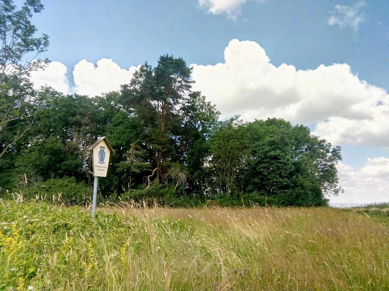
A nature reserve sign with a blue owl emblem stands in a grassy field in front of a dense line of trees under a blue sky with white clouds.
A nature reserve sign at the edge of the Hohes Kreuz forest area in Thuringia.

Hohes Kreuz history and protected-area timeline

Hohes Kreuz was placed under formal nature protection in 1961, becoming one of the early designated nature reserves of the Ilm district in Thuringia. Its establishment reflects the post-war German tradition of identifying and protecting surviving fragments of natural forest within heavily used agricultural landscapes.

The reserve has been continuously recognized as a Habitats/Species Management Area (IUCN Category IV), and it is registered internationally through the World Database on Protected Areas. Beyond its initial designation, the documented history of the site is closely tied to ongoing conservation efforts in the Thuringian Forest region, where small woodland reserves like Hohes Kreuz play a disproportionately important role in maintaining landscape connectivity and habitat diversity.

Hohes Kreuz landscape and geographic character

The landscape of Hohes Kreuz is shaped by its position on a Muschelkalk plateau at the edge of the Thuringian Forest. The underlying shell limestone gives the area its broadly level character, while a thin layer of loess smoothed over the plateau creates a gently inclined surface sloping at roughly five degrees. This subtle topography, combined with the alternating calcareous and loamy soil types, produces a stable setting for forest rather than the rocky cliffs or karst features sometimes associated with Muschelkalk terrain elsewhere in Thuringia.

What defines the visual character of Hohes Kreuz is its contrast with the surrounding land use. The reserve is a forested island set within an agricultural matrix, so the local landscape reads as alternating woodland blocks and open fields. Within the reserve, the terrain is forested and relatively uniform, allowing the forest interior to develop its full structural complexity without major topographic disruption.

Hohes Kreuz ecosystems, habitats, and plant life

Hohes Kreuz supports a forest ecosystem of notable floristic diversity for its size, driven by the unusual juxtaposition of subcontinental and prealpine plant communities that the regional climate of the Thuringian low mountain range makes possible. Species with subcontinental affinities, such as small-leaved lime, wild service tree, wayfaring viburnum-like shrubs, and field maple, grow alongside more montane elements like sycamore maple, mountain knapweed, and fox's groundsel.

Drier parts of the plateau are dominated by oak-hornbeam forest, with a tall canopy of sessile oak, small-leaved lime, wild cherry, Norway maple, wild service tree, silver birch, and hornbeam. The shrub layer below adds hazel and red honeysuckle, completing a multi-tiered woodland structure. Where water tables shift, soil conditions diversify into Parabraunerde and Pseudogley, adding microhabitat variation within the small reserve footprint and supporting a correspondingly rich understory.

Hohes Kreuz wildlife and species highlights

The woodland structure of Hohes Kreuz provides nesting and foraging habitat for a varied community of forest birds. Raptors breeding in the reserve include the common buzzard, northern goshawk, and red kite, taking advantage of the mature canopy and edge structure for hunting perches and nest sites.

The reserve also supports woodland specialists and edge-loving songbirds such as the long-eared owl, great spotted woodpecker, golden oriole, marsh tit, willow tit, wood warbler, and icterine warbler. The presence of this bird assemblage underscores the conservation value of the site: even a small forest fragment, when structurally intact and well-connected to the broader Thuringian Forest, can host a remarkable density of mature-forest and forest-edge species.

Hohes Kreuz conservation status and protection priorities

Conservation significance at Hohes Kreuz centers on its role as a habitat and species management area within a fragmented agricultural-forest mosaic. Classified as IUCN Category IV, the reserve is managed to preserve the integrity of its oak-hornbeam forest communities and the dependent bird and plant species that the regional microclimate supports.

The site's importance is amplified by its small size: as a 10.5 hectare remnant forest embedded within farmland, it serves as a refuge for species that cannot survive in open or intensively managed surroundings. Its protection since 1961 has helped maintain habitat continuity in the Ilm district, and its inclusion in international databases such as the WDPA reflects recognition of its contribution to broader Thuringian biodiversity conservation.

Hohes Kreuz cultural meaning and human context

Hohes Kreuz sits within the Ilm district, a region historically shaped by the interplay between forestry and agriculture on the lower slopes of the Thuringian Forest. Small woodland patches like this one are part of the traditional land-use mosaic of central Thuringia, where communities long balanced timber production, grazing, and field cultivation across Muschelkalk terrain.

The name Hohes Kreuz itself, "High Cross," references local landmarks common in the rolling hill country between the Thuringian Forest and the Ilm valley, reflecting a long-standing pattern of small religious or boundary markers at elevated points in the landscape. The protected area thus stands within a region where natural and cultural history are tightly interwoven.

Top sights and standout views in Hohes Kreuz

Hohes Kreuz's chief highlight is its concentration of conservation value within a very small footprint: less than eleven hectares of oak-hornbeam forest sheltering a rich community of woodland birds and a botanical mix that combines subcontinental and prealpine elements. The combination of Muschelkalk geology, loess soils, and climatic influence from the Thuringian Forest gives the site an ecological profile that stands out in the surrounding farmland-dominated region.

Another distinguishing feature is the reserve's long conservation history, dating back to its 1961 designation and its integration into international recognition through the World Database on Protected Areas. Hohes Kreuz exemplifies how small forest remnants in central Germany contribute meaningfully to landscape-scale biodiversity.

Best time to visit Hohes Kreuz

Spring and early summer are generally the most rewarding times to experience forest reserves like Hohes Kreuz, when deciduous trees are in full leaf, the understory is most floristically visible, and breeding birds are active and vocal. Late spring is particularly suitable for observing woodland songbirds and raptors nesting within the canopy.

Autumn brings the warm color display typical of mixed oak-hornbeam forest, with the addition of hazel and other shrub-layer species in fruit. Winters tend to be quieter, with reduced bird activity and bare-canopy views that make the woodland structure easier to read on the ground. Because the reserve is small and managed primarily for habitat protection rather than high visitor traffic, visits tend to be most rewarding for observers who appreciate quiet, structurally diverse forest rather than dramatic landscape vistas.

Monthly climate preview

Long-term representative temperature and precipitation averages for Hohes Kreuz

Hohes Kreuz Climate Normals and Monthly Temperature Rhythms

Representative coordinate measurements reveal the annual temperature and precipitation rhythm across Hohes Kreuz from long-term NASA data records. Reviewing the complete monthly profile provides detailed baseline climate normals without relying on live forecasts.
Annual mean9 °C
-1 °C19 °C
Jan-1°
Feb
Mar
Apr
May13°
Jun17°
Jul19°
Aug19°
Sep14°
Oct
Nov
Dec
Warmest month
July

18.9 °C

Coolest month
January

-1 °C

Wettest month
July

2.5 mm/day

Driest month
April

1.3 mm/day

Park location guide

Geography guide, regional context, and park location map for Hohes Kreuz

Hohes Kreuz park geography, regions, and map view in Germany

Understand where Hohes Kreuz sits in Germany through a broader geographic reading of the surrounding landscape, nearby location context, and its mapped position within the national park landscape.

How Hohes Kreuz fits into Germany

Germany is a federal republic in Western and Central Europe with a population of over 83 million across sixteen constituent states. It is Europe's largest economy by nominal GDP and a major global exporter and importer. The capital is Berlin, and the country borders Denmark, Poland, Czech Republic, Austria, Switzerland, France, Luxembourg, Belgium, and the Netherlands.

Wider geography shaping Hohes Kreuz in Germany

Germany is located in Western and Central Europe, spanning 357,022 km². It borders Denmark to the north, Poland and the Czech Republic to the east, Austria and Switzerland to the south, and France, Luxembourg, Belgium, and the Netherlands to the west. The country has coastlines on the Baltic Sea and North Sea to the north, with the Alps located in the southern region.

Map view of Hohes Kreuz

Use this park location map to pinpoint Hohes Kreuz in Germany, understand its exact geographic position, and read its mapped placement within the surrounding landscape more clearly.

Pigeon | © OpenStreetMap contributors

Location context for Hohes Kreuz

Thuringia

Visual exploration of the Muschelkalk plateau and woodland habitats in Thuringia

Hohes Kreuz Photos, Scenery, and Protected Forest Landscapes

Visual records capture the distinctive forest island structure and limestone terrain of Hohes Kreuz across changing seasonal conditions. Photographic documentation reveals the ecological transition between mature deciduous woodland and the surrounding agricultural lowlands.

A nature reserve sign with a blue owl emblem stands in a grassy field in front of a dense line of trees under a blue sky with white clouds.

Park atlas

Discover related reserves, forest patches, and regional natural areas

Exploring Parks Near Hohes Kreuz and Surrounding Protected Landscapes

Browsing protected areas near Hohes Kreuz reveals the broader network of woodland reserves and habitat islands scattered across the Thuringian low mountain region. Comparing adjacent forest tracts provides essential context on regional biodiversity, shell limestone geology, and connected conservation landscapes.
Nature reserveThuringia
About 5.5 km away#1 closest

Southwest

Willinger Berg Nature Reserve: Exploring the Geography and Forested Terrain of the Ilm-Saale-Platte

A prominent muschelkalk limestone outlier in Thuringia

Willinger Berg stands out for its double-peaked silhouette and geological significance as a Zeugenberg. The 83.8 hectare nature reserve includes protected beech forests and karst features that define the slopes above the surrounding villages. This study traces its role as a regional landmark and its position within the complex watershed of the Ilm and Unstrut basins.

Area
0.838 km²
Relief
Mountain
Climate
Temperate
Scope
Terrestrial
A soft watercolor illustration showing gentle, rolling green hills and a small patch of wildflowers in the foreground on a white background.
Protected areaThuringia
About 8.4 km away#2 closest

East

Großer Kalmberg Protected Area: Geography and Landscape of the Ilm-Saale-Platte

Examining the asymmetric summit and calcareous habitats in central Thuringia.

Großer Kalmberg rises as a focal point of the Ilm-Saale-Platte, offering a clear view into the geological history of the region. This summit integrates pine-forested slopes with protected dry grasslands and rocky outcrops, creating a complex mosaic of terrain that characterizes this part of Thuringia.

Area
2.64 km²
Established
1999
Relief
Mountain
Climate
Temperate
Nature reserveIlm-Kreis
About 12 km away#3 closest

West

Gottesholz Nature Reserve: Mapping the Protected Landscapes of Ilm-Kreis, Thuringia

A study of shell-limestone woodland geography

Gottesholz serves as an essential nature reserve in Ilm-Kreis, defined by its porous shell-limestone bedrock and rich, diverse vegetation. This detailed view covers the physical landscape, the strict forest reserve status, and the ecological markers that define this distinctive central German site.

Area
0.593 km²
Established
1961
IUCN
IV
Nature reserveThuringia
About 13 km away#4 closest

Southwest

Veronikaberg Nature Reserve: Protected Muschelkalk Ridge and Forest Landscapes in Thuringia

Geographic overview of the southern Reinsberge range.

Veronikaberg functions as a critical nature reserve at the southeastern edge of the Ohrdrufer Platte. The landscape is defined by its Muschelkalk geology, which supports a unique microclimate for beech and yew forests. This record details the park boundaries and the terrain transitions that characterize this significant conservation site in central Germany.

Area
1.161 km²
Established
1961
Relief
Mountain
Water
No major water
A horizontal watercolor painting depicting a landscape with soft, rolling hills in the background, a band of mixed forest with hints of autumn foliage in the midground, and a winding stream flowing through wetland grasses in the foreground.
Nature reserveThuringia
About 14 km away#5 closest

South

Pennewitzer Teiche und Unteres Wohlrosetal Nature Reserve: Thuringian Wetland Geography

A dense mosaic of historic ponds, moor woodlands, and framing stream valleys.

Located in Thuringia, this nature reserve is defined by an extraordinary density of aquatic habitats. The terrain features historic pond groups and flooded forest pits linked by brook valleys. This protected area serves as an essential example of the interplay between cultural pond construction and natural wetland ecosystems in central Germany.

Area
4.246 km²
Established
2004
IUCN
IV
A soft watercolor illustration of a pond landscape with green reeds in the foreground, calm water in the midground, and distant rolling hills in the background.
Nature reserveIlm-Kreis
About 15 km away#6 closest

Southwest

Ilmenauer Teichgebiet: Wetland Landscape and Protected Nature Reserve Atlas

Mapped pond system and geographic terrain in Ilm-Kreis

The Ilmenauer Teichgebiet nature reserve is defined by its six interconnected ponds, which create a significant wetland complex on the eastern edge of Ilmenau. Anchored by the Grosser Teich and supported by a gypsum basin, this area preserves both the history of medieval fish farming and critical habitats for waterbirds and amphibians, offering a unique look at the regional geography of central Thuringia.

Area
0.58 km²
Established
2002
IUCN
IV
Relief
Lowland
Protected landscapeThuringia
About 16 km away#7 closest

Northeast

Landschaftsschutzgebiet Mittleres Ilmtal: Protected Landscape Geography and Map Discovery

Thuringia regional atlas and protected area profile

Gain insight into the diverse topography of Landschaftsschutzgebiet Mittleres Ilmtal, which spans roughly 150 square kilometers. This protected landscape is characterized by its dramatic shifts from Buntsandstein forests in the Tannrodaer Sattel to the elevated Muschelkalk escarpments, offering a detailed case study in German mid mountain geography.

Area
150 km²
Relief
Upland
Climate
Temperate
Access
Access unknown
Nature reserveWeimarer Land
About 22 km away#8 closest

East

Seeteich Blankenhain Nature Reserve: Geographic Map and Protected Area Context

Wetland landscape situated in the Weimarer Land district

Seeteich Blankenhain is a distinct nature reserve in Germany, characterized by its historic pond and surrounding moist lowland ecosystems. This site remains a focal point for ecological research and conservation, offering a layered landscape of reed zones and woodland that supports a diverse bird community. Its presence within the regional geography of Weimarer Land highlights the importance of small-scale wetland preservation in the Thuringian landscape.

Established
1991
Relief
Lowland
Access
Access unknown
Scope
Terrestrial

Common questions about visiting, size, designation, and location context for Hohes Kreuz

Hohes Kreuz FAQs for park facts, access, geography, and protected area context

Find quick answers about Hohes Kreuz, including protected-area facts, park geography, trail and visitor context, and how the park fits into its surrounding country and regional landscape.
MoriAtlas Explorer

Continue Your Protected Areas Search Across the Global Atlas

Deepen your exploration by continuing the structured search for national parks and protected areas worldwide. Utilize the comprehensive filtering capabilities to compare different conservation landscapes and refine your understanding of global park geography. Discover more about the distribution and characteristics of protected natural areas.

Global natural geography