Mori Atlas logo
Nature reserveHohlsteinhöhle

Examining the ecological boundaries and limestone fissure systems within the Eggegebirge uplands

Hohlsteinhöhle Nature Reserve: Geological Karst Features and Protected Subterranean Landscapes

(Naturschutzgebiet „LIP-061 Hohlsteinhöhle")

The Hohlsteinhöhle nature reserve represents a critical subterranean habitat located in the Eggegebirge ridge of North Rhine-Westphalia, Germany. This protected limestone fissure cave features specialized karst geology and functions as a vital hibernation refuge for regional bat populations. Mapping the site reveals its deep connection to the Plänerkalk limestone belt, offering a focused look at the intersection of protected ecological zones and unique cave-dwelling fauna.

cavekarst landscapelimestone fissure cavebat hibernation sitenature reserveFFH site

Hohlsteinhöhle

Nature reserve

Park overview

Structured park overview, official facts, and landscape profile for Hohlsteinhöhle

Hohlsteinhöhle park facts, protected area profile, and essential visitor context

Review the core facts for Hohlsteinhöhle, including designation, size, terrain, visitor scale, habitats, and operating context in one park-focused overview.

About Hohlsteinhöhle

Hohlsteinhöhle lies in the northern Eggegebirge, where the long ridge of this low mountain range approaches the Teutoburg Forest and forms one of the characteristic geological transition zones of eastern Westphalia. The cave itself formed in the Plänerkalk, a sequence of Cretaceous limestones deposited during the Turonian stage, and its development along natural fracture lines in the rock has produced a typical fissure cave system. The cave passage runs roughly westwards from its entrance, descending over a rubble-strewn floor before opening into two chambers that contain stalactite and stalagmite formations in their harder-to-reach interior sections.

With a total length of around 200 metres and a maximum interior height of 47 metres, the Hohlsteinhöhle is not a large system on a global scale but is among the more significant caves of Ostwestfalen, together with the Lukenloch and the Bielsteinhöhle at Bauernkamp, all three carving out the same Cretaceous limestone belt. The entrance, perched on the western flank of the Hohlestein hill at roughly 420 metres above sea level, sits a few hundred metres below the 433.2-metre summit. From the outside, the entrance is sealed by a four-metre-high metal grille, an unusual but deliberate feature that reflects the cave's contemporary function rather than its discovery history.

The location, roughly two kilometres east-northeast of Kohlstädt, places the cave on the edge of the Senne region and within easy reach of the long-distance trails that run across the Eggegebirge. Its position between two of North Rhine-Westphalia's most prominent low mountain ridges the Eggegebirge to the south and the Teutoburg Forest to the north means the surrounding landscape combines forested ridges, karst exposures, and small upland valleys. The cave's setting, geomorphology, and conservation role together define its significance within the Lippe district's network of small but ecologically focused protected areas.

Quick facts and research context for Hohlsteinhöhle

Hohlsteinhöhle is a fissure cave (Klufthöhle) developed in Cretaceous Plänerkalk limestone, situated on the western slopes of the Hohlestein summit at about 420 metres above sea level in the northern Eggegebirge, North Rhine-Westphalia. The cave is roughly 200 metres long with a maximum interior height of 47 metres, and consists of an entrance passage grading into two deeper chambers that contain dripstone formations in their less accessible sections.

The site carries both German and EU nature-protection status: it is designated as the Naturschutzgebiet LIP-061 and as the Natura 2000 FFH area DE-4119-305. Public access is limited and the entrance is sealed with a grille to prevent disturbance, particularly during the bats' hibernation period.

Protection and recognition

Documented terrestrial protection scope and international recognition records

Hohlsteinhöhle Protection Status and Natura 2000 Recognition Data

Terrestrial protection status records for Hohlsteinhöhle outline formal conservation boundaries and recognized management frameworks. Natura 2000 designations establish verified international recognition sources for this protected natural area.

International recognition

Protection details

Protection scope
Terrestrial
Transboundary protection
No
Park context

Deeper park guide and search-rich context for Hohlsteinhöhle

Hohlsteinhöhle history, landscape, wildlife, and travel context

Explore Hohlsteinhöhle through its history, landscape character, ecosystems, wildlife, conservation priorities, cultural context, and seasonal travel timing in a structured park guide built for atlas discovery and search intent.

Why Hohlsteinhöhle stands out

Hohlsteinhöhle is best known as one of the most important bat hibernation sites in eastern Westphalia, hosting several bat species and supporting a cave beetle subspecies (Choleva septentrionis sokolowskii) found nowhere else in the world. The combination of restricted public access, gridded entrance, and dense winter bat usage gives the cave an unusually strong conservation profile for a relatively small fissure cave, and its status as both a nature reserve and a Natura 2000 site underlines its recognition within European habitat protection frameworks.
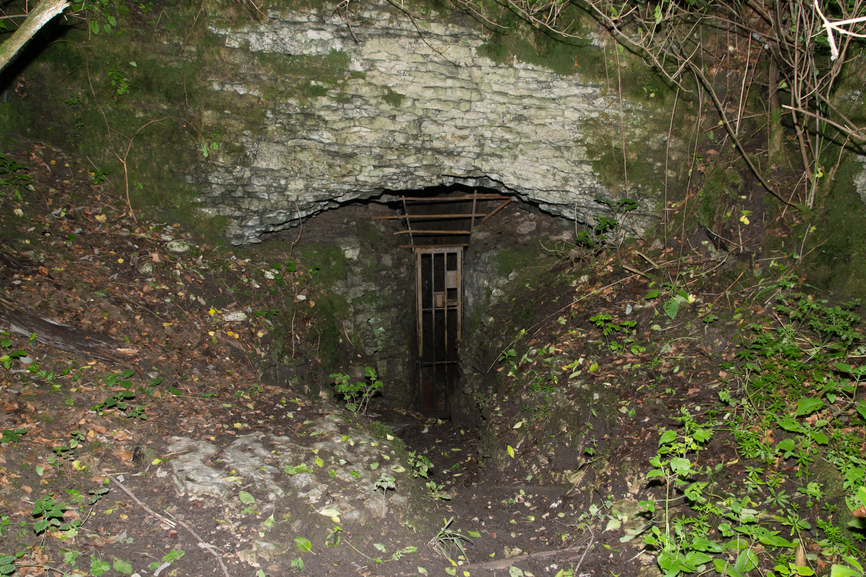
A cave entrance with a metal gate set into a rocky hillside, surrounded by moss, fallen leaves, and small green plants.
The gated entrance to Hohlsteinhöhle cave set into a moss-covered limestone rock face.

Hohlsteinhöhle history and protected-area timeline

The Hohlsteinhöhle was first explored as early as 1779, making it one of the longer-documented caves in eastern Westphalia and linking it to an early period of natural history interest in the Eggegebirge. Early-twentieth-century regional writing, including Georg Heese's 1926 multi-part series "Das Geheimnis der Hohlstein-Höhle" published in the Lippische Landeszeitung, brought the cave briefly into wider local attention, and subsequent cave-science literature, such as Hans Morlo's overview of the caves of Lippe and the Paderborn region, placed it within the broader karst and speleological record of Westphalia.

In the modern era, the cave's history has been shaped primarily by conservation designations rather than by continued exploration. It was declared a Naturdenkmal and Naturschutzgebiet, and later incorporated into the Natura 2000 network as FFH area DE-4119-305, placing it under the protection framework of the Landesamt für Natur, Umwelt und Klima Nordrhein-Westfalen. The installation of the entrance grille reflects a deliberate management decision to limit human disturbance so that the cave can continue to function as an undisturbed hibernation site for bats, effectively redirecting its history from an object of exploration toward a strictly protected habitat.

Hohlsteinhöhle landscape and geographic character

The Hohlsteinhöhle sits within the northern segment of the Eggegebirge, a long, narrow low mountain ridge in eastern Westphalia that extends in a southeasterly to northwesterly direction. The surrounding terrain is forested and dissected, with the cave itself tucked into the western flank of the Hohlestein hill, roughly 250 metres west of the 433.2-metre summit at approximately 420 metres above sea level. From the entrance area, the land drops away towards the meadows and villages at the edge of the Senne, while the ridge continues to link south into the broader Eggegebirge massif and north into the Teutoburg Forest.

The most distinctive surface features in the immediate area are the karst exposures inherited from the Plänerkalk limestone in which the cave developed. The same limestone belt hosts the Lukenloch and the Bielsteinhöhle at Bauernkamp, giving this stretch of the Eggegebirge a clear cave-karst character rather than the rounded hills typical of the nearby sandstone areas. Small upland valleys, mixed forest stands, and exposed limestone outcrops give the cave's broader setting a varied and structurally interesting surface landscape, even though the protected area itself is a compact subterranean site rather than an extensive scenic reserve.

Hohlsteinhöhle ecosystems, habitats, and plant life

Ecologically, the Hohlsteinhöhle is important as a near-natural subterranean habitat. The fissure system developed in Plänerkalk provides a stable microclimate with constant humidity and temperature, conditions that support a specialized cave fauna largely cut off from surface disturbance. The cave's environment is therefore quite different from the surrounding Eggegebirge forests: where the surface supports mixed woodland and upland meadow communities, the cave interior represents a dark, humid, low-energy ecosystem dependent on organic input from outside, mainly in the form of bat droppings and occasional animal remains.

The narrow constriction inside the cave, followed by the two larger chambers, produces a gradation from a moderately ventilated entrance zone to deeper, more sheltered interior conditions. Stalactite and dripstone formations in the back portions of the chambers indicate ongoing deposition, while the rubble-strewn entrance passage reflects rockfall and surface erosion processes acting on the same limestone. The whole system is small in overall volume but ecologically sensitive: any change in airflow, humidity, or disturbance regime can affect the bat populations and the specialized invertebrate community that depend on it.

Hohlsteinhöhle wildlife and species highlights

The Hohlsteinhöhle is most significant for its bat population, which uses the cave almost year-round and especially as a winter roost. Recorded species include the whiskered bat (Bartfledermaus), the brown long-eared bat (Braunes Langohr), the Natterer's bat (Fransenfledermaus), the Daubenton's bat (Wasserfledermaus), the greater mouse-eared bat (Großes Mausohr), and the pond bat (Teichfledermaus). The greater mouse-eared bat is the most numerous winter resident, with counts of up to 35 individuals recorded in the cave.

A particularly notable element of the cave's fauna is the bat cave beetle Choleva septentrionis sokolowskii, a subspecies described from this site and known globally only from the Hohlsteinhöhle. Both larvae and adults of this beetle feed on dead bats, bat droppings, and food remains, tying the invertebrate community closely to the bat population. The presence of this endemic beetle makes the cave a globally important site for cave-dwelling invertebrates as well as for chiropteran conservation, and is a key reason for the strict access restrictions and the protective grille at the entrance.

Hohlsteinhöhle conservation status and protection priorities

Conservation management is the defining feature of the Hohlsteinhöhle today. The cave is protected as the Naturschutzgebiet LIP-061 and as the Natura 2000 FFH site DE-4119-305, placing it within both the German nature reserve system and the European Union's network of protected habitats. Public access is restricted by design, and a four-metre-high grille seals the entrance to limit human entry, reduce vandalism, and protect hibernating bats from disturbance during the most sensitive season of the year.

The cave's conservation value rests on three pillars: its role as a bat hibernation site, its importance for cave-dwelling invertebrates including the globally unique beetle subspecies, and its significance as a representative example of an Upper Cretaceous limestone karst system. Within the Lippe district's network of nature reserves, the Hohlsteinhöhle stands out as a small but ecologically disproportionate site, and its protected status under both federal and EU frameworks ensures that management continues to prioritize minimal disturbance and long-term habitat stability.

Hohlsteinhöhle cultural meaning and human context

The Hohlsteinhöhle has limited but distinct cultural connections to the Lippe region. Its long documentation history, with written accounts going back to 1779 and local press attention in the form of Georg Heese's 1926 series in the Lippische Landeszeitung, ties the cave to a wider regional interest in karst caves across the Eggegebirge and the Paderborn area. Speleological writing by Hans Morlo and the broader reference work of Hubert Trimmel further anchored the cave within the German cave-science tradition.

In the contemporary landscape, the cave sits on the edge of the municipality of Schlangen, near the village of Kohlstädt, in an area where small-scale farming, forestry, and protected-area management coexist. While there is no prominent folklore or built heritage attached specifically to the cave, its protected status and its inclusion in regional literature mean that it forms part of the identity of the northern Eggegebirge as an area of karst landscape and natural heritage within eastern Westphalia.

Top sights and standout views in Hohlsteinhöhle

The Hohlsteinhöhle combines a clearly defined geological setting, a protected ecological function, and a globally unique faunal element within a compact site. Its Plänerkalk fissure system links it geologically to the Lukenloch and the Bielsteinhöhle at Bauernkamp, while its status as both a Naturschutzgebiet and a Natura 2000 FFH area underscores its official ecological importance.

Most distinctively, the cave supports a winter bat population that includes the greater mouse-eared bat and an endemic beetle subspecies known only from this site, secured behind a gridded entrance that limits human disturbance, ensuring the Hohlsteinhöhle remains a small but disproportionately important protected area in the Eggegebirge landscape.

Best time to visit Hohlsteinhöhle

Because public access to the cave itself is restricted for conservation reasons, the Hohlsteinhöhle is not a typical destination for casual visits. For those interested in the surrounding Eggegebirge landscape and the surface context of the cave, late spring through early autumn is generally the most comfortable time to explore the surrounding trails and karst terrain, when forest paths are accessible, weather conditions favor outdoor walking, and bat activity above ground is at its seasonal peak.

During the winter months, the cave is most ecologically active due to the hibernating bat population, and that is precisely the season when any approach should be avoided in order to avoid disturbing the bats. The cave is therefore best appreciated indirectly: by visiting the broader Eggegebirge scenery in milder months and recognizing that the cave itself functions as a quiet, protected refuge during the cold season.

Monthly climate preview

Track monthly temperature variations and precipitation averages at Hohlsteinhöhle

Hohlsteinhöhle Climate and Weather by Month: Long-Term Temperature Normals

Long-term representative records outline the measured annual temperature progression and daily precipitation rates across twelve distinct intervals at Hohlsteinhöhle. Examining the complete monthly climate dataset provides deeper insight into baseline environmental patterns and average meteorological distributions.
Annual mean9 °C
1 °C18 °C
Jan
Feb
Mar
Apr
May13°
Jun16°
Jul18°
Aug18°
Sep14°
Oct
Nov
Dec
Warmest month
July

18.1 °C

Coolest month
January

0.5 °C

Wettest month
December

2.6 mm/day

Driest month
April

1.6 mm/day

Park location guide

Geography guide, regional context, and park location map for Hohlsteinhöhle

Hohlsteinhöhle park geography, regions, and map view in Germany

Understand where Hohlsteinhöhle sits in Germany through a broader geographic reading of the surrounding landscape, nearby location context, and its mapped position within the national park landscape.

How Hohlsteinhöhle fits into Germany

Germany is a federal republic in Western and Central Europe with a population of over 83 million across sixteen constituent states. It is Europe's largest economy by nominal GDP and a major global exporter and importer. The capital is Berlin, and the country borders Denmark, Poland, Czech Republic, Austria, Switzerland, France, Luxembourg, Belgium, and the Netherlands.

Wider geography shaping Hohlsteinhöhle in Germany

Germany is located in Western and Central Europe, spanning 357,022 km². It borders Denmark to the north, Poland and the Czech Republic to the east, Austria and Switzerland to the south, and France, Luxembourg, Belgium, and the Netherlands to the west. The country has coastlines on the Baltic Sea and North Sea to the north, with the Alps located in the southern region.

Map view of Hohlsteinhöhle

Use this park location map to pinpoint Hohlsteinhöhle in Germany, understand its exact geographic position, and read its mapped placement within the surrounding landscape more clearly.

Pigeon | © OpenStreetMap contributors

Location context for Hohlsteinhöhle

North Rhine-Westphalia

Visual reference material capturing karst formations, forest terrain, and protected habitats.

Hohlsteinhöhle Photos and Limestone Scenery across the Eggegebirge Landscape

Visual documentation provides a clear window into the rugged limestone terrain and forested uplands surrounding Hohlsteinhöhle. Examining field photography helps researchers interpret the distinct surface geology and protected habitat features of the region.

A cave entrance with a metal gate set into a rocky hillside, surrounded by moss, fallen leaves, and small green plants.

Park atlas

Compare nearby regional reserves, karst geology, and connected forest habitats.

Exploring Other Parks Near Hohlsteinhöhle and Surrounding Protected Landscapes

Visitors reviewing Hohlsteinhöhle can browse nearby national parks and protected areas sharing similar upland geography. Expanding the regional view helps compare adjacent karst formations and connected conservation zones across the wider landscape.
A watercolor painting showing a stylized landscape with gentle, rolling hills in soft green, yellow, and purple tones, with simple evergreen trees in the midground.
Nature reserveNordrhein-Westfalen
About 7.6 km away#1 closest

Northwest

Hohe Warte Nature Reserve: Sandstone Landscapes of the Teutoburg Forest

Protected heath and woodland mosaic in Nordrhein-Westfalen

Hohe Warte stands as a significant protected nature reserve, encompassing a diverse mosaic of heather, birches, and dry sandstone terrain. This area at the edge of the Teutoburg Forest illustrates the ongoing transition between open pasture landscapes and regenerating woodland. The site provides a valuable look into small-scale habitat management and the geological features shaping the local Nordrhein-Westfalen environment.

Area
0.06 km²
Established
2006
IUCN
IV
A soft watercolor illustration featuring rolling green hills, a small grouping of trees on the right, and open grassy terrain on a white background.
Protected areaNordrhein-Westfalen
About 11 km away#2 closest

West

Senne mit Teutoburger Wald: Protected Habitat and Regional Geography Atlas

Heathland and forest ecosystems in North Rhine-Westphalia

This protected area presents a unique geographic profile, merging expansive lowland heath and dune systems with the wooded slopes of the Teutoburg Forest. Its distinct ecological gradient and significant size make it a critical site for habitat conservation, bird protection, and study of transition zones between sandy plains and mountain ridges.

Area
153.597 km²
Established
2001
Relief
Mixed relief
Climate
Temperate
Nature reserveNordrhein-Westfalen
About 13 km away#3 closest

Southwest

Lippeniederung zwischen Bad Lippspringe und Mastbruch: A Protected Floodplain Landscape

Nature reserve geography and river valley conservation in Paderborn, Germany.

Lippeniederung zwischen Bad Lippspringe und Mastbruch encompasses a specialized floodplain corridor along the Lippe river. This site highlights the importance of managing small-scale riverine meadows and aquatic transition zones within the broader, heavily used agricultural geography of North Rhine-Westphalia.

Area
1.59 km²
Established
1966
IUCN
IV
Relief
Lowland
A watercolor painting showing a green landscape with a winding river and distant hills under a light pink sky.
Protected landscapeKreis Paderborn
About 17 km away#4 closest

Southwest

Landschaftsschutzgebiet Fließgewässer und Auen: Regional Protected Landscape Overview

Riverine floodplain corridors and valley habitats in Paderborn

This protected landscape in Kreis Paderborn sustains essential habitat connectivity along river valleys including the Lippe and Beke. Its design features a fragmented network of sixteen sub-areas, showcasing how floodplain vegetation, wet meadows, and riparian corridors function within an urban-adjacent environment.

Area
9.583 km²
Established
1999
Relief
Lowland
Scope
Terrestrial
A soft watercolor painting of a river flowing through a gentle green valley with scattered trees and a small stone bridge, set against a pale yellow and pink sky.
Nature reserveNordrhein-Westfalen
About 17 km away#5 closest

Northeast

Marpetal mit Passade und Zufluesse: Nature Reserve and Stream Valley Geography

Protected riparian landscapes in the district of Lippe

Marpetal mit Passade und Zufluesse consists of an 89-hectare nature reserve that safeguards the ecological integrity of small river valleys. Its terrain, defined by the Passade and Marpe streams, connects with adjacent protected lands to maintain a continuous corridor of floodplain and slope habitats within the rural Westphalian landscape.

Area
0.889 km²
Established
2005
A horizontal watercolor painting depicting a soft-toned landscape with scattered evergreen trees and undulating, sandy terrain under a light sky.
Nature reserveNordrhein-Westfalen
About 17 km away#6 closest

West

Moosheide Nature Reserve: Mapping the Ancient Inland Dune Landscapes of Nordrhein-Westfalen

Protected heathland and spring-fed habitat geography.

Moosheide provides a focused look at the geomorphology of the western Senne region. This reserve protects some of the oldest inland dunes in northwestern Germany, alongside a rare juxtaposition of dry sandy grasslands and groundwater-dependent stream valleys that support high species diversity.

Area
4.427 km²
Established
1994
IUCN
IV
Relief
Lowland
A soft, horizontal watercolor painting showing a winding stream flowing through a green valley with gentle hills and trees in the background.
Nature reserveNordrhein-Westfalen
About 18 km away#7 closest

South

Naturschutzgebiet Schmittwassertal: A Protected Nature Reserve in the Paderborn District

Mapping brook corridors and calcareous grassland landscapes in Westphalia.

Naturschutzgebiet Schmittwassertal represents a fragmented yet ecologically vital nature reserve in Nordrhein-Westfalen. The area encompasses 53.6 hectares of stream-cut valleys and limestone-influenced slopes. This atlas entry details the mosaic of habitats ranging from alder-lined brook corridors to nutrient-poor Borstgrasrasen and semi-dry calcareous grasslands, highlighting its function as a connected biological corridor.

Area
0.536 km²
Established
2014
Relief
Upland
Climate
Temperate
A watercolor painting of a wetland landscape with soft green hills, trees, and a winding waterway.
Nature reserveNorth Rhine-Westphalia
About 21 km away#8 closest

Northwest

Kipshagener Teiche Nature Reserve: A Protected Wetland Sanctuary in North Rhine-Westphalia

Geographic analysis of historic bogs and managed wetland habitats

Kipshagener Teiche is a small but essential nature reserve in the Senne region, characterized by a distinct mosaic of ponds, transitional bog, and wet heath. Originally protected in 1937, the site serves as a vital record of wetland biodiversity and recovery in western Germany. Its varied topography, featuring dune-based pine plantations and swamp forest, offers a precise look at the intersection of conservation and landscape management in a human-influenced region.

Area
0.113 km²
Established
1970
IUCN
IV

Common questions about visiting, size, designation, and location context for Hohlsteinhöhle

Hohlsteinhöhle FAQs for park facts, access, geography, and protected area context

Find quick answers about Hohlsteinhöhle, including protected-area facts, park geography, trail and visitor context, and how the park fits into its surrounding country and regional landscape.
MoriAtlas Explorer

Continue Your Protected Areas Search Across the Global Atlas

Deepen your exploration by continuing the structured search for national parks and protected areas worldwide. Utilize the comprehensive filtering capabilities to compare different conservation landscapes and refine your understanding of global park geography. Discover more about the distribution and characteristics of protected natural areas.

Global natural geography