Mori Atlas logo
Wildlife reserveHoly Cross Wilderness

Mapping the high-country terrain and glacial basin networks of the Sawatch Range

Holy Cross Wilderness Protected Area: Geographic Atlas and Alpine Landscape Context

The Holy Cross Wilderness encompasses over 120,000 acres of high-altitude terrain in central Colorado, representing a signature protected landscape within the Sawatch Range. This atlas entry details its dramatic geography, characterized by sharp ridgelines, deep glacial valleys, and a dense concentration of alpine lakes. Users can trace the boundaries of this protected area to understand the interplay between its subalpine forests, rocky tundra, and the iconic 14,000-foot peaks that define the regional geography.

wilderness areaalpine landscapeRocky Mountainsfourteenersubalpine forestalpine lakes

Holy Cross Wilderness

Wildlife reserve

Park overview

Structured park overview, official facts, and landscape profile for Holy Cross Wilderness

Holy Cross Wilderness park facts, protected area profile, and essential visitor context

Review the core facts for Holy Cross Wilderness, including designation, size, terrain, visitor scale, habitats, and operating context in one park-focused overview.

About Holy Cross Wilderness

The Holy Cross Wilderness is one of the more scenically distinctive high-country wilderness areas in Colorado. Designated in 1980 under the U.S. Wilderness System, it covers about 122,797 acres within the San Isabel and White River national forests. Its geography stretches across Eagle, Lake, and Pitkin counties, putting it within reach of several well-known Colorado mountain communities, including Vail, Leadville, Minturn, Avon, Edwards, and Eagle.

The wilderness occupies a central position in the heart of the Colorado Rockies. Its terrain includes high ridges of the Sawatch Range, deep glacial valleys, alpine basins, and rolling subalpine forests. Much of the landscape sits at elevation, with the wilderness anchored by the 14,005-foot Mount of the Holy Cross, from which it takes its name. The mountain's dramatic snow-filled couloirs are visible from Notch Mountain and other surrounding ridges, creating one of the most photographed natural features in the American West.

Recreation within the wilderness centers on its extensive trail network, which exceeds 160 miles and links alpine lakes such as Mystic Island Lake, Lake Charles, Beaver Lake, Turquoise Lake, Fancy Lake, Grouse Lake, the Tuhare Lakes, and Blodgett Lake. Trails also provide routes to Half Moon Pass and to Mount of the Holy Cross itself. Visitors come for backpacking, day hiking, and backcountry solitude, with trailheads situated at a range of elevations and access points.

The wilderness fits within a broader network of Rocky Mountain protected landscapes and is valued both for its scenic character and its ecological diversity. While it draws significant recreational use, the area retains a strong sense of remoteness and offers a classic Colorado alpine wilderness experience in close proximity to the Vail resort corridor and other Front Range gateways.

Quick facts and research context for Holy Cross Wilderness

Holy Cross Wilderness is a U.S. Wilderness Area located in central Colorado across parts of Eagle, Lake, and Pitkin counties. Designated in 1980 and managed by the U.S. Forest Service, the wilderness spans portions of the San Isabel and White River national forests and totals roughly 122,797 acres. The area contains more than 160 miles of marked trails and surrounds the 14,005-foot Mount of the Holy Cross, from which it takes its name. The nearest major community is Vail, with other gateway towns including Leadville, Minturn, Avon, Edwards, and Eagle.

Protection and recognition

Review documented terrestrial protection scope and official designation records.

Holy Cross Wilderness Protection Status and International Recognition Facts

Holy Cross Wilderness maintains a documented terrestrial protection scope within its designated natural boundary. Official records outline the established conservation framework and international recognition details associated with the terrain.

Protection details

Protection scope
Terrestrial
Transboundary protection
No
Park context

Deeper park guide and search-rich context for Holy Cross Wilderness

Holy Cross Wilderness history, landscape, wildlife, and travel context

Explore Holy Cross Wilderness through its history, landscape character, ecosystems, wildlife, conservation priorities, cultural context, and seasonal travel timing in a structured park guide built for atlas discovery and search intent.

Why Holy Cross Wilderness stands out

The wilderness is best known for Mount of the Holy Cross, a 14,005-foot fourteener whose snow-filled north-face couloirs form the distinctive cross shape that has long drawn pilgrims, photographers, and outdoor travelers to the area. Notch Mountain, its neighbor, is the classic vantage point from which this natural cross can be viewed. Beyond the mountain itself, the area is recognized for its dense concentration of alpine lakes, including Mystic Island Lake, Turquoise Lake, Beaver Lake, and the Tuhare Lakes, many connected by popular hiking trails. A combination of rugged Sawatch Range terrain, glacial cirques, high meadows, and extensive trail mileage makes the wilderness a signature destination for backcountry recreation in central Colorado.
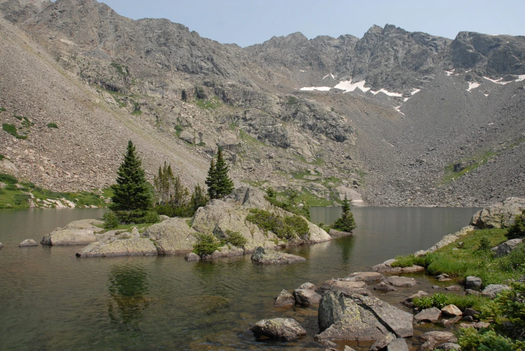
A calm, clear lake with a rocky island featuring several small evergreen trees in the center, surrounded by steep, craggy mountain slopes containing patches of snow.
Mystic Island Lake nestled within the rugged, high-altitude terrain of the Holy Cross Wilderness.

Holy Cross Wilderness history and protected-area timeline

The Holy Cross Wilderness was formally designated in 1980 as part of the U.S. Wilderness System, building on a longer history of informal appreciation for the Mount of the Holy Cross region. The mountain itself had long captured public attention because of the cross-shaped pattern formed by snow in its north-face couloirs, attracting visitors, photographers, and explorers throughout the 19th and 20th centuries.

With the establishment of the wilderness in 1980, the area received formal federal protection across portions of the San Isabel and White River national forests. The designation consolidated roughly 122,797 acres under wilderness management, preserving its character from commercial development and motorized use. Since that time, the U.S. Forest Service has managed the area as a designated wilderness, emphasizing non-motorized recreation, trail-based access, and preservation of natural conditions.

Over the decades, the wilderness has seen a steady increase in visitation, particularly as backcountry recreation has grown in popularity throughout Colorado. Trailheads and routes around Mount of the Holy Cross, Notch Mountain, and the high lake basins attract both experienced backpackers and casual hikers. The wilderness has also experienced a recurring pattern of visitor emergencies involving hikers unaccustomed to high-altitude alpine conditions, leading local authorities and the Forest Service to emphasize preparation, risk awareness, and adequate equipment on wilderness trips.

Holy Cross Wilderness landscape and geographic character

The Holy Cross Wilderness occupies a dramatic slice of central Colorado's high country. Its terrain reflects the classic patterns of the Sawatch Range and surrounding Rocky Mountain systems, with sharp ridgelines, deep glaciated valleys, broad basins, and lingering alpine tundra above treeline.

The signature feature of the landscape is Mount of the Holy Cross, a 14,005-foot peak that gives the wilderness its identity. The mountain's north face is carved by couloirs that, when filled with snow, form a cross-shaped pattern. Notch Mountain, located to the north of Mount of the Holy Cross, provides the traditional and most celebrated vantage point overlooking this feature.

Beyond the central peak, the wilderness contains a dense network of glacial features. Cirques, U-shaped valleys, moraines, and high alpine basins shape much of the topography. The wilderness holds numerous alpine lakes, including Mystic Island Lake, Lake Charles, Beaver Lake, Turquoise Lake, Fancy Lake, Grouse Lake, the Tuhare Lakes, Treasure Vault Lake, and Blodgett Lake. These water bodies sit in basins framed by rocky ridges, talus slopes, and in some cases forest cover. Lower elevations within the wilderness include subalpine forests of spruce and fir, while the highest elevations transition into open rock and tundra.

Holy Cross Wilderness ecosystems, habitats, and plant life

Ecologically, the Holy Cross Wilderness reflects the typical zonation of central Colorado's Rocky Mountain ecosystems. Lower elevations support coniferous forests dominated by spruce and fir species typical of the Colorado subalpine zone, with montane forest types at the lower margins. Mid-elevation slopes include a mix of forested slopes, avalanche chutes, and open meadows.

Above treeline, the wilderness transitions into alpine tundra, where hardy grasses, sedges, and cushion plants survive in a short growing season dominated by snow cover for much of the year. Glacial lakes and clear, cold streams contribute to the hydrology of the area, while meadows and basin wetlands provide seasonal moisture for wildlife and plant communities.

The wilderness sits in close ecological association with adjoining national forest lands, allowing for relatively intact wildlife movement across a large landscape. The combination of forest cover, alpine habitat, and water resources creates a diverse ecological setting within a relatively compact geographic area. While not as famous for biodiversity as some lower-elevation parks, the wilderness provides a representative slice of high-country Colorado ecological character.

Holy Cross Wilderness wildlife and species highlights

Wildlife in the Holy Cross Wilderness reflects the broader fauna of Colorado's central Rocky Mountains. The mix of subalpine forest, alpine meadows, and rugged high-country terrain supports a variety of mammal and bird species adapted to elevation and seasonal conditions.

Typical mammals in the area include species associated with Colorado alpine and subalpine zones, ranging from elk, mule deer, and bighorn sheep in higher elevations to black bears, mountain lions, and small forest mammals in the wooded zones. Marmots and pikas are characteristic residents of the talus and tundra habitats above treeline.

Avian life in the wilderness includes species typical of high-country Colorado habitats. Raptors, including hawks and eagles, hunt over the open ridges and meadows, while white-tailed ptarmigan and other alpine-adapted birds occupy the tundra zones. Lower forest elevations host additional songbird and woodpecker species common to the region's spruce-fir forests.

Holy Cross Wilderness conservation status and protection priorities

The Holy Cross Wilderness is protected under the U.S. Wilderness System, a designation that emphasizes preservation of natural conditions, restriction of motorized and mechanized use, and protection of wilderness character in perpetuity. Designated in 1980 and managed by the U.S. Forest Service, the wilderness benefits from the long-term legal protections associated with wilderness designation.

The wilderness forms part of a broader landscape of national forest land in central Colorado, including portions of both the San Isabel and White River national forests. This broader setting helps connect the wilderness to surrounding wildland habitat and supports ecological processes that extend beyond its formal boundary.

The area's conservation value is closely tied to its high-elevation ecosystems, including alpine tundra, glacial lakes, subalpine conifer forests, and montane habitats that would be vulnerable to development pressures without formal protection. Its proximity to major Colorado resort areas and transportation corridors makes the wilderness designation particularly important for preserving backcountry conditions and ecological integrity in an otherwise heavily visited part of the state.

Holy Cross Wilderness cultural meaning and human context

The mountains of the Holy Cross Wilderness carry a distinctive cultural resonance rooted in the symbolism of Mount of the Holy Cross. Long before the area received wilderness designation, the cross-shaped snow pattern on the mountain's north face attracted curious travelers, artists, photographers, and religious pilgrims, becoming one of the more recognizable natural landmarks of the American West.

The broader region around the wilderness includes a strong outdoor recreation culture associated with Colorado's central mountains. Nearby communities such as Leadville, Minturn, Avon, Edwards, Eagle, and Vail have long histories tied to mining, ranching, and more recently, ski and resort tourism. Today, the wilderness is woven into this regional identity, serving as a backcountry complement to the more developed resort corridor of the Vail Valley.

Top sights and standout views in Holy Cross Wilderness

The Holy Cross Wilderness offers a concentrated showcase of central Colorado's alpine character. Its most recognized feature is the iconic cross-shaped snow pattern on Mount of the Holy Cross, visible from Notch Mountain and other surrounding vantage points. The wilderness also showcases classic Sawatch Range scenery, including glacial cirques, high ridges, dense subalpine forest, and extensive alpine lake basins connected by a well-developed trail network.

The combination of major trail mileage, numerous named lakes, dramatic fourteener terrain, and easy access from several Colorado mountain communities makes the wilderness a strong all-around destination. Whether the focus is on summiting a fourteener, exploring backcountry lakes, or simply absorbing high-country scenery, the area delivers a complete Colorado wilderness experience within a relatively compact protected footprint.

Best time to visit Holy Cross Wilderness

The Holy Cross Wilderness is best experienced during Colorado's summer and early autumn months, when snow has melted from most trails and high passes, and alpine wildflowers are in bloom. This window typically offers the most accessible conditions for backpacking, day hiking, and lake exploration, and provides the clearest views of Mount of the Holy Cross and surrounding ridges.

Late spring and early summer can still hold significant snowpack at higher elevations, especially around Mount of the Holy Cross itself and across alpine tundra, which can complicate travel and limit safe route choices. Winter brings deep snow and extreme conditions that make most wilderness travel difficult and suitable only for experienced and well-prepared backcountry users. Fall tends to be quieter, with cooler temperatures and the first dustings of snow returning to the high peaks, gradually transforming the cross-shaped couloirs back into their most recognizable winter appearance.

Monthly climate preview

Long-term representative elevation records for temperature and precipitation rhythms

Holy Cross Wilderness Climate Normals and Measured Monthly Weather Patterns

Representative coordinates record distinct annual temperature ranges alongside measured monthly precipitation values across the high-elevation terrain. Complete twelve-month records provide detailed long-term averages for analyzing annual meteorological cycles.
Annual mean-1 °C
-12 °C13 °C
Jan-12°
Feb-12°
Mar-8°
Apr-3°
May
Jun
Jul13°
Aug11°
Sep
Oct
Nov-7°
Dec-12°
Warmest month
July

12.7 °C

Coolest month
January

-12.5 °C

Wettest month
April

2.2 mm/day

Driest month
June

1.1 mm/day

Park location guide

Geography guide, regional context, and park location map for Holy Cross Wilderness

Holy Cross Wilderness park geography, regions, and map view in United States of America

Understand where Holy Cross Wilderness sits in United States of America through a broader geographic reading of the surrounding landscape, nearby location context, and its mapped position within the national park landscape.

How Holy Cross Wilderness fits into United States of America

The United States of America is a federal presidential republic and one of the world's largest countries by area and population. It consists of 50 states across a vast territory spanning multiple time zones, with its capital in Washington, D.C. and largest city in New York City. The nation has a diverse economy, influential political system, and significant cultural and military presence globally.

Wider geography shaping Holy Cross Wilderness in United States of America

The United States occupies a vast territory in North America, bordered by Canada to the north and Mexico to the south. The 48 contiguous states stretch from the Atlantic to the Pacific Ocean, while Alaska occupies the northwestern region and Hawaii is an archipelago in the Pacific. The country encompasses diverse terrain including the Rocky Mountains, Appalachian Mountains, Great Plains, and extensive river systems.

Map view of Holy Cross Wilderness

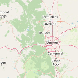
Use this park location map to pinpoint Holy Cross Wilderness in United States of America, understand its exact geographic position, and read its mapped placement within the surrounding landscape more clearly.

Pigeon | © OpenStreetMap contributors

Location context for Holy Cross Wilderness

Colorado
Recorded earthquake history

Review Recorded Earthquake History for the Holy Cross Wilderness

Examine the historical collection of seismic events documented near the Holy Cross Wilderness. This MoriAtlas dataset organizes USGS records by location and magnitude to provide an objective look at the seismic history within this portion of the Colorado Rocky Mountains.

Holy Cross Wilderness Earthquake History

Catalogued events

4 events

Strongest magnitude

Magnitude 3.4

Most recent event

Aug 21, 2012

This history includes earthquakes recorded inside the park or within 50 km of its borders

Visual exploration of Rocky Mountain terrain, alpine lakes, and high country habitats

Holy Cross Wilderness Photos and Scenic Landscape Views

Visual documentation provides a clear window into the rugged Sawatch Range terrain, glacial valleys, and subalpine forests defining Holy Cross Wilderness. Photographic records help researchers and visitors examine high-country topography, snow-carved couloirs, and protected alpine habitats across the region.

A calm, clear lake with a rocky island featuring several small evergreen trees in the center, surrounded by steep, craggy mountain slopes containing patches of snow.

Park atlas

Compare adjacent Sawatch Range high country and connected Rocky Mountain wilderness areas

Other Parks Near Holy Cross Wilderness and Surrounding Protected Landscapes

Browse nearby protected areas sharing the rugged terrain, glacial valleys, and high-altitude alpine character of Holy Cross Wilderness. Extending the geographic review across the surrounding Rocky Mountain region reveals broader patterns in high-country conservation and terrain.
Watercolor painting of a serene mountain landscape featuring rolling hills, coniferous trees, and a lake in the foreground, rendered in light pastel tones.
Protected landscapeColorado
Park boundaries overlap#1 closest

Southeast

San Isabel National Forest: Geographic Overview and Protected Mountain Landscape Atlas

Central Colorado alpine terrain and designated wilderness areas

Spanning eleven counties in central Colorado, San Isabel National Forest serves as a cornerstone of the Southern Rocky Mountains. The forest landscape is dominated by the Sawatch and Sangre de Cristo ranges, offering a unique atlas of alpine tundra, dense coniferous forests, and high-altitude peaks that define the character of the region. This protected area provides a vital habitat and a vast, rugged environment characterized by volcanic formations like the Spanish Peaks and glacial geological features.

Area
4,533.42 km²
Established
1902
Relief
Mountain
Climate
Alpine
A horizontal watercolor painting showing layers of pale green and soft pink mountain ridges behind a foreground of simple green and purple evergreen tree shapes.
Wildlife reserveColorado
3 km away#2 closest

South

Mount Massive Wilderness: A Protected Alpine Landscape in the Colorado Sawatch Range

High-altitude wilderness geography and Continental Divide terrain.

Mount Massive Wilderness represents a critical protected landscape in the central Colorado Rockies, encompassing glacially carved valleys, alpine tundra, and the second-highest peak in the state. This wilderness area provides a window into the rugged vertical relief and subalpine ecosystems that define the high-altitude geography surrounding Leadville, anchored by the iconic Sawatch Range and Continental Divide.

Area
123.6 km²
Established
1980
IUCN
Ib
Relief
Mountain
Wildlife reserveColorado
13 km away#3 closest

Northeast

Eagles Nest Wilderness: Alpine Geography and Protected Landscape of the Colorado Gore Range

High-mountain protected area in the White River National Forest

Spanning the southern Gore Range, Eagles Nest Wilderness represents a core protected landscape in Colorado characterized by high-elevation peaks, glacial cirque lakes, and extensive backcountry trail networks. Its geography bridges the gap between deep coniferous forests and exposed alpine tundra, maintaining significant ecological and historical value within the mountainous terrain of Eagle and Summit Counties.

Area
546.79 km²
Established
1976
IUCN
Ib
Relief
Mountain
A soft watercolor painting of a mountain landscape with rolling green hills in the foreground and layered, pale purple peaks in the distance.
Wildlife reservePitkin County
About 13 km away#4 closest

South

Hunter-Fryingpan Wilderness: Mapped Protected Geography in the Central Rocky Mountains

High-altitude wilderness area in Pitkin County, Colorado

Hunter-Fryingpan Wilderness encompasses approximately 82,000 acres of rugged terrain near the continental divide. This protected area acts as a headwaters sanctuary for the Fryingpan River and Hunter Creek, defined by its steep granite ridges, subalpine meadows, and clusters of pristine alpine lakes. Understanding its geography reveals the stark, glaciated character of the central Colorado Rockies.

Area
331.95 km²
Established
1978
IUCN
Ib
Relief
Mountain
A soft watercolor illustration depicting a simplified, layered landscape of rolling hills and distant mountains in shades of light green, pale yellow, and soft pink.
Protected areaColorado
18 km away#5 closest

East

Pike National Forest: Protected Mountain Landscapes and Regional Geography in Central Colorado

Granite peaks, montane forests, and diverse alpine terrain

Spanning from the rolling foothills of the Front Range to the high alpine summits of the Rocky Mountains, Pike National Forest is a significant protected area defined by its unique Pikes Peak granite bedrock and deep river-carved canyons. This analysis provides a structured look at its expansive wilderness boundaries, drainage basins, and the vertical transitions that characterize this vital central Colorado highland.

Area
4,478.27 km²
Established
1892
Relief
Mountain
Climate
Alpine
A watercolor painting showing purple and white mountain peaks rising above green rolling hills and meadows in a wide panoramic format
Protected areaColorado
56 km away#6 closest

East

Mount Evans Wilderness: Alpine Landscapes and Protected Geography in Colorado

Glacial cirques and high-altitude wilderness ecosystems.

Mount Evans Wilderness offers a premier look at the Colorado Front Range, defined by its dramatic relief, sheer cliff lines, and extensive glacial history. This entry examines the wilderness as a protected zone that transitions from montane forests to tundra, providing a reference for high-elevation mountainous geography within the United States.

Area
301.09 km²
Established
1980
IUCN
Ib
Relief
Mountain
Protected areaColorado
58 km away#7 closest

Southwest

Raggeds Wilderness: Geographic Profile and Protected Area Mapping for the Elk Mountains

High altitude wilderness terrain in west-central Colorado

Raggeds Wilderness encompasses over 65,000 acres of protected high-country terrain in the Elk Mountains. This atlas record provides a detailed look at the park, covering its dramatic vertical transitions from deep forest drainages to jagged peaks and its function as a major node in the regional wilderness network.

Area
264.64 km²
Established
1980
IUCN
Ib
Relief
Mountain
Protected landscapeColorado
About 64 km away#8 closest

East

White River National Forest: Mapping the Protected Landscapes and High Country of Central Colorado

Regional geography, wilderness boundaries, and mountain terrain data

Spanning from the high alpine tundra of the Sawatch Range to the volcanic plateaus of the Flat Tops, White River National Forest represents a significant protected area in the American West. This detail presents the geographic footprint, forest landscape, and complex mountain terrain that define this vital Colorado territory.

Area
9,251 km²
Established
1902
Relief
Mountain
Climate
Alpine

Common questions about visiting, size, designation, and location context for Holy Cross Wilderness

Holy Cross Wilderness FAQs for park facts, access, geography, and protected area context

Find quick answers about Holy Cross Wilderness, including protected-area facts, park geography, trail and visitor context, and how the park fits into its surrounding country and regional landscape.
MoriAtlas Explorer

Continue Your Protected Areas Search Across the Global Atlas

Deepen your exploration by continuing the structured search for national parks and protected areas worldwide. Utilize the comprehensive filtering capabilities to compare different conservation landscapes and refine your understanding of global park geography. Discover more about the distribution and characteristics of protected natural areas.

Global natural geography