
Mori Atlas logo
Nature reserveHolzhauser Bruch

Understanding the wetland forest and meandering Werre river habitats in Nordrhein-Westfalen

Holzhauser Bruch Nature Reserve: A Detailed Geographic Map of Protected Riverine Landscapes

(Naturschutzgebiet Holzhauser Bruch)

Holzhauser Bruch represents a significant protected area within the Nordrhein-Westfalen region, defined by its complex mosaic of lowland bog, swamp woodland, and riparian meadows. The reserve centers on a distinctively meandering section of the Werre river, where steep eroding banks and sediment bars create a structurally diverse corridor. This atlas entry provides a factual overview of the terrain, from the saturated valley floor to the drier beech-oak forest slopes along the valley rim.

lowland forestswamp woodlandlowland bogriparian habitatmeandering riverWerra valley
Stylized vector illustration of a forest surrounding a river leading to a mountain range with a visible waterfall.

Holzhauser Bruch

Nature reserve

Park overview

Structured park overview, official facts, and landscape profile for Holzhauser Bruch

Holzhauser Bruch park facts, protected area profile, and essential visitor context

Review the core facts for Holzhauser Bruch, including designation, size, terrain, visitor scale, habitats, and operating context in one park-focused overview.

About Holzhauser Bruch

Holzhauser Bruch is a small protected nature area in the Lippe district of North Rhine-Westphalia, located within the municipal territory of Bad Salzuflen. It occupies a stretch of the Werre river valley where the watercourse forms a pronounced meander, flanked by forested lowland bog on one side and the slope of the surrounding terrain on the other. The reserve was established in 2002 and is identified under the designation LIP-045 within the North Rhine-Westphalian nature protection system.

The defining feature of the area is the contrast between the wet valley floor and the drier upland. The lower parts of the reserve sit on a Niedermoor, a lowland peat substrate that supports wetland forest types such as alder swamp woodland and floodplain forest. The transition to the higher, drier terrain brings in beech-oak mixed forest, so that within a small area the landscape moves from saturated bog woodland through wet meadows and reedbeds up to a dry sandy ridge. The Werre itself, with its curved channel, sand and gravel banks, eroding steep banks, and fringe of riparian shrubs and tall herbs, adds further structural diversity.

The reserve lies between the settlements of Leopoldshöhe, Lage, and Bad Salzuflen, surrounded largely by agricultural land and small communities such as Sand and Alt-Holzhausen. It borders the Werre valley nature reserve Werreniederung und Haferbach to the southwest and the Heipker See reserve to the west, placing it within a chain of small protected sites that together conserve a significant portion of the Werre river landscape. Despite its modest 40-hectare size, Holzhauser Bruch contributes disproportionately to habitat connectivity in this densely settled region of eastern Westphalia.

Protection and recognition

Examine official protected area records and international recognition data for Holzhauser Bruch

Holzhauser Bruch Protection Status and Designated Conservation Records

Holzhauser Bruch conservation records compile official protected area data, management scope, and international recognition sources into a single reference. Structured protection metrics provide clear insight into the official governance framework assigned to this natural landscape.

Protection details

WDPA ID
329448
Park context

Deeper park guide and search-rich context for Holzhauser Bruch

Holzhauser Bruch history, landscape, wildlife, and travel context

Explore Holzhauser Bruch through its history, landscape character, ecosystems, wildlife, conservation priorities, cultural context, and seasonal travel timing in a structured park guide built for atlas discovery and search intent.

Why Holzhauser Bruch stands out

Holzhauser Bruch is best known for its wooded lowland bog site (Niedermoorstandort) and its pronounced meander section of the Werre river. The reserve is notable for combining swamp and floodplain forest with the steep slope of the valley edge and a near-natural river course fringed by alder-dominated riparian woodland. This compact mosaic of fen forest, wet meadow, reedbed, and upland beech-oak woodland on the valley rim is the defining ecological signature of the protected area.
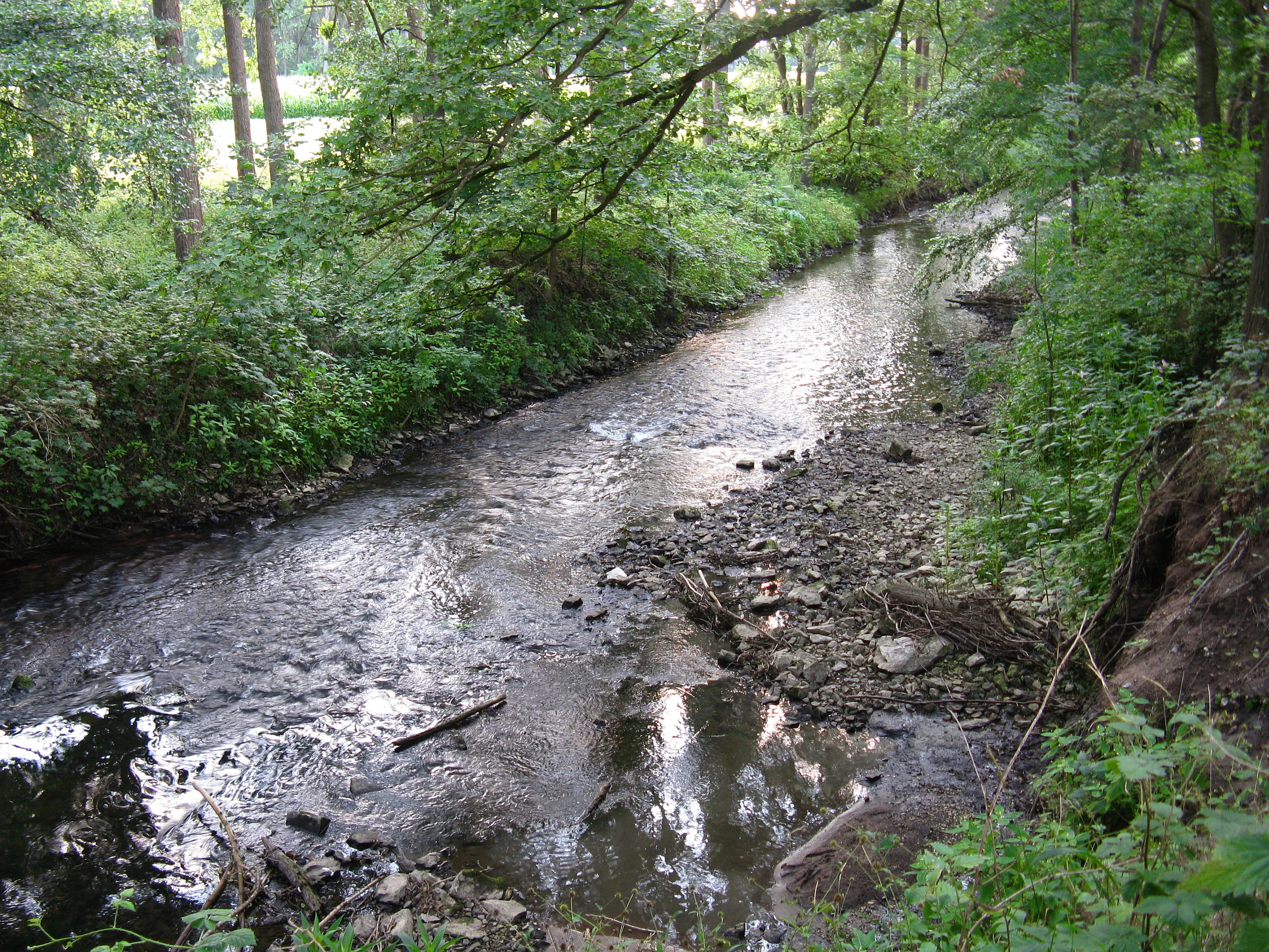
A narrow, shallow river flowing through a dense forest with exposed rocky banks in a nature reserve.
The Werre River flowing through the lush greenery of the Holzhauser Bruch nature reserve.

Holzhauser Bruch history and protected-area timeline

Holzhauser Bruch was formally designated as a nature reserve (Naturschutzgebiet) in 2002, under the oversight of the Lippe district administration (Kreis Lippe). Its protection reflects the broader German effort to conserve remaining fragments of near-natural lowland river systems and their associated wetland forests in heavily populated regions. The designation brought the area identified as LIP-045 into the state's formal nature protection framework and aligned it with the surrounding network of reserves along the Werre valley.

The reserve's modern boundaries have been shaped by both ecological value and infrastructure pressures. To the south and east, agricultural land and the settlements of Sand and Alt-Holzhausen border the protected site, and planned road development along a new alignment of the Bundesstraße 239, intended as a bypass for Holzhausen between Lage and the A2 junction near Herford, has been identified as a future pressure on the surrounding landscape. The reserve's formal establishment can be understood in part as a protective measure securing the wetland forest and meandering river section from such developments, while recognizing the site's role within the chain of Werre valley reserves.

Holzhauser Bruch landscape and geographic character

The landscape of Holzhauser Bruch is shaped by the Werre river valley and the contrast between its wet floor and the drier upland that frames it. The Werre runs along the western side of the reserve in a strongly meandering course, with pronounced curves, gravel and sand banks within the channel, and steep eroding banks along its outer bends. These steep sections, combined with reedbeds and tall-herb strips, give the river corridor a varied and structurally rich character typical of lowland streams in this part of Westphalia.

Above the river, the terrain rises toward the valley edge. The lower ground sits on a lowland bog substrate that supports wetland woodland and wet meadow vegetation, while the higher ground on the slope is drier and sandier, supporting beech and oak mixed forest. The transition between these two zones is abrupt, producing a sharp ecological boundary within a very short distance. A fringe of riparian shrubs, tall herbs, and reeds along the river completes the structural mosaic, while the open water of the Werre and its exposed sediment bars add further textural variety to the scenery.

Holzhauser Bruch ecosystems, habitats, and plant life

Ecologically, Holzhauser Bruch is defined by the juxtaposition of wetland and drier forest types on a very small scale. The habitats formally recognized within the site include lowland beech forest on base-rich soils (Hainsimsen-Buchenwald), swamp, bog, and mire forests, floodplain woodland, wet and damp grassland including fallow stretches, and flowing water habitats. This combination is unusual for such a compact protected area and reflects the site's position at the interface between the Werre floodplain and the surrounding sandy uplands.

The biotope types mapped within the reserve include beech-oak mixed forest, alder swamp woodland, riparian woodland strips along the Werre, wet and damp grassland, and the Werre itself as a lowland river habitat. Together these form an ecologically layered reserve: saturated and fen-like woodland closest to the river, transitional wet meadows at slightly higher elevations, and drier oak and beech stands on the sandy slope above. The presence of typical mire and riparian tree species such as alder, birch, and willow, alongside upland species like beech and oak, illustrates how the reserve captures both lowland and slope forest character within a single compact landscape.

Holzhauser Bruch wildlife and species highlights

The varied combination of swamp forest, wet meadow, reedbed, riparian shrub, sandy upland, and flowing river creates favorable conditions for a range of animal life. Wetland-dependent invertebrates benefit from the saturated soils and slow-moving margins of the Werre, while the reedbeds and tall-herb stands along the banks provide cover and foraging habitat for amphibians and a variety of insect life. The mosaic of open wet meadow and adjacent woodland edges supports birdlife typical of lowland river landscapes in northwestern Germany.

Fish and other aquatic fauna use the meandering, near-natural section of the Werre, whose gravel and sand banks and varied channel structure provide both shelter and feeding grounds. The structural diversity of the reserve, ranging from open water and exposed sediment through reedbed to closed canopy woodland, is what underpins its ecological value for fauna, allowing species with very different habitat requirements to coexist in close proximity.

Holzhauser Bruch conservation status and protection priorities

Holzhauser Bruch holds conservation significance as one of the remaining stretches of near-natural Werre river within an otherwise heavily managed agricultural and suburban landscape. Its designation as a Naturschutzgebiet secures the protection of a lowland bog forest and an intact meandering river section, both of which have become increasingly rare in densely settled regions of North Rhine-Westphalia. By maintaining the hydrology, vegetation structure, and channel dynamics of the site, the reserve safeguards the ecological processes that sustain its wetland and forest communities.

The reserve also plays a role as a node within the larger Werre valley conservation network. It connects directly with the Werreniederung und Haferbach reserve to the southwest and lies close to the Heipker See reserve to the west, contributing to habitat continuity along the Werre. The formal protection framework this provides helps buffer the site against pressures from surrounding agriculture, road infrastructure projects such as the planned B239 bypass near Holzhausen, and urban expansion from Bad Salzuflen and nearby communities.

Top sights and standout views in Holzhauser Bruch

Holzhauser Bruch stands out for the way it packs several distinct habitat types into a compact area, from saturated alder swamp woodland and wet meadow through riparian reedbed up to beech-oak forest on drier sandy soil. The pronounced meander of the Werre, with its steep banks, gravel bars, and dense fringe of shrubs and tall herbs, is the visual and ecological centerpiece of the reserve. Its position within a chain of small protected sites along the Werre valley reinforces its importance as a fragment of a once more extensive lowland river landscape.

Monthly climate preview

Long-term monthly temperature and precipitation rhythm for Holzhauser Bruch

Holzhauser Bruch Climate Normals and Annual Temperature Patterns

Historical climate data reveals the measured annual temperature and precipitation rhythm across representative coordinates in Holzhauser Bruch. Reviewing the complete twelve-month profile provides deeper context for long-term regional weather trends and temperature variations.
Annual mean9 °C
1 °C18 °C
Jan
Feb
Mar
Apr
May13°
Jun16°
Jul18°
Aug18°
Sep14°
Oct
Nov
Dec
Warmest month
July

18.1 °C

Coolest month
January

0.5 °C

Wettest month
December

2.6 mm/day

Driest month
April

1.6 mm/day

Park location guide

Geography guide, regional context, and park location map for Holzhauser Bruch

Holzhauser Bruch park geography, regions, and map view in Germany

Understand where Holzhauser Bruch sits in Germany through a broader geographic reading of the surrounding landscape, nearby location context, and its mapped position within the national park landscape.

How Holzhauser Bruch fits into Germany

Germany is a federal republic in Western and Central Europe with a population of over 83 million across sixteen constituent states. It is Europe's largest economy by nominal GDP and a major global exporter and importer. The capital is Berlin, and the country borders Denmark, Poland, Czech Republic, Austria, Switzerland, France, Luxembourg, Belgium, and the Netherlands.

Wider geography shaping Holzhauser Bruch in Germany

Germany is located in Western and Central Europe, spanning 357,022 km². It borders Denmark to the north, Poland and the Czech Republic to the east, Austria and Switzerland to the south, and France, Luxembourg, Belgium, and the Netherlands to the west. The country has coastlines on the Baltic Sea and North Sea to the north, with the Alps located in the southern region.

Map view of Holzhauser Bruch

Use this park location map to pinpoint Holzhauser Bruch in Germany, understand its exact geographic position, and read its mapped placement within the surrounding landscape more clearly.

Pigeon | © OpenStreetMap contributors

Location context for Holzhauser Bruch

Kreis LippeNordrhein-Westfalen

Explore protected area scenery, meandering river terrain, and wetland habitats.

Holzhauser Bruch Photos and Landscapes: Visualizing the River Valley

Visual documentation captures the distinctive wetland forests, swamp woodlands, and meandering river channels of Holzhauser Bruch. Examining field photography reveals the complex ecological transition between saturated lowland bogs and dry upland beech forests.

A narrow, shallow river flowing through a dense forest with exposed rocky banks in a nature reserve.

Park atlas

Compare nearby nature reserves and river valley habitats across the surrounding region

Explore Parks Near Holzhauser Bruch and Surrounding Protected Landscapes

Visitors exploring Holzhauser Bruch can browse adjacent wetland reserves and lowland river habitats in the surrounding region. Comparing these connected protected areas reveals broader ecological patterns across local valley terrain.
Watercolor illustration showing a calm lake surrounded by green trees and vegetation with rolling hills and a pink sky in the background
Nature reserveNorth Rhine-Westphalia
About 1.2 km away#1 closest

Northwest

Heipker See Nature Reserve: Geographic Mapping of the Werre River Valley Landscape

Protected riparian habitat in North Rhine-Westphalia, Germany

Heipker See offers a detailed look into the landscape composition of an eastern Westphalian nature reserve. The protected area features a distinct concentration of stillwater, stream, and river-corridor habitats, providing essential space for migratory birds and demonstrating the ecological significance of small-scale landscape connectivity in the Werre valley region.

Area
0.246 km²
Established
1998
IUCN
IV
Relief
Lowland
Nature reserveNordrhein-Westfalen
About 5.7 km away#2 closest

West

Windwehetal Nature Reserve: Mapped Protected Brook Valley in Nordrhein-Westfalen

Dynamic stream geography and woodland protected landscapes

Windwehetal represents a compact yet ecologically significant protected area in the German federal state of North Rhine-Westphalia. The reserve showcases near-natural stream dynamics, including undercut slopes reaching three metres, alongside a complex mosaic of gallery woodlands, damp grasslands, and beech forests that define the valley floor and surrounding ridges.

Area
0.565 km²
Established
1998
IUCN
IV
Relief
Upland
Nature reserveNordrhein-Westfalen
About 6.6 km away#3 closest

West

Windweheniederung Nature Reserve: Geographic Atlas of an East Westphalian Floodplain

Riparian ecosystems and protected valley land mapping

Windweheniederung represents a specialized nature reserve in Nordrhein-Westfalen that centers on the natural morphology of the Windwehe stream. This protected area provides a critical refuge for wetland-dependent species through its alder-ash woodland and reed-fringed pools. Explore the structural geography of this lowland catchment and understand its role in maintaining functional floodplains amidst a heavily developed regional environment.

Area
0.297 km²
Established
1991
IUCN
IV
Watercolor painting of a green, rolling landscape with trees and soft hills, rendered in a minimalist, light-toned style on a white background.
Nature reserveNordrhein-Westfalen
About 7.3 km away#4 closest

North

In der Masch Nature Reserve: Mapped Floodplain Geography in Nordrhein-Westfalen

Protected nature reserve with rare lowland meadow habitats.

In der Masch offers a focused look at protected lowland river-meadow terrain within Germany. This 23-hectare nature reserve in Nordrhein-Westfalen protects interconnected oat-grass grasslands, riparian wood fringes, and historical boundary markers, providing a distinct study in regional floodplain topography and habitat preservation.

Area
0.23 km²
Established
2002
IUCN
IV
A watercolor painting showing a stylized landscape with rolling green hills, a winding path or stream, and distant purple mountains against a white background.
Nature reserveNorth Rhine-Westphalia
About 10 km away#5 closest

East

Ilse Nature Reserve: Protected Stream Corridor and Floodplain Geography in North Rhine-Westphalia

Mapped riparian habitats and regional conservation landscape context.

Ilse Nature Reserve serves as a critical protected corridor within the Lippe district, spanning five distinct sections along the Ilse stream. The reserve is defined by its near-natural watercourse, wet meadows, and traditional orchard remnants that safeguard species-rich habitats. This geographic focus provides essential insights into the conservation of lowland stream ecosystems and their role in maintaining the ecological connectivity of the broader Bega river valley.

Area
0.142 km²
Established
2009
IUCN
IV
Relief
Upland
A watercolor illustration of a rural landscape with a single prominent tree in the foreground, green hills in the distance, and soft fields in between.
Nature reserveNordrhein-Westfalen
About 14 km away#6 closest

Northeast

Kleiner Selberg Nature Reserve: Protected Landscape and Geographic Mapping

Essential geographic context for the Lipper Bergland protected areas

Kleiner Selberg stands as a prominent hill and nature reserve within the Kreis Herford region. Its landscape is defined by a dense population of juniper shrubs and restored heathland, offering a vital ecological corridor in the Weserbergland. Explore the spatial arrangement of its woodland patches and pasture slopes that characterize this protected hill environment.

Area
0.136 km²
Established
1971
Relief
Mountain
Climate
Temperate
A watercolor illustration of a calm stream flowing through a green valley with trees and gentle hills in the background.
Nature reserveNorth Rhine-Westphalia
About 15 km away#7 closest

North

Naturschutzgebiet Mittelbach Nature Reserve: Mapped Protected Landscapes in Vlotho

Classic Siek stream valley geography and riparian woodland habitats

The Naturschutzgebiet Mittelbach is a protected area in eastern Westphalia that defines the local landscape with its deeply cut moisture-rich valley. This site serves as a vital reference for the traditional Ravensberger Siek morphology, preserving a compact ecological network of sedge communities, beech forest patches, and riparian alder stands along a two-kilometer stream stretch.

Area
0.341 km²
Established
1998
Relief
Upland
Climate
Temperate
A watercolor painting of a wetland landscape with soft green hills, trees, and a winding waterway.
Nature reserveNorth Rhine-Westphalia
About 15 km away#8 closest

Southwest

Kipshagener Teiche Nature Reserve: A Protected Wetland Sanctuary in North Rhine-Westphalia

Geographic analysis of historic bogs and managed wetland habitats

Kipshagener Teiche is a small but essential nature reserve in the Senne region, characterized by a distinct mosaic of ponds, transitional bog, and wet heath. Originally protected in 1937, the site serves as a vital record of wetland biodiversity and recovery in western Germany. Its varied topography, featuring dune-based pine plantations and swamp forest, offers a precise look at the intersection of conservation and landscape management in a human-influenced region.

Area
0.113 km²
Established
1970
IUCN
IV

Common questions about visiting, size, designation, and location context for Holzhauser Bruch

Holzhauser Bruch FAQs for park facts, access, geography, and protected area context

Find quick answers about Holzhauser Bruch, including protected-area facts, park geography, trail and visitor context, and how the park fits into its surrounding country and regional landscape.
MoriAtlas Explorer

Continue Your Protected Areas Search Across the Global Atlas

Deepen your exploration by continuing the structured search for national parks and protected areas worldwide. Utilize the comprehensive filtering capabilities to compare different conservation landscapes and refine your understanding of global park geography. Discover more about the distribution and characteristics of protected natural areas.

Global natural geography