
Mori Atlas logo
Protected landscapePřírodní park Hřebeny

Understanding the mapped landscape and regional significance of the Hřebeny ridge system

Přírodní park Hřebeny Protected Landscape: Geographic Boundaries and Forested Upland Terrain

Přírodní park Hřebeny represents the largest nature park within the Central Bohemian Region, encompassing approximately 184 square kilometers of contiguous forested upland. This protected area features a distinct ridgeline geography defined by near-natural beech and mixed woodland stands. By mapping the slopes, valleys, and rocky outcrops, this resource offers a clear view into the territorial composition and natural setting of the Hřebeny ridge system.

nature parkforested ridgebeech forestmixed woodlandcentral Bohemialandscape protection
Digital art illustration showing a scenic view from a rocky cliff overlooking a dense pine forest, a waterfall in a deep valley, and distant layered ridgelines.

Přírodní park Hřebeny

Protected landscape

Park overview

Structured park overview, official facts, and landscape profile for Hřebeny Nature Park

Hřebeny Nature Park park facts, protected area profile, and essential visitor context

Review the core facts for Hřebeny Nature Park, including designation, size, terrain, visitor scale, habitats, and operating context in one park-focused overview.

About Hřebeny Nature Park

Hřebeny Nature Park represents one of the most prominent landscape protection efforts in central Bohemia, focusing on a wooded ridge that has long shaped the identity of the countryside southwest of Prague. Covering roughly 184 square kilometers, the park is a contiguous territorial unit dominated by forested upland, with non-forested clearings and human settlements included only in limited, carefully bounded cases. The park's underlying purpose is the protection of the landscape character of a wooded ridge, or pahorkatina, where natural values clearly prevail and where near-natural beech and mixed forest communities with scattered old-growth trees define the ecological profile.

The protection also extends to the underlying geological setting, which gives the area its characteristic relief and substrate, and to the scenic and aesthetic qualities of the landscape as experienced across the ridges and valleys. Cultural and historical monuments are recognized within the park as part of the broader landscape value, linking the natural environment to long-standing human presence in the area. Together, these factors make the park not only a nature conservation instrument but also a landscape heritage instrument.

Geographically, the park stretches across geomorphological sub-units known as the Hřebeny, the Dobříšská pahorkatina, the Příbramská pahorkatina, and portions of the wider Brdy highlands. It spans the Prague-West, Beroun, and Příbram districts, and incorporates cadastral areas from a long list of municipalities including Mníšek pod Brdy, Řevnice, Dobříš, Hostomice pod Brdy, Lochovice, and Jince, among others. While large villages and towns are largely excluded from the park's core, smaller inhabited areas such as parts of Všenory, the village of Chouzavá, and various recreational cottage colonies fall within its boundaries, alongside former military installations like the Dobříš anti-aircraft rocket base.

Quick facts and research context for Hřebeny Nature Park

Hřebeny Nature Park was established on 11 November 2009 by decree of the Central Bohemian Region (Středočeský kraj), with the Regional Council approving its creation on 14 September 2009. At about 184 square kilometers, it is the largest nature park in the Central Bohemian Region.

The park lies in the Hřebeny ridge area, spanning portions of the Prague-West, Beroun, and Příbram administrative districts, and extends across the geomorphological sub-units of Hřebeny, the Dobříšská pahorkatina, the Příbramská pahorkatina, and the Brdy. It also contains several smaller specially protected areas, including the Kuchyňka, Hradec, and Andělské schody nature reserves.

Protection and recognition

Terrestrial protected area records established in 2009

Přírodní park Hřebeny Protection Status and Designation History

Terrestrial protection status records for Přírodní park Hřebeny outline the 2009 designation history and management scope. Documented recognition data details international frameworks and administrative classification without external conservation claims.

Protection details

Protection scope
Terrestrial
Designated year
2009
Transboundary protection
No
Park context

Deeper park guide and search-rich context for Hřebeny Nature Park

Hřebeny Nature Park history, landscape, wildlife, and travel context

Explore Hřebeny Nature Park through its history, landscape character, ecosystems, wildlife, conservation priorities, cultural context, and seasonal travel timing in a structured park guide built for atlas discovery and search intent.

Why Hřebeny Nature Park stands out

Hřebeny Nature Park is best known for its extensive forested ridge landscape, where near-natural beech woodlands and mixed forests with scattered old trees define the visual and ecological character of the protected area. The park's natural aesthetic value, combined with its strong sense of forested continuity stretching across the ridge, is central to its identity. Equally important is its role as the largest nature park in the Central Bohemian Region, covering a substantial portion of the Hřebeny and adjacent upland areas. The combination of woodland scenery, characteristic geology, and dispersed cultural-historical landmarks makes the park a defining element of the region's protected landscape.
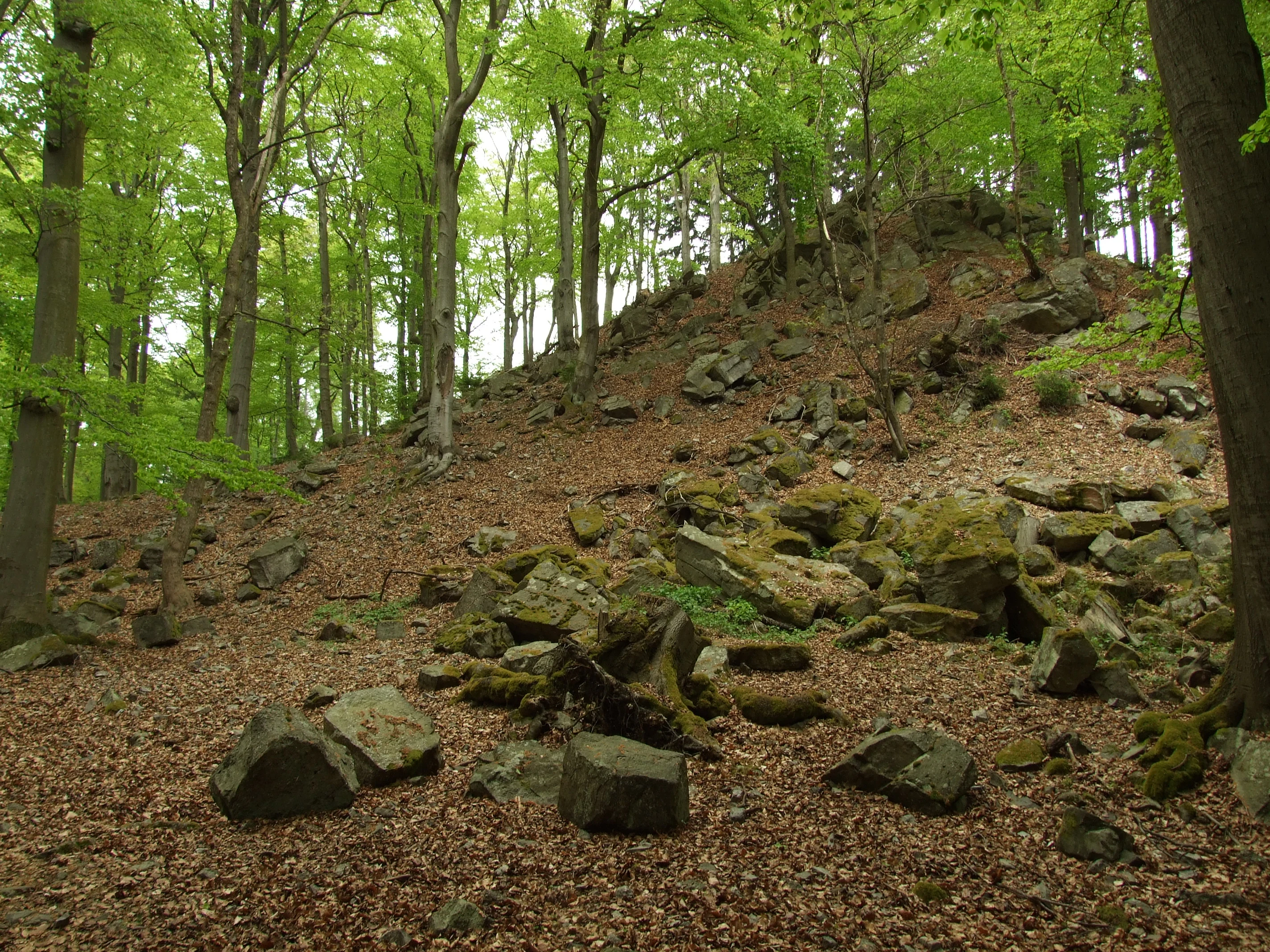
A forest floor covered in dead leaves and mossy rocks, sloping upward toward a rocky outcropping under a canopy of green deciduous trees.
A rocky slope covered in leaf litter within the forest of the Hřebeny range.

Hřebeny Nature Park history and protected-area timeline

The formal establishment of Hřebeny Nature Park followed a clearly defined administrative process in 2009. On 14 September 2009, the Regional Council of the Central Bohemian Region approved the declaration of the park, which then took legal effect on 11 November 2009, fifteen days after publication in the official gazette of the Central Bohemian Region. The park was designated under Regional Decree No. 4/2009 on the establishment of the Hřebeny nature park.

The reasons cited for the park's establishment centered on protecting the landscape character of a forested ridge with a strong predominance of natural values, including near-natural beech and mixed forests with scattered old trees, set on characteristic geological substrate. The decree also recognized the area's significant natural and aesthetic values and its numerous cultural and historical monuments.

In some official documents, including the regional press release announcing the decision, the park was also referred to as Přírodní park Brdy-Hřebeny, reflecting its geographic connection to the broader Brdy highlands. With its designation, the park became the largest nature park within the Central Bohemian Region, anchoring a new layer of regional landscape protection for the Hřebeny and adjacent upland areas.

Hřebeny Nature Park landscape and geographic character

The landscape of Hřebeny Nature Park is defined by forested ridge terrain characteristic of the central Bohemian uplands. The park covers a largely continuous wooded spine forming part of the Hřebeny ridge system, with the surrounding relief shaped by the geomorphological sub-units of the Hřebeny, the Dobříšská pahorkatina, the Příbramská pahorkatina, and the adjacent Brdy highlands. This combination produces a mosaic of ridges, slopes, and valleys that give the park a clearly defined topographic character.

Although forest dominates the visual landscape, the park also contains numerous non-forested sections, including clearings and small enclaves of agricultural or settlement land. The terrain includes distinctive viewpoints and lookout points, such as Hvíždinec, as well as rocky sites that punctuate the otherwise soft ridgelines. Settlements are sparse within the core area; the park deliberately bypasses larger villages while incorporating smaller inhabited patches such as parts of villages and recreational cottage colonies.

A defining physical feature is the forested character of the high ground itself, which transitions into more open landscapes toward the edges of the park. Former military infrastructure, most notably the Dobříš anti-aircraft rocket base located on the ridge between the Jistevník and Vrážky summits, adds a distinctive man-made element to the otherwise natural terrain. Numerous forest roads of varying quality, together with a network of paved and unpaved roads crossing the ridges and valleys, shape the practical geography of the area.

Hřebeny Nature Park ecosystems, habitats, and plant life

The ecological identity of Hřebeny Nature Park is rooted in its extensive forest cover and the natural composition of its woodlands. Near-natural beech stands and mixed forest communities are among the most important features cited for the park's establishment, with scattered old-growth trees adding structural diversity to the canopy. These forests grow on the characteristic geological substrate of the ridge, which contributes to the specific ecological conditions that the park aims to preserve.

Beyond the dominant forest habitat, the park hosts a mosaic of vegetation patterns typical of central Bohemian uplands. Open, non-forested sections create local transitions that support varied microhabitats, while the presence of small water bodies, including fishponds near Trnová u Dobříše, adds aquatic and wetland elements to the broader ecological picture. Rocky outcrops and sloped terrain in areas such as Černolice also support distinct vegetation communities adapted to shallower soils and exposed conditions.

The park encompasses or borders several smaller specially protected areas, including the Kuchyňka, Hradec, and Andělské schody nature reserves, as well as the Černolické skály and Vinice natural monuments nearby. These smaller designations reflect the concentration of ecologically valuable sites within the broader forested landscape and underline the park's role as a protective framework for high-quality habitats in the region.

Hřebeny Nature Park wildlife and species highlights

Hřebeny Nature Park supports wildlife patterns typical of extensive central European forest landscapes, where mature and near-natural woodland structure provides essential habitat for forest-dependent species. The presence of old trees within the beech and mixed forest stands is particularly important for cavity-nesting birds, bats, and saproxylic invertebrates that depend on decaying wood and tree hollows.

The varied topography of ridges, slopes, valleys, and small open areas creates diverse microhabitats that support a range of woodland and edge species. Rocky sites such as those at Černolické skály provide additional habitat for species adapted to cliff and scree environments. Aquatic habitats associated with fishponds and small water bodies in and around the park add another dimension, supporting amphibians and other wetland-associated fauna.

The park's connection to the broader Brdy landscape further enhances its ecological value, allowing wildlife movement across a larger forested continuum. The presence of nature reserves and monuments within and adjacent to the park, such as Kuchyňka, Hradec, and Andělské schody, indicates areas of particular significance for species conservation and habitat protection.

Hřebeny Nature Park conservation status and protection priorities

Hřebeny Nature Park was established specifically to preserve the landscape character of a forested ridge with a clear predominance of natural values. Its conservation objective is broader than the protection of a single species or habitat type; it focuses on maintaining the integrity of the ridge landscape, including its woodlands, geology, and aesthetic qualities, while also recognizing the cultural and historical dimensions of the area.

The primary target is the protection of near-natural beech and mixed forest stands, including those with scattered old-growth trees that contribute to structural complexity and ecological continuity. The park's designation also helps safeguard the underlying geological substrate, which underpins the distinctive terrain of the Hřebeny and surrounding sub-units. By creating a contiguous protected zone of about 184 square kilometers, the park serves as a large-scale buffer and connective element within the broader Brdy landscape.

The park's framework also supports smaller-scale conservation through the inclusion of, or adjacency to, several specially protected areas, including nature reserves such as Kuchyňka, Hradec, and Andělské schody, and natural monuments including Černolické skály and Vinice. These nested protections reinforce the park's role in maintaining ecological value at multiple spatial scales.

Hřebeny Nature Park cultural meaning and human context

The Hřebeny landscape carries a long history of human interaction with forested upland terrain, and the cultural dimension remains a recognized part of the park's value. Numerous cultural and historical monuments are distributed across the park's territory, reflecting centuries of settlement patterns, forestry, and local livelihood that have shaped the visible landscape.

The park includes scattered inhabited areas such as parts of villages, recreational cottage communities, and isolated farmsteads, which embody the continuing relationship between local residents and the surrounding forest. Sites like the former Dobříš anti-aircraft rocket base on the ridge between Jistevník and Vrážky also represent a more recent historical layer, tied to the military history of the area during the Cold War era.

Local heritage is also embedded in the geography itself, with place names, traditional cadastral divisions, and longstanding road and rail connections reflecting the gradual evolution of human presence in the wooded uplands. The recognition of these cultural features within the park's founding rationale underscores their importance as part of the protected landscape character.

Top sights and standout views in Hřebeny Nature Park

The park's greatest highlight is its size and continuity: at roughly 184 square kilometers, it is the largest nature park in the Central Bohemian Region and forms an unbroken forested territory across the Hřebeny ridge and adjacent uplands.

Equally distinctive is the combination of near-natural beech and mixed forests with scattered old trees, characteristic geology, and dispersed cultural heritage sites. Viewpoints such as Hvíždinec and rocky areas like Černolické skály add scenic variety, while the inclusion of nature reserves such as Kuchyňka, Hradec, and Andělské schody underlines the ecological richness embedded within the broader protected landscape.

Best time to visit Hřebeny Nature Park

The park's forested ridge landscape can be experienced meaningfully across much of the year. Late spring and early summer bring lush green foliage and active birdlife, while autumn offers rich coloration across the mixed and beech forests that dominate the ridge, making it a particularly atmospheric season for walking and scenic enjoyment. Winter can emphasize the structural character of the wooded terrain, with open views from the higher ground and quiet forest paths, though conditions on unpaved forest roads may vary.

Monthly climate preview

Long-term representative temperature and precipitation patterns across twelve months

Přírodní park Hřebeny Climate Normals and Annual Temperature Rhythm

Representative coordinate records show measured monthly temperature ranges alongside daily precipitation averages from 1991 to 2020. Examining the complete monthly profile provides deeper context on long-term thermal rhythms across the terrain.
Annual mean9 °C
-2 °C20 °C
Jan-2°
Feb-1°
Mar
Apr
May13°
Jun17°
Jul20°
Aug19°
Sep14°
Oct
Nov
Dec-1°
Warmest month
July

19.7 °C

Coolest month
January

-2.2 °C

Wettest month
June

2.6 mm/day

Driest month
February

1.1 mm/day

Park location guide

Geography guide, regional context, and park location map for Hřebeny Nature Park

Hřebeny Nature Park park geography, regions, and map view in Czechia

Understand where Hřebeny Nature Park sits in Czechia through a broader geographic reading of the surrounding landscape, nearby location context, and its mapped position within the national park landscape.

How Hřebeny Nature Park fits into Czechia

Czech Republic is a landlocked Central European country with a population of approximately 10.9 million people. The nation was established as an independent state on January 1, 1993, following the dissolution of Czechoslovakia. Its capital and largest city is Prague, with other major urban centers including Brno, Ostrava, Plzeň, and Liberec.

Wider geography shaping Hřebeny Nature Park in Czechia

The Czech Republic is a landlocked country in Central Europe. It is bordered by Germany to the west, Austria to the south, Poland to the northeast, and Slovakia to the southeast. The landscape is predominantly hilly, with the territory covering 78,871 square kilometers.

Map view of Hřebeny Nature Park

Use this park location map to pinpoint Hřebeny Nature Park in Czechia, understand its exact geographic position, and read its mapped placement within the surrounding landscape more clearly.

Pigeon | © OpenStreetMap contributors

Location context for Hřebeny Nature Park

Central Bohemian Region

Explore protected ridge terrain, mixed woodland habitats, and forest environments across Central Bohemia

Přírodní park Hřebeny Photos and Landscape Scenery Visual Archive

Visual records capture the extensive forested ridge terrain, ancient beech stands, and rocky viewpoints that define the protected landscape of Přírodní park Hřebeny. Examining field photography helps researchers and visitors analyze the upland topography, forest cover, and ecological continuity of the region.

A forest floor covered in dead leaves and mossy rocks, sloping upward toward a rocky outcropping under a canopy of green deciduous trees.

A rocky viewpoint ledge overlooking a vast, misty landscape of forested hills in the Hřebeny Nature Park.

Park atlas

Compare adjacent upland terrain, forested ridges, and regional conservation areas.

Parks Near Přírodní park Hřebeny and Surrounding Protected Landscapes

Browsing other protected areas near Přírodní park Hřebeny reveals interconnected forested terrain and adjacent upland habitats across central Bohemia. Comparing these surrounding reserves provides deeper geographical context into regional landscape conservation and wooded ridge systems.
Natural monumentCzechia
About 13 km away#1 closest

Southwest

Vinice Natural Monument: Geological Heritage and Cambrian Stratigraphy in Central Czechia

Protected xeric woodlands and ancient marine sedimentary records

Vinice serves as a vital protected area in the Příbram district, safeguarding one of the world's most important Cambrian fossil sites. Its steep, south-facing slope above the Litavka River offers a visual map of geological history, where exposed rock sequences meet diverse forest and grassland habitats. This site remains a key reference for understanding Bohemian natural heritage and the long-term evolution of local terrain.

Area
0.423 km²
Established
1999
Relief
Upland
Climate
Temperate
A horizontal watercolor illustration depicting rolling green hills, scattered trees, and foreground flowers with soft mountains in the distance.
Nature reserveStředočeský kraj
About 15 km away#2 closest

West

Na horách Nature Reserve: Geographic Context and Protected Landscape Discovery

Středočeský kraj, Czech Republic

Na horách serves as a protected landmark for thermophilous vegetation within the Brdy Highlands. This nature reserve provides a clear window into how skeletal soils and historic land management sustain unique dry-grassland plant assemblages across a sloping, varied Bohemian terrain.

Area
0.049 km²
Established
1997
IUCN
IV
Relief
Upland
A horizontal watercolor illustration of gentle, rolling green hills under a pale sky, with clusters of stylized trees in the foreground and faded distant mountains in the background.
Natural monumentPrague
About 23 km away#3 closest

Northeast

Radotínské skály Natural Monument: Geological Mapping and Protected Landscapes in Prague

Geological profiles and steppe biodiversity near the capital.

Radotínské skály stands as a key protected area in Prague, showcasing an internationally significant stratigraphic record of the Prague Basin. From exposed rock walls to warm-loving forest-steppe communities, the site offers a detailed look at how geological heritage persists alongside urban development, making it an essential destination for those exploring the regional geography of the Czech Republic.

Area
0.277 km²
Established
1988
IUCN
III
Relief
Upland
Natural monumentPrague
About 23 km away#4 closest

Northeast

Zmrzlík Natural Monument: Geological Profile and Protected Landscape Map of Prague

Silurian stratotype sites and calcareous grassland ecosystems

Zmrzlík is a protected natural monument in Prague, defined by its rich Silurian geological sequences and fossil-bearing limestone deposits. The site offers a clear view into the Kopanina Formation, featuring distinct basaltic volcanic remains and rare xerothermic vegetation. This map-based resource details the terrain and ecological mosaic of the area, ranging from rocky ridges to the valleys of the Mlýnský potok.

Area
0.164 km²
Established
1988
IUCN
IV
Relief
Upland
Watercolor painting of a rolling Czech landscape featuring meadow flowers in the foreground, forest in the midground, and distant hazy hills.
Natural monumentStředočeský kraj
About 25 km away#5 closest

North

Markův mlýn Natural Monument: Exploring the Geography and Protected Flora of Central Bohemia

A rare botanical reserve featuring unique rock-steppe plant communities

Markův mlýn is a protected natural monument situated in the Středočeský kraj region, characterized by its rare combination of dry, thin-soil hillside meadows and stream-influenced valley terrain. The area serves as a critical habitat for specialized steppe flora, including the protected Bohemian pasqueflower. This record offers a detailed look at the site's compact geography and the specific environmental conditions that sustain its unusual plant communities.

Area
0.001 km²
Established
1987
IUCN
III
Relief
Lowland
Nature reservePraha 5
About 26 km away#6 closest

Northeast

Prokopské údolí Nature Reserve: Geological Mapping and Protected Area Discovery

A limestone karst landscape situated within the Praha 5 district

Prokopské údolí is an essential protected nature reserve in Praha 5, featuring a deep limestone valley that serves as a globally significant site for Paleozoic fossils and karst geography. This protected landscape encompasses a range of habitats including rock steppes, thermophilic woodlands, and volcanic outcrops, providing a unique look at urban-adjacent nature conservation and historical limestone quarrying within the Czech Republic.

Area
1.71 km²
Established
1978
IUCN
III
Relief
Upland
Nature reserveStředočeský kraj
About 27 km away#7 closest

East

Vlčí rokle Nature Reserve: Geological Ravines and Ancient Beech Forests in Středočeský kraj

Mapping protected natural monument boundaries and ancient woodland remnants

Explore the geological and botanical features of Vlčí rokle, an exceptional nature reserve set within the Středočeský kraj. This protected area safeguards a fragment of ancient beech forest and a granite-boulder-strewn ravine, representing a classic example of central Bohemian geological and ecological heritage.

Area
0.085 km²
Established
1990
IUCN
III
Relief
Upland
Watercolor painting of a pastoral landscape featuring a tree, a large rock, and soft hills in the background with a pale sky.
Natural monumentStředočeský kraj
About 28 km away#8 closest

East

Skalsko Natural Monument: Mapped Wetland Landscapes and Protected Meadow Geography

A representative habitat in the Středočeský kraj uplands

Focusing on the conservation of sensitive wet meadow ecosystems, Skalsko serves as a key reference for the biodiversity of the Říčany Plateau. This site showcases a mosaic of flora, including rare orchids, set against the backdrop of the geologically distinct Central Bohemian uplands, providing a structured look at one of the region's most important protected natural monuments.

Area
0.036 km²
Established
2008
IUCN
IV
Relief
Upland

Common questions about visiting, size, designation, and location context for Hřebeny Nature Park

Hřebeny Nature Park FAQs for park facts, access, geography, and protected area context

Find quick answers about Hřebeny Nature Park, including protected-area facts, park geography, trail and visitor context, and how the park fits into its surrounding country and regional landscape.
MoriAtlas Explorer

Continue Your Protected Areas Search Across the Global Atlas

Deepen your exploration by continuing the structured search for national parks and protected areas worldwide. Utilize the comprehensive filtering capabilities to compare different conservation landscapes and refine your understanding of global park geography. Discover more about the distribution and characteristics of protected natural areas.

Global natural geography