Why Hülser Bruch stands out
Hülser Bruch is best known for being the largest and ecologically most distinctive nature reserve in Krefeld, preserving remnants of the Lower Rhine's historic marshland or "Bruch" landscape on a glacial plain. The reserve stands out for its mix of relict wet meadows, coppice and pollarded willow woodlands, and long earthen embankments (Dyks) that together form one of the region's most complete surviving examples of an old cultural wetland landscape. Its position beside the glacial Hülser Berg, the area's highest natural elevation, gives the protected area a notable geomorphological character shaped directly by the actions of the Pleistocene ice sheets.
Hülser Bruch history and protected-area timeline
The history of Hülser Bruch is closely tied to its geological origins and its long use as a low-intensity landscape. During the late phase of the Saalian glaciation, roughly 140,000 years ago, glaciers advancing into the Lower Rhine region pushed up ridges of clay and stone, creating a line of push moraines whose highest surviving expression here is the Hülser Berg. As the ice eventually melted, meltwater and the repeatedly shifting Rhine river carried sediment into the surrounding landscape, flattening former glacial drainage channels and leaving the flat, poorly drained basin in which the modern reserve sits.
For centuries, the heavy clay soils and persistently high groundwater of this basin made the area unsuitable for plowing and cropping. Instead, the local population used it mainly for collecting firewood and litter, removing dead branches, and gathering leaf litter or bedding material from the woods and scrub. This kind of low-intensity exploitation preserved the wooded and semi-open character of the wetland and prevented its conversion to farmland.
The term "Bruch" itself reflects this history. It derives from older Germanic words, including Old High German bruoh and Middle High German bruoch, and is cognate with Low German Brook or Brock and Dutch broek, all describing swampy ground with woodland or former woodland cover. The name Hülser Bruch thus literally records the area's identity as a historically moist, wooded lowland tied to the village of Hüls.
In 2002, the area was formally designated as a nature reserve, making it the largest such area within the municipal boundaries of Krefeld and consolidating decades of growing recognition of its ecological and cultural value.
Hülser Bruch landscape and geographic character
The landscape of Hülser Bruch is defined by the contrast between a broad, flat glacial plain and a steep, prominent hill rising just to its north. The plain itself originated as a shallow glacial channel filled and leveled by meltwater and by sediments carried later by shifting Rhine channels, producing a wetland-prone surface that still holds water relatively close to the surface today.
To the north, the Hülser Berg, the highest natural elevation in the area at 63 meters, is the surviving remnant of a push moraine formed when the Saalian ice sheet pushed ridges of clay and stone ahead of its front. Wind, weather, and later river erosion wore down much of this glacial topography, but the Hülser Berg survived as a visible landmark at the edge of the reserve and helps define the visual character of the protected area.
Drainage of the basin is currently governed by the Gelderner Fleuth, a small watercourse that is also called Flöthbach or Kütze Kall locally. It carries water out of the Hülser Bruch and ultimately into the Niers, one of the larger tributaries of the Meuse basin. The combination of clay-rich substrate, high groundwater, and gently sloping surface water defines a wet-meadow and brook-channel environment typical of the historic Lower Rhine.
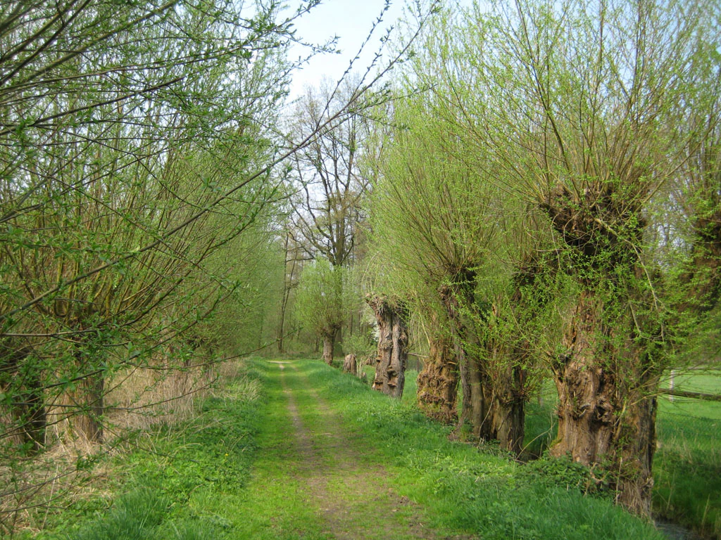
Long earthen embankments, locally called Dyks and lined with pollarded willows, cross parts of the reserve and are among the most distinctive visual features of this cultural landscape, recording how earlier generations managed the difficult ground.
Hülser Bruch ecosystems, habitats, and plant life
Ecologically, Hülser Bruch is interesting because it preserves several habitat types that are increasingly rare in the intensively used Lower Rhine plain. The reserve contains low-intensity grassland, including small relict wet meadows that represent the last fragments of former lowland fens, embedded in a much larger matrix of woodland, scrub, and field.
Woodland structure in the reserve is varied and historically shaped. It includes coppice woodland (Niederwald), in which trees were traditionally cut on short rotations for fuel wood, and middle forest (Mittelwald), a layered system combining standard trees with a coppice understory. Both systems support a richer ground flora and dead-wood habitat than modern high forest of a single age class would, and they line the reserve's characteristic Dyks, the raised field boundaries that cross the wetland.
Pollarded willows (Kopfweiden) are a recurring and visually distinctive feature of the habitat mosaic. Alongside hedgerows, which contribute to structural connectivity for many species, these elements help maintain the old cultural landscape that conservation programs now aim to enhance rather than replace. The combination of wet meadows, Dyks, hedges, and structurally rich deciduous woodland is what makes Hülser Bruch a regionally unique ecological site within the Krefeld city limits.
Hülser Bruch wildlife and species highlights
Hülser Bruch supports a varied fauna thanks to its mosaic of wet meadow, coppice woodland, hedgerow, and standing dead wood. The reserve hosts numerous common wild mammal species, and its abundance of small wet pools and ditches provides habitat for several amphibian species typical of the Lower Rhine lowlands.
Birdlife is one of the prominent features of the protected area. The mature deciduous and mixed woodland, including older trees with cavities and dead limbs, supports species such as the Black Woodpecker, while the structured hedgerow and open meadow mosaic attracts the Eurasian Golden Oriole, whose song is a characteristic sound of warmer seasons in such landscapes. The Little Owl, a species that has declined sharply in much of western Germany, is recorded in the reserve, and the mix of open hunting habitat and mature trees with nesting cavities makes the area suitable for the Hobby, a small falcon that hunts insects and small birds over open ground.
Together, these woodland, hedgerow, and meadow specialists illustrate why the area's combination of habitats, rather than any single habitat type, is what makes Hülser Bruch ecologically valuable for wildlife in the Krefeld region.
Hülser Bruch conservation status and protection priorities
Hülser Bruch has been formally protected as a nature reserve since 2002, and at 430 hectares it is by far the largest such area within the city of Krefeld. The reserve's conservation significance lies primarily in preserving what remains of a once more widespread type of cultural landscape: a flat, wet, partially wooded lowland shaped by glacial geology and centuries of low-intensity human use.
The stated conservation goal is the preservation and ongoing development of the "Bruch" landscape, along with the safeguarding and stabilization of its distinctive features. Management therefore focuses not on converting the area into purely natural habitat, but on maintaining the cultural-landscape mosaic of wet meadows, Dyks, coppice woodland, hedgerows, and pollarded willows that gives Hülser Bruch its regional distinctiveness.
The wet meadows, in particular, are treated as conservation priorities because they are the remnants of the area's former lowland fens, now reduced to a small fraction of their historical extent. Beyond its intrinsic ecological value, the reserve functions as a refuge for woodland and meadow species that have lost much of their former habitat in the surrounding Lower Rhine farmland, and it is connected to a wider network of Krefeld nature reserves, including those along the nearby Flöthbach and along the Latumer Bruch and Orbroich brook systems.
Hülser Bruch cultural meaning and human context
The cultural landscape character of Hülser Bruch is central to its identity. For centuries, the heavy clay soils and high groundwater made plowing impractical, so the area was used mainly to gather firewood and litter from wooded and scrubby ground. This long history of low-intensity, non-plowing land use is the reason the mosaic of small meadows, coppice woods, hedgerows, and pollarded willows has survived at all.
The local name "Bruch" itself embeds this cultural-historical context. It descends from Old High German bruoh, Middle High German bruoch, and is paralleled by Low German forms such as Brook, Brock, and Broich, and by Dutch broek. All of these words historically denoted a swamp or marshy area with a vegetation cover of bushes or woodland, exactly the kind of environment that still defines the reserve today.
Hülser Bruch therefore is not just a preserved natural site, but a living artifact of an older Rhine-landic land-use tradition in which unplowable wetland was integrated into the rural economy through woodcutting, pollarding, and meadow management rather than being drained and farmed.
Top sights and standout views in Hülser Bruch
Hülser Bruch is a compact but unusually varied protected area that combines glacial geology, relict wetland habitat, and a historic cultural-landscape mosaic within the city limits of Krefeld. Its most striking features are the contrast between the flat glacial plain and the adjacent Hülser Berg, the survival of small but ecologically precious wet meadows that recall former lowland fens, the characteristic Dyks lined with pollarded willows, and the mixture of coppice woodland and middle forest that gives the area its habitat richness.
The reserve's ecological importance rests not on any single rare species, but on the persistence of this whole habitat mosaic in a region where most comparable ground has long since been drained or plowed, which is what makes it the most important nature reserve in Krefeld.
Best time to visit Hülser Bruch
The character of Hülser Bruch shifts notably with the seasons in ways that are typical of Lower Rhine wet woodland and meadow landscapes. Spring and early summer bring the most active birdlife, when woodland species such as the Black Woodpecker are vocal and the Golden Oriole and Hobby return to the area, while the wet meadows and ditches fill with amphibian activity.
Late spring and early summer are generally the most rewarding time to experience the reserve's mix of flowering meadow-edge vegetation and fresh deciduous foliage. Autumn also has its own appeal, when the deciduous woodland and pollarded willows turn color and the reserve hosts the annual Seidenraupen-Cross, a cross-country running event that draws visitors into the area. Winter visits are quieter but can offer unobstructed views of the Dyks, the woodland structure, and the surrounding glacial landforms, including the Hülser Berg to the north.